An Implementation of Change Detection System for High-resolution Satellite Imagery using a Floating Window
Young-Jae Lim, Soo Jeong, Kyung-Ok Kim
Satellite Imagery Information Research Team, Spatial Information Technology Center, ETRI-CSTL 161 Kajong-Dong, Yusong-Gu, Taejon 305-350, KOREA
Phone : +82-42-860-1034 Fax : +82-42-860-4844
E-mail : [email protected], [email protected], [email protected]
Abstract
Change Detection is a useful technology that can be applied to various fields, taking temporal change information with the comparison and analysis among multi-temporal satellite images.
Especially, Change Detection that utilizes high-resolution satellite imagery can be implemented to extract useful change information for many purposes, such as the environmental inspection, the circumstantial analysis of disaster damage, the inspection of illegal building, and the military use, which cannot be achieved by low- or middle-resolution satellite imagery.
However, because of the special characteristics that result from high-resolution satellite imagery, it cannot use a pixel-based method that is used for low-resolution satellite imagery. Therefore, it must be used a feature-based algorithm based on the geographical and morphological feature.
This paper presents the system that builds the change map by digitizing the boundary of the changed object. In this system, we can make the change map using manual or semi-automatic digitizing through the user interface implemented with a floating window that enables to detect the sign of the change, such as the construction or dismantlement, more efficiently.
1. Introduction
By the comparison and analysis among multi-temporal satellite images, change detection technology for detecting of the change aspect about time-series on the earth, is a useful technology that can be applied to various fields, such as the environmental inspection, the urban planning, the forest policy, the updating of geographical information and the military use.
It is very important for detecting the useful change information that selection of proper images for comparison.
It should be decided an interval of photographing times following the change information to want to be get
suitably, and we must select images that are alike in spectral characteristic, spatial resolution and radiometric characteristic.
In addition to them, environmental conditions, under which the compared images were acquired, must be considered sufficiently. Useful change information can be extracted when environmental conditions, such as atmospheric condition, moisture in the soil, climatic characteristics, and tidal condition, are similar to each other.[1]
After being applied geometric co-registration and
radiometric co-registration to overlapping with another, it
can be extracted change information with various algorithms.[3]
Most simple change detection algorithm, they are image algebra change detection methods like that band differencing and band rationing use operation between bands.
The band differencing method, is a method that extracts change elements with differencing between pixels in two images, is simple algorithm and that can be quantitative analysis. But, they may be able to detect as change elements that spectral characteristics like seasonal elements and sun angle in the photographing times. So, to complement it, we may use band rationing method to use ratio between two pixels.[1]
Most important element is decision of the threshold to define the change pixels, we can get it as experientially decided value or standard deviation of mean.
As the similar to this method, there is change detection method to use write function memory insertion. In this method, if you assign same bands in two images to red and green, respectively, and change area is displayed to red or green and no change area is displayed to yellow, a composite color.[1]
This method has advantage that can compare and analyze with two or three images at once, but it cannot do quantitative analysis, merely intuitive analysis be possible.
Post-classification comparison change detection method, most generally utilized change detection method to quantitative analysis, to detect change information among classified images using supervised or non- supervised image classification methods to perform objectification and minimization of comparison information, has advantage that can get from-to information with pixel based change detection matrix, but its accuracy depends on classification algorithm absolutely.[4]
Above-mentioned remark methods, to compare pixel-by- pixel basically, are not sufficient by change detection methods for the high-resolution satellite images because
high-resolution satellite images are considered in object units as building, road so on than spectrum specification of pixel units
Especially, there can't be used any more in high- resolution images, because their observed contents are different from middle- or low- resolution imagery as occlusion area, shadow of building and effect of roadside trees so on.
For solving these problems, there is a method that can get change information with matching between linear segments to be extracted from two images. This method is less sensitive at the photographing condition as change of illumination and so on than pixel-by-pixel comparison methods, but it must be in needed to more complex match algorithm as well as extraction errorless and sufficient number of line segment to construct the object models.[2]
To be used by another method for detection changes in high-resolution satellite images, head-up digitizing method, is a method to abstract manually by a specialist the changed object with comparison two images in every case. This method is depend on operator's observation entirely, so it have disadvantage in which operator is tired easy but it is solitary method because impossible to automatic classification and analysis for high-resolution satellite imagery in the current technological level.
In this paper, we present a head-up digitizing system to extract change information more easily and more quickly through implementation with a concept of cognitional psychology to design user interface.
First, we introduce entire construction of the change detection system to be implemented and its characters in details. And next, we describe the main object in the design of UI and a method of change detection by observation with the naked-eye to use the floating window.
2. Implementation of change detection
system for high-resolution satellite imagery
As described above, we can more precisely observe statuses on the earth in the high-resolution satellite imagery compared with the middle- or low- resolution satellite imagery as there can be observed buildings, roadside trees and a median strip of the road.
By these characteristic, we can get more precise change information from the high-resolution satellite imagery through naked-eye observation, but there cannot applied pixel based change detection methods because these are vulnerable to noises.
The implemented system does function to change detection for the high-resolution satellite imagery of these characteristic.
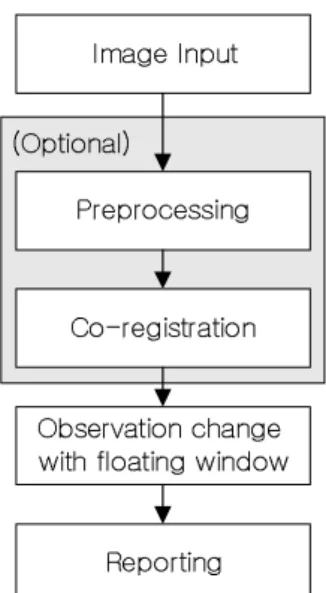
The constitution of the implemented change detection system is followed.
OvP
pGp
w
jT
vGG
GG
y
Fig. 1. The constitution of the proposed system
̾G Process of preprocessing and co-registration
As compared with existing pixel-by-pixel automatic change detection methods to have vulnerable points such as apprehension of wrong extraction by geographical disagreement, difference of radiometric characteristic and noise in images, this system to compare using human naked-eye has an advantage to be strong in effects of these bad factors because human visual system is able to accommodate to ambiguity until a limited
degree.
Despite of that it needs not image processing or co- registration processes as them in pixel-based automatic change detection methods, there is necessary to remove noise and image enhancement for minimization of operator's exhaustion. Especially, co-registration of geometric coordinate and radiometric co-registration are need because two images are compared in the state to be overlapped.
In this system, we can select one of mean filter or median filter to remove noise, and it can do execution of geometric transformation of affine or polynomial methods using user-selected tie points.
And, it can be applied a radiometric co-registration by histogram matching method to be similar spectral characteristic of images.
̾G The floating window for search changed area by the
naked-eye.
By mentioned research results about change detection from a cognitional psychological point of view, It is difficult to detect changes between two stimuli at human visual systems in several case to be called change blindness as follows.[5]
- Gap-contingent: It is difficult to detect the change if it is changed from original stimuli to changed stimuli among a gap of time.
- Saccade-contingent: It is difficult to detect the change if saccade occurs extremely for comparing with two images.
- Shift-contingent: It is difficult to detect the change when displayed whole region is shifted abruptly.
- Blink-contingent: It is difficult to detect the change on eye-blink by the rapid change of visual-stimuli.
- Occlusion-contingent: It is difficult to detect the change to occur while the changing item is briefly occluded.
- Cut-contingent: As involving in movies, they are
usually difficult to detect that changes are occurred
while change images is displayed continuously in the short time. In this case, human visual system detects not change but motion.
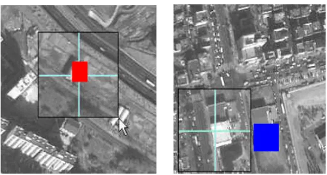
A concept of floating window, UI design based on consideration of cognitional psychology for avoidance these change blindness as possible, is introduced in this system for the rapid and exact extraction change information.
With the floating window following a mouse cursor on the image acquired at time N, an operator make an observation on parts of the image acquired at different time, N+1. Figure 2 shows the available placement of the floating window around the mouse cursor. Although the positions of 4, 5 and 6 can be considered to be suitable places from the fact that human visual system can detect changes better in horizontal comparison than vertical one, they are not practically available because more than a half of the image to be compared is covered by the floating windows. The first position in the figure 2 is selected as the most suitable place for the floating window experimentally.
X [
^
\ _
Y Z
]
`