융복합 공간정보의 국토계획 분야 활용가능성 분석 - LH 국토․ 주택관련 미래사업 예시를 중심으로
The Analysis of the Possibility for Using Converged Spatial
Information(CSI) in National Territorial Planning - The Case Study of LH's Future Business about Land and Housing
최 준 영*
Jun Young Choi
요 약 공간정보의 폭발적 증가와 공간정보 활용 기술의 발전으로 국토의 비교우위를 유지하기 위한 공 간정보와 도시계획 및 부동산 정보 융복합 수요가 증가하고 있다. 본 논문에서는 국토 경쟁력 강화를 위해 필요한 융복합 공간정보의 장래 국토공간 계획 및 이용 활용도를 전망해 보았다. 이를 위해 국토, 주택분야 공기업인 한국토지주택공사(LH)의 장래 2029년까지 6대 분야별 미래사업을 도출하였다. 또한 문헌조사를 통 해 도출한 7종의 융복합 공간정보의 미래사업 분야별 활용도를 설문조사하여 국토주택개발 분야의 미래 활 용을 분석해 보았다. 분석결과 3D, 모바일 데이터, 정형 빅데이터, 지오센서, 참여형 공간정보 순으로 활용도 가 높은 것으로 나타났고, 사업분야에서는 도시 및 지역개발이 활용도가 높은 것으로 나타났다. 미래 융복합 공간정보 활성화를 위해서는 토지이용 이외에 해양이용, 연안이용, 지하공간 등 균형있는 국토이용 공간정보 의 구축이 필요한 것으로 나타났다.
키워드: 융복합 공간정보, 미래 국토계획, 국토 경쟁력, 국토 이용
Abstract Due to explosively increasing utilization in spatial information and a rapid development in geospatial technology related to national territorial and housing, there are increasing demands for converging spatial information on not only urban planning and real estate data but also newly generated data from smart phone, GPS to achieve comparative advantage of national territory. In this paper, we prospect the utilization of Converged Spatial Information(CSI) to future national territorial planning for the purpose of enhancing territorial competitiveness. For this purpose, considering the Korea Land and Housing corporation(LH) takes charge most of government's land and housing development projects, CSI usage of this company's 6 future business domains until 2029 were used as a case study. Also, 7 CSIs derived from literature review were surveyed to find the degree of CSI utilization in the national territorial future. In the analysis result, it was found that 3D data and mobile data among others have higher degree of utilization, and urban and regional development is the most highly utilizable domain for CSIs. After all, to revitalize the use of CSI in national territorial future, it is required to do a balanced construction of territorial use spatial information about marine use, coastal use, underground space besides land use.
Keywords : Converged Spatial Information(CSI), National Territorial Future, National Territorial Competitiveness, National Territorial Use
This work was written based on the author's conference article(Using Converged Spatial Information(CSI) for territorial and housing planning - The Case Study of LH).
Author would like to thank anonymous referees for helpful comments on earlier draft of this paper.
*
Jun Young Choi, Spatial information office, Korea Land and Housing Corporation, [email protected](Ph.D.)
1. 개 요
1.1 연구의 배경
국토는 여러 요인에 의해 서서히 변화되며, 일단 변
화된 국토는 원래 상태로 되돌리기 어려운 속성을 가
지는 시간지체성과 불가역성을 가지고 있어서 장기적
안정에서의 전망이 필요하다[25]. 장기전망을 필요로
하는 미래 국토계획의 주요 기능은 정교한 예측뿐만
아니라 장기정책이 정의되거나 개선되기 전에 다양한 계층의 의사결정자들이 장래의 국토개발을 형성할 원 동력(driving force)을 인식하도록 하는 것이다[14]. 이 와 같은 국토계획에서는 기초조사, 입지타당성 분석, 계획 및 설계 시뮬레이션, 정책평가 등 정책수립, 집 행, 모니터링 과정에서의 공간의사결정 지원을 위해 공간정보 및 기술이 중요한 역할을 하게 된다[7, 20].
이처럼 공간정보 및 기술은 3차례에 걸친 국가지리 정보체계 추진으로 발전해 왔다. 최근에는 공간정보 와 타정보간의 융복합화가 활발히 진행됨에 따라 국 토분야의 활용이 손쉽워졌고, 국토공간 첨단화에 있 어 공간정보의 중요성이 강조되고 있다[4]. 일례로 공 간정보 기술이나 자료를 보유하고 있지 않아도 필요 로 하는 기능을 활용하거나 자신이 만든 공간정보를 쉽게 지도상에 표시할 수 있게 되었다. 뿐만 아니라 공공데이터(public domain data)의 개방으로 공간정보 와 결합 가능한 데이터는 보다 늘어났고, 스마트폰의 GPS(Global Positioning System)를 이용한 위치식별기 술의 발달과 트위터, 페이스북 등 SNS(Social Network Service)의 활용증가로 공간정보에 행정정보 및 SNS 를 통합하여 분석․활용하는 공간 빅데이터(Spatial Big Data) 체계 구축도 제기되고 있다[29].
이에 따라 국토계획에서도 국토가 경쟁력 있는 환 경을 제공하고 지역혁신의 기초역할을 하는 국토 경 쟁력(National territorial competitiveness)에 기초한[3]
공간정보와 기술을 활용하려는 노력이 시도되어 왔 다. 즉, 국토가 경쟁하면서 기업을 유치하고 외부 직접 투자를 유인하기 위해 물리적 외부효과, 접근성, 환경 의 질과 같은 요소를 통한 입지경쟁력 강화와 같은 국토계획에 공간정보가 큰 역할을 할 수 있다는 것이 다. 본문에서는 국토의 경쟁력 강화를 위해 활용될 수 있는 공간정보의 범위를 공간정보와 연계하여 활용이 가능한 모든 정보라고 할 수 있는 융복합 공간정보 (Converged Spatial Information)로 확장하여 활용가능 성을 분석하고자 하였다. 최근에는 공간정보 기반의 융복합화 현상이 공간정보의 활용을 확산시키고 있어 공간정보산업의 경제적 잠재성과 발전가능성까지도 증가시키고 있다[5].
하지만 융복합 공간정보가 국토계획과 같은 공간의 사결정지원 업무에 바로 적용되는 것은 쉽지 않다. 토 지이용정보
1)및 주택공간정보의 계획분야 활용 사례 에서와 같이 분석목적에 맞는 공간단위(spatial unit of
1) 토지공간 위에서 나타나는 사회적, 공간적, 물리적 성격 의 속성정보가 실제 공간상에 투영되어 지리적인 위치 및 위상관계를 나타내는 도형정보와 결합되어 나타나는 정보로 국토도시계획에서 활용되는 기본정보이다[25].
analysis)의 설정과 연계정보의 구축 및 활용방안 마련 이 선행되어야 하기 때문이다[9, 25]. 따라서 공간정보 기술이 계획업무에 적용되는 시차를 감안할 때 현재 보다는 미래 국토계획업무의 적용가능성을 분석하여 활용성을 탐색하고자 한다. 미래 국토는 인구구조 양 상 및 도시비전의 변화에 따른 도시의 축소(urban shrinkage), 미이용 국토공간의 이용 등과 같은 패러다 임의 변화가 예상되어 다양한 공간정보 활용 및 분석 방법이 요구된다[21].
본 논문에서는 국토계획의 세부분야별 융복합 공간 정보의 실질적 활용방향과 합의를 도출해 보기 위해 국토계획과 관련된 국가사업을 수행하는 공기업인 한 국토지주택공사(LH)에서 구상한 미래 국토사업을 대 상으로 하였다. 논문의 구성은 다음과 같다. 2장에서 는 계획과 관련된 정보 요구사항 및 미래 국토계획에 서 공간정보 활용 관련 선행연구를 통해 시사점을 도 출하였다. 3장에서는 국토계획에 적용 가능한 융복합 공간정보를 도출하기 위하여 융복합 공간정보에 대해 정의하였고, 문헌조사를 통해 미래에 적용가능한 공간 정보의 패러다임을 선정하였다. 4장에서는 설문조사 를 통해 LH의 미래 사업을 대상으로 활용가능한 융복 합 공간정보를 분석하여 장래 국토계획의 활용을 위한 시사점을 제시하고 5장에서는 결론을 제시하였다.
1.2 연구방법
분석방법은 첫 번째로 공간정보 관련 저널 가운데 다양한 국토분야의 공간정보 분석 및 활용사례를 담 고 있는 Environment and Urban Planning B(EPB), Computers, Environment and Urban Systems(CEUS) 등 두 개 저널의 최근 5년간 국토계획 분야 분석 및 활용사례를 조사하였다. 둘째, 메가 트렌드(mega trend) 분석을 통해 도출된 LH의 미래사업을 국토, 도 시, 주택 분야로 구분하고 기간을 단기, 중기, 장기로 나누었다[22]. 기술 분야별 활용전망은 계획방법에 관 한 선행연구의 기준을 참고해 미래 활용분야를 분석, 설계, 과정으로 분류하였다. 또한 국토 미래 계획에 대한 사례조사를 통해 공간정보의 역할 및 활용방향 을 조사하였다. 분류된 미래사업에 대해서는 업무분 야별로 경력 7년 이상의 LH 직원을 대상으로 5점 리 커트 척도로 융복합 공간정보의 활용도를 1점에서 5 점 사이의 값을 기재토록 하였다.
2. 선행연구
2.1 계획과 관련된 정보 요구 관련 연구
계획에 활용 가능한 융복합 공간정보 도출을 위해
Country Plan / Report Direction of Plan Role of Spatial Information
EU
Scenarios on the territorial future of
europe 2030
∙ ESPON(European Spatial Planning Observation) predict the territorial future of europe 2030 based on the baseline, competitiveness oriented and cohesion oriented scenario for the population, energy, economy, transportation, governance and climate change field.
∙ Using cartographic to display the result of the future prediction
France Territoires 2040
∙ DATAR predict territorial future of france based on the cross analyzing the 7 spatial systems and two objectives and as a result 28 scenarios are derived.
∙ Used as a basemap for future spatial planning scenario
Netherland Territoires 2030
∙ VROM(Ministry of housing, spatial planning and the environment) suggest future national territory as decentralization (palette), green landscape (parklandschap), flow (stromenland) and urban environment (stedenland).
∙ Land Use Scanner, land use distribution model based on the RasterPlan GIS, prospect future land use by
quantitatively representing intensity of present land use, attractiveness of future land, regional requirement, etc.
Germany
Szenarien zur raumentwicklung
2015/2040
∙ BBSR(federal institute for research on building, urban affairs and spatial development) prospect spatial structural development based on the spatial structure conceived by Germany and Europe.
∙ Used as a basemap for future spatial planning scenario
Korea
Future prospect strategies for national territorial
development
∙ KRIHS derive four scenarios based on the 10 mega trends of low carbon energy, safe territorial land use, urban regeneration, etc.
∙ Simulating dispersion of urban land use using ABM based What-If simulation which utilize spatial data such as Land cover, elevation, slope, restricted development area, population etc.
Source: BBSR(2003), DATAR(2011), DIACT(2006), ESPON(2007)
Table 1. Territorial future plan of each country and role of spatial information 서는 계획과 관련된 정보 요구사항을 파악하는 것이
필요하다. 정보 요구사항과 관련한 계획 기능을 구분 하면 중앙정보 기능(central intelligence), 현상진단 기 능(false tasking), 정책결정 기능(policy clarification), 계획입안 기능(detailed development planning), 검토 및 갱신(feedback and review)으로 나눌 수 있다[6].
이때 각 단계별로는 사회경제정보, 토지이용정보 등 계획관련 현황정보의 수집과 저장, 현황정보의 분석, 정책대안(scenario) 작성, 계획안 작성 및 검토 등에 정보가 요구된다. 또한 이 기능을 계획 수립과 관리로 구체화하면 자료수집, 분석, 평가, 대장관리를 위해 이 용된다.
도시정보를 다루는 조직과 관련해서 도시정보 피라 미드(Urban Information Pyramid)의 개념을 도입한 Huxhold는 계획 단계별 정보 수요를 분석하였다[18].
이 피라미드에서는 최하층에 시행(operation), 중간에 관리(management), 최상위층에 정책(policy)의 업무 기능을 두었다. 이때에 수평단계에서는 서로 다른 정 보가 결합되고 수직방향으로는 데이터가 요약되어 총 체적인 정보가 이용된다고 보았다. 한편, 미래에 GIS
가 계획에 기여하는 바를 Drummond and French는 분 석(analysis), 설계(design), 과정(process)으로 나누었 다. 장래 계획에서 GIS 활용에 대한 분석에서 계획단 계에서는 각종 대안을 분석하기 위한 3차원의 활용, 설계에서는 대안의 생성, 과정에서는 참여형 GIS의 활용을 제시하였다[13].
이상의 계획에서의 정보수요 분석결과를 정리해 보 면 국토분야에 활용 가능한 융복합 공간정보를 도출 해 보기 위해서는 계획에 필요한 정보수요 도출을 위 한 계획단계의 구분이 필요하고 계획의사결정을 위한 정보의 결합과 요약이 필요함을 확인할 수 있다.
2.2 미래국토계획의 공간정보 활용 관련 연구
미래 국토에 관한 계획사례로는 EU, 프랑스, 네덜란
드, 독일, 한국의 사례를 검토하였다(Table 1)[26]. EU,
프랑스, 독일의 계획에서는 공간정보를 현황분석과
미래 공간전망을 표현하기 위해 배경지도로 사용하였
다. EU의 경우에는 카토그래픽(cartographic)을 효과
적으로 사용하여 분석의 양에 따라 각국의 면적을 시
각적으로 과장하여 표현하였다. 네덜란드와 한국의 계획
2)에서는 각각 Land Use Scanner, What-IF 등의 공간 시뮬레이션 프로그램을 이용하여 장래 토지이용 배분, 도시적 국토이용의 공간적 확산 등을 전망하였다.
이상의 분석결과를 종합해 보면 공간정보는 국토의 미래비전을 제시하는 국토계획에서 분석 또는 장래 구상 결과의 도식화를 위한 배경지도로서의 제한적 역할을 수행해 왔으나 점차 시뮬레이션을 통한 대안 생성 및 공간구조의 변화 예측 등 고급분석 등으로 활용범위가 넓혀지고 필요한 정보도 다양해지는 것으 로 나타났다.
3. 융복합 공간정보의 활용
3.1 융복합 공간정보의 개념
융복합(融複合)은 융합(融合)과 복합(複合)의 개념 이 합쳐 조어된 용어로 해석할 수 있다. 사전적으로 융합(fusion)은 녹아서 하나로 합쳐지는 것이고, 복합 (complex)은 두 가지가 하나로 합쳐지는 것을 의미한 다. 융복합(convergence)이라는 개념은 공간정보 분야 에서는 공간정보와 다른 요소를 융합 혹은 복합하는 활동으로 정의하고 있고, 기업 활동과 관련해서는 서 로 다른 경영과 기술 등을 결합하여 신기술․신제품․신 서비스를 개발함으로써 새로운 분야로의 사업화 능력 을 높이는 활동 등으로 정의할 수 있다[31]. 따라서 본 논문에서는 융복합 공간정보(Converged Spatial Information; CSI)는 공간정보를 중심으로 모든 정보 가 수렴(convergence)된다는 의미에서 공간정보를 중 심으로 연계하여 결합 또는 융합이 가능한 모든 정보 를 융복합 공간정보라고 할 수 있다.
3.2 계획시 활용 가능한 융복합 공간정보 도출 본 연구에서는 융복합 공간정보 활용사례 도출을 위해 공간정보에 관한 저널중 국토분야에 관한 다양 한 분석 및 활용사례를 담고 있는 Environment and Urban Planning B(EPB)와 Computers, Environment and Urban Systems(CEUS) 등 2종을 대상으로 분석하 였다.
분석은 2008년부터 2012년까지 5년간 국토, 도시, 주택과 관련된 공간분석, 활용이 있는 논문의 주제어 (keyword)를 추출하였다. 주제어가 없는 경우에는 초
2) 미래 국토 연구에서는 메가트렌드를 분석하여 국토정책적 관점에서 국토 미래상을 연구하거나[17, 19], 통계분석, GIS분석을 통해 장기전망 동인을 도출하고 복수 미래 시나리오 작성을 통해 국토 미래를 시뮬레이션하고 장 기전망을 도출하는 방법이 주류를 이루고 있다[26].
록(abstract)과 논문제목을 참조하였고 92개의 논문을 대상으로 주제어를 추출하였다. 각 저널별로 활용에 초점을 맞춘 계획영역(planning domain)과 정보기술 및 데이터에 초점을 맞춘 기술영역(technology do- main)으로 주제어를 분류하였다(Table 2).
Planning domain Technology domain
∙ City and Region: Urban spatial structure, Urban growth and shrinkage, Urban form, Urban sprawl, Urban development, Urban hierarchy, Residential segregation, Urban facility, Redevelopment, Exurbanization
∙ Housing Market: Land and housing market
∙ Transportation: Transportation Corridor Planning, walkability
∙ Environment: park, energy, noise
∙ Mobile phone, Geo visualization, Indoor GIS, VGI
(Volunteered Geographic Infor mation), Open source data, Big data, 3D city, PPGIS, Spatial knowledge, Urban modelling, GeoSensor, Public participation Source : Extracted from Environment and Planning B,
Computer, Environment and Urban System journal between 2008 and 2012
Table 2. Keyword for each theme domain
분류결과 계획영역은 전통적인 분석분야인 도시공 간구조(urban spatial structure), 도시성장(urban growth), 교통계획(transportation planning), 환경평가 (environmental appraisal)와 함께 도시 쇠퇴(urban shrinkage), 도보접근성(walkability), 에너지(energy), 소음(noise) 등 주제에 관한 분석이 있었다. 기술영역 은 모바일 전화의 위치정보 및 통화량, 주택이나 건물 의 설계도면을 기초로 한 실내공간정보(indoor GIS), DEM(Digital Elevation Model)에 기초한 3차원 공간 정보, 크라우드 소싱(crowd sourcing) 등의 방법을 통 한 참여형 공간정보(Volunteered Geographic Information, VGI), 오픈 스트리트 맵(Open Street Map)과 같은 오 픈소스 데이터의 활용, 빅데이터(big data)의 활용, 지 오센서(Geo sensor)를 이용한 환경정보의 활용 등이 나타나고 있었다. 발췌된 주제어 중에서 기술영역을 중 심으로 7종의 융복합 공간정보를 추출하였다(Table 3).
7종의 공간정보는 각각 3차원 데이터(three dimen- sional data), 모바일 데이터(mobile data)
3), 참여형 공 간정보(VGI), 오픈소스 데이터(Open Source Data), 정
3) SK Telecom의 지오비전(Geovision) 서비스는 2700만 가입 자의 통화정보를 이용하여 성, 연령, 시간, 지역, 유입지, 방문빈도 등으로 구분한 군집화 알고리즘을 이용하여 지 역간 유출입 인구 등 유동인구를 분석하고 있다.
CSI Characteristics of CSI Utilization in territorial planning
analysis design process
Three dimensional (3D) Data
∙ Generating data from DEM or LiDAR surveying
∙ Landscape and Visibility analysis, Terrain analysis
∙ Evaluation and design alternatives
∙ Supporting design collaboration
Mobile data
∙ Acquiring location and telephone call data from GPS of smart device
∙ Measurement of daytime and pedestrian population
∙ Demand analysis for public policy(Design of midnight bus route)
∙ Collaboration of planning result
Volunteered Geographic Information
∙ Built from public participation
∙ Local vulnerability analysis
∙ Review of Design
∙ Communication and collaboration in the plan. process
Open Source Data
∙ Freely available to everyone and usually created not by government. for example Open Street Map data
-
∙ supplement data in the planning process
∙ Participation in the planning process
Structured Big Data
∙ Structured form of Big Data created from administrative information and credit card transaction data
∙ Analysis of City function, small development
∙ spatio-temporal patterns of City
∙ Segmentation of policy
∙ Policy transparency in the planning process
Unstructured Big Data
∙ Unstructured form of Big Data created by SNS(Social Network Service) such as Four square, Twitter, Flickr, Facebook
∙ Monitoring social trend
∙ Adjustment of establishment time
∙ Conflict management, collecting opinion on public policy
Geo sensor
∙ Fuse and analyze sensor data with sensor location and surrounding spatial information
∙ Accumulate and analyze environment information like temperature, wind
∙ Monitoring result feedback to CPTED4)
-
Source: Batty(2012), Cheshire&Batty(2012), Haklay(2010), Heikkila(1998), LHI(2011), Read et al.(2009)
Table 3. Converged Spatial Information applicable to national territorial future
형 빅데이터(Structured Big data), 비정형 빅데이터 (Unstructured Big Data), 지오센서(Geo Sensor) 등이 다. 이 가운데 3차원 데이터와 지오센서를 제외하고는 공공이 아닌 민간에서 구축 또는 시민의 자발적 참여 로 구축되는 정보들이라는 점에서 공공주도로 구축된 이전 공간정보와는 차이가 있다.
본 논문에서도 융복합 공간정보의 국토분야의 활용 분석을 위한 틀로 계획에서 자료의 관측, 수집, 분석을 고려할 수 있는 Teitz의 개념적 틀을 사용하여 융복합 공간정보의 활용을 분석(analysis), 설계(design), 과정 (process)으로 분류하였다[13].
5)4) Crime Prevention Through Environment Design 5) Michael Teizt는 1974년 계획방법에 관한 논문에서 평가
를 위한 분석의 틀로 분석, 설계, 과정을 제시하였다. 여 기서 분석은 데이터 관측, 수집, 조작을 포함하고, 설계 는 창조성, 새로운 형태의 발명, 새로운 아이디어의 생성 을 포함하며, 과정은 특정 목적을 달성하기 위해 사용된 절차에 초점을 맞춘다[13].
이 틀을 이용한 분석 결과 분석과정에서는 3차원 데이터, 모바일 데이터, 참여형 공간정보, 지오센서 등 정보가 경과분석, 가시권 분석, 유동인구 추정, 공간 취약성 분석, 환경분석에 활용 가능한 것으로 나타났 다. 그리고 설계과정에서는 3차원 데이터, 참여형 공 간정보가 설계대안의 평가 및 조정에, 계획과정에서 는 참여형 공간정보, 오픈소스 데이터, 소셜 빅데이터 가 계획 참여, 의견 수렴, 정책 투명성, 갈등관리 등에 활용될 수 있을 것으로 나타났다.
4. 융복합 공간정보의 미래 국토 활용을 위한 LH사례
4.1 LH의 공간정보 활용
LH는 서민주거 안정, 도시환경 조성, 국가 경쟁력
강화 등을 위해 택지개발, 주택건설, 산업물류단지 건
설 등 사업을 진행하고 있다[27]. 공간정보를 국토분
야에 활용하기 위해 토지공사는 1988년 토지정보체계 등에 필요한 시스템 공급과 기술자문 등을 추진하였 고, 1991년 하드웨어와 소프트웨어를 도입 전국 행정 구역도 DB 구축(1/50,000), 지가 그래픽 정보, 토지개 발 적지분석 등에 활용해 왔다[28]. 한편 주택공사는 지형도작성시스템을 구축, 아파트단지 설계 및 주거 단지 적지분석에 활용하였다. 북한사업을 위해서는 1999년 북한 공간정보 데이터베이스 구축 연구를 시 작으로 2006년 1/5만 수치지도를 기초로 북한전역에 대한 주제도를 구축하였다.
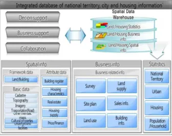
최근에는 계획, 사업시행, 개발, 판매 등 사업의 전 생애주기(business life cycle)에 활용되고 있는 공간정 보를 효과적으로 지원하기 위해 전사적 지리정보시스 템(Enterprise GIS)인 LH GIS-BANK를 구축하여 운영 하고 있다. LH GIS-BANK는 주요 업무를 지원하기
Figure 1. Integrated database of National territory, city, housing information in the SDW
LH business Utilization
Site analysis
∙ Review of urban master plan, Developable area analysis, Feasibiity analysis
Land Compensation
∙ Generation of parcel map, preparation of land report, land appraisal, investigation of illegal structure Urban
Regeneration
∙ Land and housing analysis of designated site, review on business index, project management
Social housing ∙ Understanding surrounding conditions of purchased rental housing
Land Banking ∙ Decision about purchasing on suggested land
Land and Housing Sales
∙ Promoting sales and providing information service to customers
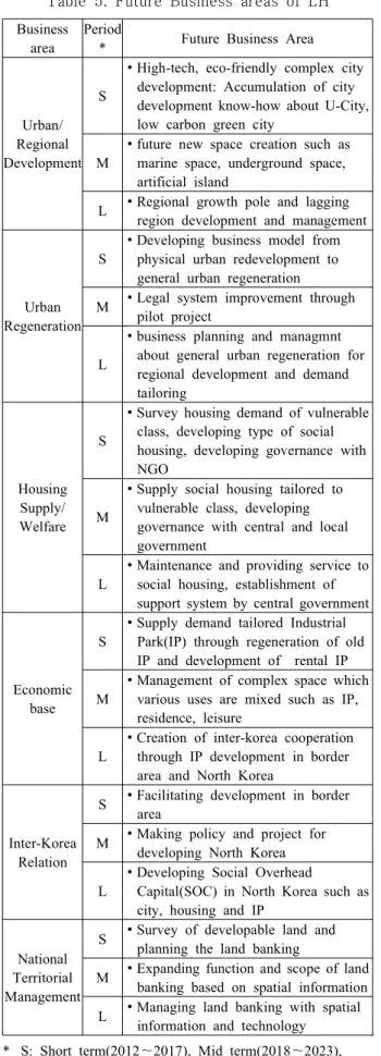
Table 4. Utilization of spatial information for LH
business
위한 6개의 하위시스템과 공간정보의 통합관리 및 내 부유통을 담당하는 공간데이터웨어하우스(Spatial Data Warehouse, SDW)로 구성되어 있다. SDW의 국토주 택도시통합정보는 공간정보, 사업정보, 정책정보로 구성되어 있으며, 6개 기관, 22개 시스템, 255개 자료 유형을 보유하고 있다(Fig. 1). 업무를 지원하기 위한 6개의 하위시스템은 현황파악, 사업성 지표 분석 등에 활용되고 있다(Table 4).
4.2 LH의 국토주택 미래사업 전망
LH는 과거, 현재 모습의 연장선상에서 미래를 구상 하기 위해서 사회문화적 변화가 정부, 시장 및 고객에 대한 사업영역과 경영을 바꾸는지를 전망해 보기 위 한 메가트렌드를 도출하여 미래사업의 전략방향을 도 출하였다[23]. 메가트렌드 분석은 국내외 기존연구, 연구진 토론, 전문가 초청강연을 통해 도출되었다. 사 업 분야는 도시 및 지역개발(Urban and Regional Development), 도시재생(Urban Regeneration), 주택공 급 및 주거복지(Housing Supply and Welfare), 경제기 반(Economic base), 남북협력(Inter-Korea Relation), 국토관리(National Territorial Management) 등 6개 분 야로 구분하였다. 각 영역에서의 변수는 도시 및 지역 개발에서는 기후변화 대응 및 IT기술이 접목된 녹색, 첨단도시 등 새로운 영역의 도시개발수요 증가, 도시 재생에서는 신구도시연계, 사회경제적 재생, 첨단복 합화 등에 따른 새로운 도시재생 수요 증가, 주택공급 및 주거복지에서는 1〜2인 가구 및 노인가구 증가, 삶 의 질 중시 문화 확산, 계층양극화 등 수요 특성의 다 양화 등이 제기되었다.
장래 전망을 위한 설문조사를 위해 「LHI 전략 리 포트」에서 도출한 미래 사업의 시기는 본 연구의 설 문에 적합하도록 설문시기부터 5년 단위로 단기, 중 기, 단기로 구분하였다. 이때 단기(S)는 2012년에서 2017년까지, 중기(M)는 2018년에서 2023년까지, 장 기(L)가 2024년에서 2029년까지로 구분하였다.
이를 통해서 표와 같이 6개 분야별 단기, 중기, 장기
로 총 18개의 사업유형으로 구분하였다(Table 5). 도
출된 미래 사업을 살펴보면 도시 및 지역개발에서 해
양, 지하 등 미래 신공간의 조성, 도시재생 및 주거복
지에서 맞춤형 공급, 경제기반에서는 복합공간의 관
리, 북한내 경제기반 및 SOC개발, 국토정보기술과 접
목한 토지비축기능 고도화 등이 있다. 이상의 미래 사
업에서 확인할 수 있는 바는 미이용 공간, 북한 등 국
토 신공간의 개발, 맞춤형 복합 개발, 국토정보의 활용
등을 들 수 있다. 이런 점에서 미래 국토개발을 위해서
는 공간정보 측면에서는 신규정보의 구축과 분석모형
의 개발이 요구됨을 확인할 수 있다.
Business area
Period
* Future Business Area
Urban/
Regional Development
S
∙ High-tech, eco-friendly complex city development: Accumulation of city development know-how about U-City, low carbon green city
M
∙ future new space creation such as marine space, underground space, artificial island
L ∙ Regional growth pole and lagging region development and management
Urban Regeneration
S
∙ Developing business model from physical urban redevelopment to general urban regeneration
M ∙ Legal system improvement through pilot project
L
∙ business planning and managmnt about general urban regeneration for regional development and demand tailoring
Housing Supply/
Welfare S
∙ Survey housing demand of vulnerable class, developing type of social housing, developing governance with NGO
M
∙ Supply social housing tailored to vulnerable class, developing governance with central and local government
L
∙ Maintenance and providing service to social housing, establishment of support system by central government
Economic base
S
∙ Supply demand tailored Industrial Park(IP) through regeneration of old IP and development of rental IP M
∙ Management of complex space which various uses are mixed such as IP, residence, leisure
L
∙ Creation of inter-korea cooperation through IP development in border area and North Korea
Inter-Korea Relation
S ∙ Facilitating development in border area
M ∙ Making policy and project for developing North Korea L
∙ Developing Social Overhead
Capital(SOC) in North Korea such as city, housing and IP
National Territorial Management
S ∙ Survey of developable land and planning the land banking
M ∙ Expanding function and scope of land banking based on spatial information L ∙ Managing land banking with spatial
information and technology
* S: Short term(2012~2017), Mid term(2018~2023), L:Long term(2024~2029)
** Source: LHI(2010)
Table 5. Future Business areas of LH 4.3 LH 미래사업의 융복합 공간정보 활용도 조사 본 조사에서는 2012년 9월 LH 내부의 국토, 주택, 도시, 남북협력, 산업단지 관련 부서 및 공간정보처에 서 업무에 7년에서 20년 이상 근무한 업무경험이 풍부 한 담당자를 대상으로 설문조사를 실시하였다. 이 가 운데 유효한 설문 25개를 대상으로 융복합 공간정보 의 활용도 조사결과를 평균하여 활용도를 전망하였 다. 설문에서는 “1점 전혀 활용되지 않음”에서 5점
“완전하게 활용” 사이의 값을 기재토록 하였고 평균 3 점 이상이면 업무에 활용될 수 있는 것으로 판단하였다.
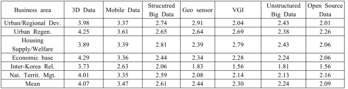
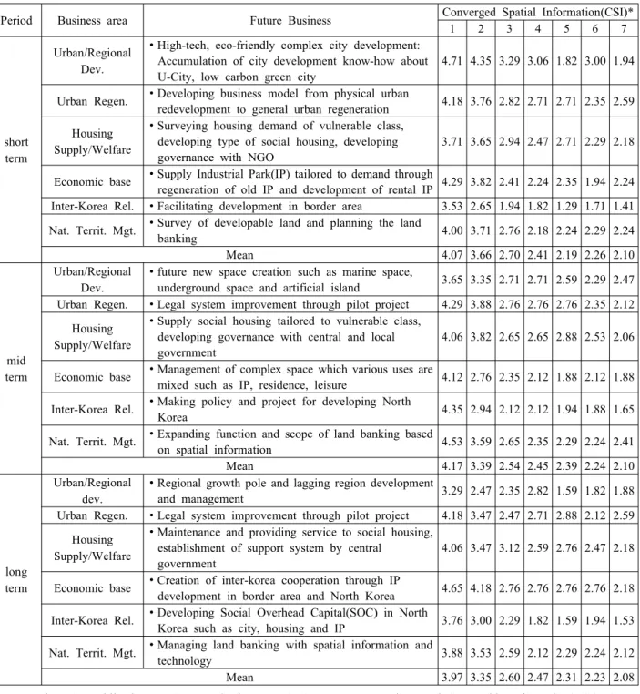
4.3.1 정보유형별/사업영역별 융복합 공간정보 활용도 융복합 공간정보별로는 3D 데이터가 4.07로 가장 높게 나타났으며, 모바일 데이터, 참여형 공간정보, 오 픈소스 데이터, 정형 빅데이터, 비정형 빅데이터, 지오 센서 순으로 활용도가 있는 것으로 나타났다. 이 가운 데 3D와 모바일 데이터는 평균 3점 이상으로 사업에 활용도가 있는 것으로 파악되었다(Table 6). 사업영역 별로는 3D 및 모바일 데이터 이외에 도시/지역개발에 서는 정형 빅데이터와 지오센서의 활용도가, 도시재 생에서는 오픈소스 데이터의 활용도가, 주택공급/주 거복지에서는 참여형 공간정보의 활용도가 상대적으 로 높은 것으로 나타났다. 도시/지역개발에서는 U-city 구축에 따른 빅데이터 및 센서 정보의 필요성이 제기 된 것으로 파악되며, 도시재생은 종합적 재생사업의 추진에 따라 공공정보 뿐만 아니라 민간정보의 필요 성이 제기되었으며, 주거복지에서는 지자체, NGO 등 의 참여에 따른 주민참여의 필요성에서 비롯된 것으 로 보인다. 또한 비정형 빅데이터의 경우에는 도시/지 역개발과 주택공급/주거복지에서 활용도가 상대적으 로 높은 것으로 나타났다. 이는 SNS 정보를 통한 부동 산 시장 심리동향, 지역별 주거복지 수요대상자 분석 등에 활용될 수 있는 것에 기인한 것으로 나타났다.
4.3.2 사업시기별/세부영역별 융복합 공간정보 활용도
사업시기별/세부영역별 활용도를 살펴보면 단기에
는 도시/지역개발에서는 첨단, 친환경, 복합도시개발
로 3D 데이터, 모바일 데이터, 정형 빅데이터, 지오센
서, 비정형 빅데이터의 활용도가 비교적 높다. 하지만
다른 사업에서는 3D 데이터와 모바일 데이터를 제외
하고는 활용도가 낮은 것으로 조사되었다. 중기에서
는 3D 데이터, 참여형 공간정보, 지오센서의 활용도는
증가한 반면 다른 정보의 수요는 낮아지는 것으로 나
타났다. 장기에는 정형 빅데이터, 지오센서의 활용도
는 증가한 반면 다른 정보의 활용도는 감소한 것으로
나타났다(Table 7).
Figure 2. Construction of Spatial Information for Balanced Territorial Use
Business area 3D Data Mobile Data StrucutredBig Data Geo sensor VGI Unstructured Big Data
Open Source Data
Urban/Regional Dev. 3.98 3.37 2.74 2.91 2.04 2.43 2.01
Urban Regen. 4.25 3.61 2.65 2.64 2.69 2.38 2.26
Housing
Supply/Welfare 3.89 3.39 2.81 2.39 2.79 2.43 2.06
Economic base 4.29 3.36 2.44 2.34 2.28 2.24 2.06
Inter-Korea Rel. 3.73 2.63 2.06 1.83 1.56 1.81 1.56
Nat. Territ. Mgt. 4.01 3.35 2.59 2.08 2.14 2.13 2.16
Mean 4.07 3.47 2.61 2.44 2.30 2.24 2.09
Table 6. Degree of utilization of converged geospatial information
4.4 미래 국토계획분야 활용 시사점
융복합 공간정보 활용도 분석에 따른 시사점을 활 용분야별로 살펴보면 다음과 같다. 먼저 도시 및 지역 개발 분야는 전통적으로 공간정보가 활발히 이용되던 분야로 본 분석에서도 다른 분야에 비해 융복합 공간 정보를 활발하게 활용할 수 있는 것으로 조사되었다.
6)그러나 설문조사에 나타난 바와 같이 실무자에게 있어 서 융복합 공간정보의 활용도는 3D 데이터, 모바일 데 이터 등 상용화된 정보에 국한되어 있음을 확인할 수 있었다. 따라서 다양한 융복합 정보의 활용이 이루어 지기 위해서는 해양, 지하 등 신공간에 적용하기 위한 구체적이고 실용적인 활용방법론이 필요할 것이다.
도시재생 분야는 도시 및 지역개발 다음으로 활용도 가 높을 것으로 나타난 분야이다. 정보단위에서는 도시
6) 대한국토도시계획학회에서 편찬한 “도시의 계획과 관리 를 위한 공간정보 활용 GIS”에서는 도시계획의 지원 및 관리측면에서 공간정보의 활용을 다루고 있다.
재생은 지역지구, 건물, 필지 단위의 진단과 평가를 위 한 도시재생 구역정보 기초의 도시재생공간정보와 건 물행정정보의 융복합이 요구되고 있다[24]. 특히 도시 재생을 미시적 관점에서 이해하고 분석하기 위해서는 BIM(Building Information Modeling)의 활용을 통해 물 리적 재생의 정보기반을 마련할 수 있다. 이러한 의미 에서 도시재생에서는 3D 데이터를 기반으로 이들 정보 가 결합된 정보 활용이 활발해짐과 더불어 참여형 공간 정보를 기반으로 한 주민참여 수법 개발이 요구되는 것으로 판단된다.
주택공급 및 주거복지 분야는 세밀한 인구현황 및 이동 분석은 핵심적이다. 그러므로 모바일 데이터를 이용한 현황분석 수요는 증가할 것이다. 하지만 이와 더불어 부동산 시장 심리동향 분석, 지역별 주거복지 수요대상 발굴을 위해 참여형 공간정보와 비정형 빅
데이터의 활용도 중요한 역할을 할 것으로 보인다.
산업단지, 경제자유구역을 건설하는 경제기반 분야
는 도시 및 지역개발과 유사한 활용 양상을 보이는
Period Business area Future Business Converged Spatial Information(CSI)*
1 2 3 4 5 6 7
short term
Urban/Regional Dev.
∙ High-tech, eco-friendly complex city development:
Accumulation of city development know-how about U-City, low carbon green city
4.71 4.35 3.29 3.06 1.82 3.00 1.94
Urban Regen. ∙ Developing business model from physical urban
redevelopment to general urban regeneration 4.18 3.76 2.82 2.71 2.71 2.35 2.59 Housing
Supply/Welfare
∙ Surveying housing demand of vulnerable class, developing type of social housing, developing governance with NGO
3.71 3.65 2.94 2.47 2.71 2.29 2.18
Economic base ∙ Supply Industrial Park(IP) tailored to demand through
regeneration of old IP and development of rental IP 4.29 3.82 2.41 2.24 2.35 1.94 2.24 Inter-Korea Rel. ∙ Facilitating development in border area 3.53 2.65 1.94 1.82 1.29 1.71 1.41 Nat. Territ. Mgt. ∙ Survey of developable land and planning the land
banking 4.00 3.71 2.76 2.18 2.24 2.29 2.24
Mean 4.07 3.66 2.70 2.41 2.19 2.26 2.10
mid term
Urban/Regional Dev.
∙ future new space creation such as marine space,
underground space and artificial island 3.65 3.35 2.71 2.71 2.59 2.29 2.47 Urban Regen. ∙ Legal system improvement through pilot project 4.29 3.88 2.76 2.76 2.76 2.35 2.12
Housing Supply/Welfare
∙ Supply social housing tailored to vulnerable class, developing governance with central and local government
4.06 3.82 2.65 2.65 2.88 2.53 2.06
Economic base ∙ Management of complex space which various uses are
mixed such as IP, residence, leisure 4.12 2.76 2.35 2.12 1.88 2.12 1.88 Inter-Korea Rel. ∙ Making policy and project for developing North
Korea 4.35 2.94 2.12 2.12 1.94 1.88 1.65
Nat. Territ. Mgt. ∙ Expanding function and scope of land banking based
on spatial information 4.53 3.59 2.65 2.35 2.29 2.24 2.41
Mean 4.17 3.39 2.54 2.45 2.39 2.24 2.10
long term
Urban/Regional dev.
∙ Regional growth pole and lagging region development
and management 3.29 2.47 2.35 2.82 1.59 1.82 1.88
Urban Regen. ∙ Legal system improvement through pilot project 4.18 3.47 2.47 2.71 2.88 2.12 2.59 Housing
Supply/Welfare
∙ Maintenance and providing service to social housing, establishment of support system by central
government
4.06 3.47 3.12 2.59 2.76 2.47 2.18
Economic base ∙ Creation of inter-korea cooperation through IP
development in border area and North Korea 4.65 4.18 2.76 2.76 2.76 2.76 2.18 Inter-Korea Rel. ∙ Developing Social Overhead Capital(SOC) in North
Korea such as city, housing and IP 3.76 3.00 2.29 1.82 1.59 1.94 1.53 Nat. Territ. Mgt. ∙ Managing land banking with spatial information and
technology 3.88 3.53 2.59 2.12 2.29 2.24 2.12
Mean 3.97 3.35 2.60 2.47 2.31 2.23 2.08
* 1. 3D data, 2. Mobile data, 3. Structured Big Data, 4. Geo-sensor, 5. Volunteered Geographic Information(VGI), 6.
Unstructured Big Data, 7. Open Source Data
Table 7. Degree of utilization of converged geospatial information by business area
분야로 융복합 공간정보의 활발한 활용이 가능한 분 야가 될 것이다. 남북협력에서는 접근불능지역이라는 제약성으로 활용가능한 정보가 원격탐사자료 등에 한 정되어 있다. 따라서 SNS 데이터를 활용하여 지명, 주요 산업시설 등 속성정보를 확보하는 방법론의 개 발이 필요하다. 국토관리에서는 국토이용 및 보전에 관한 자료 전반을 이용하는 토지수급관리를 위해 3D, 모바일 데이터의 적극적인 활용이 필요할 것이다.
5. 결 론
본 논문은 융복합 공간정보의 국토분야 활용 가능 성을 전망해 보기 위해 LH의 국토 및 주택과 관련된 미래 사업을 사례로 선정하여 활용도를 분석하였다.
이를 위해 계획에서의 정보수요 분석을 통해 융복합
공간정보를 도출하기 위한 계획단계별 공간정보 분석
및 활용사례 발굴을 제기하였다. 국토계획 활용을 위
해 3D 데이터, 모바일 데이터 등 7종의 융복합 공간정 보를 도출하였다. 분석대상인 LH의 미래 사업에서는 전통적인 택지개발, 주택공급 이외에 해양, 지하 등 신공간의 개발, 복합개발, 주거복지의 거버넌스 체계 강화 등이 제시되었다. 분석결과 LH의 미래 사업에서 는 3D 데이터와 모바일 데이터의 활용도가 높은 것으 로 나타났다. 또한 정형 빅데이터, 지오센서, 참여형 공간정보, 비정형 빅데이터와 같은 공공이 아닌 민간 이 구축한 데이터도 사업 분야에 따라서는 활용도가 있을 것으로 나타났다.
이상의 분석결과 다음과 같은 한계점과 시사점을 도출할 수 있었다. 연구의 한계점은 국토계획을 위한 사례로 LH를 대상으로 하였지만 토지주택에 관련된 사업을 집행하는 기관의 한계로 인하여 도시정보 피 라미드에서의 본 시행측면의 정보 활용에 집중되어 있고 관리 및 정책 측면의 활용분석은 미비하였다. 또 한 미래 사업에 대한 활용을 묻는 설문임에도 현재 적용 가능한 기술 활용도로 응답한 점은 향후 연구에 서는 조사방법의 개선이 필요한 것으로 나타났다.
반면 연구를 통한 시사점은 융복합 공간정보의 이 용을 위해서는 구체적이고 실용적인 방법론의 개발과 함께 새로운 계획기법이 모색되어야 한다는 점이다.
그리고 모바일 정보, 정형 빅데이터는 통신사, 카드사 등 기업이 보유한 민간정보이므로 민간기관의 정보 유통 및 공공기관의 활용 방안 마련이 선행되어야 할 것이다.
궁극적으로 현행 국토계획에서는 손쉽게 계획이 수 립되어 이용 가능한 미개발 토지에 초점이 맞추어졌 다. 이에 필요한 정보도 토지이용 공간정보(landuse spatial information)가 주류를 이루었다. 하지만 장래 에 국토 경쟁력 강화를 위한 융복합 공간정보 활용을 위해서는 토지 중심의 정보구축과 공간이용에서 벗어 나 해양, 연안, 지하 등 전국토를 대상으로 한 균형 있는 국토이용 공간정보(territorial use spatial in- formation)의 구축이 필요할 것이다. 뿐만 아니라 통일 을 대비하여 휴전선과 접한 접경지역 및 휴전선 이북 의 접근불능지역 공간정보 구축이 이루어져 한반도 전체를 대상으로 한 국토계획의 토대가 마련되어야 할 것이다(Fig. 2).
References
[ 1 ] Batty, M. 2012, Editorial: Smart Cities, big da- ta, Environment and Planning B: Planning and Design, 39:191-193.
[ 2 ] BBSR. 2003, Szenarien zur Raumentwicklung,
Raum - und Siedlungsstrukturen Deutschlands 2015/2040.(http://www.bbsr.bund.de)
[ 3 ] Camagni, R. 2002, On the Concept of Territorial Competitiveness: Sound or Misleading?, Urban Studies, 39(13):2395-2411.
[ 4 ] Cho, C. M; Chung, M. S. 2010, U-City Service Space Realization Strategies in Digital Convergence Era, Journal of Korea Spatial Information Society, 18(2):77-88.
[ 5 ] Cho, W. S. 2011, Book review: Geospatial Information Convergence is prerequisite for act- ing geospatial information policy, Monthly National Territory, 358:156-157.
[ 6 ] Choi, B. M; Kim, H. J; Seo, D. J. 2010, Urban Information and GIS, Daewangsa:Seoul.
[ 7 ] Choi, B. N; Lee, Y. J; Kong, H. K. 2010, A Study on Value Chain and Dynamic Effects of Geospatial Information Convergence, KRIHS.
[ 8 ] Choi, J. W. 2009, Urban Regeneration Information and Building Information Modeling, Seminar on the Smart Urban Renaissance based on the NSDI, KNHC.
[ 9 ] Choi, J. Y; Kim, T. G. 2012, A Study on the Construction of Housing Geospatial Information for the Integrated use of Housing Supply Model, Journal of Korea Spatial Information Society, 20(6):1-11.
[10] Cheshire, J; Batty, M. 2012, Editorial:
Visualization tools for understanding big data, Environment and Planning B: Planning and Design, 39: 413-415.
[11] DATAR. 2011, Territoires 2040.(http://www.datar.gouv.fr)
[12] DIACT. 2006, Territoires 2030.
[13] Drummond, W. J; Steve, P. F. 2008, The Future of GIS in Planning: Converging Technologies and Diverging Interests, Journal of the American Planning Association, 74(2):161-174.
[14] ESPON. 2007, Scenarios on the territorial future of Europe, ESPON(http://www.eson.eu).
[15] Haklay, M. 2010, How good is volunteered geo- graphic information? A comparative study of OpenStreetMap and Ordnance Survey datasets, Environment and Planning B: Planning and Design, 37:682-703.
[16] Heikkila, E. J. 1998, GIS is Dead; Long Live
GIS!, Journal of the American Planning
Association, 64(3):350-360.
[17] Hur, J. Y; Kim, D. J; Kim, M. S; Kang, M. G;
Park, J. H. 2012, Future Agenda and Policy Direction for National Territorial Development, KRIHS.
[18] Huxhold, W. E. 1991, An introduction to urban geographic information systems, Oxford uni- versity press.
[19] Kim, D. J; Lee, S. J; Lee, Y. W; Moon, J. H;
Lee, S. J; Nam, G. C; Park, J. H; Lee, G. M.
2012, Pioneering the future national territory and new balanced development strategy, KRIHS.
[20] Korea Planners' Association. 2010, GIS of spa- tial information utilization for urban planning and management, Bo-seong-gak.
[21] Land, S; Haase, D; Seppelt, R; Schwarz, N.
2012, Simulating demography and housing de- mand in an urban region scenarios of growth and shrinkage, Environment and Planning B:
Planning and Design, 39: 229-246.
[22] Land and Housing Research Institute(LHI).
2010, Megatrend and 2030 LH Grand vision, LHI.
[23] Land and Housing Research Institite. 2011, A study on the pilot system development for LH spatial information utilization, LHI.
[24] Lee, H. J. 2009, Development strategy for Urban Renaissance Informatization(URI), Seminar on the Smart Urban Renaissance based on the NSDI, LH.
[25] Lee, J. I; Kang, Y. O. 2005, A study on the es- tablishment and usage of urban land use in- formation system in Seoul, Seoul Development Institute.
[26] Lee, Y. W; Kim, S. H; Son, H. G; Kim, D. H;
Park, J. H; Im, J. Y. 2012, Future Prospect Strategies for National Territorial Development(I), KRIHS.
[27] LH. 2012, LH Sustainability Report 2012, LH.
[28] MLTM. 2011, Development of overseas ex- pansion consulting program for best practice case of national spatial information, MLTM.
[29] MLTM. 2012, Spatial Big Data Master Plan for envision the participatory government, MLTM.
[30] Reads, J; Calabresse, F; Ratti, C. 2009, Eigenplaces: analysing cities using the space-time structure of the mobile phone net- works, Environment and Planning B: Planning and Design, 36:824-836.
[31] Advanced search service in Dictionary of IT term(http://terms.naver.com).
논문접수:2013.06.05 수 정 일:2013.08.09 심사완료:2013.08.30