• 검색 결과가 없습니다.

IEG 환경지질연구정보센터

N/A
N/A
Protected

Academic year: 2021

Share "IEG 환경지질연구정보센터"

Copied!
4
0
0

로드 중.... (전체 텍스트 보기)

전체 글

(1)

Investigation of Arctic Sea Ice using Space-borne Polarimetric SAR data

Jin-Woo Kim

1

, Duk-jin Kim

1

, and Byong Jun Hwang

2

1 School of Earth and Environmental Sciences, Seoul National University, Seoul 151-742, Korea 2 Scottish Association for Marine Science, Dunstaffnage Marine Laboratory, Argyll, PA37 1Q1, UK

Abstract: Due to the geographical remoteness and extreme weather conditions of Arctic sea, remote sensing technology has been an attractive tool for monitoring changes in the Arctic environment such as sea ice extent and thickness. However, these environmental changes can be easily elusive to optical sensors, making visible spectrum data vulnerable to atmospheric conditions. Microwave remote sensing, particularly using synthetic aperture radar (SAR), has great potential for quantitative monitoring and mapping of sea ice changes. In this study, we investigated the spatial variation of sea ice thickness and ice-types using multi-frequency and polarimetric SAR data. TerraSAR-X (X-band) and ALOS PALSAR (L-band) were acquired over the study site off the sea of Northern Greenland and Alaska in 2009 and 2008. In-situ measurements were also carried out using electromagnetic induction sounding instrument (EM31) to obtain sea ice thickness and snow depth profiles.

Polarimetric analysis including target decomposition, eigenvalue analysis, and polarization ratio, were applied to find the relationship with the ice-type and sea ice thickness. The observed results were simulated and

verified with several numerical models – Integral Equation Method (IEM) and thermodynamic models.

1. Introduction

Recently, researches related with sea-ice are actively advanced. It is well known that sea-ice plays a very important role in terrestrial heat balance and global warming. The high albedo of sea-ice will be able to reflect the solar radiant energy outside the atmosphere of the earth. As the global temperature increases with increasing greenhouse effect and as sea-ice areas decrease gradually, the solar radiant energy which is absorbed in the earth may increase little by little. As a result, the global warming can be accelerated, and the probability of climate change occurring comes to be high. Therefore, sea-ice research is important.

The observation of sea-ice in the field is usually restrictive due to the geographical remoteness and extreme weather conditions. Recently, the researches of sea-ice using remote sensing data have been increased. While the environmental changes can be elusive to optical sensors frequently, microwave remote sensing, particularly using Synthetic Aperture Radar (SAR), is a promising tool for measuring the environmental changes. SAR sensors are not affected by atmospheric conditions and can obtain images day and night. Therefore, it can be useful tool for monitoring sea-ice.

In order to measure the amount of sea-ice, we should know the information of sea ice thickness.

Recently, many studies have been conducted to estimate the thickness of sea-ice using SAR data has been conducted. Several researchers have calculated the thickness of sea-ice using L-band and X-band Pi- SAR data in the sea of Okhotsk [Wakabayashi et al,

2004; Nakamura et al, 2005; Nakamura et al, 2006].

They calculated the thickness of sea-ice using Backscattering Coefficient Ratio (BCR) of HH and VV polarization which was obtained by L- and X- band SAR data. They compared the estimated sea-ice thickness from L- and X-band SAR data with the measured thickness of sea-ice. They found that the observed sea-ice thickness values agreed well with the estimated values of L-band SAR data than those of X-band SAR data.

They mainly calculated and compared the thickness of sea-ice for First Year Ice (FYI) (30~200cm) in the sea of Okhotsk. However, most of the sea-ice exists in the polar region and the type of sea-ice is various.

For these reasons, it is necessary to investigate the capability to apply Nakamura et al. [2005]’s methods in the polar region.

In this research, we applied Nakamura et al.

[2005]’s methods in the polar region using ALOS PALSAR (L-band) and TerraSAR-X (X-band) data.

However, we could not calculate the thickness of sea- ice using TerraSAR-X SAR data. In order to understand the reason, we used Integral Equation Method (IEM) and Sea-Ice Thermodynamic Model (SITM). We compared the backscattering coefficient and the polarimetric parameters with the observed thickness of sea-ice for seeking the interrelation between the thickness of sea-ice and X-band SAR data in the polar region.

2. Data

(2)

Figure 1. The sites of SAR data. (a) The site of ALOS PALSAR (2006/8/14) in the arctic ocean off Alaska’s northern coast. (b) The site of TerraSAR-X (1:

2009/5/02 , 2:2009/5/13) and the site of in-situ measurement (star) X-band SAR data in the polar region.

2.1SAR Data

We used the SAR data which observed sea-ice in the Arctic Ocean off Alaska’s northern coast and Greenland’s northern coast. The Alaska’s northern coast was observed by ALOS PALSAR in 2006/8/14 and the Greenland’s northern coast was observed by TerraSAR-X twice in 2009/05/02 and 2009/05/13 respectively (Figure 1). The specifications of SAR data are summarized in Table 1.

2.2 In-situ Data

Dunstaffnage Marine Laboratory observed the snow depth and the thickness of sea-ice using electro-magnetic induction sounding system (EM31) in the coast of Greenland in 2009/04/30 (Figure 1). This device is designed to measure the magnitude of the in-phase and quadrature components of the secondary electro-magnetic field induced in the ground by the instrument’s 9.8kHz transmitted electro-magnetic field [Geonics Ltd., 1984]. Since sea-ice is relatively transparent at this frequency, the response measured by the instrument is a strong function of its height above and the conductivity of the sea water. Therefore, an accurate measurement of the secondary electromagnetic field response and a full solution analysis of the using the numerical procedure of Anderson (1979) should give a good estimate of the instrument seawater distance or the thickness of sea-ice when the EM31 is resting on the ice [Kovacs, 1996].

3. Methods

3.1 ALOS PALSAR

ALOS/PALSAR TerraSAR-X Acquisition

Date/Time

2006.8.14/7:28:27 2006.8.14/7:28:36

2009.5.02/17:40:01 2009.5.13/10:09:56 Center

frequency

1.27GHz (L-band)

9.65GHz (X-band) Polarization HH/VV/HV/VH HH/VV(2009/5/02)

HH/HV(2009/5/13) Spatial

resolution 10m 3m

Table 1. The specification of SAR data.

The SAR data observed by ALOS PALSAR were acquired in fully polarimetric mode (HH, HV, VH, and VV). Therefore, we could apply the linear relation equation (Eq. 1) as shown in [Nakamura et al., 2005] to estimate the thickness of sea-ice in this region using L-band SAR data.

013 . 0 313 .

2 LVVLHH

band iforL

H = − r Eq. (1)

where r LVVLHH = the VV-HH BCR of the L-band However, there was no in-situ available data in this region, we compared the results of calculation with the sea-ice chart that provided by National Snow and Ice Data Center (NSIDC).

3.2TerraSAR-X

As we mentioned above, we could not estimate the thickness of sea-ice from TerraSAR-X data using the linear relation equation (Eq. 2)

011 . 0 222 .

2 XVVXHH

band iforX

H = − r Eq. (2)

where r XVVXHH = the VV-HH BCR of the X-band In order to know the reason, we used IEM and SITM. We also compared the backscattering coefficient and polarimetric parameters of TerraSAR- X data with the observed thickness of sea-ice in this region for understanding interrelation between the thickness of sea-ice and X-band SAR data.

4.Results

4.1ALOS PALSAR

Figure 3 illustrates the sea-ice chart acquired in NSIDC in 2006/08/14 and the thickness map of sea- ice which is generated by ALOS PALSAR data on the

(a) (b)

(1)

(2)

(3)

Figure 2. (a) Sea-ice chart of NSIDC (b) Sea-ice chart in the arctic ocean off Alaska’s northern coast ( blue box: the site of ALOSPALSAR) (c) The thickness estimated map of sea-ice using ALOS PALSAR.

same date.

In Figure 3(b), we could understand the distribution of sea-ice using egg chart in Figure 3(a). First, in the red region (1), there is the sea-ice in more 90% of total area. And more 90% of sea-ice in this region is FYI(30~70cm). The rest is New Ice(NI). In the red region (2), there is the sea-ice in about 90% of total area. And about 70% of sea-ice is FYI(30~70cm).

About 30% of sea-ice is Gray Ice(GI) Second, in the orange region (4), there is sea-ice in about 70% of total area. And about 30% of sea-ice is FYI(30~70cm). about 40% of sea-ice is GI(10~15cm).

Third, in the green region (3), there is sea-ice in about 20% of total area. About 10% of sea-ice is FYI(30~70cm) and about 10% of sea-ice is GI(10~15cm).

Through above results, we confirmed the thickness map of sea-ice (Figure 3(c)). However, the information given by the sea-ice chart is limited. So, we could not confirm exactly the thickness map of sea-ice. However, relative thickness changes are similar in Figure 3(b) and Figure 3(c). For example, In Figure 3(b), the sea-ice in the region 1 and 2 is thicker than the sea-ice in the region 3 and 4. And the sea-ice in the region 3 is thicker than the sea-ice in the region 4. And Figure 3(c) shows the similar patterns. Therefore, we could confirm that it is possible to calculate the thickness of sea-ice in the Arctic sea using L-band SAR data and the linear relation equation (Eq. 1).

4.2TerraSAR-X

4.2.1Numerical experiment

As you saw above, In X-band data, we could not

Figure 3. The result of simulation for IEM. Real line is X-band. Dot line is L-band. X-axis is rms height which means surface roughness. Y-axis is the backscattering coefficient [dB].

estimate the thickness of sea-ice using Eq. 2. We used IEM and SITM in order to find out the cause. First of all, we calculated the brine volume of sea-ice in this region using SITM [Cox and Weeks, 1983]. Then the dielectric constant of sea-ice is calculated by brine volume estimated [Vant et al, 1978]. And, we simulated how much the VV-HH BCR of L- and X- band SAR data is affected by the surface roughness.

In Figure 4, the BCR of L-band SAR data has almost the same value as regardless of surface roughness. On the other hand, the BCR of X-band SAR data is significantly affected by the surface roughness. Nakamura et al. [2005] assumed that the BCR is not affected by surface roughness. However, as you saw simulation results, the BCR of X-band is affected by the surface roughness as well as dielectric constant. Therefore we could not have estimated the thickness of sea-ice using TerraSAR-X SAR data.

4.2.2Backscattering coefficient and Polarimetric parameter

We could find in the above that the thickness of sea- ice can not be estimated by X-band SAR data using the BCR. We compared the backscattering coefficient and estimated Polarimetric parameters of X-band SAR data with the thickness observed by EM31 of sea-ice. As a result, Figure 4(a) and (b) illustrates the interrelation between the backscattering coefficient and the thickness of sea-ice. As you can see, they are not related linearly each other. However, when we compared the eigenvalue of the covariance matrix ([C2]) for HH-VV and HH-HV polarization SAR data (TerraSAR-X) with the observed sea-ice thickness, very good relationship was found.

In Figure 4(c) and (d), the moving average filtered the eigenvalue are linearly related with the thickness of sea-ice. Especially, the eigenvalue 2 of HH-VV polarization SAR data is deeply related with the thickness of sea-ice

(a) (b) (c)

1

2 3

4

1

2 3

4

(4)

p

Figure 4. (a) The relationship between the backscattering coefficient of HH polarization.

(TerraSAR-X 2009/5/02) and the thickness of sea-ice (b) The relationship between the backscattering coefficient of VV polarization. (TerraSAR-X 2009/5/02) (c) The relationship between the moving average filtered eigenvalue 1 of covariance matrix (HH/VV). (d) The relationship between the moving average filtered eigenvalue 2 of covariance matrix (HH/VV).

5.Conclusion

Sea-ice has an important role for global warming.

However, due to the geographical remoteness and extreme weather conditions of polar region, we have the limitation of field research. Recently, the researches of sea-ice have been increased using satellite data. Nakamura et al. [2005] estimated the thickness of FYI using SAR data. However, most of sea-ice exists in polar region and the type of sea-ice is various. Therefore we need to confirm that we can estimate the thickness of sea-ice using Nakamura’s method in polar region.

We estimated the thickness of sea-ice in the polar region using ALOS PALSAR and TerraSAR-X SAR data. In ALOSPAL data, we could not confirm exactly the result estimated due to no in-situ data.

However, we compared the result with sea-ice chart acquired by NSIDC. As a result, we could know the relative thickness changes in thickness estimated map of sea-ice. However, In TerraSAR-X data, we could not estimate the thickness of sea-ice using Nakamura’s methods due to the effect of surface roughness. But, we could know that the moving average filtered eigenvalue 2 of covariance matrix ([C2]) in HH-VV polarization SAR data is linearly related with the thickness of sea-ice.

Acknowledgments

This work was support by Satellite Information Application Support and Operation Program of Korea Aerospace Research Institute (KARI). This research was also supported by a grant (07KLSGC03) from Cutting-edge Urban Development - Korean Land Spatialization Research Project funded by Ministry of Land, transport and Maritime Affairs of Korean government. The TerraSAR-X data used in this study were provided by the DLR (German Aerospace Center) through the Announcement of Opportunity with Chansu Yang. The ALOS PALSAR data used in this study were provided by JAXA through the Research Agreement awarded to Duk-jin Kim (PI No.358).

Reference

Hiroyuki Wakabayashi, Takeshi Matsuoka and Kazuki Nakamura, 2004. Polarimetric Characteristics of Sea Ice in the Sea of Okhotsk Observed by Airborne L-Band SAR. IEEE Trans. Geosci. Remote Sens., Vol. 42(11), 2412-2425

Kazuki Nakamura, Hiroyuki Wakabayashi , Kazuhiro Naoki, Fumihiko Nishio, Toshifumi Moriyama, and Seiho Uratsuka, 2005.

Observation of Sea-Ice Thickness in the Sea of Okhotsk by Using Dual-Frequency and Fully Polarimetric Airborne SAR (Pi-SAR) Data. IEEE Trans. Geosci. Remote Sens., Vol.43(11), 2460-2469

Kazuki Nakamura, Hiroyuki Wakabayashi, Shotaro UTO, Kazuhiro NAOKI, Fumihiko NISHIO, and Seiho URATSUKA, 2006. Sea-ice thickness retrieval in the Sea of Okhotsk using dual- polarization SAR data. Annals of Glaciology, Vol. 44, 261-267

Cox, G.F.N. and W.F. Weeks, 1983. Equations for determining the gas and brine volumes in sea-ice samples. J. Glaci.,Vol.29(102), 306-316

M.R. Vant, R.O. Ramseier,and V. Makios, 1978. The complex- dielectric constant of sea ice at frequencies in the range 0.1-40 GHz. J. Appl. Phys. Vol.49(3), 1264-1280

Fung, A.K.,and K.S. Chen, 2004. An Update on the IEM Surface Backscattering Model. IEEE Geosci. Remote Sens. Letters, Vol 1(2), 75-77

Fung, A.K., Zongqian Li, and K.S. chen, 1992. Backscattering from a Randomly Rough Dielectric Surface. IEEE Trans. Geosci.

Remote Sens., Vol.30(2), 356 -369

Qin Li, Jiancheng shi, and K. S. chen, 2002. A Generalized Power Law Spectrum and its Applications to the Backscattering of Soil Surfaces Based on the Integral Equation Model. IEEE Trans.

Geosci. Remote Sens., Vol.40(2), 271- 280

Anderson, 1979. Computer programs; numerical integration of related Hankel transforms of orders 0 and 1 by adaptive digital filtering. Jounal of Geoscience Research, Vol44, 1287-1305

Kovacs, 1993. Comparison of axial double ball and uniaxial unconfined compression tests on freshwater and sea ice samples. In Proceedings of the 12

th

International Conference on Port and Ocean

Geonics, Ltd., 1984. Operating manual for EM-31-D non- contacting terrain conductivity meter, Geonics, Ltd., Toronto, Ontario, Canada

(a) (b)

(c) (d)

수치

Figure 1. The sites of SAR data. (a) The site of ALOS  PALSAR (2006/8/14) in the arctic ocean off Alaska’s  northern coast
Figure 3. The result of simulation for IEM. Real line  is X-band. Dot line is L-band. X-axis is rms height  which means surface roughness
Figure 4. (a) The relationship between the  backscattering coefficient of HH polarization

참조

관련 문서

Using the parameters above, a conformal transformation was applied to the control points extracted from the point cloud and the results were compared with the values in the

Using the polarimetric coherency matrix, the SAR data can be decomposed to three scattering mechanisms; that is, surface, double-bounce, and volume scatterings.. Later,

In this paper, we focused on the unsupervised classification results of the obtained GB-SAR images applying several polarimetric speckle filtering methods such as boxcar,

Then, the backscattering coefficients of various oil-layers are statistically obtained for N independent oil-spill surface samples using the Monte Carlo technique for various

In this study, we analyzed scattering characteristics of paddy rice obtained from an automatic scatterometer system and investigated the relationships between

GIST 다파장 Raman Lidar를 이용한 2005년 10월에 관측된 연무 현상의 광학적·미세물리적 특성 관측.. Measurement of Optical and Microphysical Parameters of

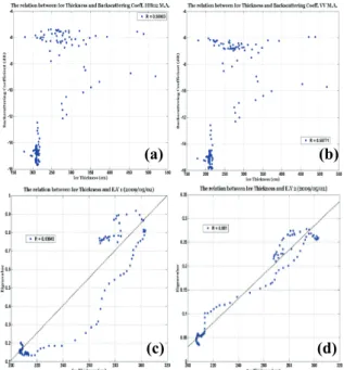
Backscattering coefficients of rice growth as a function of time at different wavelengths, incidence angles, and polarization.. 다(표

To evaluate the feasibility of this approach, we have studied about interrelation between geological boundary and density distribution, and corrected density distribution