• 검색 결과가 없습니다.

IEG 환경지질연구정보센터

N/A
N/A
Protected

Academic year: 2021

Share "IEG 환경지질연구정보센터"

Copied!
4
0
0

로드 중.... (전체 텍스트 보기)

전체 글

(1)

A STUDY ON ENCODING/DECODING TECHNIQUE OF SENSOR DATA FOR A MOBILE MAPPING SYSTEM

Sang Keun Bae

Master Course

Department of Geoinformatic Engineering, Inha University 253 Yonghyun-dong, Nam-gu, Incheon 402-751, Korea

Tel.: +82-32-865-5110, Fax: +82-32-863-1506, E-mail : [email protected]

Byung Guk Kim

Professor

Department of Geoinformatic Engineering, Inha University 253 Yonghyun-dong, Nam-gu, Incheon 402-751, Korea

Tel.: +82-32-860-7603, Fax: +82-32-863-1506, E-mail : [email protected]

ABSTRACT:

Mobile Mapping Systems using the vehicle equipped the GPS, IMU, CCD Cameras is the effective system for the management of the road facilities, update of the digital map, and etc. They must provide users with the sensor data which is acquired by Mobile Mapping Systems in real-time so that users can process what they want by using the latest data. But it’ s not an easy process because the amount of sensor data is very large, particularly image data to be transmitted. So it is necessary to reduce the amount of image data so that it is transmitted effectively. In this study, the effective method was suggested for the compression/decompression image data using the Wavelet Transformation and Huffman Coding. This technique will be possible to transmit of the geographic information effectively such as position data, attitude data, and image data acquired by Mobile Mapping Systems in the wireless internet environment when data is transmitted in real-time.

KEY WORDS: Mobile Mapping Systems, real-time, sensor data, Wavelet Transformation, Huffman Coding

1. BACKGROUND

The grasp of the present state for the construction or complement of the roads and road facilities is mostly conducted by using the topographic map or field inspection. These methods need to spend much time and cost. Moreover update of information is late and so it is not efficient to process the data. On the other hand Mobile Mapping Systems have the advantage of the efficient process for the data and it can control the interval of the data update. A Mobile Mapping System is an effective method to acquire the position and image data using vehicle equipped with the GPS(Global Positioning System), IMU(Inertial Measurement Unit), and CCD camera. Because the geographic information such as image data, position data, attitude data can offer the information about the object area, users can auquire the data without field survey. If the data which is acquired is transmitted to the users in real-time, the users can always use the latest data. But Mobile Mapping Systems can use not wire but wireless internet, so we consider the transmission speed, data volume, and etc in wireless internet situation. In this research, efficient transmission

method of geographic information is proposed for the Mobile Mapping System.

2. RESEARCH CHALLENGES

The following <Figure 1> shows the outline of this

research. The geographic information which is acquired

by Mobile Mapping Systems is transmitted to the

reference station by the wireless internet device in real-

time. This latest geographic information can be used to

analysis and process the data by users. Because the

volume of image data is large, it needs to compress the

data volume by using the encoding/decoding technique

for the efficient transmission. In this research, the method

which compress and decompress the image data by using

the Wavelet Transformation and Entropy Coding is

proposed for the effective transmission of data. Moreover

it is suggested that the position data which is acquired by

using the RTK GPS is transmitted to the reference station

by wireless internet in real-time. The following <Figure

2> expresses the summary of this research briefly.

(2)

Figure 1 Real-Time Transmission of geographic data for a Mobile Mapping System

Figure 2 The research for the wireless transmission of geographic information

3. ENCODING/DECODING OF THE IMAGE DATA The volume of image data which is acquired by Mobile Mapping Systems is much larger than positin data and attitude data. So the use of encoding/decoding technique is effective to transmit the image data. In this research, Wavelet Transformation and Entropy Coding is used to encode and decode the image data efficiently.

3.1 Wavelet Transformation

Wavelet techniques enable us to divide a complicated function into several simpler ones and study them separately. This property, along with fast wavelet algorithms, which are comparable in efficiency to fast Fourier Transform algorithms, makes these techniques very attractive in analysis and synthesis problems.

Different types of wavelets have been used as tools to solve problems in signal analysis, image analysis, medical diagnostics, boundary value problems, geophysical signal processing, statistical analysis, pattern recognition, and many others. While wavelets have gained popularity in these areas, new applications are continually being investigated. A reason for the popularity of wavelet is its effectiveness in representation of nonstationary(transient) signals. Since most of natural and human-made signals are transient in nature, different wavelets have been used to represent this much larger class of signals than Fourier representation of stationary signals. Unlike Fourier-based analyses that use global (nonlocal) sine and cosine functions as bases, wavelet analysis uses bases that are localized in time and frequency to represent nonstationary signals more effectively.

3.2 Entropy Coding

An Entropy Coding is a coding scheme that assigns codes to symbols so as to match code lengths with the probabilities of the symbols. Typically, entropy encoders are used to compress data by replacing symbols represented by equal-length codes with symbols represented by codes proportional to the negative logarithm of the probability. Therefore, the most common symbols use the shortest codes. Entropy Coding is urgently needed for very large medical or satellite images, both for reducing the storage requirements and for improving transmission efficiency. Three of the most common entropy coding techniques are Huffman Coding, Range Coding, and Arithmetic Coding. In this research, Huffman Coding is used to compress the image data.

3.3 Development of the software for Encoding/Decoding of image data

The software is developed to compress the image data which is obtained by the Mobile Mapping System using the Wavelet Transformation and Huffman Coding. A BMP image which has the size of 480×480 was used to test the developed software. Its volume is 231,478 bytes and it has the 8-bit gray level. The 2-level Wavelet Transformation is executed, and the image is compressed by using the Huffman Encoding. And then, the image is restored throughout the inverse process. The raw image is restored without loss of information by the Wavelet Transformation and Huffman Encoding/Decoding. When the image is compressed by Huffman Coding, the difference of compression efficiency between the images which is used or not used the Wavelet Transformation is very large. The volume of compressed image which is used the Wavelet Transformation is 42.85% of its original volume, but on the other hand the volume of compressed image which is not used the Wavelet Transformation is 93.38% of its original volume.

<Figure 3> shows the procedure of Wavelet Transformation for the sample image.

Figure 3 The procedure of Wavelet Transformation (Raw Image → 1-level transformation→ 2-level transformation

→ l-level inverse transformation → Raw Image)

(3)

4. WIRELESS INTERNET RTK-GPS

The DGPS technique is based on the use of two (or more) receivers, where one (stationary) reference or base receiver is located at a known point and the position of the (mostly moving) remote receiver is to be determined.

The known position of the reference receiver is used to calculate corrections to the GPS derived position or to the observed pseudoranges. Originally, relative positioning was only possible by postprocessing data.

But today, real-time data transfer which can be possible enables real-time computation of baseline vectors, and has led to the real-time kinematic(RTK) technique. If the position data which is acquired by the Mobile Mapping System must be transmitted to the reference station in real-time, it is necessary to use the RTK-GPS technique.

The correction data can be transmitted by radio link or wireless internet. The wireless internet technique is cheaper than radio link technique and it can be used wherever we can connection the internet. In this research, the wireless internet technique is used to transmit the correction data. The organization of wireless internet RTK-GPS system is shown by the Following <Figure 4>.

The laptop computer which is equipped wireless LAN card is used. The test is practiced in the area which can connect the internet service using the AP(Access Point).

Figure 4 The organization of wireless internet RTK-GPS system

4.1 Development of the software for wireless internet RTK-GPS

The software is classified the module which send and receive the correction data, and the module which receive and save the corrected position data.

Figure 5 The module of transmitting and receiving the correction data

Figure 6 The module of receiving and saving the corrected position data

<Figure 5> is the module which receives the RTCM data from base station and sends it to the rover by the wireless internet. This correction data is used to compute the precise position of rover, and computed position is saved by the module of <Figure 6>. The module of

<Figure 6> is installed both base and rover. Namely, the position of rover can be confirmed at both sites because this module can display the precise position of rover on the digital map in real-time.

4.2 Conclusions

In this research, the method for transmitting the geographic data which is acquired by Mobile Mapping Systems is suggested. The position data is transmitted by using the wireless internet RTK-GPS technique. The Wavelet Transformation and Huffman Coding are used to compress the image data. A test is practiced with laptop computer (equipped the wireless LAN card) in the area which can use the AP. If the AP is not installed in the object area, wireless internet can not be used for Mobile Mapping Systems. To overcome this defect, it is needed to study about the Mesh Network technique. Using the Mesh Network technique can connect the internet service by using not only the AP but also other clients which are connected the internet. If this technique is applied to access the internet, it is possible to link the internet without the AP. Also, the Mesh Network technique provides the stable connection in the moving vehicle. The image orientation technique has been used to determine the 3-D position of an object in the image. If using the GPS/INS system, the position of the object can be directly calculated without any processing that is the image orientation. This is called as the Direct Georeferencing. The Mesh Network and Direct Georeferencing technique will be easy to apply Mobile Mapping Systems. So it is expected to increase the use of geographic information which is obtained by Mobile Mapping Systems.

5. ACKNOWLEDGMENT

This Research was supported by the MIC(Ministry of

information and Communication), Korea, under the

ITRC(Information Technology Research Center) support

(4)

program supervised by the IITA(Institute of Information Technology Assessment).

References from Journals:

Erol, C.B, Guven, P, 2001. “Ionospheric total electron content measurements by analyzing GPS data of Ankara, Turkey, Antennas and Propagation Society International Symposium, IEEE, Vol. 3, pp. 129-132, July 2001.

Z. Xiang and Y. Lu, 1997. “An effective wavelet matrix transform approach for efficient solutions of electromagnetic integral equations”, IEEE Trans.

Antennas Propag., 45, pp.1332-1339.

References from Books:

Jeong Dong Hoon, 2004 . “A study on camera calibration and 3D positioning for land-based mobile mapping system”.

Park Sung Wan, 1996. “Image Compression and Restoration Using the Wavelet Transform”.

Lee Moon Su, 1998. “Lossless image compression using Wavelet transformation and auto adaptive block coding”

Y. Meyer and Ronald Coifman et al, 1992. “Wavelet and their applications”, JONES & BARTLETT PUBLISHERS.

Kim Jang Hyun, 2004. “A Study on Wireless Internet- Based RTK for in situation Geometric Correction of Satellite Imageries”.

B. Hofmann-Wellenhof, H. Lichtenegger, and J. Collins,

2001. “Global Positioning System Theory and Practice”,

5

th

edition, Springer Wien, NewYork.

수치

Figure 3 The procedure of Wavelet Transformation (Raw  Image → 1-level transformation→ 2-level transformation
Figure 5 The module of transmitting and receiving the  correction data

참조

관련 문서

For this analysis, we used Hyperion data acquired at July 3, 2001, the absolute atmospheric correction based MODTRAN model, and classified 25 classes using three

This contribution proposes the combined use of geophysical edge detection routines and ‘three point’ solutions from topographic data as a possible approach to obtaining

The model consists of the extinction coefficients and geo-referenced GIS data, thus the outputs including the near real-time Δ AOT vertical profile mapping and

In future, forest cover density mapping with object oriented classification method using QuickBird satellite data can be tried for entire India, so that not only the accuracy

Three processing strategies of seismic refraction data are tested in terms of velocity and depth profiles or struc- tures for mapping of geological discontinuities:

For this proposal, many mapping rules from GML application schema to spatial database schema were defined as well as suitable XML storage approaches for GML data ware selected.

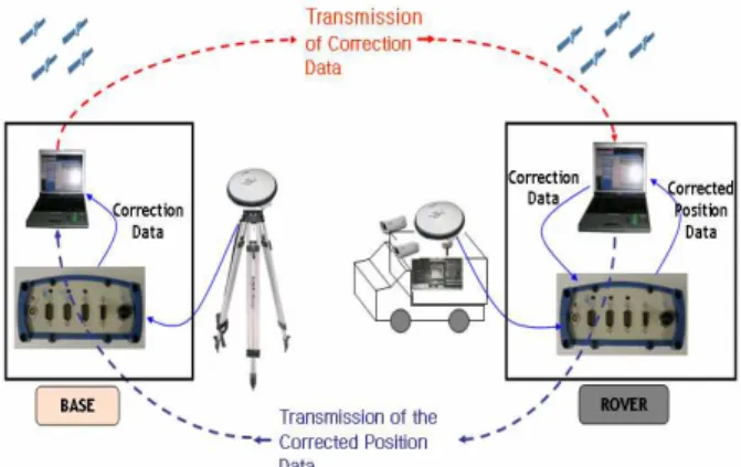
Both geophysical and geospatial data provide important information in the establishment of the optimal telecommunicat ion systems especially in the mobile telecommunication

This factor led to the initiation of a research project at the Remote Sensing &amp; GIS Laboratory, Kookm in University, to determine if multispectral data acquired by IKONOS