1
DESIGN AND IMPLEMENTATION OF MOVING OBJECTS MANAGEMENT SYSTEM APPLYING OPEN GOESPATIAL
DATA ENCODING
Hyejin Lee, Hyunah Lee, and Jongheung Park
Postal Technology Research Center, Electronics and Telecommunications Research Institute 161 Gajeong-dong Yuseong-gu, Daejeon 305-350, Korea
{hjin, halee, jpark}@etri.re.kr
ABSTRACT:
The Geography Markup Language (GML) is an XML encoding for the transport and storage of geographic information, including both the geometry and properties of geographic features. This paper uses the GML to provide extendibility and interoperability of spatial data in moving objects management system. Since the purpose of the system is to provide locations of the moving objects in the web and mobile environments, we used the GML both for presenting map data and trajectories of the moving objects.
The proposed system is composed of Location Data Interface, Moving Objects Engine, and Web/Mobile Presentation Interface. We utilized the concept of Web Map Server, that is web mapping technology of OGC (Open Geospatial Consortium), to integrate map data and the location information of the moving objects. In the process of the integration, we used the standard data model and interfaces while defining new application schema. Since our suggested system uses open spatial data encoding and interfaces, both extendibility and interoperability are guaranteed.
KEY WORDS: GIS, GML, Moving Object, Encoding
1. INTRODUCTION
The Geography Markup Language (GML) is an XML encoding for the transport and storage of geographic information, including both the geometry and properties of geographic features. This paper uses the GML to provide extendibility and interoperability of spatial data in moving objects management system. Since the purpose of the system is to provide locations of the moving objects in the web and mobile environments, we used the GML both for presenting map data and trajectories of the moving objects.
The proposed system is composed of Location Data Interface, Moving Objects Engine, and Web/Mobile Presentation Interface. We utilized the concept of Web Map Server, that is web mapping technology of OGC (Open Geospatial Consortium), to integrate map data and the location information of the moving objects. In the process of the integration, we used the standard data model and interfaces while defining new application schema. Since our suggested system uses open spatial data encoding and interfaces, both extendibility and interoperability are guaranteed.
The remainder of this paper is organized as follows. In section 2, the standard and the integration method of the OpenGIS are explained. In section 3, we suggest design of the structure of GML Application Schema. In section 4, design of Moving Object Management System, and in
section 5, implementation is presented. Finally, in section 6, we suggest conclusion of this paper.
2. RELATED WORKS
GML, that is standard specification of spatial data based on XML, is used as message format for synchronization. The research on GML started in May 2000 and reached current state through 3 years’ working.
In the early times, GML has been worked to encode geographic information by three organizations (Open Geospatial Consortium, ISO TC/211, Japan) [3, 4, 5]. In 2001, the work on GML 3.0 specification had been made since there were needs for standardization of geographic information encoding. GML 3.0 was published in 2003[6, 7].
3. STRUCTURE OF GML APPLICATION SCHEMA
First, target data should be analyzed to design application schema. It should be determined what meaning to give after the common elements are extracted from the data.
In the real process of modelling, UML which is standard modeling language is used. For example, if we design SungDong-Gu Schema, which is application schema, the relationship of SungDong-gu schema and GML schema is shown in figure 1.
2 Figure 1. Relationship of GML Object and Application
Schema
Figure 2 shows detailed design of SungDong-gu schema. SungDong-gu shape data are composed of two parts representing moving objects and spatial data.
Spatial data are composed of three types of spatial objects: Point, Line, and Polygon. Moving objects schema contains location of moving object, ID, trajectory, URL, etc.
Since any applications using XML based data can recognize and transmit the documents, the use of the document will be widespread. The message structure that will be exchanged between the server and the client is shown in figure 2.
Figure 2. SungDong-gu Schema
In this paper, topology relationships of spatial data are excluded for future work. We enable spatial operator between spatial data and moving object by using both spatial operator and Xlink method[6].
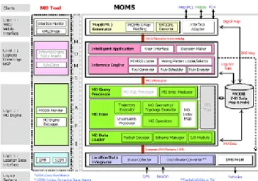
4. MOVING OBJECTS MANAGEMENT SYSTEM
The purpose of moving objects management system is to track real-time locations of moving objects and to present them on the map. Users can observe the locations
of moving objects on the web or PDA or etc. The whole system is shown below and composed of Location Data Interface, Mo Engine, MODB, and Web/Mobile Presentation Interface.
Figure 3. The Structure of Moving Objects Management System
The all steps of Web/Mobile Presentation Interface are shown below and divided into four steps.
Table 1. The steps of Web/Mobile Presentation Interface
Step Function Description
1
Input and translation of query
Requests from the user interface are translated into the form of queries and then transmitted to the server
2 Map
matching
Moving objects information is retrieved and the coordinates are matched to the map
3 Translation of format
The results of map matching are translated into the format of GML or Image.
4 Presentation The translated maps are displayed.
Request through user interface
Query Generation
Searching MOInfo
Map Matching Searching Map Coordinate Conversion
Determination of Target Map Region based on MOInfo
MODB
Generation of GML Application Schema Conversion to GML
Query Generation
Generation of GML Document
Interpretation through DOM Interface Conversion to SVG
Presentation MO MGR
Conversion to Image Request through user interface
Query Generation
Searching MOInfo
Map Matching Searching Map Coordinate Conversion
Determination of Target Map Region based on MOInfo
MODB
Generation of GML Application Schema Conversion to GML
Query Generation
Generation of GML Document
Interpretation through DOM Interface Conversion to SVG
Presentation MO MGR
Conversion to Image
3 Figure 4. The Flow of Web/Mobile Presentation Interface
4.1 Client
Web/Mobile Presentation Interface client provides a function to present both map and locations of moving objects simultaneously. Currently, three types of client devices are supported: cellular phone, PDA, and PC. The client devices are selected by the degree of user's mobility. Client modules are divided into three parts:
Query Input Module, DOM Interface, and Presentation of Query Results. Users can request the locations and properties of moving objects by query input module.
DOM Interface: In case of Web(PC), the vector data like SVG and GML are presented on the map by using DOM interface. In case of cellular phone and PDA, DOM interface is not used since image format is used for its proprietary browser.
Presentation of Query Results: Query results relevant to the car information, processed by MO Engine, are displayed in the form of texts and the map region containing the locations of the car is presented.
Web/Mobile Presentation Interface: The basic supported type is GML. It is converted into other types depending on the characteristic of the client.
Figure 5. Client Modules for Each Types of Devices
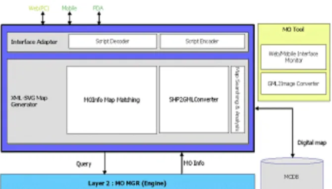
4.2 Server
Web/Mobile Presentation Interface is composed of two parts: Map Matching and Converter. Map Matching Part matches locations of moving objects and spatial data and Converter converts spatial data into GML.
Figure 6. Structure of Server Module
Server modules of Web/Mobile Presentation Interface are shown in figure 6. Server processes queries and matches the results with the map. Finally it combines locations of moving objects and map into GML.
Interface Adapter: provide encoding/decoding of transferring data between the client and the server. MO Engine provides a query language to search moving object information.
Script Encoder: Translated location information of GML format is converted to the data format which is understandable by the client device and then transmitted to the client.
Figure 7. Structure of Interface Adapter
Script Decoder: Script Decoder translates query data from mobile devices to the form understandable by MO Engine and then transmits to the MO Engine. The query result is transferred to the Map(GML) Generator.
Map(GML) Generator: Map Generator matches moving object information with map. Map is stored in MODB and searched area is translated to GML.
Figure 8. Structure of Map(GML) Generator
MOInfo Map Matching Module: MOInfo Map Matching analyzes locations of moving objects by using query result. It searches the map region in which moving objects exist. It has meta data about the format and area of map data of MODB and find map region based on meta data. It needs translation between the location of moving object and the coordinates of map data. The moving object information and map data are transmitted to SHP2GML Converter.
SHP2GML Converter: SHP2GML converts shape file to GML format. At the first step, it generates schema information based on original digital map data. At the second step, it generates GML data based on the generated schema.
4 Map Searching & Analysis: Map Searching & Analysis
searches map region of the moving object and analyzes schema of the map. Since the map can have different schema according to the format, schema analysis is necessary to translate to GML.
5. IMPLEMENTATION
Web implementation interface and PDA implementation interface are shown as follows.
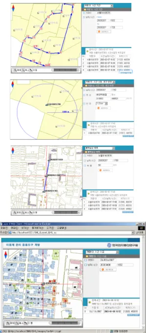
5.1 Web User Interface
Figure 9. Web User Interface
Web user interface is shown in figure 9 and divided into two parts: presentation region and query region.
Presentation region support general functions: zoom in, zoom out, and panning. Query region consists of query
input region and output region. It supports five classes of queries.
5.2 PDA User Interface
Figure 10. PDA Query Interface
PDA Query Interface is shown in figure 10. Since PDA has small presentation area than that of PC, it supports simplified form of user interface: pop up menu.
It operates on the internet explorer of PDA and uses html(JSP) and Image (server generated).
6. CONCLUSION
This paper suggested design and implementation of moving objects management system using GML. Since the proposed system uses data sharing and transmission of standard data format, interoperability can be guaranteed.
In the near future, GML will support SVG(Scalable Vector Graphics) which is standard graphic format of W3C and many researches are in progress[7]. Since GML3 added LBS related elements, it will be more appropriate for moving objects management system.
Thus, we will reflect GML3 and SVG in our system.
REFERENCES
[1] OpenGIS Consortium, Inc., Geography Markup Language(GML) 2.1.2, 2002
[2] OpenGIS Consortium, Inc., Web MapServer Interface Specification, Revision 1.1.1 2002 [3] ISO/TC 211, http://www.isotc211.org/
[4] G-XML, http://www.dpc.or.jp/
[5] OpenGIS Consortium, Inc., Geography Markup Language(GML) 3, 2003
[6] World Wide Web Consortium, Inc., XML Linking Language (XLink),
1999(http://www.w3c.org/TR/2000/WD-xlink- 20000221)
[7] World Wide Web Consortium, Inc. Scalable Vector Graphics(SVG),
2003(http://www.w3.org/TR/SVG11/)