Nat. Hazards Earth Syst. Sci., 13, 251–262, 2013 www.nat-hazards-earth-syst-sci.net/13/251/2013/ doi:10.5194/nhess-13-251-2013
© Author(s) 2013. CC Attribution 3.0 License.
EGU Journal Logos (RGB)
Advances in
Geosciences
Open Access
Natural Hazards
and Earth System
Sciences
Open AccessAnnales
Geophysicae
Open AccessNonlinear Processes
in Geophysics
Open AccessAtmospheric
Chemistry
and Physics
Open AccessAtmospheric
Chemistry
and Physics
Open Access DiscussionsAtmospheric
Measurement
Techniques
Open AccessAtmospheric
Measurement
Techniques
Open Access DiscussionsBiogeosciences
Open Access Open Access
Biogeosciences
DiscussionsClimate
of the Past
Open Access Open Access
Climate
of the Past
Discussions
Earth System
Dynamics
Open Access Open Access
Earth System
Dynamics
DiscussionsGeoscientific
Instrumentation
Methods and
Data Systems
Open Access
Geoscientific
Instrumentation
Methods and
Data Systems
Open Access DiscussionsGeoscientific
Model Development
Open Access Open Access
Geoscientific
Model Development
DiscussionsHydrology and
Earth System
Sciences
Open AccessHydrology and
Earth System
Sciences
Open Access DiscussionsOcean Science
Open Access Open Access
Ocean Science
DiscussionsSolid Earth
Open Access Open Access
Solid Earth
DiscussionsOpen Access Open Access
The Cryosphere
Natural Hazards
and Earth System
Sciences
Open Access
Discussions
Seismic risk assessment of architectural
heritages in Gyeongju considering local site effects
H.-J. Park1, D.-S. Kim1, and D.-M. Kim21Department of Civil and Environmental Engineering, Korea Advanced Institute of Science and Technology (KAIST), 291 Daehak-ro, Yuseong-gu, Daejeon, Korea
2Research Division of Architectural Heritage, National Research Institute of Cultural Heritage, Korea (NRICH), 132 Munji-ro, Yuseong-gu, Daejeon, Korea
Correspondence to: D.-S. Kim ([email protected])
Received: 3 January 2012 – Published in Nat. Hazards Earth Syst. Sci. Discuss.: – Revised: 9 October 2012 – Accepted: 1 December 2012 – Published: 8 February 2013
Abstract. A seismic risk assessment is conducted for cul-tural heritage sites in Gyeongju, the capital of Korea’s an-cient Silla Kingdom. Gyeongju, home to UNESCO World Heritage sites, contains remarkable artifacts of Korean Bud-dhist art. An extensive geotechnical survey including a series of in situ tests is presented, providing pertinent soil profiles for site response analyses on thirty cultural heritage sites. After the shear wave velocity profiles and dynamic material properties were obtained, site response analyses were car-ried out at each historical site and the amplification charac-teristics, site period, and response spectrum of the site were determined for the earthquake levels of 2400 yr and 1000 yr return periods based on the Korean seismic hazard map. Re-sponse spectrum and corresponding site coefficients obtained from site response analyses considering geologic conditions differ significantly from the current Korean seismic code. This study confirms the importance of site-specific ground response analyses considering local geological conditions. Results are given in the form of the spatial distribution of bedrock depth, site period, and site amplification coefficients, which are particularly valuable in the context of a seismic vulnerability study. This study presents the potential ampli-fication of hazard maps and provides primary data on the seismic risk assessment of each cultural heritage.
1 Introduction
Gyeongju, the capital of the ancient Silla Kingdom (57 BC ∼ 935 AD), is considered the most important historic city in Korea and contains remarkable artifacts of Korean
Buddhist art. Gyeongju is located in a relatively higher earth-quake prone region nearby the Yangsan fault line and has his-torical records of frequent seismic damage. In particular, the region’s valuable architectural heritages are exposed to seis-mic danger. A seisseis-mic risk assessment is therefore required to prevent damage to the area’s architectural heritages.
It has been well documented that local site effects may substantially affect amplification of ground motion with the dominant site period range, because earthquake motions at the bedrock can be drastically modified in amplitude, fre-quency content, and duration during the propagation of seis-mic waves within soil (Aki, 1993; Kim et al., 2002; Pitilakis, 2004; Sun et al., 2005; Chavez-Garcia, 2007). In the Korean seismic design code (MOCT, 1997), local site effects are con-sidered according to a site classification system and corre-sponding site coefficients, which are similar to the 1994 and 1997 NEHRP Provisions (BSSC, 1994, 1997), despite sub-stantial differences in local geological conditions. Kim and Yoon (2005) and Lee et al. (2012) showed significant devia-tions in response spectra between soil response analyses and code-defined values.
Rock-outcrop motions defined in the Korean seismic de-sign code correspond to seismic hazard maps developed for various return periods based on historical earthquake events based on the relation of ground motions to earthquake in-tensities. Because most of the historical events were not experienced at rock outcrops but rather at the ground sur-face of the soil sites and the effects of site amplification were already included in the historical earthquake intensi-ties, the rock-outcrop motion in the hazard map is poten-tially overestimated. In order to assess the extent of potential
Fig. 1. The satellite picture of Gyeongju historical areas, the location and foreground of typical cultural heritages.
overestimation in the hazard map, it is essential to evaluate the range of site amplification at various historical sites using a ground response analysis and interpret the spatial geotech-nical information, such as depth to bedrock, site period, and amplification characteristics, using a geographic information system (GIS).
In this study, site response analyses were performed at historical sites in Gyeongju to assess seismic risk. Thirty historical sites of cultural heritages were selected consider-ing importance and geographical distributions, and the repre-sentative shear wave velocity (Vs) profiles were determined by surface wave tests. One-dimensional site response anal-yses were carried out at each historical site and the ampli-fication characteristics, site period, and response spectrum of the site were determined. Amplification coefficients and the corresponding response spectra were compared with the coded values and the importance of a site-specific analysis for risk assessments was demonstrated. Sixty pre-existing soil datasets were gathered in the central area around a 7 km by 7 km area encompassing Gyeongju and ground response analyses were additionally performed. Necessary informa-tion for seismic risk assessment such as bedrock depth, site period, peak ground acceleration, and site amplification coef-ficients was spatially interpreted for the scenario earthquakes and the potential overestimation of rock-outcrop motion in a hazard map based on historical records was assessed. Seis-mic Seis-microzonation becomes particular valuable in the case of assessing the seismic vulnerability of historical monuments
and cultural heritages due to the case-dependent nature of their seismic performance.
2 Selection of test sites around Gyeongju historic areas Among the many cultural heritages in Gyeongju, cultural heritage sites with historical earthquake records and other na-tional architectural treasure sites were selected for site inves-tigation and ground response analysis. The UNESCO World Heritage sites selected for this study include “Seokguram Grotto and Bulguksa Temple”, “Gyeongju Historic Areas”, and “Yangdong Village”.
The Gyeongju Historic Areas host outstanding examples of Korean Buddhist art including sculptures, reliefs, pagodas, and the remains of temples and palaces from the period of the seventh to the tenth centuries, marking the culmination of this form of artistic expression. There are five major belts that make up the Gyeongju Historic Areas: the Mount Namsan Belt, the Wolseong Belt, the Tumuli Park Belt, the Hwangny-ongsa Belt, and the Fortress Belt, as shown in Fig. 1.
The historical data of earthquakes in the Gyeongju area are tabulated in Table 1 (NRICH, 2009). Notably, the cul-tural heritage sites that experienced damage to structures due to earthquake events include the “three storied stone pagoda at Bulguksa Temple (Site No. 2–2),” “Hwangnyongsa Tem-ple site (Site No. 6–1),” and “Mangdeoksa TemTem-ple site (Sites No. 7–1 and 7–2)”. Note that mountains and rock outcrops have relatively lower possibilities of local site amplification
Table 1. Historical records of seismic damage in Gyeongju. Month, Year Historical Records on the Earthquake for Gyeongju Inscribed
Korean Memory Classification of Memory in Korea Surface Geology (NRICH, 2009) Seismic Intensity (NRICH, 2009) Magnitude by Inference (NRICH, 2009) Potential Amplification (in this study)
Dec. 27 AD The ground shook and residences collapsed. ∼7–8 ∼5.0–6.0 ∼1.46–1.53 (Mean value of Gyeongju area) Jul. 89 AD The ground shook and cracked. Many people died
as residential homes collapsed.
∼8–9 ∼5.5–6.5 ∼1.46–1.53 (Mean value of Gyeongju area) Dec. 100 AD Residences collapsed and some people died after
ground shaking.
∼8–9 ∼5.0–6.5 ∼1.46–1.53 (Mean value of Gyeongju area) Oct. 304 AD Residences collapsed and some people died after
ground shaking.
∼8–9 ∼5.0–6.5 ∼1.46–1.53 (Mean value of Gyeongju area) Nov. 502 AD Residences collapsed and some people died after
ground shaking.
∼8–9 ∼5.0–6.5 ∼1.46–1.53 (Mean value of Gyeongju area) Jun. 510 AD Residences collapsed and some people died after
ground shaking. Samguksagi (History of Treasures No. 525, 722, 723 ∼8–9 ∼5.0–6.5 ∼1.46–1.53 (Mean value of Gyeongju area) Sep. 664 AD Residences collapsed after ground shaking.
The southern region was more severely affected.
the three kingdoms) ∼7–8 ∼5.5–6.0 ∼1.46–1.53 (Mean value of Gyeongju area) 775 AD The pagoda of Mangdeoksa Temple was shaken. Holocene,
Younger Alluvium
∼6–7 4.5 ∼1.66–1.81 (Site No. 7–1, 7–2)
Jun. 768 AD A great star fell at the southern region of Hwangnyongsa Temple.
An earthquake occurred and sounded like thunder.
Holocene, Younger Alluvium
6 4.5 ∼1.32–1.35 (Site No. 6–1)
779 AD The ground of Gyeongju shook.
Residences collapsed and one hundred people died.
∼8–9 ∼6.0–6.5 ∼1.46–1.53 (Mean value of Gyeongju area) Mar. 798 AD The two pagodas of Mangdeoksa Temple bumped
against each other.
Holocene, Younger Alluvium
∼6–7 4.5 ∼1.66–1.81 (Site No. 7–1, 7–2)
Jul. 804 AD The two pagodas of Mangdeoksa Temple bumped against each other.
Holocene, Younger Alluvium
∼6–7 4.5 ∼1.66–1.81 (Site No. 7–1, 7–2)
Jun. 1036 AD After a major earthquake around Gyeongju, a three storied stone pagoda at Bulguksa Temple was on the verge of collapse. Mukseojipyeon (Piece of ink on the paper) National Treasures No. 126–28 Biotite Granite ∼7–8 ∼5.5–6.5 ∼1.46–1.74 (Site No. 2–2)
Jul. 1036 AD The southern facilities of Bulguksa Temple collapsed.
The three storied stone pagoda at Bulguksa Temple on the verge of collapse.
Biotite Granite
∼7–8 ∼5.5–6.5 ∼1.46–1.74 (Site No. 2–2)
and seismic hazards. Therefore, cultural properties in moun-tain areas were excluded from this study. In this study, rock outcrops were considered as the reference point for the sur-vey. Four trig points of Mount Namsan (South Mountain), three trig points of the western area, and two trig points of the north-eastern area were used. Thirty cultural heritage sites in Gyeongju were selected for the in situ tests, as listed in Table 2.
In order to evaluate the GIS based seismic risk for the Gyeongju historic areas, a zone of 7 km by 7 km (Fig. 1), which includes the historic area and the current downtown area, was selected. Various pexisting site investigation re-sults in this zone were used as shown in the corresponding map of Fig. 7d (Kim et al., 2002; Sun et al., 2005). Sixty site characterization data, including the results of boring, standard penetration test, seismic tests, and laboratory tests were collected for this study. Figure 1 shows the location of Gyeongju historical areas and some representative cultural heritage sites.
3 Site characterization using in situ seismic tests A harmonic wavelet analysis of wave (HWAW) test, a kind of seismic surface wave test, was performed around the thirty
cultural heritage sites in order to measure the Vs profile of the site. In the “Cheomseongdae observatory (Site No. 1– 1)”, boring and downhole tests were executed to check the reliability of the HWAW method.
The HWAW test is a non-intrusive test that uses surface waves. It is based on the harmonic wavelet transform, which can be used to evaluate dispersive phases and group ve-locities of surface waves. Park and Kim (2001) proposed a step by step procedure of the HWAW method. After source generation with sledge hammer, the harmonic wavelet trans-form decomposes, the signals obtained at receivers 1 and 2 into frequency components in the time domain. This trans-form determines the energy and phase time-frequency maps, which describe the instantaneous energy and phase of the fre-quency components with time. The group and phase delays of each frequency component are determined from the in-stantaneous energy and phase information. The group delay refers to time corresponding to the maximum energy and the phase delay is the time corresponding to a certain fixed phase around the maximum energy time. If the distance between re-ceiver 1 and rere-ceiver 2 is known, then the group velocity and the phase velocity at each frequency can be obtained. The HWAW method uses the signal portion of the maximum lo-cal signal/noise ratio to evaluate the phase velocity. This can
Table 2. Cultural heritage sites for in situ test and ground response analysis in Gyeongju.
Classification Site
No.
Cultural Heritage Sites Classification in Korea
UNESCO World Heritage Sites
2–1 Dabotap Pagoda of Bulguksa Temple National Treasures No. 20
Seokguram Grotto and Bulguksa Temple (Inscribed in Dec. 1995)
2–2 Three storied stone pagoda at Bulguksa Temple
National Treasures No. 21
2–3 Yeonhwagyo and Chilbogyo bridges of Bulguksa Temple
National Treasures No. 22
2–4 Cheongungyo and Baegungyo bridges of Bulguksa Temple
National Treasures No. 23
2–5 Sarira Pagoda of Bulguksa Temple Treasures No. 61
Gyeongju Historic Areas (Inscribed in Dec. 2000)
3–1 Najeong Well in Gyeongju Historic Sites No. 245
The Mount Namsan Belt
3–2 Standing stone buddhist triad in Bae-dong
Treasures No. 63
3–3 Poseokjeong Pavilion site Historic Sites No. 1 7–4 Seochulji Lake Historic Sites No. 138 7–3 Three storied stone pagoda in
Namsan-ri
Treasures No. 124
The Wolseong Belt
1–1 Cheomseongdae observatory National Treasures No. 31 4–1 Gyerim Forest in Gyeongju Historic Sites No. 19 4–2 Wolseong Fortress Historic Sites No. 16 4–3 Imhaejeon Hall site Historic Sites No. 18 The Tumuli Park Belt 5–15–2 Royal tomb of King Michu of SillaJaemaejeong well Historic Sites No. 175Historic Sites No. 246
The Hwangnyongsa Belt 6–1 Hwangnyongsa Temple site Historic Sites No. 6 6–2 Stone pagoda of Bunhwangsa Temple National Treasures No. 30 The Fortress Belt 6–4 Myeonghwalsanseong Fortress Historic Sites No. 47 Yangdong Village (Inscribed in
July 2010)
8–0 Yangdong Village of Wolseong Important Folklore Materials No.189 8–1 Gwangajeong Treasures No. 442
8–2 Hyangdan Treasures No. 412
Cultural Heritage Sites with Earthquake Records
7–1 Mangdeoksa Temple site Historic Sites No. 7 7–2 Flagpole support of in Mangdeoksa
Temple site
Treasures No. 69
Other National Architectural Treasure Sites
9–1 Monument of King Taejongmuyeol of Silla Period
National Treasures No. 25
4–4 Three storied stone pagoda of Goseonsa Temple site, Gyeongju National Mu-seum
National Treasures No. 38
6–3 Three storied stone pagoda in Guhwang-dong
National Treasures No. 37
10–1 Five storied stone pagoda in Nawon-ri, Wolseong
National Treasures No. 39
11–1 Thirteen storied stone pagoda of Jeonghyesa Temple site
National Treasures No. 40
12–1 Three storied stone pagoda of Gameunsa Temple site
National Treasures No. 112
minimize the effects of noise. For the site characterization, the HWAW method generally uses a short receiver spacing setup. The source-receiver spacing (D) is ∼ 6–12 m and the receiver spacing (R) is ∼ 1–3 m. Because the HWAW method uses a short receiver spacing setup, it can minimize the possi-bility of error due to lateral non-homogeneity and can be used to determine a more detailed local soil profile as compared to the conventional SASW method (Park and Kim, 2001).
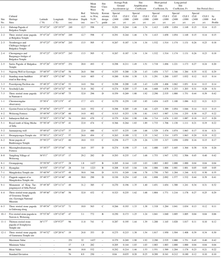
Twenty-eight HWAW tests, fourteen SASW tests, a bor-ing investigation, and a downhole test were conducted in thirty cultural heritage sites of Gyeongju. Figure 2 shows the thirty Vs profiles based on the in situ seismic tests. The site conditions can be characterized into six categories according to the mean shear wave velocity of the upper 30 m (Vs30), as suggested in the Korean seismic design code. Most of the ground in Gyeongju was found to be SC(very stiff soil
of soft rock; 360< Vs 30 ≤ 760), and others as SB (rock; 760< Vs 30 ≤ 1500) or SD(stiff soil; 180< Vs 30 ≤ 360).
4 Local site effects
4.1 Design rock-outcrop motion
Even though an earthquake resistant design code for the cultural heritage sites has not yet been proposed in Korea, considering the importance of a ripple effect on the col-lapse of the architectural heritage sites, the design rock-outcropping acceleration is considered for special structures and/or seismic class I structures at a collapse level earthquake in this study. The design rock-outcropping accelerations at Gyeongju were 0.20 g for the special structures (2400 yr re-turn period) and 0.14 g for seismic class I structures (1000 yr return period) at a collapse level earthquake based on the Korean seismic hazard map.
4.2 Dynamic soil properties and input ground motions Since ground motion is significantly affected by local site ef-fects, the compositions of the entire soil strata, determined by individual boring and seismic investigations, were sepa-rately utilized in the analyses. For the site-specific ground response analyses, thirty sets of in situ test results around cultural heritages and the sixty sets of pre-existing data were used. The sixty pre-existing datasets were composed of forty-four boring investigations, forty-four crosshole tests, twelve down-hole tests, and twenty-six SASW tests.
Input soil properties, such as Vs profile, mass density, and modulus reduction and damping curves, were determined for each layer. The bedrock locations where Vs were higher than 760 m s−1 were determined from seismic tests. As shown by the pre-existing site investigation results for Gyeongju, most soil layers were alluvial soils classified as either sand or gravel, such as GP, GM, SP, SW, and SM, in the unified soil classification system (Kim et al., 2002). The normalized shear moduli (G/Gmax) and damping ratios (D) with shear strain for the alluvial and weathered residual soils were deter-mined by resonant column tests with reconstituted specimens considering in situ conditions. Figure 3 shows the representa-tive normalized shear modulus reduction and damping curves of each alluvial and weathered residual soil for the ground re-sponse analysis. In the case of gravel and weathered rock, the corresponding G/Gmaxand damping curves in the literature were used (Schnabel et al., 1972; Seed et al., 1986).
One artificial synthetic earthquake, three strong motion recordings and one weak motion recording were used as input ground motions. The input rock-outcropping acceler-ations were modified to the levels of collapse level earth-quakes. Among the input motions, three strong motion recordings, El Centro, Hachinohe, and Ofunato earthquake motions, which were recorded in strong seismic regions, were included due to the lack of strong motion records
of earthquakes in Korea. To reflect the characteristics of regional seismicity, an earthquake acceleration waveform recorded in Gyeongju was also applied to derive site response data.
4.3 One-dimensional site response analysis
Site response analyses of Gyeongju were performed by using a one-dimensional equivalent linear scheme of the SHAKE program (Schnabel et al., 1972). This equivalent linear anal-ysis provides relatively reliable results when the strain level caused by an earthquake is lower than one percent, which is a typical range in moderate seismic zones such as Gyeongju (Kim et al., 2002). Through the equivalent linear analysis, more precise natural period value and amplification charac-teristics considering nonlinearity of soil deposits could be ob-tained at each site.
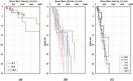
Figure 4 summarizes heritage information, in situ test re-sults, and site-specific ground response analysis results for the “Cheomseongdae observatory (Site No. 1–1)”. Cheom-seongdae, an astronomical observatory, was estimated to have been built in the period of Queen Seondeok (∼ AD 632– 647) in the Silla Era. It is highly valued as the oldest astro-nomical observatory in Asia. The representative shear wave velocity, the mean value of downhole and HWAW test re-sults, was used for the site response analysis of the Cheom-seongdae ground.
In the case of Cheomseongdae, the peak ground acceler-ations were 0.370 g for the earthquake level of a 2400 yr re-turn period and 0.259 g for the earthquake level of a 1000 yr return period. Depending on the local site effects, a maxi-mum of 1.85 times site amplification is expected. Notably, the deep alluvial layers, which are common in the Gyeongju area, show high potential for amplification. The site periods of the Cheomseongdae ground are ∼ 0.21–0.23 s.
The cultural heritage information, in situ test results, and site-specific analysis results for thirty heritage sites are sum-marized in the same manner as in Fig. 4. The site informa-tion, the Vs30, peak ground accelerations, site coefficient, and site periods were determined at thirty heritage sites, and are tabulated in Table 3. Site amplification coefficients are listed in the last column of Table 1.
Considering the maximum acceleration amplification be-tween rock-outcrop motion and free surface motion for the thirty cultural heritage sites, the “three storied stone pagoda in Namsan-ri (Site No. 7–3)”, the “Cheomseong-dae observatory (Site No. 1–1)”, and the “flagpole support of in Mangdeoksa Temple site (Site No. 7–2)” were ex-pected to have more than 1.5 times site amplification. On the contrary, “Gwangajeong (Site No. 8–1)” and “Hyangdan (Site No. 8–2)” in Yangdong Village, the “five storied stone pagoda in Nawon-ri (Site No. 10–1), Wolseong”, the “stand-ing stone Buddhist triad in Bae-dong (Site No. 3–2)”, and the “stone pagoda of Bunhwangsa Temple (Site No. 6–2)” had relatively low site amplification.
Table 3. The results of site-specific ground response analysis for cultural heritage sites.
Mean Site Average Peak Site Short-period Long-period Shear Class Ground Amplification Site Site
Wave by Acceleration (g) Coefficient Coefficient, Fa Coefficient, Fv Site Period (Sec) Bed Velocity Korean Special Special Special Special Special Cultural rock to 30 m, seismic CLE CLE I CLE CLE I CLE CLE I CLE CLE I CLE CLE I by Site Heritage Latitude Longitude Elevation Depth Vs30 design (2400 (1000 (2400 (1000 (2400 (1000 (2400 (1000 (2400 (1000 Soil No. Sites (◦N) (◦E) (m) (m) (m s−1) guide yr) yr) yr) yr) yr) yr) yr) yr) yr) yr) Profile
2–1 Dabotap Pagoda of Bulguksa Temple
35◦4702400 129◦1905700 249 12.7 598 C 0.291 0.244 1.46 1.74 1.413 1.658 1.054 1.148 0.15 0.14 0.15
2–2 Three storied stone pagoda at Bulguksa Temple 35◦4702400 129◦1905600 249 12.7 598 C 0.291 0.244 1.46 1.74 1.413 1.658 1.054 1.148 0.15 0.14 0.15 2–3 Yeonhwagyo and Chilbogyo bridges of Bulguksa Temple 35◦4702300 129◦1905600 243 13.5 505 C 0.267 0.187 1.34 1.34 1.532 1.514 1.174 1.131 0.26 0.23 0.18 2–4 Cheongungyo and Baegungyo bridges of Bulguksa Temple 35◦4702300 129◦1905700 243 13.5 505 C 0.267 0.187 1.34 1.34 1.532 1.514 1.174 1.131 0.26 0.23 0.18
2–5 Sarira Pagoda of Bulguksa Temple
35◦4702600 129◦1905500 251 20.0 493 C 0.298 0.211 1.49 1.51 1.718 1.696 1.221 1.173 0.27 0.24 0.20
3–1 Najeong Well in Gyeongju 35◦4805500 129◦1204600 56 26.0 386 C 0.255 0.200 1.28 1.43 1.654 1.717 1.346 1.284 0.35 0.32 0.29 3–2 Standing stone buddhist
triad in Bae-dong
35◦480500 129◦1204000 74 14.0 603 C 0.260 0.184 1.30 1.31 1.291 1.260 1.037 1.032 0.12 0.13 0.14
3–3 Poseokjeong Pavilion site 35◦4802500 129◦1204600 53 14.0 584 C 0.298 0.200 1.49 1.43 1.438 1.406 1.062 1.051 0.14 0.13 0.14 7–4 Seochulji Lake 35◦4704500 129◦1403200 95 31.0 382 C 0.274 0.205 1.37 1.46 1.668 1.678 1.253 1.203 0.31 0.28 0.31 7–3 Three storied stone pagoda
in Namsan-ri
35◦4703500 129◦1404000 75 32.0 296 D 0.359 0.269 1.80 1.92 2.290 2.535 1.880 1.751 0.44 0.39 0.42
1–1 Cheomseongdae observatory
35◦500400 129◦130900 47 17.7 431 C 0.370 0.259 1.85 1.85 1.654 1.635 1.100 1.086 0.22 0.21 0.23
4–1 Gyerim Forest in Gyeongju 35◦4905600 129◦130700 45 14.0 552 C 0.298 0.205 1.49 1.46 1.425 1.389 1.054 1.046 0.14 0.13 0.15 4–2 Wolseong Fortress 35◦4905900 129◦1302800 60 14.0 402 C 0.315 0.253 1.58 1.81 1.913 1.987 1.316 1.255 0.30 0.27 0.22 4–3 Imhaejeon Hall site 35◦500300 129◦1303600 56 18.0 470 C 0.379 0.261 1.90 1.86 1.714 1.676 1.103 1.087 0.18 0.17 0.20 5–1 Royal tomb of King Michu
of Silla
35◦5001800 129◦1203900 41 22.0 474 C 0.366 0.264 1.83 1.89 1.733 1.706 1.130 1.111 0.21 0.19 0.22
5–2 Jaemaejeong well 35◦4904300 129◦1204700 37 22.0 480 C 0.337 0.235 1.69 1.68 1.529 1.476 1.074 1.063 0.17 0.16 0.21 6–1 Hwangnyongsa Temple site 35◦5001100 129◦140200 57 26.0 494 C 0.263 0.189 1.32 1.35 1.342 1.314 1.075 1.063 0.20 0.19 0.22 6–2 Stone pagoda of Bunhwangsa Temple 35◦5002700 129◦140200 60 18.0 533 C 0.258 0.177 1.29 1.26 1.335 1.317 1.058 1.050 0.16 0.15 0.17 6–4 Myeonghwalsanseong Fortress 35◦3003700 129◦1504400 92 16.0 357 D 0.274 0.198 1.37 1.41 1.680 1.837 1.445 1.364 0.38 0.34 0.26 8–0 Yangdong Village of Wolseong 36◦00100 129◦1501500 17 29.2 282 D 0.293 0.235 1.47 1.68 1.753 1.947 1.552 1.506 0.45 0.40 0.42 8–1 Gwangajeong 35◦5905900 129◦150700 28 1.8 1437 B 0.205 0.144 1.03 1.03 1.003 1.003 1.000 1.000 0.04 0.04 0.04 8–2 Hyangdan 36◦00000 129◦1501000 28 3.0 1223 B 0.208 0.145 1.04 1.04 1.006 1.006 1.001 1.001 0.05 0.05 0.05 7–1 Mangdeoksa Temple site 35◦4805900 129◦1403700 49 30.0 346 D 0.331 0.249 1.66 1.78 1.750 1.783 1.284 1.246 0.32 0.30 0.35 7–2 Flagpole support of in
Mangdeoksa Temple site
35◦4805700 129◦1404000 48 30.0 290 D 0.330 0.254 1.65 1.81 1.898 2.092 1.577 1.532 0.44 0.39 0.41
9–1 Monument of King Tae-jongmuyeol of Silla Period
35◦4903000 129◦1101100 49 31.2 385 C 0.270 0.196 1.35 1.40 1.651 1.654 1.300 1.241 0.34 0.31 0.32
4–4 Three storied stone pagoda of Goseonsa Temple site, Gyeongju National Museum
35◦4904600 129◦1304600 56 32.0 432 C 0.323 0.235 1.62 1.68 1.804 1.771 1.216 1.178 0.27 0.25 0.29
6–3 Three storied stone pagoda in Guhwang-dong
35◦4905400 129◦1403300 71 10.0 563 C 0.266 0.193 1.33 1.38 1.318 1.284 1.041 1.034 0.13 0.12 0.11
10–1 Five storied stone pagoda in Nawon-ri, Wolseong
35◦5303600 129◦1204500 47 3.1 772 B 0.250 0.173 1.25 1.24 1.041 1.040 1.005 1.005 0.04 0.04 0.06
11–1 Thirteen storied stone pagoda of Jeonghyesa Temple site
36◦10700 129◦902700 96 11.8 741 C 0.287 0.195 1.44 1.39 1.200 1.165 1.020 1.017 0.11 0.10 0.12
12–1 Three storied stone pagoda of Gameunsa Temple site
35◦4405200 129◦2804100 19 24.8 353 D 0.275 0.215 1.38 1.54 1.817 1.950 1.504 1.408 0.39 0.34 0.30
Maximum Value – – 251 32 1437 – 0.379 0.269 1.90 1.92 2.290 2.535 1.880 1.751 0.45 0.40 0.42 Minimum Value – – 17 1.8 282 – 0.205 0.144 1.03 1.03 1.003 1.003 1.000 1.000 0.04 0.04 0.04 Mean Value – – 86 18.8 532 – 0.292 0.214 1.46 1.53 1.551 1.589 1.204 1.178 0.23 0.21 0.22 Standard Deviation – – 76 8.9 250 – 0.04 0.035 0.20 0.25 0.289 0.341 0.212 0.180 0.12 0.10 0.10
Fig. 2. Vs profiles around cultural heritage sites in Gyeongju; (a) site class B-3 sites, (b) site class C-21 sites, (c) site class D-6 sites.
Fig. 3. Normalized shear modulus reduction and damping curves for site response analysis of Gyeongju.
The site amplification coefficient, which is the ratio of peak ground surface acceleration to peak bedrock acceler-ation, ranges between 1.03 and 1.92. The mean value of the site amplification coefficient is 1.46 for the earthquake level of a 2400 yr return period and 1.53 for the earthquake level of a 1000 yr return period. Therefore, the current hazard map for the Gyeongju area has potential for site amplification of 1.5 times on average. It is necessary to reflect the potential amplification in the seismic hazard map in the future. 4.4 Korean seismic design code and site-specific ground
response analysis
As the depth of bedrock in Korea is generally shallow, the natural site period of Korea is distributed in the short-period range of 0.1 to 0.5 s. Since site effects are directly dependent on the local site effects, the use of site coefficients derived
from earthquake records for quakes that occurred in differ-ent site conditions may lead to inaccurate estimation of the earthquake ground motion.
As aforementioned, the current seismic design code of Ko-rea uses the site classification system and corresponding site coefficients given in the 1994 and 1997 NEHRP Provisions, despite the substantial differences in local geological condi-tions. Bedrocks are mostly located at shallower depth of less than 30 m in Korea. Vs30 can be affected by the stiffness of bedrock and may be overestimated if the bedrock depth is shallower than 30 m.
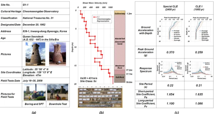
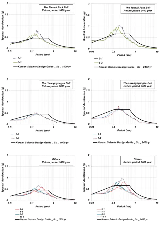
Figure 5 shows the evaluated response spectra with a 5 % damping ratio with response spectra of the Korean seis-mic design code for 22 SC sites of Gyeongju. In most cases, there are differences in the amplification coefficient and period range between the results of the site-specific re-sponse analysis and the current design code. The rere-sponse
Fig. 4. The cultural heritage information and site-specific analysis results: (a) cultural heritage information and pictures; (b) in situ test results; (c) ground response analysis results
spectra for the Bulguksa Temple area, the Mount Nam-san Belt, the Wolseong Belt, and the Tumuli Park Belt show larger resonance phenomena near site periods. In the case of the “Cheomseongdae observatory (Site No. 1–1)” in the Wolseong Belt, the evaluated response spectrum at a ∼ 0.15–0.25 s range is at most twice that of the coded response spectrum.
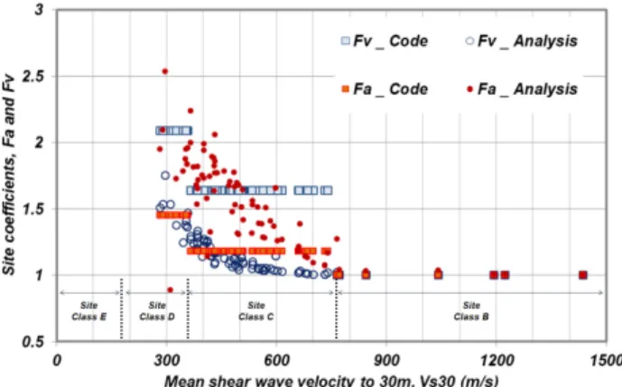
Site amplification coefficients were calculated for the thirty cultural heritage sites and the sixty sites of pre-existing data. Short-period site amplification coefficients (Fa) and long-period site amplification coefficients (Fv) were calcu-lated using the ratio of response spectra (RRS) for the soil surface to the corresponding rock outcrop in a period range of 0.1 to 0.5 s and 0.4 to 2.0 s, respectively (Kim and Yoon, 2005). Figure 6 shows the site amplification coefficients and corresponding site classification for the earthquake level of a 1000 yr return period. Fa and Fv obtained from site response analyses considering geologic conditions differ significantly from the current Korean seismic design code. The Fa val-ues were larger than those of the current Korean seismic de-sign code, whereas the Fv values were smaller than those of the code in most cases. The evaluated and coded coefficients show extremely opposing values. The distribution of coded Fv values is similar to that of the evaluated Fa values, and the distribution of coded Fa values is similar to that of the evaluated Fv values. These results also show the necessity of a site-specific response analysis.
5 GIS based seismic microzonation
The seismic geotechnical information determined by a site response analysis was interpreted using a GIS tool. In or-der to assess the seismic vulnerability, the spatial data were collected to synthetically assess the earthquake hazard in Gyeongju historic areas. GIS based microzonation for seis-mic risk is becoming more common and more essential (Cid et al., 2001; Kim et al., 2002; Sun et al., 2005; Tyagunov et al., 2006; Glatron and Beck, 2008; Salamon et al., 2010). Seismic microzonation, which is a city scale hazards distri-bution mapping based on a geotechnical information system, made a reliable estimation of spatial geotechnical data for the Gyeongju historic areas. This system incorporates a geosta-tistical kriging interpolation technique, which can be adopted for reliable prediction of geotechnical data values. Kriging is considered to be the best linear unbiased estimate and op-timal interpolation method for geological and geotechnical predictions in space, because it is a linear combination of weighted sample values that have minimum variance (Oliver and Webster, 1990).
The study area of interest for the GIS based seismic mi-crozonation is a 7 km by 7 km area encompassing the city of Gyeongju. Sixty pre-existing site investigation datasets and twenty-one in situ test datasets for cultural heritage sites (in-cluding Fig. 2) were collected from the microzonation area.
A two-dimensional numerical topographical map, three-dimensional digital elevation map, and standard geographical
Fig. 5a. Comparison of response spectra between site-specific ground response analysis and Korean seismic design code.
information map were used to construct the geotechnical in-formation system. First, a three-dimensional digital elevation map (3-D DEM) was constructed through the elevation infor-mation of the two-dimensional numerical topographical map and ASCII digital elevation values. The 3-D DEM was in-terpolated by the triangulated irregular network (TIN) in the MATLAB Mapping Toolbox (The MathWorks Inc., USA). Second, geostatistical kriging interpolation was performed
for the geotechnical data. Next, the kriging results, standard geographical information map, and coordinate system were combined on the 3-D DEM. Figure 7 shows the construction procedure of the GIS based seismic microzonation system.
Each geotechnical information system is shown in Figs. 8 and 9. The seismic information systems for the bedrock depth, natural site period, peak ground acceleration, and short-period site amplification coefficients are interrelated
Fig. 5b. Continued.
and can be considered as reasonable results. The southeast area of Gyeongju has relatively deep bedrock, relatively high potential of site amplification and relatively large site period value.
Through the geotechnical information system for the site period of historic areas, presented in Fig. 8b, the correlation between the site period and the natural period of the archi-tectural features can be shown and explained. Typically, the
site period of the Cheomseongdae ground in the Wolseong Belt was calculated as ∼ 0.21–0.23 s, as shown in Fig. 4. The natural period of Cheomseongdae was established as 4.52 Hz in the north–south direction and 4.59 Hz in the east–west di-rection through previous study (Shon and Kim, 2004). This illustrates that the ground near Cheomseongdae has high po-tential to suffer from site amplification nearby as well as res-onance with the Cheomseongdae structure itself.
Fig. 6. Site amplification coefficients and corresponding site classi-fication based on the Vs30 for the earthquake level of 1000 yr return period.
Fig. 7. The procedure of seismic microzonation: (a) three-dimensional digital elevation map by the triangulated irregular net-work; (b) kriging interpolation of geotechnical value; (c) standard geographical information map; (d) combination of digital maps.
The geotechnical information system for peak ground ac-celeration and site coefficients of historic areas (Fig. 8c and d) show that the areas of “Cheomseongdae observatory (Site No. 1–1)” and “Imhaejeon Hall site (Site No. 4–3)”, the plain area from “Mangdeoksa Temple site (Site No. 7–1)”, and the “three storied stone pagoda in Namsan-ri (Site No. 7–3)” have relatively high potential for site amplification. In other words, the plain area of Wolseong Belt (Figs. 1 and 9) and the southeast area of Gyeongju (Fig. 9) have strong possibil-ity for site amplification during earthquakes.
The construction of a GIS based seismic microzonation system would provide spatial and visible information for seismic risk of cultural heritages and historic sites. This sys-tem can include very important information on the overall countermeasures against earthquake disasters of historic ar-eas, such as Gyeongju. The data can be usefully employed for seismic risk assessment by sub-regional groups or by each architectural heritage.
Fig. 8. GIS based geotechnical information system for the earth-quake level of 1000 yr return period: (a) the bedrock depth; (b) nat-ural site period; (c) peak ground acceleration; (d) short-period site amplification coefficients, Fa.
Fig. 9. GIS based geotechnical information system for peak ground surface acceleration for the earthquake level of 1000 yr return period and the cultural heritage areas which have relatively high potentials for site amplification.
6 Conclusions
Gyeongju is the most important historic city in Korea, boast-ing a wealth of historic sites and a legacy of cultural heritage dating back more than a thousand years. The necessity of es-timating the seismic risk of historic areas has been widely recognized. Thirty in situ test sites around cultural heritages and sixty pre-existing site investigation datasets were se-lected and a revaluation of the historical records of seismic damage in Gyeongju was performed. Site-specific ground re-sponse analyses based on the in situ site investigation of the subsurface ground were performed. The evaluation of seis-mic risk through GIS based seis-microzonation for the historic area was then conducted.
The response spectra and site amplification coefficients were compared between site response analysis and current seismic design code, and it was thereupon found that the current hazard map for the Gyeongju area has potential for site amplification of 1.5 times on average. Furthermore, the plain area of the Wolseong Belt and the southeast area of
Gyeongju have a strong possibility for site amplification during earthquakes.
Acknowledgements. This study, which forms a part of the project, has been achieved with the support of national R&D project, which has been hosted by National Research Institute of Cultural Heritage of Cultural Heritage Administration. We express our gratitude to it. Edited by: M. E. Contadakis
Reviewed by: A. De Santis and one anonymous referee
References
Aki, K.: Local site effects on weak and strong ground motion, edited by: F. Lund, New Horizons in Strong Motion: Seismic Studies and Engineering Practice, Tectonophysics, 218, 93–111, 1993. BSSC: NEHRP Recommendation Provisions for Seismic
Regula-tions for New Buildings and Other Structures: Part 1. Provisions, 1994 Ed., Building Seismic Safety Council, Washington, D.C., 1994.
BSSC: NEHRP Recommendation Provisions for Seismic Regula-tions for New Buildings and Other Structures: Part 1. Provisions, 1997 Ed., Building Seismic Safety Council, Washington, D.C., 1997.
Chavez-Garcia, F. J.: Site effects: From observation and mod-elling to accounting for them in building codes, in: Earthquake Geotechnical Engineering, edited by: Pitilakis, K. D., Springer, 53–72, 4th International Conference on Earthquake Geotechnical Engineering (4ICEGE), Thessaloniki, Greece, 2007.
Cid, J., Susagna, T., and Goula, X.: Seismic zonation of Barcelona based on numerical simulation of site effects, Pure Appl. Geo-phys., 158, 2559–2577, 2001.
Glatron, S. and Beck, E.: Evaluation of socio-spatial vulnerability of citydwellers and analysis of risk perception: industrial and seis-mic risks in Mulhouse, Nat. Hazards Earth Syst. Sci., 8, 1029– 1040, doi:10.5194/nhess-8-1029-2008, 2008.
Kim, D. S. and Yoon, J. K.: Development of new site classification system for the regions of shallow bedrock in Korea, J. Earthquake Eng., 10, 331–358, 2005.
Kim, D. S., Chung, C. K., Sun, C. G., and Bang, E. S.: Site as-sessment and evaluation of spatial earthquake ground motion of Kyeongju, Soil Dynam. Earthquake Eng., 22, 371–387, 2002.
Kim, D. S., Park, H. J., Kim, J. T., Kim, N. R., and Bang, E. S.: Evaluation of spatial variations in soil stiffness using stress wave propagations, Proceedings of International Conference on Performance-Based Design in Earthquake Geotechnical Engi-neering (IS-Tokyo2009), 163–178, 15–18 June, Tsukuba, Japan, 2009.
Lee, S.-H., Sun, C.-G., Yoon, J.-K., and Kim, D.-S.: Development and Verification of a New Site Classification System and Site Coefficients for Regions of Shallow Bedrock in Korea, J. Earth-quake Eng., 16, 795–819, 2012.
Ministry of Construction and Transportation, Korean Seismic De-sign Standard, 493 pp., 1997 (in Korean).
National Research Institute of Cultural Heritage (NRICH): Study on the evaluation method for flood and seismic risks of architectural heritage, 316 pp., 2009 (in Korean).
Oliver, M. A. and Webster, R.: Kriging: a method of interpola-tion for geographical informainterpola-tion systems, Int. J. Geogr. Inform. Syst., 4, 313–332, 1990.
Park, H. C. and Kim, D. S.: Evaluation of the dispersive phase and group velocities using harmonic wavelet transform, NDT&E In-ternational, 34, 457–467, 2001.
Pitilakis, K.: Site effects, in: Recent Advances in Earthquake Geotechnical Engineering and Microzonation, edited by: Ansal, A., Kluwer Academic Publishers, 139–197, 2004.
Salamon, A., Katz, O., and Crouvi, O.: Zones of required investiga-tion for earthquake-related hazards in Jerusalem, Nat. Hazards, 53, 375–406, 2010.
Schnabel, P. B., Lysmer, J., and Seed, H. B.: SHAKE: a computer program for earthquake response analysis of horizontally layered sites, Report EERC 72–12, Earthquake Engineering Research Center, University of California, Berkeley, 1972.
Seed, H. B., Wong, R. T., Idriss, I. M., and Tokimatsu, K.: Mod-uli and Damping Factors for Dynamic Analyses of Cohesionless Soils, J. Geotech. Eng., 112, 1016–1032, 1986.
Shon, H. and Kim, S. B.: Studies on the characteristics of stone structures by shape reversal, geotechnical and dynamic structural engineerings, Proceedings of conference on Korean Society of Earth and Exploration Geophysicists, 25–48, 2004 (in Korean). Sun, C. G., Kim, D. S., and Chung, C. K.: Geologic site conditions
and site coefficients for estimating earthquake ground motions in the inland areas of Korea, Eng. Geol., 81, 446–469, 2005. Tyagunov, S., Gr¨unthal, G., Wahlstr¨om, R., Stempniewski, L., and
Zschau, J.: Seismic risk mapping for Germany, Nat. Hazards Earth Syst. Sci., 6, 573–586, doi:10.5194/nhess-6-573-2006, 2006.