A STUDY ON SPATIAL FEATURE EXTRACTION IN THE CLASSIFICATION OF HIGH RESOLUTIION SATELLITE
IMAGERY
Youkyung Han, Hyejin Kim, Jaewan Choi, Yongil Kim
Department of Civil and Environmental Engineering, Seoul National University [email protected], [email protected], [email protected], [email protected]
ABSTRACT: It is well known that combining spatial and spectral information can improve land use classification from satellite imagery. High spatial resolution classification has a limitation when only using the spectral information due to the complex spatial arrangement of features and spectral heterogeneity within each class. Therefore, extracting the spatial information is one of the most important steps in high resolution satellite image classification.
In this paper, we propose a new spatial feature extraction method. The extracted features are integrated with spectral bands to improve overall classification accuracy. The classification is achieved by applying a Support Vector Machines classifier. In order to evaluate the proposed feature extraction method, we applied our approach to KOMPSAT-2 data and compared the result with the other methods.
KEY WORDS: High Resolution Image Classification, Spatial Features, SSI, SVM
1. INTRODUCTION
With the recent commercial availability of high resolution multispectral remote sensing imagery from satellites, it has become possible to identify small scale features such as individual roads and buildings in urban environments (Shackelford and Davis, 2003). Such small scale features could not be recognized using low resolution images due to poor spatial feature detection opportunities. Therefore, methods for the classification of roads, buildings and other land cover types in urban environments, employing high resolution satellite images, are of great interest. However, due to the complex spatial arrangement of features and spectral heterogeneity within each class, conventional spectral classification methods are inadequate for this purpose (Myint et al., 2004). In order to overcome this drawback, there are many methods of combining spatial feature information with spectral information (Pakorn, 2005). Spatial analytical approaches can be categorized into spatial features extracted by moving windows or elements and a spatial classifier based on contextual decision criteria with consideration of neighboring pixels inside the classifier (Dell'Acoya et al., 2004). This paper focuses on extracting spatial features based on a region-growing algorithm to enhance the accuracy of classification. A Support Vector Machine (SVM) is employed as the classifier because it is an appropriate method of high resolution multispectral image classification. Pixel Shape Index (PSI), which is a generally used method of extracting spatial features, is used for comparison.
2. RELATED WORK
Several effective spatial feature extraction methods have been proposed. Wavelet Transform (WT) methods are used to extract texture features (Myint et al., 2004).
WT allows the extraction of different texture features at different scales, thus providing a useful alternative approach to spatial feature analysis in high resolution images. The Gray Level Co-occurrence Matrix (GLCM) method can introduce spatial information into a spectral classification, in which an image gray value is transformed into a co-occurrence matrix space and various output images are calculated, adopting different spatial measures (Zhang, 1999). Shackelford and Davis (2003) proposed the Length-Width Extraction Algorithm (LWEA), to extract the length and width of spectrally similar connected groups of pixels. Pixel Shape Index (PSI) adds an extension to LWEA (Zhang et al., 2006).
PSI extracts features in a pixel-by-pixel manner, whereby each pixel is allocated a feature value based on the spectral similarity of its neighboring pixels. PSI sums the grey similarity distance of all the radiating lines to describe the structure around each central pixel.
3. SEGMENT SIZE INDEX
PSI encounters a limitation in certain situations. Pixels in the same feature can be allocated different values according to the feature’s shape. Figure 1 illustrates this problem. Pixels A and B are belong to same feature (“doughnut” shape at left, “L” shape at right), but are nevertheless allocated different values.
Figure 1. Drawback of PSI
To overcome this issue with PSI’s radial approach, we suggest an area based feature extraction algorithm, Segment Size Index (SSI). To extract features using the SSI algorithm, first we carry out region-growing based image segmentation using principal component analysis (PC1). Region-growing approaches exploit the important fact that pixels which are close together have similar gray values, starting with a single pixel and adding new pixels gradually. After segmentation, each segment is allocated the number of pixels in the segment. For example, the pixels within a large sized segment are allocated a large value. Compared to PSI, SSI is a simple and fast method of extracting spatial features. The SSI algorithm is summarized by the pseudocode shown in Figure 2.
for each pixel i k = 1
if pixel i is not allocated SSI value repeat
Check the neighboring pixels and add them to
"segment i" if they are similar to i k = k + 1
until no more pixels can be added SSI(segment i) = k
end if end for
Figure 2. Pseudocode for SSI
4. EXPERIMENTS
This paper examines the feasibility of classification using SSI integrated with spectral information based on a SVM classifier. SVM is a good candidate for remote sensing image classification because it works well with a small training data set and is robust to the overfitting problem because it relies on margin maximization rather than finding a decision boundary directly from the training samples. In our experiments, we extracted the PC1 band from principal component analysis, then extracted the SSI features from the PC1 band and combined this with four multi-spectral bands. All five bands were then classified with SVM. The flowchart for this process is shown in Figure 3.
Figure 3. Flowchart of proposed approach
5. RESULTS AND DISCUSSION
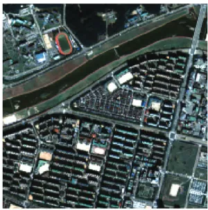
To illustrate the effectivness of SSI, we applied our algorithm to a Kompsat-2 image of Daejeon, Korea (Figure 4). The training and test datasets were mutually exclusive (Table 1). The classification result using MLC (Figure 5(a)) and SVM (Figure 5(b), (c) and (d)) with different feature indexes are shown. Table 2 shows the classification accuracies achieved.
Figure 4. Original image
Table 1. Number of Training and Test Pixels
Training (pixel) Test (pixel)
Tree 271 1,152 Grass 336 1,051 Water 308 1,107 Shadow 260 1,270
Road 258 1,131 Building 180 1,214 Bare Soil 198 1,153
Figures 5(a) and (b) are classified using just four spectral bands, and show that a SVM classifier provides a better classification result than MLC. Figures 5(c) and (d) show the results obtained using spectral bands with PSI and SSI spatial feature extraction respectively. Our proposed SSI algorithm appears to provide the highest classification accuracy. Using SSI significantly enhanced classification accuracies for the shadow and building classes, with an increase in class accuracy of at least 15%
for the shadow class. It can also be seen that the shadow class is completely distinguished from the water class by SSI.
Figure 5. Classification results
Table 2. Classification accuracies
Class MLC
(%)
SVM (%)
SVM with PSI (%)
SVM with SSI (%)
Tree 96.18 97.40 99.22 99.13 Grass 99.62 99.81 99.43 98.76 Water 98.46 99.91 99.19 95.03 Shadow 87.95 78.98 83.78 99.76
Road 76.30 92.66 89.30 88.42 Building 91.43 80.81 83.53 88.96
Bare Soil 54.03 81.70 86.73 82.31
Overall
Accuracy 86.14 89.76 91.29 93.19
5. CONCLUSION AND FUTURE WORK We suggested a spatial feature extraction algorithm to be combined with spectral features in order to raise classification accuracy for high resolution satellite imagery. The SVM classifier we employed showed better results than MLC. An area-based spatial feature index, SSI, was proposed in this paper. SSI uses a simple method to effectively describe the contextual information.
We demonstrated that our proposed SSI algorithm leads to a notable increase in classification accuracy over the PSI algorithm. Moreover, SSI is computationally faster than other methods. In order to verify the applicability of our approach, it will be necessary to carry out further tests using a wider range of data. We expect that using more diverse feature indexes together will be able to improve the classification accuracy. This will be investigated in our future work.
Acknowledgements
The authors wish to acknowledge the financial support by Korea Aerospace Research Institute and Engineering Research Institute.
References
A. K. Shackelford and C. H. Davis, 2003. A hierarchical fuzzy classification approach for high-resolution multispectral data over urban areas. IEEE Transaction Geoscience and Remote Sensing, Vol. 41, No. 9, pp.
1920-1932.
W. Pakorn, 2005. Classification of remote sensing images using support vector machines. B.E.King Mongkut's Institute of Technology Ladkrabang , Thailand.
S. W. Myint, N. S. Lam, and J. M. Tylor, 2004. Wavelets for urban spatial feature discrimination: Comparison with fractal, spatial autocorrelation, and spatial co- occurrence approaches. Photogrammetric Engineering Remote Sensing, Vol. 70, No. 7, pp. 803-812.
Y. Zhang, 1999. Optimisation of building detection in satellite images by combining multispectral classification and texture filtering, ISPRS Journal of Photogrammetric and Remote Sensing, Vol. 54, No. 1, pp. 50-60.
F. Dell'Acqua, P. Gamba, A. Ferari, J. A. Palmason, J. A.
Benediktsson, and K. Arnason, 2004. Exploiting spectral and spatial information in hyperspectral urban data with high resolution, IEEE Geoscience and Remote Sensing Letters. Vol. 1, No. 4, pp. 322-326.
L. Zhang, X. Huang, B. Huang, and P. Li, 2006. A Pixel shape index coupled with spectral information for
classification of high spatial resolution remotely sensed imagery. IEEE Transaction on Geoscience and Remote Sensing, Vol. 44, No. 10, pp. 2950-2961.