Designation of a Road in Urban Area Using Hough Transform
Joon-Cheol Kim*, Sung-Mo Park**, Joonwhoan Lee** and Soo Jeong***
664-14 1ga Duckjin-Dong Duckjin-Gu Jeonju Chonbuk 561-756 South Korea Tel) +063-270-2406, Email) [email protected]
Abstract
Automatic change detection based on the vector-to-raster comparison is hard especially in high-resolution image.
This paper proposes a method to designate roads in high-resolution image in sequential manner using the information from vector map in which Hough transform is used for reliability. By its linearity, the road of urban areas in a vector map can be easily parameterized. Following some pre-processing to remove undesirable objects, we obtain the edge map of raster image. Then the edge map is transformed to a parameter space to find the selected road from vector map.
The comparison is done in the parameter space to find the best matching. The set of parameters of a road from vector map is treated as the constraints to do matching. After designating the road, we may overlay it on the raster image for precise monitoring. The results can be used for detection of changes in road object in a semi-automatic fashion.
Key Words:
semi-automatic change detection, IKNOS, road designation in urban area, successive search, Hough transform
I. Introduction
Change detection is one of important area in remote sensing. There can be three types of change detection according to the information involved in comparison such as vector-to-vector, vector-to-raster, and raster-to-raster. The finer the resolution of a satellite image is, the more information we can obtain from the image. But the image analysis necessary for the automation in remote sensing is more difficult due to the undesirable artifacts in the image such as shadows or cars on road. Those artifacts in the image of urban area prevent the automatic change detection based on raster- to-raster comparison, because the shadow changes from time to time according to the illumination. [1][2]
In vector-to-raster method, a digital map can be rasterized into graphic form and compare it with raster image for change detection. But the comparison is not obvious because of the geometric difference between
digital map and raster image in spite of geometric correction. The other way we can consider is to convert raster image into digital map. But the automatic conversion is very hard because raster image is hard to analyze. For example, the segmentation and classification of urban image from IKONS seems to be unsolvable problem. [3][4]
In the paper we propose a semi-automatic method in which each road in vector map is treated as a key to search in the image with high resolution and the result of match designates it in the raster image. In the comparison to match, the proposed method uses Hough transform to increase the reliability. It is simple to parameterize a road in vector map due to the linearity.
On the other hand, the edge map from raster image is very complex to analyze. In the method, we devise some preprocessing methods to reduce the number of unnecessary edges and spurious candidates of lines in raster image. Our preprocessing includes coarse
classification of road, construction of edge map by Navatia operator[5], and size filtering. Also, a modified Hough transform is used to obtain more reliable designation of a road.
In the experiment we use raster image with resolution of a pixel/1mx1m from IKONOS. The proposed method works well to find the road in complex urban area.
The paper is organized as follows. In the following section, the proposed scheme is precisely described and the experimental results are shown in Section 3 with some discussion. In the final section, the contribution of the paper is summarized.
2. Road Designation in Urban Area
Essentially change detection can be achieved by the comparison of two sources of information captured different times at the same area. According to the information sources to be compared it can be categorized into 3 groups including raster-to-raster, vector-to-raster, and vector-to-vector.
In raster-to-raster methods, two raster images captured different times at the same area are compared to find changes, in which subtraction technique of image processing is widely used. The key problem for successful comparison is how to obtain the uniformity of illumination and geometry. If the illumination and geometry for the raster data are different, they should be corrected to achieve the uniformity before comparison.
In vector-to-raster methods, the vector data from digital map is compared to the information from raster image.
The information involved in the comparison, one type of information should be changed into the other to get the type uniformity of information. For example, one can change objects in the digital map into graphic data and overlay it on the raster image to find changes. But the direct comparison is usually impossible because of geometric differences. Finally the vector-to-vector
method assumes the two digital maps obtained at different time in the comparison.
In the automation sense, the raster-to-raster method seems to be the most realizable because the illumination and geometric correction is relatively easy especially in low-resolution data. In the complex urban data with high-resolution, however, it is not obvious because there are so many fine details and obstacles to be overcome.
Also, the automation of vector-to-raster technique is a hard problem in the high-resolution data as the same reasons as in the raster-to-raster one. To make better worse, the segmentation and labeling of high-resolution data to achieve the uniformity of information is tough and unsolved problem.
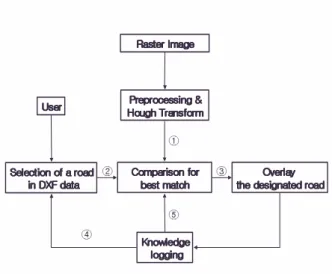
2.1 Overall Scheme
This paper concerns with the vector-to-raster technique. However, as the reason mentioned above, we consider semiautomatic method to find the changes of roads in urban area using high-resolution data. Fig. 1 shows the overall scheme of the proposed sequential change detection method. The following summarizes our proposed scheme.
Procedure of Road Designation
Step 1: Preprocess raster image and take Hough transform
Step 2: Do the followings until no more roads is specified by user
2-1: Select the road to be designated in digital map 2-2: Parameterize the selected road
2-3: Designate the road by finding the best match in accumulator
2-4: Overlay the designated road on the raster image 2-5: Storing information about the designated road Step 3: Find the new road in accumulator using the
information captured in Step 2-5
There may be three possible cases to be considered for detecting changes of roads. The first case is “existing road” in which a road exists in both digital map and raster image. The second case is “removed road” in which a road exists in digital map but does not in raster image. The third case is “new road” in which a road does not exist in digital map but does in raster image.
jGG jGG jGG jGG
G
GG
G
r
r
r
r
zGGG
zGGGzGGG
zGGG
GkmG
GkmGGkmG
GkmG v Gv Gv Gv G
GG
GGGG
GG
|
|
|
|
yGp
yGp
yGp
yGp
wGMG wGMG wGMG wGMG oG{
oG{
oG{
oG{
ྙ
ྚ ྛ
ྜ
ྜྷ
Fig. 1 Overall scheme of successive change detection
In the first and second case, each road in a digital map can be specified by user. In the first case, our scheme finds the best match and designate the road in Step 2-4. But our scheme may provide wrong match, and displayed road cannot be well coincide with the raster image in the second case. In the step 2-4, the user can identify what happens during the matching process and verify the results with the help of our scheme. The roads in urban area have some predefined widths according to the number of pathways. This information about the width in the image is stored in Step 2-5 and it is used in Step 3 to find new roads in raster image.
2.2 Preprocessing and Hough transform
Our scheme assumes the roads in urban area are linear. If a road violates the assumption, it may be decomposed into linear segments. By the assumption, a
road in digital map can be easily parameterized by its direction and distance from the specified origin.
Preprocessing of raster image consists of the steps as shown in Fig. 2 in order to reduce the unnecessary edge points for designating roads.
yGp
x¡GMGjGzGGy
lGmG GuGv
z¡GmGGyGzGnGGl
oG{
h
Fig. 2 Preprocessing and Hough transform
2.2.1 Quantization
The edge map directly taken from the image is too complex to designate a road. In quantization step, we approximately separate road from non-road objects to reduce the spurious edges depending on the reflectance characteristics. General knowledge for the separation we use is in Table 1. The number in the table denotes the level of luminance in the image. In this quantization, roads with level of luminance corresponds level 2 or 3 are approximately identified.
Table 1. Knowledge for quantization
v
sGG
jGGGG
W
jGGG
^
jGGGGSGi GG
G
]
jGGGGTG
\
jGGGGG
[
i GGGSGi GGG
Z
i GGGSGjGGGG
Y
uTjGGGG
X
2.2.2 Construction of edge map
Prior to take Hough transform, the edge map of a quantized image is constructed. As mentioned before, quantization step reduces many unnecessary edges due to the crude separation of roads. In this step, Navatia convolution operators are used to find edges. Those operators provide both the magnitude and finer directions of edges than Sobel ones. [6]
In spite of quantization to remove unnecessary edges, still so many isolated edge points are remained in the edge map. Since the road boundary must have consecutive edges, those isolated edges or small group of consecutive edges are removed by size filter. The edge groups in which the number of consecutive number of 15 edge pixels are removed in the experiment, which corresponds 15m in resolution of 1 pixel/1mx1m.
2.2.3 Hough Transform
The reason we use Hough transform in the paper is that Hough transform is a robust estimator to find a line.
In the transform an edge point in edge map is converted to a line in parameter space. An edge point at (x,y) can be represented by a line equation [7][8]
θ θ
ρ = x cos + y sin
, (1)where
2 2 2 1 2
2 2
1
N N N
N + ≤ ≤ +
− ρ and
2 2
θ π π
< ≤− .
For computer implementation, the parameter space is quantized as two-dimensional array called accumulator. Whenever every edge point is converted into a line of parameter space, the value of every bin in accumulator corresponding to the line is increased by 1.
After considering all the edges, one can do the majority vote to find a line in accumulator.
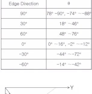
Actually we modified the conventional Hough transform to adapt our purpose. Since the coarse
direction of an edge is already known from Navatia operator, the possible direction of a line is approximately constrained. Ideally the direction of line is the same as that of edges as shown in Fig. 3. Using this fact, we only accumulated bin values in eq. (1) among which θ satisfies Table 2 according to the edge direction. By this way, we can greatly reduce the candidate lines in parameter space.
Table 2. Constraints of θ from edge direction
[_° ^]°
]W°
TX[° T[Y°
T]W°
T[[° T^Y°
TZW°
W° X]°SGTY° TXY°
W°
X_° []°
ZW°
^_° T`W°SGT^[° T__°
`W°
lGk θ
θ ρ
kGGl
Fig. 3. Ideal relation between edge and line directions
2.3 Comparison to match
A road specified in the digital map is parameterized by (ρ1, ρ2, θ), in which the width of the road corresponds to ρ2-ρ1. It provides a key to compare in the accumulator constructed from Hough transform. If the geometry of a digital map coincides well with the corresponding raster image, the search is obvious.
Unfortunately, however, they are different due to some errors in correction process. Therefore the key parameter can be used as only a constraint to search for designation.
We assume the geometric difference does not exceed some thresholds on ρ and θ. These values around the key parameter provide the region of search to find the specified road.
For successive designation of each road in vector map, the corresponding values of counts to the parameters for previous matches in accumulator are cleared. This makes better search in the successive designation because less effort is needed in the process by decreasing the number of alternatives.
In the process, the “existing road” can be easily designated but the “removed road” may provide poor or no matching with in the region. We used the region with -24< ρ < 24 and -15 °< θ < 15°.
III. Experiment and Discussion
G
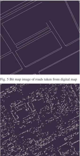
Fig. 4 shows the raster image of urban area used in the experiment. The image is taken from IKONOS with resolution of 1 pixel/1mx1m and the size of 512x512 pixels. Fig 5. represents corresponding bit map image of roads taken from digital map. After preprocessing, we could obtain an edge map as shown in Fig. 6. Note that there are still so many spurious and missing edge points to designate roads. After specifying several road objects in Fig. 5, we could obtain the roads as shown in Fig. 7.
The lines in Fig. 7 are obtained from matching process in accumulator after Hough transform. Note that the lines of road boundaries are not bounded, because we do not know the start and end points of a road boundary.
Even though it is completely fit the real road boundary, the lines informs the user the guide line for monitoring the “existing roads”.
We do not show the experimental results of
“removed road” and “new road”, because we do not have such data. Even though it is not includes them in the
paper, we did the experiment with an artificial data set and obtain a promising result.
IV. Conclusion
This paper deals with a type of change detection based on vector-to-raster comparison. The comparison of an object in digital map with that of raster image is not obvious due to the geometric difference. Also, the automatic segmentation and classification of raster images with high resolution is a very hard problem because there are too many fine details and shadows.
In the paper, we propose a method to designate a road in raster image specified from digital map. A boundary of roads is assumed to be linear and a Hough transform is used to make robust estimation. To make more reliable results, we devised several preprocessing methods and a modified Hough transform.
Based on the designation method, we also propose a change detection scheme of road objects in urban area.
In the scheme, user can sequentially specify a road from digital map and verify it from the result of designation.
During the process, user can easily detect the changes in road objects. We believe the scheme that uses Hough transform can also be applicable to designate the building objects
Fig. 4 Raster Image of Urban area
Fig. 5 Bit map image of roads taken from digital map
Fig. 6 Edge map of Fig. 5
Fig. 7 Overlay the designated roads
ACKNOWLEDGEMENT
This work is supported by the Electronics and Telecommunications Research Institute(ETRI)
REFERNCE
[1] P. M. Mather, Computer Processing of Remotely- Sensed Images, John Wiley $ Sons, 1987
[2] J. A. Richards, Remote Sensing Digital Image Analysis, SpringVerlag, 1994
[3] N. S. Netanyahu, et al. "Robust detection of straight and circuir road segments in noisy aerial images,"
Pattern Recognition, Vol.30, No. 10, pp1673-1686, 1997 [4] M. A. Fischer, et al, "Detection of roads and linear structures in low resolution aerial imagery using a multisource knowledge integration technique,"
Computer graphics and Image Processing, Vol 15, pp 201-223, 1981
[5] R. Nevatia and K. R. Babu, "Linear Feature Extraction and Description", Computer Graphics and Image Processing, 13, pp257-269, 1980
[6] R. M. Haralick and L. G. Shapiro, Computer and Robot Vision, Volume 1, Addison Wisley, 1992
[7] D. H. Ballard and C. M. Brown, Computer Vision, prentice Hall, 1982
[8] M. Sonka et al, Image Processing, Analysis, and Machine Vision, PSW, 1999
* Dept. of ECE in Seonam University, Korea
** Dept. of EIE in Chonbuk National University, Korea
*** ETRI, Korea
E-mail: [email protected]