CREATION OF DIGITAL CITY MODEL FROM A SINGLE KOMPSAT-2 IMAGE
Hye Jin Kim, Jae Wan Choi, You Kyung Han, Yong Il Kim
Department of Civil and Environmental Engineering, Seoul National University [email protected], [email protected], [email protected], [email protected]
ABSTRACT ...
A digital city model represents a 3D environment of a city with various city object information such as 3D building model, road, and land cover. Usually, at least two satellite images with some image overlap are necessary and a complex satellite-related computation needs to be carried out to create a city model. This is an expensive technique, because it requires many resources and excessive computational cost.
The authors propose a methodology to create a digital city model including 3D building model and land cover information from a single high resolution satellite image. The approach consists of image pan-sharpening, shadow recovery, building occlusion restoration, building model extraction, and land cover classification. We create a digital city model using a single KOMPSAT-2 image and review the result.
KEY WORDS: Digital City Model, KOMPSAT-2, Building Extraction, Occlusion Restoration, Shadow Recovery, Classification
1.
INTRODUCTION
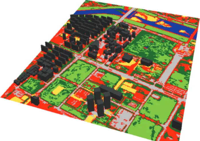
During the past few years, improvement in resolution has broadened the number of applications for satellite images to include areas such as GIS database construction and updating. Creation of a Digital City Model (DCM) from high resolution satellite imagery is an active research topic. DCM is an accurate representation of a city in a 3-D environment, including 3D building models.
It is used in a variety of applications such as simulation and training systems, visualization, telecommunication planning, maintenance and analysis. Chan (2005) generated a DCM of Beijing city through combination of various data such as QuickBird images, aerial photos, and thematic maps. Poli (2006) generated a 3D city model using Cyber City-Modeller (CCM) and stereo aerial photos and stereo QuickBird images. Typically, at least two satellite images with some image overlap are necessary and combinations of satellite-related computations need to be carried out to arrive at a satisfactory result. This is an expensive technique, mainly because it requires significant resources. Paul (2006) proposed a DCM creation methodology using a single off-nadir high QuickBird image.
We aim to create a DCM including 3D building model and land cover information from a single high resolution satellite image from KOMPSAT-2. The methodology consists of image quality enhancement, building and shadow extraction, and land cover classification. In order to enhance the image quality, we performed a pan- sharpening, a shadow recovery, and a building occlusion restoration. 3D building model was extracted based on the Triangular Vector Structure (TVS) hypothesis (Kim, 2006). Then, land cover classification with segmentation was applied to the non-building area of the image. A DCM can be generated by integrating the land cover map
and the 3D building model. The entire workflow is illustrated in Figure. 1.
Single KOMPSAT-2 image Pan-sharpening Building/shadow extraction
Shadow area recovery Building occlusion restoration
Land cover classification
Digital City Model (DCM) Figure 1. Flowchart
2.
BUILDING AND SHADOW EXTRACTION
To enhance the image interpretation, a high resolution
multispectral image is created from a panchromatic image
and multispectral image. In our approach, we used the
pan-sharpening module of the PCI Geomatica. The 3D
building model and shadow region are extracted semi-
automatically using TVS hypothesis. Its basic concept
comes from this fact: the triangle consisting of each
building’s bottom point, its corresponding roof point and
the shadow end point are always similar to one another in
a single satellite image, because the altitude of the
satellite and the sun are high enough to assume their
projection angles are in parallel. Through this, we can extract the building model information including height and 2D footprint, and shadow region. In this approach, we extracted the buildings that were larger than 100 square meters.
Figure 2. Conceptual diagram of building extraction
3.SHADOW AND BUIDING OCCLUSION
RESTORATION
The building shadow in the high resolution satellite imagery interrupts image analyses such as feature extraction and classification. We performed shadow recovery by linear stretching and edge smoothing. The non-shadow area used as reference for recovery was obtained using morphological filtering of the shadow region. Then, shadow pixels were stretched linearly, based on the mean value of the surrounding non-shadow area; the shadow edges not bordering the building were smoothed.
In order to restore the occlusion caused by lying building on the image, we applied the inpainting method to the occlusion area. Image inpainting is the algorithm to remove certain parts of an image, scratches on a photo or unwanted occluding objects (Bertalmio, 2000). Among the various inpainting methods, inpainting based on the Fast Marching Method (FMM) was used in our approach (Telea, 2004). The FMM inpainting is appropriate for large images because the calculation is simple and fast.
Shadow recovery
Occlusion restoration
Figure 3. Shadow recovery and occlusion restoration .
4.