1. Introduction
In the stage of the civil uses of commercialized high- resolution satellite imagery such as ORBVIEW, IKONOS or up-coming KOMPSAT-2, applications of remote sensing has been widely extended to new fields or problem-solving beyond traditional application
domain (Khuen, 1997).
The imagery provides detailed and precise spatial information that is not contained by the medium and course resolution satellite imagery. The major benefit is in that it can be applicable to urban application and its related fields. It is issued that it needs some new approach.
Automatic Road Extraction by Gradient Direction Profile Algorithm (GDPA) using High-Resolution Satellite
Imagery: Experiment Study
Ki-Won Lee*, Young-Chul Yu**, and Bong-Gyu Lee*
Information Engineering Div., Hansung University*
Department of Geosciences, Chungnam National University**
Abstract :In times of the civil uses of commercialized high-resolution satellite imagery, applications of remote sensing have been widely extended to the new fields or the problem solving beyond traditional application domains. Transportation application of this sensor data, related to the automatic or semi- automatic road extraction, is regarded as one of the important issues in uses of remote sensing imagery.
Related to these trends, this study focuses on automatic road extraction using Gradient Direction Profile Algorithm (GDPA) scheme, with IKONOS panchromatic imagery having 1 meter resolution. For this, the GDPA scheme and its main modules were reviewed with processing steps and implemented as a prototype software. Using the extracted bi-level image and ground truth coming from actual GIS layer, overall accuracy evaluation and ranking error-assessment were performed. As the processed results, road information can be automatically extracted; by the way, it is pointed out that some user-defined variables should be carefully determined in using high-resolution satellite imagery in the dense or low contrast areas. While, the GDPA method needs additional processing, because direct results using this method do not produce high overall accuracy or ranking value. The main advantage of the GDPA scheme on road features extraction can be noted as its performance and further applicability. This experiment study can be extended into practical application fields related to remote sensing.
Key Words :Accuracy, GDPA Scheme, High-resolution Satellite imagery, Ranking, Road Extraction.
Received 27 February 2003; Accepted 20 August 2003.
The main issues of NCRST (National Consortia for Remote Sensing in Transportation) organized by US DOT/NASA are in transportation application of satellite imagery acquired from multi-sensors, technology development, or case studies of various fields such as infrastructure, hazard, environment assessment, and traffic flow (U.S DOT/NASA, 2002). According to this trend of high-resolution imagery and NCRST activities, transportation application is thought to be as one of the important fields in uses of remote sensing imagery. The automatic or semi-automatic road extraction tasks from high-resolution remotely sensed imagery is also one of the on-demand research topics in this domain.
For this task, road characteristics should be taken into account, and Park and Saleh (2001) already discussed as follows.
In the radiometric one, road feature consists in various grayscale along road extent, and relatively constant grayscale and texture between boundaries, and, in the spectral one and geometric one, generally show consistent signature and long and continuous characteristics, respectively. But problems in extracting roads from imagery also could be explained with the following aspects; first, line disconnection due to covering over roads and detection of wrong objects or areas due to similar grayscale in the radiometric, second, differential spectral information due to camera angle, atmospheric distortion and inconsistent spectral response in the spectral, and third, differential horizontal profiles due to various widths and types of roads.
It is known that there are diverse approaches of road extraction methodologies and schemes. Park and Saleh (2001) summarized them using radiometric and geometric information. In the radiometric view, several schemes can be applied: edge detection filters, image segmentation, and signal processing. Whereas, geometry-based schemes can be explained as several levels and method such as directional filtering, edge- detection filtering, optimal search algorithm, Hough
transformation, and model-based template method.
However, extraction of road features in reality is somewhat complicated one, so that this task needs several procedures, including optional processing: image registration and geo-referencing, radiometric/geometric rectification, noise elimination, data conversion, and output generation, and so forth.
This study focuses on automatic road extraction using high-resolution remotely sensed imagery for the aspect of conversion of data into information and for the further transportation geographic analysis; especially, Gradient Direction Profile Algorithm (GDPA) scheme is applied for this purpose.
Wang and Zhang (2000) studied several aspects on applicability of GDPA to automatic road extraction using medium or coarse resolution satellite imagery such as SPOT, LANDSAT TM, and aerial photograph with 5 meters resolution; in their study, results of road extraction using SPOT PAN (10m) showed high accuracy in the rural-agricultural area and the forested area, and those of air photo image was good at the urban-residential area.
Saleh (2001) classified this new method into road detection scheme based on radiometric information.
This approach aims at the prototyped software development of GPDA and testing of practical applicability with high-resolution satellite imagery of IKONOS of 1 meter resolution, by changing or controlling some parameters in this program. Therefore, firstly, GDPA and its main modules were briefly reviewed, and the implementation under Microsoft visual integrated programming environment was presented with the main user interface, input imagery processing, and internal processing steps. The extracted results were converted into binary image, and then studied through error-assessment method with actual digital map data of NGI (National Geographic Institute) at the same covering region.
2. GDPA for Road Network Extraction
The main concept of this method is to fit a profile crossing a line using a polynomial function and find the point where the function reaches its extreme value. If the line is light-toned, which is the case of road features, the maximum extreme value is found within the profile.
Sometimes, the GDPA method is classified as profile analysis one of methods for automated linear feature tracking, unlike Hough transform method and optimal search method (Gruen and Li, 1997; Karathanassi, et al., 1999).
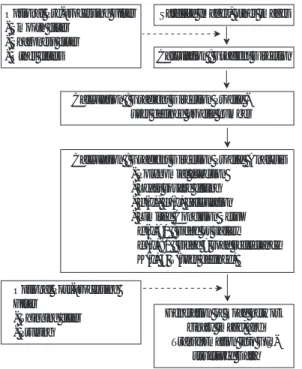
The algorithm of GDPA, which was proposed by Wang et al.(1992) and Wang and Zhang (2000), was reviewed in Fig. 1.
① Computation of edge enhancement by image filtering
② Calculation of the maximum ‘Gradient Direction’
for each pixel
③ Defining ‘Gradient Direction Profile’ as a list of
pixels along the g radient direction
④ Fitting ‘Gradient Direction Profile’ using polynomial function, and determination of the parameters in the fitting function
f(x) = b0+ b1x + b2x2x ∈[k1, k2] (1)
⑤ Computation of the derivatives of fitting function, and find extreme value (x0) in the pre-defined boundary
⑥ Computation of curvature function of fitting function, and estimation of extreme value condition with respect to first derivative, second derivative, and curvature function
K(x) = ‰f 9(x)‰
/
[1 + f0(x)2]1.5 (2)⑦ Determination of thinning variable with respect to curvature function
K(x0) > A given constant T (3)
⑧ Converting to binary-type image showing road element pixel based on acceptance of extreme value satisfied conditions after steps above were applied at the original image
x0∈[k1, k2]
f9(x0) = 0 (4)
f0(x0) < 0
Fig. 2 illustrates the concept of gradient direction or direction of maximum slope: A3is gradient direction if A1is ridge for pixel location at g, shown at the step ②.
Fig. 1. GDPA scheme for road extraction.
Fig. 2. Concept of gradient direction or direction of maximum slope: A3is gradient direction if A1is ridge for pixel location at g.
Optional Pre-processing Filter - Smooth filter
- Sharpness filter - Other filters
Satellite Images, other images
Calculation : Gradient Direction
Generation of Road network binary image, and Transformation into GIS-
structured Data Optional Post-processing
Filter - Thinning filter - Pruning
Calculation : Gradient Direction Profile - user defined profile number
Calculation : Gradient Direction Profile Analysis - Polynomial function
- Least square fitting - f’(x), f”(x) calculation - Limited Condition Setup
f’(x)=0 : ridge or valley f”(x)<0 : ridge = road reflectance K(x) > T(user defined)
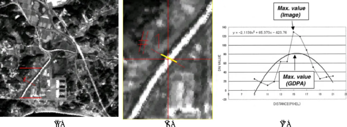
Fig. 3 represents the example for steps of ②, ③, and
④ with KOMPSAT EOC imagery at the testing region as the part of the Namyangju-city, nearby Seoul: (A) Sample image of KOMPSAT EOC, (B) Enlarged portion showing road, and (C) Result of least square fitting at (B).
The GDPA method detects lines by analyzing the profile that is perpendicular to the line and finding its single peak or valley. It allows for variation of both reflectance and gradient values along the line features.
However, when applying the GDPA method, some parameters are considered: the size of the linear features, the image resolution, and the contrast of the linear features and their immediate neighbors.
In the profile analysis, the length of the profile is determined by the user according to the characteristics of the linear features on the image. When the length of the profile is shorter than the width of the road, the road cannot be detected, because there is not an extreme value in the middle part of roads. Therefore, the length of the profile should be longer than the width of the roads in order to find the peaks. The profile should not be too long, because of not including more than one road. If more than one road is presented and included in a single profile, this method cannot detect the extreme
value. The background features next to the linear features also affects the detected results. For instance, in an urban downtown area, road density is high and the features surrounding roads may have similar reflectance characteristics. The profiles perpendicular to the roads in a downtown area do not have a mono-peak property.
Wang and Zhang (2000) suggested the most suitable conditions for extraction of the effective result using this GDPA scheme: The road width close to the image resolution as one or two pixels, the profile length of two to four pixels longer than the road width, and a mono- peak within the profile perpendicular to a road.
When compared to road detection problems using the mid or coarse imagery in spatial resolution in the urban area or the downtown area, it has been known that road extraction from high-resolution imagery is affordable.
However, the downtown areas itself are extremely complex, and sometimes shows discontinuous features, because of the interference of natural conditions, buildings and their shadows. Furthermore, roads from the mid or the coarse resolution imagery shows lines or line-type features; on the contrary, those of high- resolution imagery appears as a narrow areas or polygon-type feature.
Fig. 4 demonstrates types of road features using high-
Fig. 3. Example of gradient direction computation by polynomial least square fitting: (A) Sample image of KOMPSAT EOC, (B) Exaggerated portion showing road, and (C) Least square fitting at (B).
(A) (B) (C)
resolution satellite image (Han, 2001). Even though using same image data of Fig. 4(A), its result, as extracted roads, can be different in many ways. Fig. 4 (B), (C) and (D) are double line, single centerline, and foot-printed type, respectively. It is doubtful which type is suitable to show exact roads in these results.
3. Quantitative Error Evaluation
The results from the GDPA method needs to error evaluation process between extracted ones and the actual road location. As the first simple method for error evaluation, after conversion road layer into bitmapped image format, the GDPA results and this image are
compared using difference operation. Three values are shown as -1, 0, and +1. The value, 0 means completely matched, whereas other unit values represent the newly constructed road for digital map updating or the true error for road which were extracted by the GDPA method.
However, in this study, quantitative error assessment method to evaluate error rate by Wang and Liu (1994), pixel-counting method was applied. Let Nce and Ntr be the number of pixels, extracted as road element and the number of pixels of true road on digital map, respectively, assuming Nte as the total number of pixels in area of interests.
overall accuracy = Nce
/
Ntrcommission error = (Nte-Nce)
/
Ntr (5)Fig. 4. Types of road features using high-resolution satellite image (Han, 2001): (A) A sample image of IKONOS 1M, (B) Double centerline, (C) Single centerline, and (D) Foot-print type.
(A) (B)
(C) (D)
omission error = 1 _Nce
/
Ntrranking = 200
/
[(1 + omission)*(1 + commission)*(2 + ‰omission _commission‰)]
The overall accuracy is the fraction of pixels correctly extracted as roads. The commission error is the number of pixels incorrectly extracted as road pixels divided by the number of true road pixels, and omission error is one minus the overall accuracy.
Further, ranking combines the measures of commission and omission errors and their variation: the higher the commission or omission errors, the lower the ranking. Also, it reveals that the smaller the difference between the commission and omission errors, the higher the ranking. Therefore, it can be interpreted that the high value of the ranking represents better results.
4. Results and Discussions
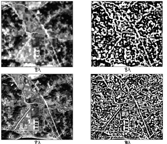
In this study, road detection by the GDPA scheme was first carried out with LANDSAT 7 ETM+ image (Fig. 5 (A)) and KOMPSAT EOC image (Fig. 5(C)). As shown at the Fig. 5(B) and (D), the GPDA processed results in the binary format image show the cases of LANDSAT 7 ETM+ and KOMPSAT EOC with the same input parameters and the same region, in a local government located nearby eastern part of Seoul, respectively.
Table 1 represents the results of error assessment using overall accuracy, commission error, omission error, and ranking, with the binary images of road features extracted from GDPA and the binary format
Fig. 5. Extraction of road features using GDPA: (A) LANDSAT 7 ETM+ image, (B) GDPA result using (A), (C) KOMPSAT EOC image at the same area in (A), and (D) GDPA result using (B).
(A) (B)
(C) (D)
image of road centerline within digital map of NGI (National Geographic Institute) at the same covering region, for Fig. 5(C) and (D), respectively. In this accuracy assessment, both images are processed as the same pixel size of 10 meters.
These result images as initial experiment were not post-processed thinning or pruning method in order to eliminate noise pixels and clusters in them. Therefore, overall accuracy is relatively low, as 20% of LANDSAT 7 ETM+ to 45% of KOMPSAT EOC image. After additional post-processing such as thinning and pruning to both results, this overall accuracy could be more increased.
Actually, in this study, the 1m IKONOS data was not acquired and processed yet, at the AOI (Area Of Interest) covering LANDSAT 7 ETM+ and KOMPSAT
EOC scenes. Therefore, Fig. 6 shows some results of experiment of the GDPA method using high-resolution satellite image in other area, according to determine user-defined parameters of N (Pixel number of profile) and T (Tolerance of curvature function). Fig. 6(B), (C), and (D) are results of N=2 and T=0.005, N=4 and T=0.005, and N=10 and T=0.005, respectively. As shown in Fig. 6, these user-defined parameters influence processed result as other pattern. Especially, visual interpretation of roads extracted from high-resolution imagery is not simple, compared to those of LANDSAT 7 ETM+ or KOMPSAT EOC images. As the visual aspects in these three results, parameters of N and T are related to road width and noise level on the extracted image, respectively.
Normally, the results of road extraction need more thinning process or manual digitization; whereas, the original image and the first processed result were presented with proper accuracy evaluation.
Table 1 (B) represents the results of accuracy assessment with Fig. 6(B) of extracted roads from the 1 m IKONOS image. In this process, both images of extracted roads and road centerline image were matched with 4 meters form digital map. Because the IKONOS image is covered in the different area from the mid or coarse resolution image, direct comparison with Table 1 (A) is meaningless. But same processed steps were carried out. The initial overall accuracy by only GDPA method without further noise elimination processing is 70%, and this value is somewhat at the satisfied level, for the case that extra processing is not performed, and original truth data is not high-scale road layer. As for ranking values on these results, they are proportionally increased along the resolution level in detail.
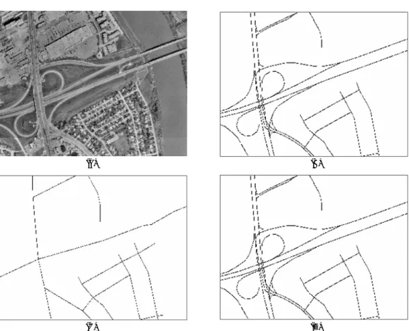
Fig. 7 represents digital road layers in GIS format on the GDPA results; Fig. 7 (A) is road centerline from digital GIS data of 1:25:000 scale and the processed results of KOMPSAT EOC and Fig. 7(B) is road boundary layer and the GDPA result from 1m IKONOS Table 1. Example of Accuracy assessment using overall
accuracy, commission error, omission error, and ranking, with binary images of road features extracted from GDPA and digital map at the same area of each image coverage: (A) LANDSAT 7 ETM+ and KOMPSAT EOC, (B) IKONOS 1 m.
(A)
Image Type LANDSAT 7 ETM+ KOMPSAT EOC Used Data Fig. 4 (B) Fig. 4 (D) and Fig. 7(A)
Re-sampled resolution 10 10
Overall Accuracy 0.200 0.446
Commission error 2.293 2.046
Omission error 0.800 0.554
Ranking 9.661 12.097
Image Type LANDSAT 7 ETM+ KOMPSAT EOC
(B)
Image Type IKONOS 1M
Used Data Fig. 6 (B) and Fig. 7 (B)
Re-sampled resolution 4
Overall Accuracy 0.700
Commission error 1.793
Omission error 0.300
Ranking 15.772
Image Type IKONOS 1m
Fig. 6. Experiment of GDPA using high-resolution satellite image: (A) A portion of IKONOS 1m image in the Guri-city, nearby Seoul. Results according to different user-input parameters of N (Pixel number of profile) and T (Tolerance of curvature function): (B) N=2 and T=0.005, (C) N=4 and T=0.005, and (D) N=10 and T=0.005.
(A) (B)
(C) (D)
Fig. 7. Digital road layer in GIS format, scaled 1:25:000, on the GDPA result: (A) KOMPSAT EOC and (B) IKONOS 1m.
(A) (B)
data. For the accuracy evaluation and ranking computation of LANDSAT 7 ETM+ and KOMPSAT EOC, road centerline is used for truth; by the way, road boundary layer is used for 1m IKONOS data. According to the visual interpretation from Fig. 7, it is possible to detect the new road features that are not shown at 1:25,000 digital road data, by comparing them to the GDPA results.
5. Conclusions
As for the GDPA scheme for automatic road extraction, Wang and Zhang (2000) previously discussed several points. First, the same line detection algorithms do not fit to all sensor data. Second, higher resolution image are necessary to dense road network in the urbanized areas, and uses of coarse resolution image data can produce the best road map. Lastly, with higher- resolution images, the extreme complexity and influence of shadows do not permit accurate road extraction, but the GDPA scheme is one of the encouraging methods for road detection in the urban residential areas, with some more post-processing schemes such as thinning or pruning.
While, Saleh (2001) commented that there are advantages in GDPA over other algorithms. First, edge detection and road tracking are done simultaneously, and second, it can be described local conditions of features. And it can be implemented as relatively simple procedure using mainly gradient values on the original image. Drawbacks of this scheme are reported that this method provides bad results in the urban area due to complex structures and various obstacles or in the situation of similar radiometric contrast between roads and backgrounds or surroundings. But these problems is not limited just for this GDPA scheme.
As for practical considerations with these points, the concluding remarks in this study are as follows:
(1) Using this algorithm of GDPA, road information can be automatically generated; however, some user- defined variables such as k1, k2or N and T should be carefully chosen in using high-resolution satellite imagery in the dense or low-contrast areas. However, as pointed out other researches, road detection using the mid or coarse spatial resolution can be drawn on the satisfactory level. Moreover, this situation is almost same cases using other road or line detection methods.
(2) In road extraction task, the GDPA method needs further processing at the pre-processing and post- processing stages so that the results from application of this method only do not produce high overall accuracy or ranking value. Judging from the results in this study, post-processing, not provided in this prototyped module yet, is more important to extract road features than pre- processing.
(3) The main advantage on road features extracted by the GDPA scheme can be noted as its performance and further applications of the results extracted. Actually, human-based image understanding and manual digitization are somewhat useful, only with the road features or network information detection. If full functions such as GIS layer conversion as well as post- processing modules are provided used to GIS database for road information. If road databases of centerline and boundary lines are already built in a local government, this method can be applied to road feature updating purpose. Further, for road extraction in the large dense area or inaccessible region, this method is for road database building in GIS-typed data structure.
(4) As for future work, analytical processing modules for transportation geography, some quantitative indices for connectivity computation of road network such as a index, b index, or g index, in Taaffe and Gauthier (1973) and some transportation planning indices in Lee (2002), can be effectively utilized with automatic road extraction.
Acknowledgements
This study is carried out a part of “Technology Development for Analysis of Urban Transportation Environment using Satellite Imagery” as one of independent research topics supported KISTEP Research Project for Remote Sensing Land Application, funded by Korean Ministry of Science and Technology.
The authors thank the anonymous reviewers for critical comments and expression correction on manuscript.
References
Han, K., 2001. Addressing Multi-centerline Representation Issues: From a Transportation Engineering Perspectives, Presentation to the NCRST, UCSB.
Gruen, A. and H. Li, 1997. Semi-automatic Linear Feature Extraction by Dynamic Programming and LSB-Snakes, PE&RS, 63: 985-995.
Karathanassi, V., C. Lossifidis and D. Rokos, 1999. A Thinning-based Method for Recognizing and Extracting Peri-Urban Road Networks from SPOT Panchromatic Images, Int. Jour. of Remote Sensing, 20: 153-168.
Khuen, B., 1997. Commercial Application for High Resolution Geo-spatial Imagery, PE&RS, 63:
933-941.
Lee, K., 2002. Prototyping of Some Indexes Extraction for Transportation Reference Planning using Remotely Sensed Imageries, Korean Jour. of Remote Sensing, 18(5): 263-271.
Park, J. S. and R. A. Saleh, 2001. Comprehensive Survey of Extraction Techniques of Linear Features from Remote Sensing Imagery for Updating Road Spatial Databases, CLEM Specialist Meeting.
Taaffe, F. J. and H. L. Gauthier, 1973. Geography of Transportation, Prentice-Hall, NJ.
U. S. DOT/NASA, 2002. Achievements of the DOT- NASA Joint Program on Remote Sensing and Spatial Information Technologies: Application to Multimodal Transportation: 1-79.
Wang, J., P. M. Treitz, and P. J. Howarth, 1992. Road Network Detection from SPOT Imagery for Updating Geographical Information Systems in the Rural-Urban Fringe, Int. Jour. of Geographical Information Systems, 6(2): 141-157.
Wang, J. and W. Liu, 1994. Road Detection from Multi- Spectral Satellite Imagery, Canadian Jour. of Remote Sensing, 20: 180-191.
Wang, J. and Q. Zhang, 2000. Applicability of a Gradient Profile Algorithm for Road Network Extraction-Sensor, Resolution and Background Considerations, Canadian Jour. of Remote Sensing, 26: 428-439.