IMPROVING EMISSIVITY ESTIMATION IN RETRIEVING LAND SURFACE TEMPERATURE WITH MODIS DATA
Tang-Huang Lin¹,Gin-Rong Liu, Fuan Tsai and Ming-Chang Hsu
Center for Space and Remote Sensing Research, National Central University, Jhongli, Taiwan 320 1. Corresponding Author, Assistant professor, Tel:(886)-3-4227151~57633, E-mail:
[email protected]
ABSTRACT Many researches conducted to investigate the relationship between surface emissivity and surface temperature in the past two decades and pointed out that the emissivity play a key role in applying remote sensing data to retrieve surface temperature. The task of surface temperature estimation is so important in many research fields, such as earth energy budgets, evapotranspiration, drought, global change and heat island effect. Therefore, it is indispensable to develop an effective and accurate technique to estimate the emissivity for accurate surface temperature estimations. This study developed an improved emissivity estimation technique for the use of surface temperature retrievals with MODIS data. The result of applying this improved technique using Band 31 of MODIS shows that the accuracy of estimated surface temperatures will be improved. This study also uses MODIS data observed in 2005 to establish the relationship between the surface emissivity correction factor and NDVI. Through the use of these correction factors, the land surface temperature can be retrieved more accurate with MODIS data.
KEY WORDS: Emissivity, Land Surface Temperature, MODIS Data
1. INTRODUCTION
As we known, the surface temperature is a significant factor of the issues in earth energy budgets, evapotranspiration, drought, global change and heat island. In order to understand the earth system better on the global scale, there are many approaches have been developed for the retrieve sea-surface temperature (SST) and land-surface temperature (LST) from satellite data in the past decades (Bhattacharya and Dadhwal, 2003; Wan et al., 1997; Li and Becker, 1993). Such as the split- window algorithms have been developed to retrieve sea and land surface temperature from NOAA AVHRR data (Becker and Li, 1990). Since the surface emissivities are the key factor for the land surface temperature retrieving, the relationship between land surface emissivities and NDVI values are constructed with AVHRR data for LST retrieved (Griend and Owe, 1993; Valor and Casselles, 1995).
On the other hand, the MODIS (Moderate Resolution Imaging Spectroradiometer) instrument provides high radiometric sensitivity in 36 spectral bands ranging from visible to infrared spectral regions was launched successfully in 1999. MODIS data offers the opportunity for multi-spectral approaches for global terrestrial, atmosphere, and ocean phenomenology, as well as the one of the most suitable tools for providing the information in global scales. Therefore, the MODIS data have been applied to develop the approaches for the LST with and without surface emissivities (Wan et al., 2002;
Mao et al., 2005). The significant error of retrieved LST is caused of landcover changes, indicating again that the surface emissivities are the key factor for the remote sensing of LST estimation.
Owing to the complex canopies of land surface, it is more difficult to obtain accurate surface temperature than sea surface with satellite data. Although there are many studies have been tried to extract emissivity information from ground measurements or satellite thermal infrared data, the surface emissivities still can be obtained accurately (Becker, 1987; Vidal, 1991; Ottle and Stoll, 1993). Therefore, the main aim of this study is try to improve the estimation of land surface emissivities with ground measurements and MODIS data.
2. METHODOLOGY 2.1 LST Retrieval Formula
Becker and Li (1990) developed a split-window algorithm for LST from NOAA AVHRR data, and can be expressed as follows,
LST = A0 + B(T4+T5)/2 + C(T4-T5)/ 2 (1) where T4 and T5 are the brightness temperature of
AVHRR channel 4 and 5, respectively.
A0 is a constant(1.274),
B = 1 + 0.15616(1-ε) /ε- 0.482 ε/ε△ 2 C = 6.26 + 3.98(1-ε ) /ε + 38.33△ ε /ε 2
ε
△ = ε4 - ε5 ε = (ε4 + ε5) / 2
ε4 andε5 are the emissivities of AVHRR channel 4 and channel 5.
Applying the suggestion of the determination of surface emissivities (Valor and Casselles, 1995), as the expressions below,
ε4 = 0.9897 + 0.029ln(NDVI) (2) ε4 - ε5 = 0.01019 + 0.01344ln(NDVI) (3)
LST can be estimated by using equation (1), (2) and (3) with satellite data.
According to the highly similarity in the infrared spectral bands (split-window) between AVHRR and MODIS sensors, the former approach of LST for AVHRR data will be applied to MODIS data associated with ground measurements for surface emissivities and LST calculation in this study.
2.2 Influence of Surface Emissivity in LST
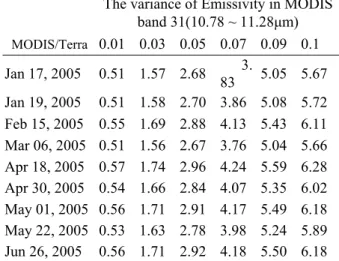
In order to understand the influences of surface emissivities in the LST retrieval, a dataset of MODIS/Terra acquired during Jan to Jun in 2005 under cloudless sky was used to examine the variation of LST with surface emissivities by the split-window algorithm.
The LST surface measurements from 12 ground stations of Central Weather Bureau in Taiwan are used for the reference data. The results show that the variations of LST can be larger than 2.5 ℃ when the variance of emissivity is 0.05, see also table 1. The significant error of the LST estimation can be introduced by an inaccurate surface emissivity is verified again in this study.
Therefore, it is an important role to extract correct surface emissivities for the accurate LST retrieval.
Table 1. Land surface temperature varied with the emissivities from MODIS data.
The variance of Emissivity in MODIS band 31(10.78 ~ 11.28μm)
MODIS/Terra 0.01 0.03 0.05 0.07 0.09 0.1
Jan 17, 2005 0.51 1.57 2.68 3.
83 5.05 5.67 Jan 19, 2005 0.51 1.58 2.70 3.86 5.08 5.72 Feb 15, 2005 0.55 1.69 2.88 4.13 5.43 6.11 Mar 06, 2005 0.51 1.56 2.67 3.76 5.04 5.66 Apr 18, 2005 0.57 1.74 2.96 4.24 5.59 6.28 Apr 30, 2005 0.54 1.66 2.84 4.07 5.35 6.02 May 01, 2005 0.56 1.71 2.91 4.17 5.49 6.18 May 22, 2005 0.53 1.63 2.78 3.98 5.24 5.89 Jun 26, 2005 0.56 1.71 2.92 4.18 5.50 6.18
2.3 Correction of Surface Emissivity
Assume the emissivities of MODIS channel 31 and 32 are equal to AVHRR channel 4 and channel 5, respectively. Under this assumption associated with the LST ground measurements, the correction factor of surface emissivities can be expressed as,
Ae ( ε31 )2 + Be ( ε31 ) + Ce = 0 (4)
where Ae, Be and Ce are the coefficients regressed from the datasets of MODIS data and LST ground measurements.
2.4 Datasets
There are three datasets used in this study. The first two datasets are the MODIS satellite dataset and its corresponding LST products around Taiwan area provided by NASA/GSFC, USA (hppt://rapidfire.sci.
gsfc.nasa.gov/) during Jan 2005 to Dec 2006. Because of the different observation time, the data of MODIS/Terra and MODIS/Auqa will be separated for the analyses of surface emissivities and LST estimation.
The other one is the ground measurements of LST from 12 ground stations of Central Weather Bureau in Taiwan in the same period of MODIS datasets (provided by the data bank for atmospheric research, NTU Taiwan).
The instruments of curved thermometer (as figure 1 shown) are used to measure the LST three times every day on the sites of ground stations.
Figure 1. The instrument of curved thermometer for the LST measurements.
3. RESULTS AND ANALYSES
3.1 The Correlations between Emissivities and NDVI The datasets of MODIS satellite and LST ground measurements in 2005 are used for the correction of surface emissivities estimation. Both annual and seasonal correction factors of surface emissivities in MODIS band 31 and 32 are considered due to the seasonal changes of NDVI values. The result of annual correction factors for MODIS/Auqa is illuminated in figure 2, and a good two order polynomial relationship exists between annual correction factor and NDVI. The seasonal correction factors also have good two order polynomial relationship to NDVI, see also table 2.
Figure 2. The regression results of annual correction factor of land surface emissivities in MODIS (a) band 31 and (b) band 32.
Table 2. The regressed formulas of seasonal correction factors of land surface emissivities in MODIS band 31.
Season
(2005) Formula Correlation
Coefficient Spring Fc31=6.9474x2-3.6877x+1.5403 0.91 Summer Fc 31=2.0422x2-1.5290x+1.3100 0.8
Fall Fc 31=2.0120x2-1.5709x+1.3680 0.78 Winter Fc 31=1.9191x2-1.4833x+1.3531 0.74 Annual Fc 31=2.3367x2-1.7461x+1.3806 0.78 Fc31 is the correction factor; x is NDVI value
3.2 LST Retrieved
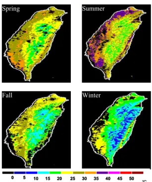
After the correction factors of land surface emissivities in MODIS band 31 constructed, the MODIS dataset was applied to retrieve the LST. The results are shown in table 3 when compared with ground measurements. The average errors of retrieved LST from MODIS data can be reduced more than 1 ℃ when the correction factors are introduced. Meanwhile, the overall errors are less than 3 ℃ indicating high practicability of the approach developed in this study. The application of LST retrieved from MODIS/Auqa data all over Taiwan area in different seasons are displayed in figure 3. The distributions of LST in different seasons are quite reasonable.
Table 3. The average errors of LST retrieved from different approaches. (unit: )
2005 2006 APPROACH Terra Aqua Terra Aqua
Mao et al. 6.4 4.3 5.9 3.6
(2005) Bhattacharya &
Dadhwal (2003)
6.4 7.0 7.2 7.1
LST Products
(NASA) 3.7 3.0 3.0 3.1
Correction
Factor 2.4 2.3 2.8 2.8
Figure 3. The LST retrieved from MODIS/Aqua data all over Taiwan area in Spring, Summer, Fall and Winter seasons.
4. DISCUSSIONS
An improved approach of LST retrieving with satellite data is presented in this study. The significant error of LST from the improper determination of surface emissivity can be reduced efficiently by introducing the correction factor of land surface emissivities. The results show high accuracy and facility of this approach after compared with ground measurements. Data should continue to be collected and analyzed so that the correction factors database can be improved further in raising the applicability.
ACKNOWLEDGEMENTS
This study was primarily supported by the National Science Council (grand No.: NSC 95-2752-M-008-005 - PAE;NSC 95-2111-M-008-038-AP5) of Taiwan. The
y = 2 .1 7 6 8 x2 - 1 .6 2 5 2 x + 1 .3 5 9 1 R = 0 .7 7
0 0 .2 0 .4 0 .6 0 .8 1 1 .2 1 .4 1 .6
0 0 .1 0 .2 0 .3 0 .4 0 .5 0 .6
y = 2 .3 3 6 7 x2 - 1 .7 4 6 1 x + 1 .3 8 0 6 R = 0 .7 8
0 0 .2 0 .4 0 .6 0 .8 1 1 .2 1 .4 1 .6
0 0 .1 0 .2 0 .3 0 .4 0 .5 0 .6
(a)
NDVI Values
Correction factor Fc
(b)
5
0 5 10 15 20 25 30 35 40 45 50
0 10 15 20 25 30 35 40 45 50
℃
Spring Summer
Fall Winter
authors thank DAAC/NASA, data bank for atmospheric research/NTU Taiwan and CSRSR/NCU Taiwan for their data providing.
REFERENCES :
Becker, F., and Li, Z. L., 1990, Towards a local split window method over land surface, International Journal of Remote Sensing, 11, 369-393.
Becker F., 1987, The impact of spectral emissivity on the measurement of land surface temperature from a satellite, Int. J. Remote Sensing, vol. 8, no. 10, pp. 1509–1522.
Bhattacharya, B. K., and Dadhwal, V. K., 2003, Retrieval and validation of land surface temperature (LST) from NOAA AVHRR thermal images of Gujarat, India, International Journal of Remote Sensing, Vol. 24, No. 6, 1197-1206.
Griend, A.A. van de. and Owe, M., 1993, On the relationship between thermal emissivity and the normalized difference vegetation index for natural surfaces. International Journal of Remote Sensing, 14, pp.
1119-1131.
Hook S. J., A. R. Gabell, A. A. Green, and P. S. Kealy, 1992, A comparison of techniques for extracting emissivity information from thermal infrared data for geological studies, Remote Sens. Environ., vol. 42, pp.
123–135.
Li Z.-L. and F. Becker, 1993, Feasibility of land surface temperature and emissivity determination from AVHRR data, Remote Sens. Environ., vol. 43, pp. 67–85.
Mao, K., Qin, Z., Shi, J., and Gong P., 2005, A practical split-window algorithm for retrieving land-surface temperature from MODIS data. International Journal of Remote Sensing, Vol. 26, No. 15, 3181-3204.
Ottle C. and M. Stoll, 1993, Effect of atmospheric absorption and surface emissivity on the determination of land temperature from infrared satellite data, Int. J.
Remote Sensing, vol. 14, no. 10, pp. 2025–2037.
Qin Zhihao, and Karnieli, A., 1999, Progress in the remote sensing of land surface temperature and ground emissivity using NOAA-AVHRR data. International journal of Remote Sensing, 20, 2367-2393.
Valor, E., and Casselles, V., 1995, Mapping of land surface emissivity from NDVI:Application to European, African, and South American areas. Remote Sensing of Environment, 57, 167-184.
Vidal A., 1991, Atmospheric and emissivity correction of land surface temperature measured from satellite using ground measurements or satellite data, Int. J. Remote Sensing, vol. 12, no. 12, pp. 2449–2460.
Wan, Z., Zhang, Y., Zhang, Q. and Li, Z.-L., 2002, Validation of the land-surface temperature products retrieval from Terra Moderate Resolution Imaging Spectroradiometer data. Remote Sensing of Environment, 83, pp. 163-180.
Ottle C. and M. Stoll, 1993, Effect of atmospheric absorption and surface emissivity on the determination of land temperature from infrared satellite data, Int. J.
Remote Sensing, vol. 14, no. 10, pp. 2025–2037.