AN INVERSION ALGORITHM FOR SOIL MOISTURE RETRIEVAL IN PASSIVE MICROWAVE REMOTE SENSING
Sungwook Hong and Inchul Shin
National Meteorological Satellite Center, Korea Meteorological Administration, [email protected]
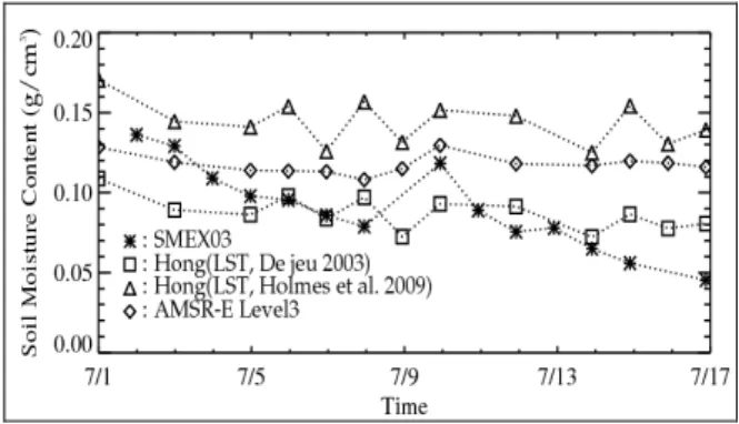
ABSTRACT ... Surface soil moisture is a key variable in describing water and energy exchanges at the land- atmosphere interface. Soil moisture and ocean salinity (SMOS) satellite mission and soil moisture active/passive (SMAP) mission are recently in progress for the global soil moisture retrieval. In this study, we present a unique inversion scheme of soil moisture retrieval based on characteristics of the polarized reflectivities and polarization ratio on the rough surfaces around Brewster angle. The proposed algorithm is validated using AMSR-E data and a series of field experiments (SMEX03) from 2 to 17 July, 2003 for Oklahoma. As a result, the proposed algorithm revealed that the retrieved soil moistures are within the reasonable range of the current AMSR-E soil moisture algorithms.
Consequently, the proposed inversion algorithm has an advantage of the least use of forward models irrespective of a priori information about the surface roughness and dielectric constants.
KEY WORDS: Soil moisture amount, inversion, passive microwave remote sensing
1. INTRODUCTION
In hydrology and meteorology, surface soil moisture is a key variable in describing water and energy exchanges at the land–atmosphere interface.Most studies on the microwave emission from soil and vegetation are based on polarization differences showed that the vegetation, topography, snow coverage and soil moisture do affect the estimates of land surface emissivity. Research on microwave remote sensing of soil moisture has focused on the forward modeling problem (Koike et al., 2000).
Currently, the AMSR-E sensor on NASA's Earth Observing System is widely used for global soil moisture retrieval algorithm (Njoku et al., 2003). In the soil moisture
algorithms, the emissivity is estimated using the surface temperature and the observed brightness temperature. After correcting this emissivity for vegetation and surface roughness, the dielectric constant is determined using the Fresnel equation. Finally, a dielectric mixing model is used to obtain the soil moisture.
In this study, we propose a unique inversion algorithm (hereafter referred to as Hong’s algorithm) of soil moisture on the basis of the differences in the polarizations of microwave radiation over land surfaces.
2. DATA AND METHOD
The AMSR-E onboard the NASA AQUA satellite is a
conically scanning total power passive microwave radiometer sensing microwave T
Bat 12 channels and 6 frequencies at incidence angle of 55.0°. In this research, the AMSR-E data at 6.9 GHz channel is used for the global retrieval with the ancillary AMSR-E data to screen out the permanent ice sheet, mountainous terrain, snow coverage, frozen grounds, precipitation, and RFI regions.
For the purpose of validation, we use the SMEX03 data obtained from 2 to 17 July, 2003 for Oklahoma.
Additionally, for the Oklahoma sites, T
Sextracted from Oklahoma Mesonet field stations (De Jeu, 2003) is also tested.
Vegetation optical depth is calculated using a relationship between the microwave polarization difference index (MPDI) and the vegetation optical depth τ , as suggested by Meesters et al. (2005):
⎟ ⎠
⎜ ⎞
⎝ ⎛ + + +
⋅
= cos θ ln ad ( ad )
2a 1
τ (1)
where a = [( R
R,H− R
R,V) / MPDI + R
R,V+ R
R,H] / 2 , d = ω /[ 2 ( 1 − ω )] , and MPDI is ( T
B,V− T
B,H) /( T
B,V+ T
B,H) .
On the basis of the rough reflectivity, the Hong approximation (Hong, 2009), and the characteristics of the polarization ratio around Brewster angle, the small- scale roughness σ can be estimated as follows (Hong, 2010a,b,c):
⎟ ⎟
⎠
⎞
⎜ ⎜
⎝
⋅ ⎛
≈
H R
V R
R R
, cos,
2
cos ln 4
θ