Selection of Convenient Route for Welfare-type Community Bus in Nagasaki City by Using GIS
Yoshiko Imaoka
Graduate School of Science and Technology, Nagasaki University 1-14 Bunkyo-Machi, Nagasaki 852-8521,Japan
Syouhei Yugeta
Graduate School of Science and Technology, Nagasaki University 1-14 Bunkyo-Machi, Nagasaki 852-8521,Japan
Keinosuke Gotoh
Graduate School of Science and Technology, Nagasaki University 1-14 Bunkyo-Machi, Nagasaki 852-8521,Japan
gotoh @civil.nagasaki-u.ac.jp
Abstract: The objective of this study is to discuss the future trend of the community bus. In doing so, we have selected Nagasaki City of Japan. Geographic Information Systems (GIS) is used for selection of the routes. In the present study we are going to add new parameters and new selection method.
As a result of the study, we have been able to identify some best possible and detailed routes for the community bus operation in Nagasaki City, which meets the requirement of the welfare community as well as general passengers.
Keywords: Community Bus, Geographic Information Systems.
1. Introduction
In Japan, the population of elderly people is increasing very rapidly. Therefore development of infrastructure facilities including transportation, road etc. to cope with this shift in population age group is needed. The traffic institution and transportation for aging society should also aim traffic system, which people of all ages can also use. This will enable future elderly people's participation in various social activities positively. Recently, public transportation vehicles are also being modified to facilitate the transportation of the elderly or the disabled person. Among the various public transportation means, bus is one of the most widely used means for people having no private transportation vehicle or living in mountain slopes or depopulated districts. In recent years, the community bus, which is close to the local community plays an important role as safe and useful transportation for the elderly and the physically handicapped the persons living in remote areas.
Nagasaki City has many areas along which a bus does not pass by slope, step and narrow path. In this city, the community bus "Ranran" is operating with the objective to reduce the traffic congestion in the city center, improvement of public communication and revitalization of central city area. But community bus from the view
point of welfare society to reduce the transportation problem of the elderly or the physically handicapped persons are not yet present in the city.
Accordingly, this study aims at discussing the future trend of the community bus and attempted to route selection by using GIS for the welfare-type community bus, which satisfies the need of elderly and physically handicapped persons in Nagasaki City. Conventional studies regarding public transportation selected route by evaluating the whole area without having particular standards. In this study, we attempted for route selection by fixing particular standards.
2. Variables and Route Selection Method
1) Variables Used for GIS Analysis
The variable used for GIS analysis is shown in table 1[1], [2], [3]. The community bus staffs of Dazaifu City and Munakata City helped us in the selection process of the variables by earlier reported data.
2) Route Selection Method
We have performed route selection through the following procedures:
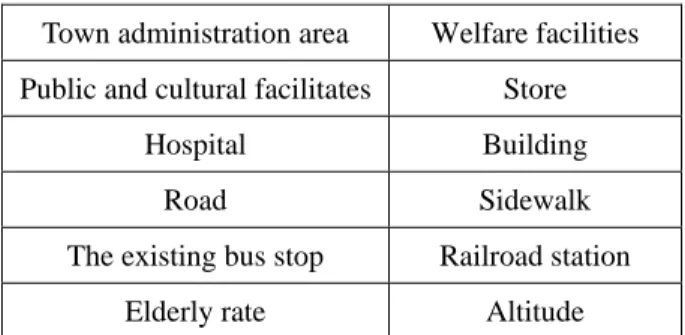
Table 1. The variables used for GIS analysis
Town administration area Welfare facilities Public and cultural facilitates Store
Hospital Building Road Sidewalk The existing bus stop Railroad station
Elderly rate Altitude
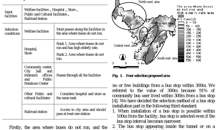
Firstly, the area where buses do not run, and the distribution of elderly rate (the proportion of those aged 65 and over) and altitude data are selected. The standard of the existing bus line is to place a bus stop within 100m [4]. The standard for elderly population rate is 25% or more in the town.
Secondly, the needs data of the user of Table 2 were inputted and were evaluated for the selected area. In addition to this, building data was inputted in order to assist the portion that does not have adequate facilities.
Thirdly, the road through which the minibus mainly used as a community bus can pass and sidewalk data are inputted. The road was extracted with total road width of 4.6m or more (two lane roads having 2.3m in each lane plus 0.5m as margin) where the minibus is mainly used as a community bus. We have taken these structures by following the standard prescribed in the Road Act.
Section 47 as a standard for construction.
These road data and sidewalk data were added up to check the existence of stairs. Then, selection of a detailed operation route was performed. We have decided the selection method of an operating route in the following third standard:
1. As it is generally considered that elderly people can walk up to 100m distance without resting, we tried to pass the route through all welfare facilities as far as possible.
2. When the above condition does not fulfilled, we tried to pass through the nearest road by 100m or more.
3. When two or more roads exist between facilities we have selected the roads passing through the more populated areas.
Fourthly, the bus stop was selected at intervals of 200m on the selected route. Bus stop is deleted if there is
Table 2. Input data and selection conditions
Input facilities
Welfare facilities、Hospital、Store、
Public and Cultural facilitates、
Railroad station
Welfare facilities Must passes along the facilities in the area where buses do not run.
Hospital, Store
Rank 1. Area where buses do not run and has high elderly rate.
Rank 2. Area where buses do not run.
Community center, City hall and itsbranch offices and Public Relations Center
Passes through all the facilities
Other Public and cultural facilitates
Considers hospital and store as the same rank
Selection conditions
Railroad station Access to city area and should pass at least one station
Fig. 1. Four selection proposed area
no or few buildings from a bus stop within 300m. We referred to the value of 300m because 91% of community bus user lived within 300m from a bus stop [4]. We have decided the selection method of a bus stop installation part in the following third standard:
1. When installation of a bus stop is possible within 100m from the facility, bus stop is selected even if the bus stop interval becomes narrower.
North-west area
2. The bus stop appearing inside the tunnel or on a bridge is moved or deleted.
3. New bus stop is avoided when the proposed bus stop matches with the existing bus stop.
Finally, route was developed with no changeover, if possible and can complete the loop in one hour with about 20km speed per hour.
3. Results
1) Selection of proposed area
According to the first procedure in the route selection method above, we have divided the area into four blocks as shown in Fig.1: central-east area, central-west area, north-west area, and south-east area. However, since the building of most southeast part areas are located within 300m from the existing bus stop, they are excluded from this proposed selection area. Accordingly we have carried out the analysis for the remaining three areas.
2) The results of selected area
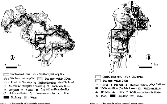
1. North-west area
The route selection result of North-west area is shown in Fig. 2. This area is operating as the connecting route as streetcar station running towards the city area, the JR line extended to the outskirts of the city, large shopping center and branch of various city offices are located in the eastern area. We selected the loop line which goes to eastern area through the welfare facilities which is the dotted area shown in Fig.2. Therefore, although some institutions left from the operation route, the loop line included most of these facilities. However, one trip
Central-east area
Central-west area
South-east area
Fig. 2. The result of a North-west area
towards this operation route is about 53km.
Then, the operation route was divided into two routes, northern part loop line (about 36km) and southern part loop line (about 32km).
Area A is constructed to go through the welfare facilities in the inland which is not included in the circulation route from selection conditions of Table 2.
And, in area B priority is given to the selection conditions of Table 2, the welfare facilities along which the existing bus line passes have left from the operation route. Moreover, in few places where the route overlaps the existing bus line, we have selected a different route to avoid duplication.
Finally, The bus stop became 194 in total for the northern part loop line and the southern part loop line.
(116 northern part loop lines, 109 southern part loop lines, among which 31 are common bus stops).
2. Central-west area
The result of Central-west area is shown in Fig. 3.
This area has the streetcar, the JR line, large shopping center, shopping street, etc. in the north-east area. We selected the loop line which goes through the northeast area by passing the residential area, welfare facilities, etc.
in southern area. Access to a station was made around the Nagasaki station with both the stations of JR line and streetcar (see area A in Fig. 3).
This area is the most important place for transportation.
Moreover, it will become convenient if the southern part having many buildings has a route passing through the houses district. But this could not be done as the route is hindered due to the existence of stairs and narrow roads.
This central-west area has almost all the facilities
A A
B B
Fig. 3. The result of a Central-west area
included within 100m of the selected route. The distance of a route is also suitable at about 13km.
The number of bus stops is 53. Almost all the buildings of this area are located within 300m from the bus stop, which also indicates the convenience of this route.
3. Central-east area
The result of a Central-east area is shown in Fig. 4.
This area has central urban area in the central area, and also has prefectural office, city office, commercial facilities, etc. On the other hand, welfare facilities are scattered widely. So we have selected the loop line, which goes to the central urban area by passing these welfare facilities.
All the welfare facilities of this area are located in the area without bus route. Therefore route selection was performed so that it might pass within 100m from those facilities as much as possible. Northern area has the area where buses do not run and higher elderly rate (see Fig.
1). However, the route by including only welfare facility in area A since there were few institutions and buildings.
Many facilities exist in the central urban area of area B.
However, since it is quite impossible to pass the route through all these institutions, we have decided to pass the route connecting city office, Hamanomachi commercial area via the prefectural office, citizen’s hall, and public hall. The route distance (about 29km) of the Central-east part area is somewhat long. However, it became the loop line, which passed through almost all the institutions and streetcar station. Since there are many buildings in the area , the number of bus stops became 117.
Fig.4 The result of a Central-east area
4. Conclusions
The rapid fall in the number of passengers commuting through buses due to increase in private car users are forcing many bus lines to stop operation. However, the bus is the best available secured means of transportation for the elderly population not possessing own car. And proper route selection for the bus to move becomes very essential in order to ensure optimum use by the users including elderly persons. This study is an attempt towards this goal to provide best possible route for the community bus in Nagasaki City from the viewpoint of
welfare community. The results of the study might provide important guidelines to the policymakers for selecting routes for the community bus in the city.
A
However, detailed study is needed in route selection by considering optimal location of bus stop, one-way road, and no entry for vehicles. If input for GIS data such as detailed road data, passage width, moving direction of one-way road, can be obtained, then the burden of field survey can be reduced and more exact route selection can be done through GIS. In addition to this, we have to take into consideration some additional factors such as slope for wheelchairs, low deck bus, holding grips, the operation time schedules such as consultation hours of the hospital, shopping activity, etc.
By considering all these above factors more effective and convenient route selection can be done.
B
In sloped city like Nagasaki maintenance of public transportation is quite difficult. In spite of this, the appeal of citizens to make the transportation facilities more convenient can be heard frequently. Therefore, we think that effective route selection for the community bus can play an active role in fulfilling the need of the citizens.
References
[1] ZENRIN Co., Ltd., 2003. Housing and District Map (Vector Data).
[2] Geographic Survey Institute, National Surveying and Mapping Organization of the Ministry of Load, Infrastructure and Transport 1998, Digital Map 50m Grid (Elevation).
[3] Geographic Survey Institute, National Surveying and Mapping Organization of the Ministry of Load, Infrastructure and Transport 1998, Digital Map 2500 (Spa tial Data Framewoak).
[4] Tsuchiya, M, Musashino City Traffic Measure Section, and Maniwa, K,. 1996. “M-bus” running successfully, Gyousei, Tokyo, pp.55-60, p.161 (in Japanese).