http://dx.doi.org/10.7848/ksgpc.2014.32.6.607
Comparative Analysis of the Multispectral Vegetation Indices and the Radar Vegetation Index
Kim, Yong-Hyun
1)· Oh, Jae-Hong
2)· Kim, Yong-Il
3)Abstract
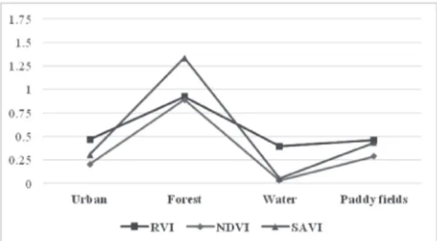
RVI (Radar Vegetation Index) has shown some promise in the vegetation fields, but its relationship with MVI (Multispectral Vegetation Index) is not known in the context of various land covers. Presented herein is a comparative analysis of the MVI values derived from the LANDSAT-8 and RVI values originating from the RADARSAT-2 quad-polarimetric SAR (Synthetic Aperture Radar) data. Among the various multispectral vegetation indices, NDVI (Normalized Difference Vegetation Index) and SAVI (Soil Adjusted Vegetation Index) were used for comparison with RVI. Four land covers (urban, forest, water, and paddy field) were compared, and the patterns were investigated. The experiment results demonstrated that the RVI patterns of the four land covers are very similar to those of NDVI and SAVI. Thus, during bad weather conditions and at night, the RVI data could serve as an alternative to the MVI data in various application fields.
Keywords : Multispectral Vegetation Index, Radar Vegetation Index, Quad-polarimetric SAR, Comparative Analysis
607 Original article
Received 2014. 11. 28, Revised 2014. 12. 09, Accepted 2014. 12. 30
1) Member, Dept. of Civil and Environmental Engineering, Seoul National University (E-mail: [email protected]) 2) Corresponding Author, Member, Dept. of Civil Engineering, Chonnam National University (E-mail: [email protected]) 3) Member, Dept. of Civil and Environmental Engineering, Seoul National University (E-mail: [email protected])
This is an Open Access article distributed under the terms of the Creative Commons Attribution Non-Commercial License (http://
creativecommons.org/licenses/by-nc/3.0) which permits unrestricted non-commercial use, distribution, and reproduction in any medium, provided the original work is properly cited.
1. Introduction
Lately, the trend in the area of spaceborne satellites has been satellite constellations. A satellite constellation is composed of various satellites, including the electro-optical and SAR satellites. Thus, more frequently, data acquisition is possible on the same AOIs (Areas Of Interest) (McNairn et al., 2009). Likewise, the KOMPSAT constellation consists of the KOMPSAT-2 & 3 (electro-optical), KOMPSAT-5 (SAR), and KOMPSAT-3A (electro-optical & thermal IR) satellites.
Accordingly, recent researches report that the integration or fusion of optical and SAR data might be beneficial due to their distinct features (Zhou et al., 2012) because
optical data allows the measurement of the reflectance of the land-covers and SAR data deliver useful geometric information without affected by weather conditions (Vaglio Laurin et al., 2013). In addition, multispectral data provide information on the chemical composition vegetation while the SAR scattering process is influenced by the structural elements of the vegetation. Therefore, comparative study of these data could be effective for various land-cover studies.
Among the various application fields of remote sensing,
vegetation indices derived from multispectral satellite data
are the primary sources of information for operational
vegetation monitoring (Baig et al., 2014; Zhou et al.,
2014). MVI is a key information source about vegetation
608
conditions and is very useful for the environmental issues. The use of MVI has been proposed for providing the vegetation conditions from different portions of the multispectral spectrum. Among the various MVIs, NDVI is a very popular and standard index (Gao, 1996; Rouse et al., 1974). It takes normalization forms that are the bases of most current indices, and is obtained by dividing the difference by the sum of the NIR (Near-InfraRed) and red reflectances (Jones and Vaughan, 2010). NDVI is increasingly being used for the indirect study of biophysical plant canopy properties (Teillet et al., 1997). It has some problems, however, due to external-factor effects such as soil background variations (Qi et al., 1994). To reduce the soil background effect, Huete (1988) proposed the use of soil adjustment factor L to account for the first-order soil background variation. This index is SAVI, and adjustment factor L varies with the vegetation density.
With regard to radar remote sensing, Kim and Van Zyl (2009) introduced an index for volume scattering media, such as vegetation canopies: RVI. They evaluated RVI by modeling a vegetation canopy as a collection of randomly oriented cylinders with different lengths and diameters.
RVI has been proposed as a method for monitoring the level of vegetation growth, particularly when time series data are available (Kim et al., 2012). Also, RVI would be less sensitive to both the incident angle and the changes in the environmental conditions. Recently, some researches demonstrated that RVI is a robust index for characterizing vegetation canopies and for the retrieval of the biophysical parameters of crops (Kim et al., 2014; Kim et al., 2012).
Despite the good results of RVI, it has to be considered that the backscatter recorded from a vegetated surface is a function of several physical properties: vegetation type, surface roughness, soil moisture, vegetation structure, and plant moisture content as well as sensor configuration (Koppe et al., 2013). Also, most of the RVI researches were conducted using a scatterometer rather than satellite sensors, and as such, there can be some uncertainties in the applicability of satellite-based RVI.
As mentioned earlier, two main sensor-type indices have been developed to estimate vegetation conditions. While the two approaches are quite complementary, the relationship
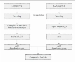
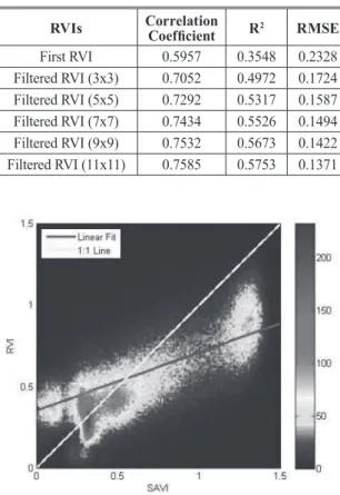
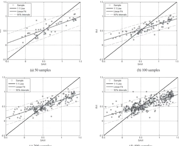
between MVI and RVI in the context of various land covers is not known. Also, due to the limited multi-sensor data, their relationship remains ambiguous. Additionally, the apparent similarity of seasonal trends in SAR signatures and MVI values does not imply a real relationship but an indirect or superficial relationship. One reason for the ambiguity using SAR sensors was the low spatial resolution but the latest C-band RADARSAT-2 can achieve the required high spatial resolution. This study did not aim to find accurate models to link MVIs to RVI data but to provide a base study comparing satellite-based C-band RVI with MVI. Therefore, the objectives of this paper are as follows: (1) to provide MVI and RVI data for comparison;
(2) to explore the MVI and RVI data patterns in the four land covers; and (3) to investigate the possibility of using the RVI data as an alternative to the MVI data. Towards these ends, the MVI data obtained from the LANDSAT-8 satellite and the RVI data obtained from the C-band quad- polarimetric RADARSAT-2 satellite, were compared. This paper is organized as follows. In section 2, the MVIs are briefly introduced, and in section 3, RVI is explained for comparative analysis. In section 4, the analysis results of four land covers are presented, and the patterns are discussed. Finally, conclusions are drawn in section 5.
2. Multispectral Vegetation Indices
The MVIs are usually dimensionless measures derived from radiometric data that are primarily used to indicate the amount of green vegetation. In this section, NDVI and SAVI are reviewed, and their characteristics are concisely discussed. Ideally, satellite-based MVIs should always be calculated based on the corrected surface reflectance.
Thus, to calculate the vegetation index, the digital numbers of the data were converted to surface reflectance using atmospheric correction module. In this study, to reduce the atmospheric effects and extract surface reflectance, the model QUAC (QUick Atmospheric Correction) was used for LANDSAT-8 imagery (Bernstein et al., 2012).
QUAC code performs atmospheric correction on multi- and
hyperspectral imagery spanning all or part of the visible
and near infrared-short wave infrared spectral range.
609 This is based on that empirical finding which the average
reflectance of diverse material spectra is essentially scene- independent. QUAC depends less on the atmospheric parameters and relatively easy to achieve the corrected surface reflectances.
2.1 Normalized difference vegetation index One important method of extracting biophysical characteristics from satellite sensors involves the use of vegetation indices. NDVI, which is the difference between the NIR and red bands divided by their sum, has been the most widely used index in various applications. NDVI (Rouse et al., 1974) is defined as
NIR RED NIR RED
NDVI ρ ρ
ρ ρ
= −
+ ( 1 )
(1 ) (
NIRNIR REDRED)
SAVI L
L
ρ ρ
ρ ρ
= − × +
+ + ( 2 )
8 2
HVHH HV VV
RVI σ
σ σ σ
= + + ( 3 )
(1)
where
NIR REDNIR RED
NDVI ρ ρ
ρ ρ
= −
+ ( 1 )
(1 ) (
NIRNIR REDRED)
SAVI L
L
ρ ρ
ρ ρ
= − × +
+ + ( 2 )
8 2
HVHH HV VV
RVI σ
σ σ σ
= + + ( 3 )
and
NIR RED NIR RED
NDVI ρ ρ
ρ ρ
= −
+ ( 1 )
(1 ) (
NIRNIR REDRED)
SAVI L
L
ρ ρ
ρ ρ
= − × +
+ + ( 2 )
8 2
HVHH HV VV
RVI σ
σ σ σ
= + + ( 3 )
are the reflectance values of the NIR and red bands, respectively.
NDVI is a basis form for most of the current indices applicable to both reflectance and radiance. Note that the sum of the NIR and red bands represents the average reflectance in this wavelength range. Division by this factor reduces the effect of non-uniform illumination and thus helps make for better comparability of the vegetation index across an image (Jones and Vaughan, 2010).
2.2 Soil-adjusted vegetation index
Huete (1988) found that the vegetation biophysical isolines in an NIR-red reflectance space are neither parallel to a soil line nor converge at the origin. SAVI was subsequently developed based on this general vegetation biophysical isoline behavior. Also, to reduce the soil background effect, SAVI uses soil adjustment factor L to account for the first- order soil background variation. SAVI (Huete, 1988) is defined as
NIR RED NIR RED
NDVI ρ ρ
ρ ρ
= −
+ ( 1 )
(1 ) (
NIRNIR REDRED)
SAVI L
L
ρ ρ
ρ ρ
= − × +
+ + ( 2 )
8 2
HVHH HV VV
RVI σ
σ σ σ
= + + ( 3 )
(2)
where
NIR REDNIR RED
NDVI ρ ρ
ρ ρ
= −
+ ( 1 )
(1 ) (
NIRNIR REDRED)
SAVI L
L
ρ ρ
ρ ρ
= − × +
+ + ( 2 )
8 2
HVHH HV VV
RVI σ
σ σ σ
= + + ( 3 )
and
NIR RED NIR RED
NDVI ρ ρ
ρ ρ
= −
+ ( 1 )
(1 ) (
NIRNIR REDRED)
SAVI L
L
ρ ρ
ρ ρ
= − × +
+ + ( 2 )
8 2
HVHH HV VV
RVI σ
σ σ σ
= + + ( 3 )
are the reflectance values of the NIR and red bands, respectively, and L is the soil adjustment factor. In this study, L=0.5 was used.
SAVI minimizes the soil brightness influences, which are
prominent in ratio-based vegetation indices such as NDVI (Jiang et al., 2006). Huete (1988) suggested that SAVI with L=0.5 successfully minimized the effect of soil variations in green vegetation compared to NDVI.
3. Radar Vegetation Index
In the microwave region of the electromagnetic spectrum, the intensity of the incident energy scattered by vegetation is primarily a function of the canopy architectures, such as the size, shape, and orientation of the canopy components and the dielectric properties. Also, the backscattered microwave is affected by the sensor configuration, such as the frequency, polarization, and incidence angle (Koppe et al., 2013).
To apply the index in various fields, an index should attempt to minimize the impact of the crop structure, incidence angle, and environmental conditions. RVI would be less sensitive to both the incidence angle and the changes in the environmental conditions. This polarimetric index is most suitable for monitoring the level of growth using time series observations. Few studies, however, have attempted to establish a relationship between RVI and the biophysical parameters (Kim et al., 2012). RVI generally ranges between 0 and 1 and is a measure of the randomness of the scattering. RVI is near zero for a smooth bare surface, and increases as a vegetation grows. RVI can only be calculated using the quad-polarimetric SAR or scatterometer and RVI (Kim and Van Zyl, 2009) is given by
NIR RED NIR RED
NDVI ρ ρ
ρ ρ
= −
+ ( 1 )
(1 ) (
NIRNIR REDRED)
SAVI L
L
ρ ρ
ρ ρ
= − × +
+ + ( 2 )
8 2
HVHH HV VV
RVI σ
σ σ σ
= + + (3) ( 3 )
where
NIR RED NIR RED
NDVI ρ ρ
ρ ρ
= −
+ ( 1 )
(1 ) (
NIRNIR REDRED)
SAVI L
L
ρ ρ
ρ ρ
= − × +
+ + ( 2 )
8 2
HVHH HV VV
RVI σ
σ σ σ
= and + + ( 3 )
NIR RED NIR RED
NDVI ρ ρ
ρ ρ
= −
+ ( 1 )
(1 ) (
NIRNIR REDRED)
SAVI L
L
ρ ρ
ρ ρ
= − × +
+ + ( 2 )
8 2
HVHH HV VV
RVI σ
σ σ σ
= + + are the co-polarization ( 3 )
backscattering cross-sections, and
NIR RED NIR RED
NDVI ρ ρ
ρ ρ
= −
+ ( 1 )
(1 ) (
NIRNIR REDRED)
SAVI L
L
ρ ρ
ρ ρ
= − × +
+ + ( 2 )
8 2
HVHH HV VV