미래 한국형 항법위성을 위한 위성항법메세지에 대한 연구
조중현
*, 이우경
**, 최남미
***, 백정호
*,
****A study on the navigation message contents of the future Korean navigation satellite
Jung Hyun Jo
*, Woo Kyoung Lee
**, Nammi Choe
***, and Jeongho Baek
*,
****요 약
현재까지 국내 위성항법 연구는 기존 위성항법체계기술을 활용한 연구가 주를 이루었으나, 새로운 위성항법 체계에 대한 연구도 점차 그 중요성이 부각되고 있다. 심지어 대한민국 독자적인 항법위성을 보유하자는 의견도 대두되었다. 지리적, 경제적, 기술적인 이유로 아직 수면 위로 떠오른 적은 없지만 자체 항법위성 관련 우주개발 로드맵이 제 1차 우주개발기본계획에 막연하게 제시되어 있다. 그러나 전세계적으로 4개의 전지국적 위성항법체계가 운영 중이거나 구축 중이고, 여러 개의 지역위성항법 시스템이 계획 중 에 있다. 특히 아시아에서 중국은 독자의 전지구적 위성항법시스템 (COMPASS을 2020년에 완성하고자 위성을 발사 중에 있으며, 일본은 지역위성항법 시스템인 QZSS(Quasi Zenith Satellite System)를 2013년 완성을 목표로 제작 및 발사하고 있다. 이제 대한민 국도 독자적인 위성항법시스템을 국내 우주개발 기술확보 및 항법안보를 위해서 꼭 개발해야 할 시기이다. 이 연구에서는 대한민국 자체의 위성항법시스템의 개발 여부나 그 개발 가능성을 논하지 않고, 다만 자체의 항법위성을 보유할 경우, 그 항법 메시지에 기존 의 정보 외에 어떤 종류의 정보를 실을 수 있는지 조사하여 보았다. 대한민국의 지리적, 경제적 특성상 지역항법위성체계가 첫 번째 항법위성의 탑재체가 될 가능성이 높다. 따라서 이 연구도 이에 준해서 이루어졌다.
Key Words : navigation satellite, navigation message, Space Development Roadmap, regional augmented system, navigational
payload.
ABSTRACT
Many studies relating the satellite navigation has been done by a relatively small research community in Korea. Most of domestic research has been focused on the application of the satellite navigation technology, but recently the topics of the next generation satellite navigation system are emphasized for its importance. Even opinions suggesting a future Korea’s own satellite navigation system are not that uncommon. Due to the geographic, economic, and technological reasons, it is not widely discussed yet. However, a development technical roadmap regarding the Korea’s own navigation satellite was established on the Korea Space Development Plan in general term. Currently four global navigation satellite systems are operating or being deployed. Several regional navigation satellite systems are in planning and development phase. Particularly in Asia, China has launched several satellites to complete their own global navigation satellite system, COMPASS until 2020.
Japan launched one satellite and has planned to launch rest of set until 2013. It is proper time to develop Korea’s own navigation satellite system to acquire the domestic space development technology and the security of navigational infrastructure. In this study, the validity or the feasibility of the Korea’s own satellite navigation system is not discussed;
rather the possibility and suitability of the additional information to the current operational navigation message is main target.
For the first payload of the future Korea’s satellite navigation satellite, a regional augmented system is more likely. This study also is focused on that aspect.
※ 이 논문은 기초기술연구회의 국가현안문제 해결형(NAP)과제인 “우주물체 전자광학 감시체계 기술개발”의 부분지원을 받아 수행되었음
*한국천문연구원 우주감시센터 ([email protected]), **COSMIC Project Office, University Corporation for Atmospheric Research, Boulder, CO 80303, USA,
***한국항공우주연구원, ****과학기술연합대학원대학교
접수일자 : 2012년 5월 21일, 수정완료일자 : 2012년 6월 19일, 최종게재확정일자 : 2012년 6월 25일
I. Introduction
We have seen a drastic expansion of the Global
Navigation Satellite System (GNSS) application field
in Korea for last two decades. However, all the
studies have been done by a relatively small research
community in Korea. Due to the geographic, economic, and technological reasons, Korea’s own GNSS satellite seems to be a far-fetched until lately.
Recently a development technical roadmap regarding the Korea’s own navigation satellite was established in the Korea Space Development Plan in general term. Also, several planning projects have been done for the national GNSS technology roadmap.
The Global Positioning Satellite (GPS) system by the United States has been a sole completed global space based navigational signal provider since its initiation of full operational capability in 1994. The United States government introduced new signal and band, L5, L2C as a result of modernization and the improvement of the system. The Russian counterpart, GLObal NAvigation Satellite System (GLONASS) had never reached its full operational capability until now. The European Galileo navigation satellite system witnessed the launch of its first pair in October, 2011. The Chinese COMPASS global navigation satellite system, formerly known as Beidou will be completed until 2020. In September 2010, Japan launched its first navigation satellite for their regional augmented navigation satellite system for GPS. Several countries are planning to have their own regional navigation satellite system.
The growth of the GNSS application market and the social dependency of GNSS related technology have been increased since its introduction to Korea.
As the public needs for the GNSS technology, the GNSS infrastructure, and the GNSS application area reaches out to demand the acquisition of the domestic navigation satellite system.
In this study, the possibility and suitability of the additional information to the current operational navigation message is primarily discussed; The validity or the feasibility of the Korea’s own satellite navigation system is not discussed. For the first payload of the future Korea’s satellite navigation satellite, a regional augmented system is more likely.
The navigation message of QZSS should be carefully analyzed as primary counterpart.
In chapter 2, the contents of the navigation message in the satellite signals of the GPS, GLONASS, GALILEO, and QZSS is reviewed. In chapter 3, the current status of Korean GNSS community is described. In chapter 4, necessary
components and some extra for the future Korean GNSS are suggested. Conclusions are given in chapter 5.
Ⅱ. Navigation Messages in Several GNSS
The basic principle of the positioning by GNSS is triangulation. One of the necessary information to fix the unknown position of the user is the precise position data of the GNSS satellites as the reference points for the triangulation. The design of orbit traced by the GNSS satellite has been selected to maximize the availability with adequate temporal and spatial resolution. The precise positions of the GNSS satellites can be calculated from the navigation message generated by the control segment from the observation data collected by the monitoring station, transferred to navigation satellite, and broadcasted back to the Earth.
Navigation message is the most vital information what any GNSS receiver can get from the navigation satellite signal. In this message, user can find the information of satellite’s health, clock, ephemeris, time, epoch, ionospheric correction, and other corrections. GNSS satellite also transmits short term and long term codes over several carriers for several levels of positioning.
Since the first launch of GPS satellite in 1978, several navigation satellite systems have been established. Each system is using similar type of navigation data to provide users with acquisition data for positioning, timing, and planning observations. In this chapter, code and carrier related topics (signal type, sequence, hierarchical frame structure, check sum bit, every flags, data duration, PRN, encryption, corrections, etc.) are not discussed. The contents of navigation messages are sole interest of this study.
1. GPS
The GPS Interface Control Document (ICD) defines
the requirements related to the interface between the
Space Segment of the GPS and User Segment. The
GPS ICD 200 was originally released in 1983 and was
finally open to public in 1997. It has been revised and
updated for several times [1]. In this document, the
characteristics and the specification of the GPS signals are well described. It is not that obvious to separate non-navigation data from the super-frame of the GPS navigation messages. Some of the flags, bit data, formatted word, indirectly related parameters, carrier, and codes can be used for navigation purposes. However, in this study clearly identified parameters as the navigation message in ICD-200 are only considered. The contents of GPS navigation message consists of time scale, several epochs, SV health, satellite clock information, ionosphere information, satellite ephemeris and harmonic coefficients, precision degraded satellite almanac, code information, signal delay, and etc.
Table 1 shows the content of GPS navigation messages.
Table 1. Navigation message in GPS signals
Category Parameter Remark
Signal
SA flag AS flag L2 code selection SV accuracy
Clock distortion Y code C/A, P URA index
Satellite health SV health Signal health
NAV data 4 bits
Time
Week number Issue date clock Issue date ephemerides Curve fit interval.
Almanac ref. week UTC parameter Almanac time parameter clock Reference time
Clock corrections 3 parameters.
Group delay Estimated delay L1-L2
Ionospheric 8 harmonic coefficient Klobuchar model
ephemeris
Keplerian elements Rate of change Harmonic parameters almanac Reduced set of clock &
ephemeris data
2. GLONASS
The navigation message transmitted by the GLONASS and GLONASS-M satellites within GLONASS navigation signal is purposed to provide users with requisite data for positioning, timing and planning observations [4].
The navigation message consists of immediate data and non-immediate data. The immediate data relate to the GLONASS satellite which broadcasts given RF navigation signal and include followings [3]:
z
enumeration of the satellite time marks
z
difference between onboard time scale of the satellite and GLONASS time
z
relative difference between carrier frequency of the satellite and its nominal value
z
ephemeris parameters and the other parameters
The non-immediate data contains almanac of the system including [3]:
z
data on status of all satellites within space segment (status almanac)
z
coarse corrections to onboard time scale of each satellite relative to GLONASS time(phase almanac)
z
orbital parameters of all satellites within space segment (orbit almanac);
z
correction to GLONASS time relative to UTC(SU) and the other parameters
Table 2. Navigation message in GLONASS signals
Category Parameter Remark
Immediate Information
SV health Health flag 1stbit Signal Range accuracy
Freq. Dev. Predicted
Time
Reference time Interval index Control parameter Current date L1-L1 Δtime Age of ephemeris
Operation mode
SV clock
correction SV time correction GLONASS time
Flags
Data updating Time odd & even numberofSV Ephemeris Slot number GLONASS / M
Almanac Existence
SV ephemeris
xyz position xyz velocity xyz acceleration
Ref.PZ-90
Non-Immedia te Information
time
GLONASS time scale correction
4 yr interval GPS time correction Calendar day no.
UT1-UTC coeffi.
SV clock correction Ref.
UTC(SU) Ref.
GLONASS time
Almanac
Keplerian orbit elements
Corrections Draconian period Signal Carrier freq. no.
SV health Unhealthy SV orbit No. of SV
In Table 2, you can see the specific items in the GLONASS navigation messages. The GLONASS navigation message has very distinctive features for the orbit related parameters. The GPS navigation message uses the Keplerian orbital elements for the almanac and the ephemerides of the GPS satellite.
However, the GLONASS navigation message uses the state variables in Cartesian rectangular coordinates for the ephemeris and the Keplerian orbital elements for the almanac. The GLONASS navigation message includes more terms in partial derivatives of orbital elements than GPS does. But the correction information about the ionospheric delay of RF signal by using a physical model is not included in the GLONASS navigation message.
3. European Galileo System
The navigation data of European Galileo System contain all the parameters that enable the user to perform positioning service. Those are stored on board each satellite with the validity duration and broadcast worldwide by all the satellites of the Galileo constellation [4].
The 4 types of data needed to perform positioning are as follows:
z
Ephemeris: needed to indicate the position of the satellite to the user receiver
z
Time and clock correction parameters: needed to compute pseudo-range
z
Service parameters: needed to identify the set of navigation data, satellites, and indicators of the signal health.
z
Almanac: to indicate the position of all the satellites in the constellation with a reduced accuracy.
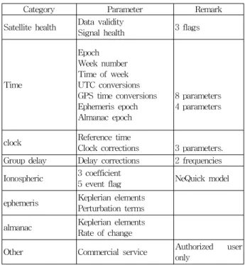
Table 3 shows the content of European Galileo navigation message.
The contents of the Galileo navigation message are very similar to those of GPS. Galileo system has its own definition of time system differed from United States’ system. Thus, several parameters to define the Galileo time system and to transform the time system to other systems are included in the navigation message. Also, Galileo system is using different ionospheric model to compensate the radio frequency (RF) signal delay.
Table 3. Navigation message in Galileo signals
Category Parameter Remark
Satellite health Data validity
Signal health 3 flags
Time
Epoch Week number Time of week UTC conversions GPS time conversions Ephemeris epoch Almanac epoch
8 parameters 4 parameters
clock Reference time
Clock corrections 3 parameters.
Group delay Delay corrections 2 frequencies Ionospheric 3 coefficient
5 event flag NeQuick model ephemeris Keplerian elements
Perturbation terms almanac Keplerian elements
Rate of change
Other Commercial service Authorized user only
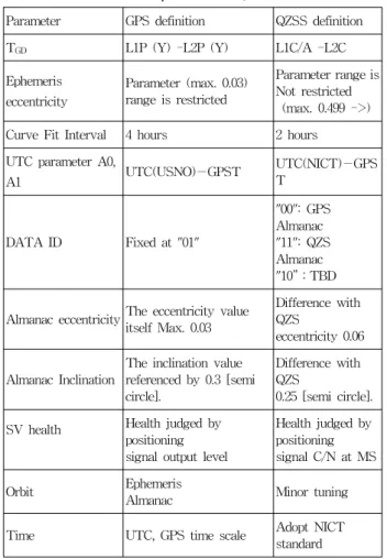
4. QZSS
The QZSS satellites transmit six positioning signals: L1C/A signal, L1-SAIF signal, L1C signal, L2C signal, LEX signal and L5 signal. Four of these, L1C/A, L1C, L2C and L5 are known as positioning availability enhancement signals in the sense that they complement the existing Global Navigation Satellite System (GNSS). The remaining two signals, L1-SAIF and LEX are known as positioning performance enhancement signals in the sense that they enhance performance through the transmission of existing GNSS differential data and integrity data concerning GNSS signals as determined by QZSS.[5]
The QZSS Navigation Messages for each signal (number of bits, scale factor, parameter range, units) are designed to preserve interoperability with GPS to the greatest extent possible. However, based on differences in the conditions unique to GPS and QZSS (QZS satellite orbit conditions, etc.), in some cases QZSS Navigation Messages cannot be expressed using the same definitions as those for GPS.
Moreover, in order to provide QZSS with added value
not present in GPS, some content has been
intentionally defined differently from GPS. For this
content, the unique QZSS definitions provided in
Table 4 must be used [5].
Table 4. Selected Navigation Message Parameter Definition Unique to QZSS.
Parameter GPS definition QZSS definition
TGD L1P (Y) -L2P (Y) L1C/A -L2C
Ephemeris eccentricity
Parameter (max. 0.03) range is restricted
Parameter range is Not restricted (max. 0.499 ->) Curve Fit Interval 4 hours 2 hours UTC parameter A0,
A1 UTC(USNO)-GPST UTC(NICT)-GPS
T
DATA ID Fixed at "01"
"00": GPS Almanac
"11": QZS Almanac
"10”:TBD
Almanac eccentricity The eccentricity value itself Max. 0.03
Difference with QZS
eccentricity 0.06
Almanac Inclination
The inclination value referenced by 0.3 [semi circle].
Difference with QZS
0.25 [semi circle].
SV health Health judged by positioning signal output level
Health judged by positioning signal C/N at MS
Orbit Ephemeris
Almanac Minor tuning
Time UTC, GPS time scale Adopt NICT standard
Ⅲ. Future Korean Navigation Satellite System
1. GNSS in Korea
Since the first introduction of GPS receiver in the middle of 1980s in Korea, the GNSS application area has been studied and researched by every level of industries, education institutes, and research institutes. In early 90s, Korea Astronomy and Space Science Institute founded a permanent GPS observation site. Also, many other institute had set up several dozens of GPS continuously operation reference station. An International GNSS Service (IGS) Global Data Center has been in operation on Korea Astronomy and Space Science Institute since 2006. For general GNSS users, millions of car navigation terminal and low-end GPS receiver have been sold. For the professional survey, high accuracy GPS receiver is now an essential tool. In the application of the intelligent traffic system, a high
accuracy positioning system is in demand. However, any national level GNSS project has not been pursued except the National Differential GPS (NDGPS) network around Korean peninsula completed in 2001.
The size of Korean GNSS research community in the ground and user segments has been expanded for last two decades. Most of future fundamental program relating the Korean navigation satellite for these two segments can be accomplished without big difficulties. However, some level of international cooperative work must be needed in the space segment in both software and hardware. Over all, the Korea GNSS community has the capacity of the introduction of its own GNSS satellite.
2. Government Plan
Until the “Basic Integrated Development plan of the National Satellite Navigation System” was established, no large scale organized effort to set up a specific plan or technological roadmap had been existed [6].
Also, “Space Development Promotion Law” was enacted by the former Ministry of Science and Technology. By this plan and the law, an introduction of a navigation satellite can be achieved. A preliminary program plan with a rough budget list has been submitted but no conclusion and schedule.
With the launch of a new government in 2008, a re-designed national technological plan also contains the satellite navigation system field. A certain effort by the government to introduce Korea navigation satellite in any form will be continued.
3. Justification of Introducing Korean GNSS
This is the most sensitive and the difficult part for
Korean GNSS community and Korean government to
own its navigation satellite. Any full-scale official
cost-benefit analysis of any type of the Korean
navigation satellite has not been done. The future
GNSS market in Korea and its vicinity must be
analyzed. Then the type of future Korean GNSS
should be carefully studied in technological feasibility
and optimal benefit for end-user. However, a regional
augmentation system will be more likely in most
aspect, economically, technologically, and market-wise.
Ⅳ. A Proposed Navigation Message set of the future Korean GNSS
As you can see in Table 1, 2, 3, and 4, most of major component of GNSS navigation message like time data, almanac and ephemeris from GPS, GLONASS, Galileo, and QZSS is not quite unique rather similar to each other. The vital information necessary to determine the precise position of the GNSS satellite naturally should be identical in different form. The design of the other navigation message contents beside satellite orbit related information depends definitely on the type of the navigation satellite system. If the type of the future Korean GNSS is decided, then the specific supplement message set can be added to the basic set. The supplement message is also very restricted.
The future Korean own global navigation satellite system is not feasible for geographical, economical, practical, and even political reasons. A regional independent navigation satellite system like Chinese original Beidou-1 or an augmented navigation satellite system similar to Japanese QZSS is a strong candidate configuration.
With the regional independent navigation satellite system, we need to design all the navigation messages from scratch to satisfy the requirements quite different in many parts from the requirements of the global counterpart. For the space segment, the configuration of a satellite constellation, the designs of code, signal, message contents, time system, ephemeris, and the satellite hardware are the main components to be studied and developed. For the user segment, we cannot use most of current GPS receivers. Practically, it is absolutely not cost-effective for Korea with only 220,000 square kilo-meter land area and seas near it to develop a full scale regional independent navigation satellite system.
The development of a new augmented navigation satellite system for Korean peninsula is more feasible option. The GPS system is in full operational capability, Russian GLONASS system is completed again (2010), European Galileo system will ready around 2020 tentatively, and Chinese COMPASS will also be ready until 2020. At least one of these four GNSS can be selected for the basis provider of a navigation service, or more than one can be. Then an
augmented navigation system will provide the GNSS correction data, supplement data, additional Korean standard time information, and other performance enhancement information.
The area to be covered by the future Korean GNSS can use one of existing global GNSS or both.
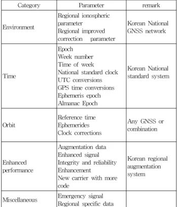
Therefore the candidates of the supplement messages for the future Korean GNSS Satellites can be categorized as in Table 5.
Table 5. Suggested Navigation Message Parameter for the future Korean navigation satellite system
Category Parameter remark
Environment
Regional ionospheric parameter
Regional improved correction parameter
Korean National GNSS network
Time
Epoch Week number Time of week National standard clock UTC conversions GPS time conversions Ephemeris epoch Almanac Epoch
Korean National standard system
Orbit
Reference time Ephemerides Clock corrections
Any GNSS or combination
Enhanced performance
Augmentation data Enhanced signal Integrity and reliability Enhancement
New carrier with more code
Korean regional augmentation system
Miscellaneous Emergency signal Regional specific data
The suggested message items in Table 5 are a
brief list of possible supplement message adding to
the general GNSS navigation message. The first item
in Table 5 is about the correction parameter of the
delayed signal due to the ionosphere and other
environmental factors. Several time related information
are also necessary to maintain the precision and
integrity of the navigation satellite system. The
parameters of the transformations between KST or
Korean navigation satellite system specific time and
Universal Coordinated Time or other GNSS times are
listed in the second row of Table 5. To define the
Korean regional augmented navigation satellite
system, most of designing effort should be put on the
fourth (“Enhanced performance”) and fifth
(“Miscellaneous”) row of Table 5. Several satellite
based augmented systems have been in the market already like WAAS or QZSS. Customization of the parameters for the Korean augmented system must be executed to ensure the success of the operation.
On-going crowded situation of GNSS must be considered.
V. Conclusion
The basic navigation message of the future Korean GNSS ought to be very similar to the currently defined one of other space based augmented GNSS because making a totally new set of GNSS navigation message is not a simple job and unnecessary. The supplement navigation message can be variable to the final design of the system. However, it must be carefully designed, tested, verified, and proved due to the geographical aspect of Korea. Also, the specific target market, policy, management aspect, and system structure of Korean GNSS have to be studied ahead of time. With the expected difficulties, Korean GNSS navigation message can be defined to meet the specification of the system.
With the inception of second revised Korea Space Development Plan in 2012 and future National Technology Incubating Plan for the regional satellite navigation system will pave the way to the next stage for the Korean GNSS community.
Acknowledgement
This study was partially supported by the National Agenda Project “Development of electro-optic space surveillance system” funded by Korea Research Council of Fundamental Science & Technology (KRCF) and Korea Astronomy and Space Science Institute (KASI). Author acknowledges that this study was based on “What can we put into the navigation message of the future Korean navigation satellite? Or can we?” from the proceedings of JC-SAT 2008 by same author.
References
[1] “Navstar GPS Space Segment/Navigation User Interfaces”, ARINC Research Corporation, Interface Control Document, April 2000
[2] J. J. Spilker Jr., “GPS Navigation Data”, Ed. B. W.
Parkinson and J. J. Spilker, Jr., Global Positioning System: Theory and Applications Volume 1, 1996, pp.121-176.E.
[3] “GLONASS Interface Control Document”, Coordination Scientific Information Center, 2002.
[4] “Galileo Open Service Signals in Space Interface Control Document Draft 0”, European Space Agency/Galileo Joint Undertaking”, 2006.
[5] “Interface Specification for QZSS”, Japan Aerospace Exploration Agency, 2008.
[6] “Basic Integrated Development plan of the National Satellite Navigation System”, National Science and Technology Council, 2005.
[7] “Space Development Promotion Law”, Korea Ministry of Science and Technology, 2007.
저자
조 중 현(Jung Hyun Jo) 정회원
․1986년 2월:연세대학교 천문기상학과 (학사)
․1988년 2월:연세대학교 천문기상학과 (석사)
․2002년 8월 : Auburn University 항공우주공학과(박사)
․2005년 11월~현재 : 한국천문연구원
․2006년 3월~현재 : 과학기술연합대학원대학교 부교수 <관심분야> : 궤도공학, GNSS, 시스템 이론, 우주감시
이 우 경(Woo Kyoung Lee)
․2002년 2월:연세대학교 천문우주학 (학사)
․2004년 2월:연세대학교 천문우주학 (석사)
․2011년 2월 : 과학기술연합대학원 대학교 천문우주과학(박사)
․2003년 11월~2011월 12일 : 한국천문연구원
․2011년 9월~현재 : NCAR 박사후연수원
<관심분야> : GNSS, Radio Occultation, 우주환경
최 남 미 (Nammi Choe)
․1987년 2월:연세대학교 천문기상학 (학사)
․1990년 8월:연세대학교 천문기상학 (석사)
․1996년 5월 : The University of Texas at Austin 항공우주공학(석사)
․2003년 8월 : Auburn University 항공우주공학과(박사)
․2004년 12월~2007년 1월: 과학기술부 사무관
․2007년 7월~현재 : 한국항공우주연구원 <관심분야> : 우주정책, GNSS, 우주법
백 정 호(Jeongho Baek)