Vulnerability Assessment to Climate Change and Spatio-Temporal Information
Woo-Kyun LEE
*, Hyun-Ah Choi
**, Han-Bin Kwak
*, Sungho Choi
*, Guishan Cui
*, Jae-Gyun Byun
*, Seongjin Yoo
**
Department of Environmental Science and Ecological Engineering, Korea University, Seoul, 136-713, Korea
*
Department of Climatic Environment, Korea University, Seoul, 136-713, Korea [email protected]
ABSTRACT: Climate change has influenced on various sectors including ecosystem, water resource, natural hazards and health and so on. Thus, it is essential to more accurately assess climate change impact and prepare adaptation strategy. However, it is difficult to assess for climate change impact on various sectors with integrated form due to various data format by sectors. In this study, we prepared criteria and indicators for assessing climate change impact and integrated GIS. We suggest a guideline to assess vulnerability of each sectors to climate change based on integrated spatio-temporal information.
KEY WORDS: climate change, spatio-temporal information, vulnerability, adaptation
1. INTRODUCTION
The Fourth Assessment Report (AR4) of the Intergovernmental Panel on Climate Change (IPCC), states unequivocally that the global climate is warming(IPCC, 2007a, b). The impacts of climate change are not evenly distributed, in part due to the differentiated nature of hazards in different parts of the globe, but also due to differences in the ability to cope with and adapt to the negative effects and harness beneficial effects of climate shocks and stresses. The common generic conclusion is that those exposed to the most severe hazards are also those least able to cope with the associated impacts (Smit et al., 2001; AfDB et al., 2003; Adger et al., 2003).
In addition vulnerability assessment is a key concept linking research and climate change adaptation to climate change. It has been approached and interpreted in different ways, and conceptualized in particular along ecological and social lines (Adger, 2006; Chambers, 1989; O’Brien et al, 2007; Prowse, 2003). From an ecological perspective, vulnerability can be understood through the frequency and magnitude of a system’s response to an external event, such as a hazard, defined in poverty terms as a risk of inability to cope with a shock, leading to catastrophe (Hulme and Shepherd, 2003).
However, most of vulnerability assessment was based on descriptive analysis using non-spatial data. The Korean is affected by the monsoon climate and the features of complex peninsula (Im et al., 2006). It shows characterized spatial variability of temperature and precipitation. In this study, we tried to analyze vulnerability of ecosystem, forest fire, water supply, land slide and flooding with the help of spatial analysis of GIS-based spatial data. The approach for spatial vulnerability analysis suggested in this study was proven to be suitable for preparing spatially specific adaptation
strategies to climate change.
2. MATERIAL AND METHOD 2.1 Vulnerability assessment to climate change
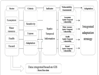
To assess for climate change impact on various sectors, we set up the criteria. Vulnerability criteria is sensitivity, expose, adaptation (Han, 2007). And then we suggested integrated form and indicators (Figure 1).
Figure 1. Vulnerability assessment structure
2.2 Spatio-temporal information setup
Spatio temporal information data is integrated 5km x
5km raster data based on GIS (Figure 2). In addition,
vulnerability assessment approaches assessment on
current climate – 30years (1977~2006) annual average
temperature (℃) and precipitation (mm).
Figure 2. Spatio-temporal information data 2.3 Vulnerability assessment
Using indicators, vulnerability assessment can be estimated as,
Vulnerability = (Sensitivity x Expose) / Adaptation (1) The calculation represents normalize value from indicators. In this case, vulnerability has been 0-1 value in sectors. It could be integrated assessment.
Normalize value = (X-Xmin)/(Xmax-Xmin) (2)
X: indicatorXmin: Minimum value of indicator Xmax: Maximum value of indicator
3. RESULTS AND DISCUSSIONS
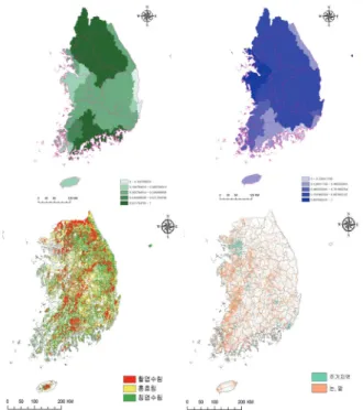
Results from vulnerability assessment indicate that water resource vulnerability output is presented flood and drought vulnerability. Yeongsan Basin estimated vulnerable to flood. Vulnerable administration unit appears to Jeollabuk-do, respectively (Figure 3a). And Drought vulnerable basin is Ahnsung, Gyeonggi-do administration unit (Figure 3b).
(a) (b)