─ 135 ─
오대산 국립공원 계방산 일대 삼림식생의 군락분포에 관한 연구
김창환*・오장근1・강은옥2・유칠선2・임진근2
전북대학교 생태조경디자인학과, 1국립공원관리공단, 2전북대학교 대학원 생태조경디자인학과
Community Distribution on Mountain Forest Vegetation of the Gyebangsan Area in the Odaesan National Park, Korea. Kim, Chang-Hwan*, Jang-Geun Oh1, Eun-Ok Kang2, Chil-Sun Yun2and Jin-Keun Lim2(Department of Ecology Landscape Architecture-Design, Chonbuk National University; 1Korea National Park Service, Gondeok-dong, Mapo-gu, Seoul 121-717, Korea; 2Department of Ecology Landscape Architecture-Design, Graduate School of Chonbuk National University)
Abstract The mountain forest vegetation of Gyebangsan (1,577 m) in Odaesan National Park is classified into deciduous broad-leaved forest, mountain valley forest, coniferous forest, subalpine coniferous forest, sub- alpine deciduous forest, plantation forest, and other vegetation which includes Actinidia argute community and agricultural land. As for the number of communities distributed in the each forest vegetation which were catego- rized by the physiognomy classification, deciduous broad-leaved forest had 33 communities, mountain valley forest 41 communities, coniferous forest 8 communities, subalpine coniferous forest 4 communities, subalpine deciduous forest 2 communities, plantation forest 6 communities and other vegetation 4 communities. Regard- ing the distribution rate of communities in the vegetation, in the deciduous broad-leaved forest. Quercus mon- golica community accounted for 80.226% with 30,909,942.967 m2, followed by Quercus variabilis community of 2.771% with 1,067,479.335 m2. 55.463% of deciduous broad-leaved forest in the Gyebangsan had Quercus mongolica as a dominant or second dominant species. In the mountain valley forest, Fraxinus rhynchophylla - Juglans mandshurica community accounted for 10.955%. And there were ten mixed communities having Fraxinus rhynchophylla and upper layer at a similar level of coverage, taking up 32.776%. In the coniferous forest, Pinus densiflora and the community living with Pinus densiflora accounted for 100%, showing that the coniferous forest has the community with Pinus densiflora as a dominant species at upper layer. For other vegetation, subalpine coniferous forest had a total of four communities including Abies holophylla - Quercus mongolica community, and accounted for 4.980% of vegetation area of Odaesan National Park. Two communi- ties including Betula ermani - Cornus controversa community were found in the subalpine deciduous forest, taking up 0.006% of total vegetation area of Odaesan National Park. Regarding plantation forest, Larix leptolepis was planted the most with 51.652%, followed by Betula platyphylla var. japonica with 38.975%, and Pinus koraiensis with 7.969%. These three species combined accounted for 98.565%. In conclusion, the forest vege- tation found in the Gyebangsan of Odaesan National Park has Quercus mongolica as a dominant species at the top layer. A lot of other communities related with this species are expected to be quickly replaced due to vegeta- tion succession and climatic causes. Therefore, Quercus mongolica is expected to become the main species in the deciduous broad-leaved forest, Fraxinus rhynchophylla, Juglans mandshurica and Fraxinus mandshurica
ISSN: 2288-1115 (Print), 2288-1123 (Online)
Manuscript received 25 June 2014, revised 20 July 2014, revision accepted 23 July 2014
* Corresponding author: Tel: +82-63-850-0736, Fax: +82-63-850-0735, E-mail: [email protected]
ⓒ The Korean Society of Limnology. All rights reserved.
This is an open-access article distributed under the terms of the Creative Commons Attribution Non-Commercial License (http://creativecommons.org/licenses/by-nc/3.0/), which permits unrestricted non-commercial use, distribution, and reproduction in any medium, provide the original work is properly cited.
서 론
계방산(37�42′15′′N~127�30′00′′E)은 지리적으로 우 리나라 동북부에 위치하고 있으며 강원도 평창군 진부 면과 홍천군 내면의 경계에 있다. 계방산 북쪽에는 설악 산 (해발고도 1,708 m), 남쪽으로는 태백산 (해발고도 1,657 m)을 이어주는 태백산맥의 중간지점에 위치하고 소계방산(해발고도 1,490 m), 오대산(해발고도 1,563 m), 황벽산(해발고도 1,407 m), 백적산(해발고도 1,141 m), 태기산(해발고도 1,261 m), 방태산(해발고도 1,444 m) 등 1,000 m 이상의 준봉들이 연결되어 있다(Hwang et al., 2013).
이 지역의 최근 6년(2001~2006)간 연평균 기온은 1.6�C, 연평균 최고기온 평균값과 최저기온의 평균값은 각각 17.3�C와 5.1�C이었으며, 평균연교차는 12.2�C로 나타났다. 한편 연평균강수량은 1,661.8 mm로 나타났으 며, 2006년에 2,140.8 mm로 최고 강수량과 2001년 1,135.9 mm로 최저 강수량을 각각 기록하였으며, 7~9 월에 연강수량의 50% 이상이 집중적으로 내리며, 일교 차도 크게 나타났다(Hongcheon county, 2008; Kim et al., 2010)
계방산(해발고도 1,577 m)지역의 식생은 산지낙엽활 엽수림대가 발달하여 계곡 등 일부 지역을 제외하고는 신갈나무가 우점하고 사면 저지대 및 계곡에는 물푸레 나무, 들메나무, 층층나무 등이 주로 분포한다. 계방산을 포함한 오대산 국립공원은 중부아구의 식물구계와 냉온 대 중부의 식물군계의 특징을 보이고 있어 한반도 중부 지역의 전형적인 식물군락의 분포와 종조성적 특징을 나타내고 있다(Lee et al., 1996).
오대산과 관련된 조사 및 연구는 최근까지 Lee (1971), Park and Oh (1971), Lee et al. (1998), Lee (2000a, b), Yun et al. (2010), Kim et al. (2010) 등에 의하여 지속적으로 이뤄져 왔다. 그러나 본 연구 지역인 계방산 지역에 범 위를 한정하여 조사된 연구는 Hwang et al. (2013)에 의 한 연구 외에는 거의 이뤄지지 않아 오대산 국립공원의 식물상 및 식생과 관련된 지역적 특징뿐만 아니라 지질
∙지형적 특징 등이 반영된 관리가 어려운 실정이다.
따라서 국립공원관리공단에서는 1 : 5,000 축척의 생태 자연도 정밀화 사업의 일환으로 국립공원 자원모니터링 기본조사 자료의 활용성을 높이고 국립공원 의사결정 도구로써 신뢰성을 높이기 위한 고축척 식생 전자지도 의 필요성에 의하여 식생에 대한 정밀조사 및 현존식생 도 제작을 실시하였다. 정밀식생도 제작은 국립공원 경 계 1 : 5,000 정밀임상도, 특별보호구역지도, 수치지도, 항 공영상의 원시자료를 연구 목적에 맞게 가공 변환하여 사용하였다. 따라서 기존 식생연구 및 식생도 제작에서 주로 사용한 1 : 25,000의 지형도를 이용한 조사에 비해 보다 정밀한 조사가 수행된 결과 중 상관대분류로 세분 한 식물군락에 대한 현존식생도 및 식물군락 분포 현황 에 따른 식생의 특징을 분석한 것이다.
따라서 본 연구는 오대산 국립공원의 계방산 일대 현 존 삼림식생에 대한 정밀조사를 실시하여 식생천이 등 을 분석함으로써, 계방산 일대 자연생태계 보전을 위한 기초자료로 제공하고자 한다.
재료 및 방법
1. 조사범위
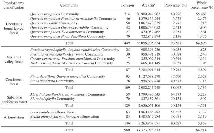
오대산 국립공원의 식생을 두로봉 일대, 노인봉 일대, 계방산 일대의 3개 주봉을 중심으로 하여 보다 정밀한 분석을 위하여 현존식생을 세분하였다(Fig. 1). 본 연구 에서는 세분된 3개 지역 중 계방산 일대를 조사지역으 로 설정한 후 현존식생도와 군락의 분포현황을 분석하 였다(Fig. 2).
2. 식생조사도면 제작 1) 식생조사도면 제작
(1) 식생조사도면
영상자료 및 수치지형도 등 참조자료를 활용하여 삼 림과 비삼림 지역, 삼림 내 활엽수림, 침엽수림, 혼효림 등 대분류 수준의 식생 상관분류를 실시하였다. 이를 정 밀식생조사 시 참고할 수 있도록 식생조사도면을 작성 in the mountain valley forest. Around the border line between deciduous broad-leaved forest and mountain valley forest, highly humid valley area is expected to be quickly taken up by Cornus controversa and Fraxinus mandshurica, and the slope area by Quercus mongolica. However, in the subalpine coniferous forest, the dis- tribution rate of deciduous broad-leaved trees is expected to increase due to climate warming.
Key words: classification, forest vegetation, Odaesan, physiognomy, Quercus mongolica, Pinus densiflora
∙출력하였으며, 국립공원 경계 1 : 5,000 정밀임상도, 특별 보호구역, 수치지도, 항공영상의 원시자료를 목적에 맞게 가공 변환하여 중첩하여 제작하였다. 좌표계는 GRS80 중부원점으로 통일하여 작성하였다.
(2) 작성기준 및 분류체계
본 연구에서 식생조사도면 작성기준은 환경부∙국립 환경과학원 정밀현존식생도 제작사업 수행 시 적용한 작성 기준에 따라 식생조사도면을 작성하였으며(Min- istry of Environment∙National Institute of Environmental Research, 2006) 식생조사도면 작성 시에는 영상 및 수 치지도를 활용하여 분류 가능한 범위 내에서 활엽수림, 침엽수림, 혼효림, 암벽식생, 기타식생의 5가지 내용으로 분류하였다.
3. 현존식생도 제작
1) 위치보정 및 자료변환
입수한 참조자료 중 Bessel 타원체 기준 좌표체계로 되어 있는 데이터는 세계측지계로 좌표변환을 실시하여 활용하였고, 영상자료는 국토지리정보원에서 제공받은 정사편위 완료 영상으로 위치보정 없이 사용하였다. 또 한 참조자료를 활용한 식생 외곽경계 및 내부경계를 분 류한 후 기 작성된 내장산 국립공원 정밀식생도 GIS-DB 속성을 참고로 하여 식생속성을 입력하였다.
2) 현장식생조사용 도면
식생대분류 결과와 항공사진, 수치지형도 및 참조자료 를 이용하여 식생조사도면 출력용 이미지 파일작성을 실시하였다. 도면은 식생조사도면, 참고도면, GPS 도면 등으로 구분하여 작성하였다.
4. 식생조사
2013년 3월부터 2014년 1월까지 1 : 5,000의 지형도 및 항공영상자료를 참고하여 오대산 국립공원 지역을 Braun-Blauquet (1964)의 식물사회학적 조사방법과 환 경부의 제3차 전국자연환경조사의 식생조사 지침을 참 고하여 조사하였다(Ministry of Environment, 2009).
결과 및 고찰
1. 상관대분류에 따른 군락 분포
오대산 국립공원 내 계방산(해발고도 1,577 m), 소계 방산(해발고도 1,490 m) 일대의 삼림식생은 입지의 지 형적 특성에 따라 산지삼림식생, 평지삼림식생, 기타식생 으로 나타났다.
이 지역 일대의 산지삼림식생은 산지낙엽활엽수림, 산 지습성림, 산지침엽수림, 아고산침엽수림, 아고산활엽수
Fig. 1. Location of Gyebangsan area in the Odaesan National Park.
Durobong Birobong
Dongdaesan Noinbong
Sowhangbyungsan
Cheonmabong
Maebong
0 2 4 6 8 km
N
W E
S Gyebangsan
Fig. 2. Actual vegetation map of Gyebangsan area in the Odaesan National Park.
0 600 1,200 2,400 3,600
Meters N
S
W E
림, 식재림으로 세분되었으며, 기타식생은 다래군락, 경작 지 등으로 세분되었다. 상관대분류에 의하여 구분된 각 각의 삼림식생을 구성하고 있는 분포군락수는 산지낙엽 활엽수림 32개 군락, 산지습성림 41개 군락, 산지침엽수 림 8개 군락, 아고산침엽수림 5개 군락, 아고산활엽수림 2개 군락, 식재림 6개 군락, 기타식생 4개 군락이 조사 되었다(Tables 2~9).
계방산 일대 삼림식생의 95개 군락 중 주요 상관대분 류별 분포면적 1% 이상은 16개 군락으로 전체 84.914%
를 차지하고 있으며(Table 1), 군락분포 면적은 1% 이하 군락은 전체 면적 15.086%, 79개 군락으로 조사되었다 (Tables 2~9). Table 1의 상관대분류별로 볼 때 활엽수 림은 산지낙엽활엽수림과 아고산활엽수림으로 대별되는 데 산지낙엽활엽수림은 분포면적 1% 이상 군락이 6개로 조사되었으며, 대부분 신갈나무군락이 우점하고 있다. 또 한 신갈나무- 물푸레나무군락, 신갈나무- 굴참나무군락, 신갈나무- 소나무군락 등이 분포하고 있는 것으로 조사 되었다. 아고산활엽수림은 분포면적이 1% 미만의 군락 이 2개 조사되었으며, 사스래나무와 이와 혼생하는 군 락이 분포하고 있다.
산지습성림은 물푸레나무- 가래나무군락, 층층나무- 들
메나무군락, 물푸레나무- 고로쇠나무군락, 가래나무- 층층 나무군락 4개 군락이 1% 이상 분포 면적을 차지하고 있 어 계방산 일대 산지 계곡은 대부분이 물푸레나무- 가래 나무군락, 층층나무- 들메나무군락 등에 의하여 우점되어 있음을 알 수 있다.
침엽수림은 산지침엽수림과 아고산침엽수림으로 대별 되는데 산지침엽수림은 대부분 소나무가 우점하고 있다.
또한 소나무- 신갈나무군락, 소나무- 들메나무군락, 소나 무- 굴참나무군락 등 소나무와 상층부 식피율이 비슷한 혼생림의 경우 천이의 진행과 함께 참나무속 수종으로 빠르게 군락이 대체될 것으로 보이며, 소나무군락 역시 시간의 경과와 함께 분포면적은 크게 감소할 것으로 판 단된다. 그러나 아고산침엽수림은 기후적 영향을 크게 받아 천이 경향에 의한 군락 대체보다는 기후적 요인의 변화에 따라 낙엽활엽수와 혼생할 것으로 보여 낙엽활 엽수림의 분포면적은 증가할 것으로 예상된다 (Lim, 2009; Choi et al., 2010).
한편 계방산 일대의 식재림은 사면 저지대의 마을, 경 작지, 도로와 연접된 부분에 일본잎갈나무가 식재되어 있다.
결론적으로 오대산 국립공원 계방산 일대의 산림식생
Table 1. Communities of ›1% distribution area in the 95 communities of Gyebangsan area in the Odaesan National Park.
Physiognomy
Community Polygon Area (m2) Percentage (%) Whole
classification percentage (%)
Quercus mongolica Community 214 30,909,942.967 80.226 55.463
Quercus mongolica-Fraxinus rhynchophylla Community 46 1,379,133.244 3.579 2.475
Quercus variabilis Community 50 1,067,479.335 2.771 1.915
Quercus mongolica-Quercus variabilis Community 42 1,006,754.052 2.613 1.806 Quercus mongolica-Tilia amurensis Community 27 870,052.462 2.258 1.561 Quercus mongolica-Pinus densiflora Community 70 822,843.574 2.136 1.476
Total 449 36,056,205.634 93.583 64.696
Fraxinus rhynchophylla-Juglans mandshurica Community 25 905,396.236 10.955 1.625 Fraxinus rhynchophylla-Acer mono Community 30 858,491.719 10.388 1.540 Cornus controversa-Fraxinus mandshurica Community 7 855,062.514 10.346 1.534 Juglans mandshurica-Cornus controversa Community 25 666,041.145 8.059 1.195
Total 87 3,284,991.614 39.748 5.894
Pinus densiflora-Quercus mongolica Community 93 1,127,638.270 47.690 2.023
Pinus densiflora Community 76 954,607.478 40.373 1.713
Total 169 2,082,245.748 88.063 3.736
Abies holophylla-Quercus mongolica Community 59 1,799,493.545 64.773 3.229
Abies holophylla Community 70 837,157.561 30.134 1.502
Total 129 2,636,651.106 30.134 4.731
Larix leptolepis afforestation 63 1,860,166.787 51.652 3.338
Betula platyphylla var. japonica afforestation 83 1,403,642.784 38.975 2.519
Total 146 3,263,809.571 90.627 5.857
Total 980 47,323,903.673 - 84.914
Deciduous borad leaved
forest
Mountain valley forest
Coniferous forest
Subalpine coniferous forest
Afforestation
은 신갈나무가 최상층부의 우점종으로 구성되어 있으며, 이들 종과 혼생군락을 이루고 있는 군락들은 천이 및 기후적 요인들에 의하여 군락 대체가 매우 빠르게 일어 날 것으로 보인다. 산지낙엽활엽수림은 신갈나무, 산지 습성림은 가래나무, 들메나무, 산지낙엽활엽수림과 산지 습성림의 경계부 중 습도가 높은 계곡부는 층층나무, 들 메나무, 사면부는 신갈나무로 대체가 빠르게 일어날 것 으로 보인다. 그러나 아고산 식생은 기후온난화 등에 의 하여 점차적으로 낙엽활엽수의 분포 비율이 증가할 것 으로 보인다.
2. 산지삼림식생
1) 산지낙엽활엽수림
계방산 일대 산지낙엽활엽수림은 능선부, 산지사면 상부
와 중부에 분포하고 있으며, 전체 조사면적 55,730,653.433 m2 중 38,528,681.877 m2으로 약 69.134%를 차지하고 있어, 상관대분류에 의한 산지산림식생 중 가장 넓은 면 적을 차지하고 있다.
이 일대는 신갈나무, 굴참나무, 피나무, 찰피나무와 혼 생하여 군락을 형성한 것은 총 33개 군락으로 구분되어 졌다(Table 2).
조사된 33개 군락 중 최상층에 1개 종이 우점하는 군 락은 신갈나무가 214개 polygon, 산지삼림식생 전체면 적의 55.463%로 가장 분포역 및 분포비율이 높았으며, 굴참나무군락이 50개 polygon, 산지삼림식생 전체면적 의 1.915%, 찰피나무군락이 1개 polygon, 산지삼림식생 전체면적의 0.005%로 3개 군락이 분포하고 있다. 2종이 최상층에서 혼생하고 있어 혼생군락을 형성하고 있는 군락 중 1% 이상의 분포 비율을 나타내고 있는 군락은
Table 2. Plant communities of deciduous borad leaved forest by physiognomy classification of Gyebangsan area in the Odaesan National Park.
Community Polygon Area (m2) Percentage (%) Whole
percentage (%)
Quercus mongolica Community 214 30,909,942.967 80.220 55.463
Quercus mongolica-Fraxinus rhynchophylla Community 46 1,379,133.244 3.579 2.475
Quercus variabilis Community 50 1,067,479.335 2.770 1.915
Quercus mongolica-Quercus variabilis Community 42 1,006,754.052 2.613 1.806
Quercus mongolica-Tilia amurensis Community 27 870,052.462 2.258 1.561
Quercus mongolica-Pinus densiflora Community 70 822,843.574 2.136 1.476
Quercus mongolica-Abies holophylla Community 29 478,672.212 1.242 0.859
Quercus variabilis-Quercus mongolica Community 14 336,090.818 0.872 0.603
Quercus mongolica-Kalopanax plctus Community 17 296,055.088 0.768 0.531
Quercus mongolica-Acer mono Community 7 229,806.606 0.596 0.412
Quercus mongolica-Juglans mandshurica Community 4 229,283.750 0.595 0.411
Quercus mongolica-Fraxinus mandshurica Community 4 218,747.715 0.568 0.393
Tilia mandshurica-Fraxinus mandshurica Community 1 126,786.311 0.329 0.227
Tilia mandshurica-Ulmus davldlana var. japonica Community 3 85,428.121 0.222 0.153
Tilia amurensis-Quercus mongolica Community 2 51,155.181 0.133 0.092
Tilia amurensis-Fraxinus rhynchophylla Community 1 50,727.435 0.132 0.091
Quercus mongolica-Betula ermani Community 5 50,578.810 0.131 0.091
Quercus variabilis-Abies holophylla Community 3 41,466.028 0.108 0.074
Quercus mongolica-Cornus controversa Community 2 37,428.458 0.097 0.067
Quercus mongolica-Larix leptolepis Community 3 34,369.073 0.089 0.062
Quercus serrata-Carpinus laxiflora Community 1 32,686.240 0.085 0.059
Quercus variabilis-Pinus densiflora Community 2 31,497.125 0.082 0.057
Tilia mandshurica-Fraxinus rhynchophylla Community 2 25,851.405 0.067 0.046
Quercus mongolica-Betula costata Community 3 22,793.251 0.059 0.041
Quercus mongolica-Carpinus laxiflora Community 2 19,292.603 0.050 0.035
Quercus mongolica-Actlnldla arguta Community 1 14,412.787 0.037 0.026
Quercus mongolica-Betula schmidtii Community 1 13,931.276 0.036 0.025
Betula costata-Fraxinus mandshurica Community 1 11,563.071 0.030 0.021
Quercus mongolica-Tilia mandshurica Community 1 11,704.688 0.030 0.021
Magnolla sleboldll-Cornus controversa Community 1 9,468.727 0.025 0.017
Quercus serrata-Fraxinus rhynchophylla Community 1 7,481.984 0.019 0.013
Tilia amurensis-Cornus controversa Community 1 5,197.480 0.013 0.009
Tilia mandshurica Community 1 2,970.827 0.008 0.005
Total 562 38,531,652.704 100.000 69.137
신갈나무- 물푸레나무군락이 1,379,133.244 m2, 3.579%, 신갈나무- 소나무군락이 822,843.574 m2, 2.136%, 신갈 나무- 굴참나무군락이 1,006,754.052 m2, 2.613가 조사 되었다. 전체 산지낙엽활엽수림 32개 중 2개 이상의 수 종이 비슷한 식피율로 혼생하고 있는 혼생군락은 30개 군락이 조사되었다.
1개 종이 우점하는 3개 군락은 신갈나무군락이 30,909,942.967 m2의 55.463%로 가장 높은 분포 비율로 조사되었고, 굴참나무군락이 1,067,479.335 m2의 1.915%
으로 전체의 57.378%를 차지하고 있었으며, 2종이 혼생
하는 군락은 42.622%로 조사되었다. 2종이 혼생하는 군 락은 신갈나무- 물푸레나무군락이 1,379,133.244 m2, 2.475%로 가장 높은 비율을 보였으며, 신갈나무- 굴참나 무군락이 1.806%, 신갈나무- 소나무군락 1.476 등의 순 으로 분포하였다.
전체 33개 군락 중 신갈나무와 혼생림을 구성하는 군 락은 17개 군락으로 10.292%를 차지하고 있어 신갈나 무 1종이 우점하는 신갈나무군락을 포함하면 계방산일 대 산지낙엽활엽수림의 65.755%는 신갈나무가 우점 또 는 차우점종으로 분포하고 있음을 알 수 있다. 굴참나무
Table 3. Plant communities of mountain valley forest by physiognomy classification of Gyebangsan area in the Odaesan National Park.
Community Polygon Area (m2) Percentage (%) Whole
percentage (%) Fraxinus rhynchophylla-Juglans mandshurica Community 25 905,396.236 10.955 1.625
Fraxinus rhynchophylla-Acer mono Community 30 858,491.719 10.388 1.540
Cornus controversa-Fraxinus mandshurica Community 7 855,062.514 10.346 1.534
Juglans mandshurica-Cornus controversa Community 25 666,041.145 8.059 1.195
Fraxinus rhynchophylla-Quercus mongolica Community 15 387,423.478 4.688 0.695
Cornus controversa-Juglans mandshurica Community 3 378,986.450 4.586 0.680
Cornus controversa Community 25 323,497.977 3.914 0.580
Fraxinus rhynchophylla-Actlnldla arguta Community 10 316,120.838 3.825 0.567
Acer mono-Fraxinus rhynchophylla Community 17 312,107.528 3.776 0.560
Cornus controversa-Acer mono Community 4 309,459.520 3.744 0.555
Fraxinus rhynchophylla-Tilia mandshurica Community 9 307,070.607 3.715 0.551
Fraxinus rhynchophylla-Fraxinus mandshurica Community 12 291,178.207 3.523 0.522
Cornus controversa-Fraxinus rhynchophylla Community 6 280,084.339 3.389 0.503
Acer mono-Quercus mongolica Community 18 251,555.082 3.044 0.451
Fraxinus rhynchophylla-Tilia amurensis Community 11 230,970.815 2.795 0.414
Fraxinus rhynchophylla-Kalopanax plctus Community 6 182,435.073 2.207 0.327
Juglans mandshurica-Fraxinus rhynchophylla Community 6 173,137.170 2.095 0.311
Acer mono-Tilia amurensis Community 7 151,923.558 1.838 0.273
Acer mono Community 14 125,560.788 1.519 0.225
Fraxinus rhynchophylla-Cornus controversa Community 6 122,386.938 1.481 0.220
Fraxinus mandshurica-Fraxinus rhynchophylla Community 5 101,118.663 1.224 0.181
Cornus controversa-Populus maxim Community 1 70,924.193 0.858 0.127
Fraxinus mandshurica-Cornus controversa Community 5 66,764.763 0.808 0.120
Fraxinus mandshurica-Acer mono Community 2 61,451.118 0.744 0.110
Fraxinus rhynchophylla Community 9 60,612.325 0.733 0.109
Juglans mandshurica Community 4 54,711.095 0.662 0.098
Acer mono-Juglans mandshurica Community 2 51,471.246 0.623 0.092
Populus koreana-Tilia amurensis Community 1 49,011.116 0.593 0.088
Juglans mandshurica-Actlnldla arguta Community 3 48,296.321 0.584 0.087
Cornus controversa-Tilia amurensis Community 4 44,439.850 0.538 0.080
Juglans mandshurica-Tilia amurensis Community 2 41,376.026 0.501 0.074
Fraxinus rhynchophylla-Pinus densiflora Community 2 29,701.276 0.359 0.053
Juglans mandshurica-Fraxinus mandshurica Community 1 25,651.952 0.310 0.046
Juglans mandshurica-Populus maxim Community 1 25,010.570 0.303 0.045
Acer mono-Cornus controversa Community 1 24,374.871 0.295 0.044
Fraxinus mandshurica-Tilia mandshurica Community 1 22,442.411 0.272 0.040
Fraxinus mandshurica-Quercus mongolica Community 2 20,603.683 0.249 0.037
Fraxinus rhynchophylla-Ailanthus altlsslma Community 2 11,888.151 0.144 0.021
Cornus controversa-Tilia mandshurica Community 2 10,254.198 0.124 0.018
Quercus allena-Juglans mandshurica Community 1 8,763.354 0.106 0.016
Fraxinus mandshurica Community 1 6,841.997 0.083 0.012
Total 308 8,264,599.161 100.000 14.830
군락과 혼생하는 군락은 2개 군락, 0.660%, 찰피나무와 혼생하는 군락은 3개 군락, 0.426%로 나타났다.
2) 산지습성림
계방산 일대의 산지습성림은 산지사면 하부와 계곡에 주로 분포하고 있으며 전체 조사면적 55,730,653.433 m2 중 8,246,599.161 m2으로 약 14.830%를 차지하고 있어 상관대분류에 의한 산지삼림식생 중 산지낙엽활엽수림 분포면적에 이어 두번째로 넓은 면적을 차지하고 있다.
조사된 군락은 층층나무- 들메나무, 물푸레나무- 고로 쇠나무, 고로쇠나무- 가래나무, 가래나무- 층층나무 등 총 41개 군락이 조사되었다(Table 3).
41개 군락 중 2개 이상의 수종이 군락을 이루는 혼생 군락은 36개 군락으로 조사되었다. 산지습성림을 구성하 는 41개 군락의 분포비율을 보면 물푸레나무- 가래나무 군락이 전체의 10.955%를 차지하고 있으며, 물푸레나무 와 상층부의 식피율이 비슷하여 혼생군락을 이루고 있 는 군락은 10개 군락으로 전체의 32.766%를 차지하고
있다. 따라서 물푸레나무 군락과 관련된 군락은 산지습 성림 전체의 43.721%로서 계방산 일대 산지습성림 군 락은 대부분 물푸레나무가 우점하고 있거나 군락의 우 점종으로 분포하고 있다. 또한 이외 산지습성림에서 층 층나무- 들메나무군락 10.346%, 가래나무- 층층나무군락 8.059% 등이 조사되었다.
3) 산지침엽수림
계방산 일대의 산지침염수림은 산의 능선부 및 사면 상부와 산의 저지대에 주로 분포하고 있으며, 계방산 조 사지역 전체의 4.243%를 차지하고 있다. 조사된 군락은 8개 군락으로 소나무- 신갈나무군락이 전체의 47.690%
로서 대부분의 산지침염수림은 소나무와 이 군락의 혼 생군락이 우점하는 양상을 나타내고 있다. 2종이 상층부 에서 비슷한 식피율로 혼생하고 있는 군락은 소나무- 들 메나무군락(4.559%), 소나무- 굴참나무(3.441%), 소나무 - 찰피나무군락(1.576%) 등이 조사되었다(Table 4). 이러 한 혼생림은 향후 천이의 진행과 함께 참나무속 수종으
Table 4. Plant communities of coniferous forest by physiognomy classification of Gyebangsan area in the Odaesan National Park.
Community Polygon Area (m2) Percentage (%) Whole
percentage (%)
Pinus densiflora-Quercus mongolica Community 93 1,127,638.270 47.690 2.023
Pinus densiflora Community 76 954,607.478 40.373 1.713
Pinus densiflora-Fraxinus mandshurica Community 5 107,792.109 4.559 0.193
Pinus densiflora-Quercus variabilis Community 6 81,354.017 3.441 0.146
Pinus densiflora-Juglans mandshurica Community 3 40,040.708 1.693 0.072
Pinus densiflora-Tilia mandshurica Community 1 37,260.315 1.576 0.067
Pinus densiflora-Cornus controversa Community 1 13,474.494 0.570 0.024
Pinus densiflora-Populus maxim Community 1 2,325.153 0.098 0.004
Total 186 2,364,492.544 100.000 4.243
Table 5. Plant communities of subalpine coniferous forest by physiognomy classification of Gyebangsan area in the Odaesan National Park.
Community Polygon Area (m2) Percentage (%) Whole
percentage (%)
Abies holophylla-Quercus mongolica Community 59 1,799,493.545 64.842 3.229
Abies holophylla Community 70 837,157.561 30.166 1.502
Abies holophylla-Quercus variabilis Community 8 79,989.068 2.882 0.144
Taxus cuspldata Community 1 58,544.350 2.110 0.105
Total 138 2,775,184.524 100.000 4.980
Table 6. Plant communities of subalpine deciduous forest by physiognomy classification of Gyebangsan area in the Odaesan National Park.
Community Polygon Area (m2) Percentage (%) Whole
percentage (%)
Betula ermani-Cornus controversa Community 1 71,583.293 89.514 0.128
Betula ermani Community 2 8,385.496 10.486 0.015
Total 3 79,968.789 100.000 0.143
로 매우 빠르게 군락이 대체될 것으로 보인다.
4) 아고산침엽수림
우리나라 아고산대수림은 아고산활엽수림과 아고산침 엽수림으로 대별되며, 제4차 전국자연환경조사 지침서 상의 현존식생도 상관명 범례(Ministry of Environment
∙National Institute of Environmental Research, 2012)에 는 아고산활엽수림은 사스래나무군락, 사스래나무- 전나 무군락, 사스래나무- 굴참나무군락, 사스래나무- 분비나무 군락, 분비나무- 사스래나무군락, 꽃개회나무군락의 6개 군락과 아고산침엽수림은 구상나무, 주목, 전나무, 잣나 무, 노간주나무, 눈향나무, 분비나무, 눈측백나무, 눈잣나 무 등과 관련된 군락 등 19개 군락이 표기되었다.
본 연구대상지인 오대산 계방산 일대의 아고산 침엽 수림은 전나무- 신갈나무군락, 전나무군락, 전나무- 굴참 나무군락, 주목군락 총 4개 군락이 조사되어, 우리나라 중부지역의 아고산침엽수림의 식생 특징을 나타내고 있 다. 이들 4개 군락은 오대산 국립공원의 전체 식생면적 의 4.980%를 차지하고 있으며, 계방산과 소계방산 정상
부에 집중적으로 군락을 이루고 있다. 4개 군락 중 전나 무- 신갈나무군락이 64.842%를 차지하고 있으며, 전나 무군락이 30.166%, 전나무- 굴참나무군락이 2.882%로 조사되었다(Table 5).
5) 아고산활엽수림
아고산 활엽수림은 사스래나무군락, 사스래나무-층층 나무군락 총 2개 군락이 조사되어, 우리나라 중부지역의 아고산활엽수림의 식생 특징을 나타내고 있다. 이들 2개 군락은 오대산 국립공원의 전체 식생면적의 0.143%를 차지하고 있으며, 계방산과 소계방산 정상부에 군락을 이루고 있다. 2개 군락 중 사스래나무- 층층나무군락이 89.514%로 우점하고 있으며, 사스래나무군락이 10.486
%로 조사되었다(Table 6).
6) 식재림 및 기타 식생
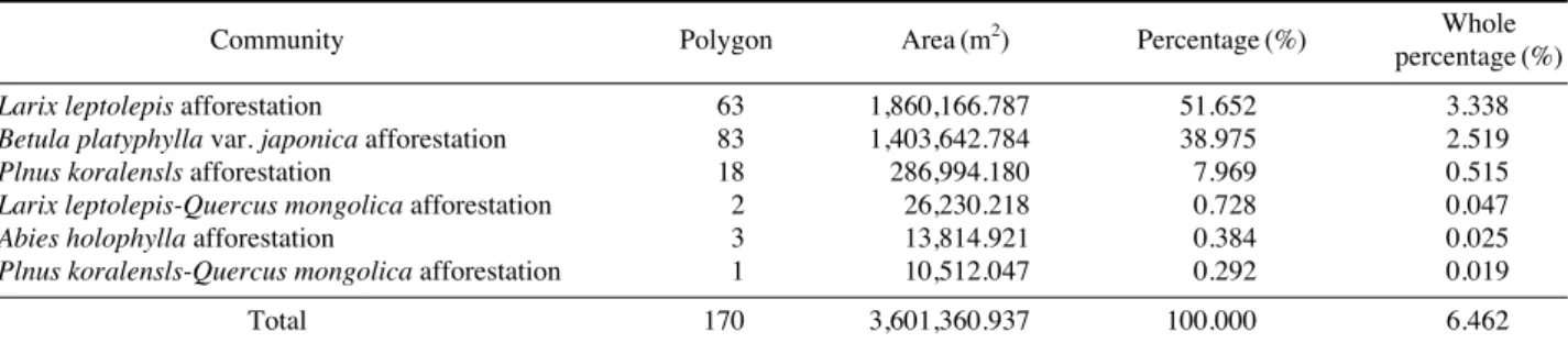
연구대상지역내 조사된 식재림 중 일본잎갈나무가 식 재림 전체의 51.652%로 가장 많이 식재되었으며, 자작 나무가 38.975%, 잣나무가 7.969%로 3개 수종이 전체 의 98.565%로 차지하고 있다(Table 7). 6개 식재군락은
Table 7. Plant communities of afforestation by physiognomy classification of Gyebangsan area in the Odaesan National Park.
Community Polygon Area (m2) Percentage (%) Whole
percentage (%)
Larix leptolepis afforestation 63 1,860,166.787 51.652 3.338
Betula platyphylla var. japonica afforestation 83 1,403,642.784 38.975 2.519
Plnus koralensls afforestation 18 286,994.180 7.969 0.515
Larix leptolepis-Quercus mongolica afforestation 2 26,230.218 0.728 0.047
Abies holophylla afforestation 3 13,814.921 0.384 0.025
Plnus koralensls-Quercus mongolica afforestation 1 10,512.047 0.292 0.019
Total 170 3,601,360.937 100.000 6.462
Table 8. Plant communities of other vegetation by physiognomy classification of Gyebangsan area in the Odaesan National Park.
Community Polygon Area (m2) Percentage (%) Whole
percentage (%)
Agricultural 15 69,482.528 68.232 0.125
Actlnldla arguta Community 1 19,514.330 19.163 0.035
Secondary grass 1 7,246.838 7.116 0.013
Abandoned Land 3 5,589.103 5.489 0.010
Total 20 101,832.799 100.000 0.183
Table 9. Plant communities of nonvegetation by physiognomy classification of Gyebangsan area in the Odaesan National Park.
Community Polygon Area (m2) Percentage (%) Whole
percentage (%)
Development area 1 2,510.116 80.769 0.005
Bare ground 1 597.642 19.231 0.001
Total 2 3,107.758 100.000 0.006
오대산 국립공원 일대에서 자생군락을 형성하고 있는 신갈나무와 혼생하고 있어 향후 천이가 진행되면 자연 군락으로 빠르게 군락 대체가 예상된다.
기타 식생으로는 휴경지, 다래군락, 2차 초지, 농경지 등으로 약 101,832.799 m2로서 오대산 국립공원 전체 식 생면적의 0.183%를 차지하고 있다(Table 8).
결론적으로 오대산 국립공원 계방산 일대의 산림식생 은 신갈나무가 최상층부의 우점종으로 구성되어 있으며, 이들 종들과 관련된 수많은 군락들은 식생천이 및 기후 적 요인들에 의하여 군락 대체가 매우 빠르게 일어날 것 으로 보인다. 따라서 주요 종들의 천이에 의한 군락 대 체가 이뤄질 경우 계방산 일대는 산지낙엽활엽수림 중 고도가 높은 지역에서는 신갈나무군락, 산지습성림은 들 메나무, 층층나무가 우점하는 식생유형을 나타낼 것이다.
적 요
오대산 국립공원 계방산(해발고도 1,577 m) 일대의 산 지삼림식생은 산지낙엽활엽수림, 산지습성림, 산지침엽수 림, 아고산침엽수림, 아고산활엽수림, 식재림으로 세분되 었으며, 기타식생으로 다래군락, 농경지 등이 조사되었다.
상관대분류에 의하여 구분된 각각의 산지삼림식생을 구성하고 있는 분포군락수는 산지낙엽활엽수림은 33개 군락, 산지습성림 41개 군락, 산지침엽수림 8개 군락, 아 고산침엽수림 4개 군락, 아고산활엽수림 2개 군락, 식재 림 6개 군락, 기타식생 4개 군락이 조사되었다.
조사된 주요 군락의 분포 비율을 보면 산지낙엽활엽 수림은 신갈나무군락이 30,909,942.967 m2의 80.220%
로 가장 높은 분포 비율로 조사되었고, 굴참나무군락이 1,067,479.335 m2의 2.770%를 차지하고 있으며, 계방산 일대 산지낙엽활엽수림의 65.755%는 신갈나무가 우점 또는 차우점종으로 분포하고 있다. 산지습성림은 물푸레 나무- 가래나무군락이 전체의 10.955%를 차지하고 있으 며, 물푸레나무와 상층부의 식피율이 비슷하여 혼생군락 을 이루고 있는 군락은 10개 군락으로 전체의 32.776%
를 차지하고 있다. 산지침엽수림은 소나무와 이와 혼생 하는 군락이 전체의 100%로서 산지침염수림은 소나무 가 상층부에서 우점종으로 나타나는 군락의 양상을 나타 내고 있다. 기타식생에서 아고산침엽수림은 전나무- 신갈 나무군락 등 총 4개 군락이 조사되었으며 오대산 국립 공원 전체 식생면적의 4.980%를 차지하고 있다. 아고산 활엽수립은 사스래나무- 층층나무군락 등 총 2개 군락이 조사되었으며 오대산 국립공원 전체 식생면적의 0.006%
를 차지하고 있다. 식재림은 일본잎갈나무가 식재림 전 체의 51.652%로 가장 많이 식재되었으며, 자작나무가 38.975%, 잣나무가 7.969%로 3개 수종이 전체의 98.565
%로 대부분이 이들 3종에 의하여 식재되어졌다.
결론적으로 오대산 국립공원 계방산 일대의 산림식생 은 신갈나무가 최상층부의 우점종으로 구성되어 있으며, 이들 종들과 관련된 수많은 군락들은 식생천이 및 기후 적 요인들에 의하여 군락 대체가 매우 빠르게 일어날 것으로 보인다. 따라서 이 지역 일대 잠재 자연 식생의 주요종은 산지낙엽활엽수림은 신갈나무, 산지습성림은 가래나무, 들메나무, 산지낙엽활엽수림은 신갈나무, 산지 습성림은 물푸레나무, 가래나무, 들메나무, 산지낙엽활엽 수림과 산지습성림의 경계부 중 습도가 높은 계곡부는 층층나무, 들메나무, 사면부는 신갈나무로 대체가 빠르 게 일어날 것으로 보인다. 그러나 아고산의 침염수림은 기후온난화, 인위적 교란 등에 의하여 점차적으로 낙엽 활엽수의 분포비율이 증가할 것으로 보인다.
사 사
본 연구 논문은 국립공원관리공단 국립공원 정밀식생 도 제작사업(오대산 국립공원, 2013)의 일부 결과를 반 영하여 작성되었습니다.
REFERENCES
Braun-Blanquet, J. 1964. Pflanzensoziologie. Grundzuge der Vegetationstunde, Wien, pp. 865.
Choi, S., W.K. Lee., Y. Son, S. Yoo and J.H. Lim. 2010. Changes in the distribution of South Korean forest vegetation sim- ulated using thermal gradient indices. Science China 53(7):
784-797
Hongcheon County. 2008. http://www.hongcheon.go.kr/.
Hwang, H.S., J.C. Yang, Y.M. Lee, S.H. Oh, S.J. Ji, S.Y. Jeong and H.J. Lee. 2013. Floristic Study of Mt. Gyebang Pyeong- chang-gun, Gangwon-do in Korea. The Korea Institute of Forest Recreation Welfare. 2013(4): 438-441.
Kim, J.H., Y.H. Kim and C.Y. Yoon. 2010. Vascular plants of the Hongcheon-gun area in Gangwon province. Korean Journal of Environment and Ecology 24(4): 363-394.
Korea National Park Service. 2013. The actual vegetation map in the Odaesan National park. 125p.
Lee, C.B. 1971. The Vegetation of Odaesan and Sogeumgang.
Korea Nature Conservation Research. Preliminary Research Report on sogeunmgang and Odaesan. pp. 99-115.
Lee, K.J., W. Cho., B.H. Han. 1996. Plant community structure of Pinus densiflora forests in Odaesan National Park.
Korean Journal of Environment and Ecology 9(2): 115- 125.
Lee, S. 2000a. A study on characteristic of forest vegetation and site in Mt. Odae (I) - Site of plant community in Tondgae- san -. Journal of Korean Forest Society 89: 173-184.
Lee, S. 2000b. A study on characteristic of forest vegetation and site in Mt. Odae (II) - Site of plant community in Tondgae- san -. Journal of Korean Forest Society 89: 552-563.
Lee, U.C., Y.S. Kim, Y.B. Lee and Y.G. Park. 1998. The flora of the north-western slope on Odaesan National Park.
Korea Nature Conservation Research Report 38: 13-45.
Lim, J.H. 2009. Moving species due to climate change and bio- diversity change. Korea forest research institute.
Ministry of Environment∙National Institute of Environmental
Research. 2006. 3rd National natural environment research guidelines. Ministry of Environment∙National Institute of Environmental Research.
Ministry of Environment. 2009. Survey methods and classifica- tion criteria of National Environment.
Ministry of Environment∙National Institute of Environmental Research. 2012. Workshop source book of detail actual vegetation mapping in 2012.
Prak, B.K. and J.Y. Oh. 1971. The Vegetation of Odaesan. Korea Nature Conservation Research. Preliminary Research Re- port on sogeunmgang and Odaesan. pp. 131-138.
Yun, C.W., S.H. Lee, H.J. Kim, H.S. Sin, H.G. Park, M.S. Yu and C.H. Lee. 2010. Classification of Forest. Vegetation and Physiognomy Type in Mt. Odea. Korean Forest Society.
pp. 174-177.