http://dx.doi.org/10.11614/KSL.2013.46.3.449 ISSN: 2288-1115 (Print), 2288-1123 (Online)
─
─ 449 ──
덕유산 국립공원 거칠봉 일대 삼림식생의 군락분포에 관한 연구
오장근∙김창환1,*∙이남숙2∙진유리 (국립공원관리공단, 1전북대학교 생태조경디자인학과,
2전북대학교 대학원 생태조경디자인학과)
Community Distribution on Forest Vegetation of the Geochilbong Area in the Deogyusan National Park, Korea. Oh, Jang-Geun, Chang-Hwan Kim1,*, Nam-Sook Lee2 and Yu-Ri Gin (Korea National Park Service, Gondeok-dong, Mapo-gu, Seoul 121-717, Korea; 1Department of Ecology Landscape Architecture-Design, Chonbuk National University; 2Department of Ecology Landscape Architecture-Design, Graduate School of Chonbuk National University)
Forest vegetation of Geochilbong (1,177 m) in Deogyusan National Park is classified into mountain forest vegetation and flatland forest vegetation. Mountain forest vegetation is subdivided into deciduous broad-leaved forest, valley forest, coniferous forest, afforestation and etc., while riparian forest was found under the category of flatland forest vegetation. Including 89 communities of mountain forest vegetation and 4 communities of other vegetation, the total of 93 communities were researched;
the distributed colonies classified by physiognomy classification are 32 communities deciduous broadleaved forest, 21 communities of valley forest, 12 communities of coniferous forests, 24 afforestation and 4 other communities. As for the distribution rate for surveyed main communities, Quercus mongolica, Quercus serrata, Quercus variabilis communities account for 56.54 percent of deciduous broad-leaved forest, Fraxinus mandshurica, Cornus controversa community takes up 46.58 percent of mountain valley forest, Pinus densiflora community holds 74.98 percent of mountain coniferous forest holds. In conclusion, minority species consisting of Quercus mongoli- ca, Quercus serrata, Quercus variabilis, Fraxinus mandshurica, Cornus controversa, Pinus densiflora are distributed as dominant species of the uppermost part in a forest vegetation of Geochilbong in Deogyusan National Park. In addition, because of vegetation succession and climate factors, numerous colonies formed by the two species are expected to be replaced by Quercus mongolica, Carpinus laxiflora and Fraxinus mandshurica which are climax species in the area. However, the distri- bution rate of deciduous broad-leaved forest seems to increase gradually due to global warming and artificial disturbance.
Key words : forest vegetation, Fraxinus mandshurica, Geochilbong, physiognomy classification, Quercus mongolica
* Corresponding author: Tel: +82-63-850-0736, Fax: +82-63-850-0735, E-mail: [email protected]
ⓒ The Korean Society of Limnology. All rights reserved.
This is an open-access article distributed under the terms of the Creative Commons Attribution Non-Commercial License (http://creativecommons.org/licenses/by-nc/3.0/), which permits unrestricted non-commercial use, distribution, and reproduction in any medium, provide the original work is properly cited.
서 론
소백산맥의 중심부에 위치한 덕유산 국립공원은 내륙 산악지형으로서 한반도 중∙남부 대륙산악 식생의 전형 적인 특징을 나타내고 있는 대표적인 지역이다. 덕유산 국립공원은 주봉인 향적봉(1,614 m)을 포함하여 남덕유산 (1,507 m), 무룡산(1,491 m), 삿갓봉(1,410 m), 거칠봉(1,177 m), 두문산(1,161 m), 시루봉(1,105 m), 적상산(1,029 m) 등 1,000 m 이상의 높은 봉우리들이 산재해 있어 계곡이 깊고 지형∙지질적 특징이 다양하여 수많은 동∙식물들 의 서식처를 만들어 내고 있는 생태계의 보고이다.
이 지역의 30년간(1971~2000년) 기상 자료를 종합하 면 평균 기온은 11.5�C이며, 8월은 24�C, 5월은 16.5�C, 10월은 12.4�C, 가장 추운 달인 1월은 -1.8�C이다. 연강 수량은1,265.9 mm, 계절적으로는 연강수량의50~60%가 7~8월에 집중되어 있다(Korea National Park Service, 2004).
특히 본 조사 지역인 거칠봉 지역과 향적봉 지역의 경 계가 되는 구천동 계곡지역의 북반부를 형성하는 석영안 삼암으로 인하여 거칠봉의 수려한 지형 경관이 연출될 뿐 만 아니라 여러곳에서 절각 돌출된 암체는 구천동 계곡의 절경과 다양한 식물군락을 만들고 있다(Korea National Park Service, 2004).
거칠봉(1,177 m) 지역의 식생은 산지낙엽활엽수림대가
발달하여 계곡 등 일부 지역을 제외하고는 신갈나무에 의 하여 우점되어 있고 사면 저지대 및 계곡에는 서나무, 졸 참나무, 들메나무 등이 주로 분포한다. 거칠봉을 포함한 덕유산 국립공원은 남부아구의 식물구계와 냉온대 중∙
남부의 식물군계의 특징을 보이고 있어 한반도 중부지역 의 전형적인 식물군락의 분포와 종조성적 특징을 나타내 고 있다(Yim and Kira, 1976; Lee and Yim, 1978).
덕유산과 관련된 조사 및 연구는 최근까지 Kim (1992), Korea National Park Service (2004), Park et al. (1994), Kim and Kil (1997), Moon (2001), Kim et al. (2009a), Kim et al. (2009b), Kim et al. (2010), Kim et al. (2013) 등 에 의하여 지속적으로 이뤄져 왔으며, 지리산, 설악산, 오 대산 등과 같이 많은 연구가 수행되어졌다. 그러나 본 연 구 지역인 거칠봉 지역에 범위를 한정하여 조사된 연구 는 거의 이뤄지지 않아 덕유산 국립공원의 식물상 및 식 생과 관련된 지역적 특징뿐만 아니라 지질∙지형적 특징 등이 반영된 관리가 어려운 실정이다.
따라서 본 연구는 국립공원관리공단에서 진행하고 있 는 1 : 5,000 축척의 생태자연도 정밀화 사업의 일환으로
국립공원 자원모니터링 기본조사 자료의 활용성을 높이 고 국립공원 의사결정 도구로써 신뢰성을 높이기 위한 고축척 식생 전자지도의 필요성에 의하여 추진된 결과의 일부이다. 정밀식생도 제작은 국립공원 경계 1 : 5,000 정 밀임상도, 특별보호구역지도, 수치지도, 항공영상의 원시 자료를 연구 목적에 맞게 가공 변환하여 사용하였다. 따 라서 기존 식생연구 및 식생도 제작에서 주로 사용한 1 :
25,000의 지형도를 이용한 조사에 비해 보다 정밀한 조
사가 수행된 결과 중 상관대분류로 세분한 식물군락에 대한 현존식생도 및 식물군락 분포 현황에 따른 식생의 특징을 분석한 것이다.
또한 덕유산 국립공원을4개 지역으로 구분하여 비교∙
분석함으로써 향후 덕유산 국립공원의 보전∙복원∙관리
∙이용방안에 대한 구체적인 자료를 제공하는 데 있다.
재료 및 방법
1. 조사범위
본 연구의 조사범위는 덕유산 국립공원의 현존식생을 보다 정밀하게 분석하기 위하여 향적봉 일대, 남덕유산 일대, 적상산 일대, 거칠봉 일대의 4개 주봉을 중심으로 하여 세분하였다. 본 연구에서는 세분된4개 지역 중 거
Fig. 1. Location of Geochilbong area in Deogyusan Natio- nal Park.
Geochilbong
National Park Office Jeoksangsan
Hyangjeokbong Jungbong
Anseong district Songgyesa district
Muryoungsan
Namdeogyusan 0 2 4 6 8km
N
칠봉 일대를 연구지역으로 설정한 후 현존식생도와 군락 의 분포현황을 분석하였다(Fig. 1).
2. 식생조사도면 제작
1)
식생조사도면영상자료 및 수치지형도 등 참조자료를 활용하여 삼림 과 비삼림지역, 삼림 내 활엽수림, 침엽수림, 혼효림 등 대분류 수준의 식생 상관분류를 실시하였다. 이를 정밀식 생조사 시 참고할 수 있도록 식생조사도면을 작성∙출력 하였으며, 국립공원 경계1 : 5,000 정밀임상도, 특별보호구 역, 수치지도, 항공영상의 원시자료를 목적에 맞게 가공
∙변환하여 중첩하여 제작하였다. 좌표계는 GRS80 중부 원점으로 통일하여 작성하였다.
2)
작성기준 및 분류체계본 연구에서 식생조사도면 작성기준은 환경부∙국립환 경과학원 정밀현존식생도 제작사업 수행 시 적용한 작성 기준에 따라 식생조사도면을 작성하였으며(Ministry of Environment∙National Institute of Environmental Research, 2006) 식생조사도면 작성 시에는 영상 및 수치 지도를 활용하여 분류 가능한 범위 내에서 활엽수림, 침 엽수림, 혼효림, 암벽식생, 기타식생의 5가지 내용으로 분 류하였다.
3. 현존식생도 제작
1)
위치보정 및 자료변환입수한 참조자료 중Bessel 타원체 기준 좌표체계로 되 어 있는 데이터는 세계측지계로 좌표변환을 실시하여 활 용하였고, 영상자료는 국토지리정보원에서 제공받은 정 사편위 완료 영상으로 위치보정 없이 사용하였다. 또한 참조자료를 활용한 식생 외곽경계 및 내부경계를 분류한 후 기 작성된 내장산 국립공원 정밀식생도GIS-DB 속성 을 참고로 하여 식생속성을 입력하였다.
2)
현장식생조사용 도면식생대분류 결과와 항공사진, 수치지형도 및 참조자료 를 이용하여 식생조사도면 출력용 이미지 파일작성을 실 시하였다. 도면은 식생조사도면, 참고도면, GPS 도면 등으 로 구분하여 작성하였다.
4. 식생조사
2012년3월부터2013년1월까지 현장식생조사용 도면 (1 : 5,000) 및 항공영상자료를 참고하여 덕유산 국립공원
지역을 Braun-Blauquet (1964)의 식물사회학적 조사방 법과 환경부의 제3차 전국자연환경조사의 식생조사 지침 을 참고하여 조사하였다(Ministry of Environment, 2009).
식물의 분류와 동정은Lee (1996)을 참조하였다.
결과 및 고찰
1. 상관대분류에 따른 군락 분포
덕유산 국립공원내 거칠봉(1,777 m)은 무주구천동 계 곡을 경계로 하여 북쪽에 위치하며, 남쪽에는 덕유산의 주봉인 향적봉(1,614 m)과 남덕유산(1,507 m)이 있다.
거칠봉 일대의 삼림식생은 입지의 지형적 특성에 따라 산지삼림식생과 평지삼림식생으로 대별되었다(Kim et al., 2013).
산지삼림식생은 산지낙엽활엽수림, 산지습성림, 산지침 엽수림, 아고산침엽수림, 식재림으로 세분되었으며, 기타 식생으로 칡군락, 농경지 등이 있다. 이들 중 산지 삼림식 생을 구성하고 있는 각각의 분포군락수는 산지낙엽활엽 수림32개 군락, 산지습성림21개 군락, 산지침엽수림12 개 군락, 식재림 24개 군락이 분포하여 총 89개의 군락 이 조사되었으며, 기타식생4개 군락이 조사되어 전체93 개 군락이 분포한다(Fig. 2).
거칠봉 일대 산지 삼림식생89개 군락 중 분포면적1%
이상은20개 군락으로 전체 군락의 약 91.67%를 차지하 고 있으며, 군락분포 면적 1% 이하 군락은 전체 면적 8.33%, 72개 군락으로 조사되었다(Tables 2, 3, 4, 5, 6).
Table 1의 상관대분류별로 볼 때 산지낙엽활엽수림은 분
포면적 1% 이상 군락이 10개로 조사되었으며, 신갈나무 군락, 신갈나무-굴참나무군락, 굴참나무군락 순으로 분포 비율이 높았다.
산지습성림은 들메나무군락, 층층나무군락, 층층남-들메 나무군락 등의4개 군락이1% 이상 분포 면적을 차지하 고 있어 거칠봉 일대 산지 계곡은 대부분이 들메나무와 층층나무에 의하여 강하게 우점되어 있음을 알 수 있다. 산지침엽수림은 소나무군락이 7.943%로 소나무-신갈나 무군락, 소나무-굴참나무군락의 1.184%, 1.164%보다 분 포 면적 비율이 높아 거칠봉 일대 침엽수림은 대부분이 소나무군락이 분포하고 있음을 알 수 있다. 그러나 소나 무군락을 제외한 소나무-신갈나무군락과 소나무-굴참나 무군락의 침엽수림대 혼효림은 천이가 진행되면 신갈나 무군락으로 군락 대체가 예상되어 거칠봉 일대 침엽수림 의 분포 면적은 감소할 것으로 보인다(Kim, 1992; Choi
Fig. 2. Actual vegetation map in the Geochilbong of Degyusan National Park from Mar. 2012 to Jan. 2013.
0 550 1100 2200
m
N
S
W E
et al., 2013).
한편 거칠봉 일대의 식재림은 거칠봉 사면 저지대의 마을, 경작지, 도로와 연접된 부분에 일본잎갈나무, 리기 다소나무 등이 비교적 넓은 면적으로 식재림이 조성되어 있어 천이의 진행과 함께 참나무속 수종으로 매우 빠르 게 군락이 대체될 것으로 보인다.
결론적으로 거칠봉 일대의 산림식생은 신갈나무, 굴참 나무, 소나무, 들메나무, 층층나무 등 이들 종들과 혼생군 락을 이루고 있는 군락들은 천이 및 기후적 요인들에 의
하여 산지낙엽활엽수림은 신갈나무, 산지습성림은 들메 나무와 층층나무 군락으로 대체가 빠르게 일어날 것으로 보인다(Choi et al., 2013).
2. 산지삼림식생
1)
산지낙엽활엽수림거칠봉 일대 산지낙엽활엽수림은 능선부, 산지사면 상 부와 중부에 집중적으로 분포하고 있으며, 정상 부근 경
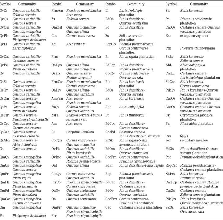
Symbol Community Symbol Community Symbol Community Symbol Community
QvZs Quercus variabilis- FrmAm Fraxinus mandshurica- Ll Larix leptolepis Sk Salix koreensis
Zelkova serrata Acer mono plantation
QvQs Quercus variabilis- Zs Zelkova serrata PdQa Pinus densiflora- Po Platanus occidentalis
Quercus serrata Quercus acutissima plantation
QvQm Quercus variabilis- QmQal Quercus mongolica- Pd Pinus densiflora CacQv Castanea crenata-Quercus
Quercus mongolica Quercus aliena variabilis plantation
QvPls Quercus variabilis- Coc Cornus controversa Zs Zelkova serrata Esa except survey area
Platycarya strobilacea plantation
QvLl Quercus variabilis- Ag Acer ginnala RopCoc Robinia pseudoaccacia-
Larix leptolepis Cornus controversa Pth Pueraria thunbergiana
plantation
QvCac Quercus variabilis- Frm Fraxinus mandshurica Pr Pinus rigida plantation SkZs Salix koreensis-
Castanea crenata Zelkova serrata
QvPd Quercus variabilis- QalQm Quercus aliena- PdRop Pinus densiflora- Abh Abies holophylla
Pinus densiflora Quercus mongolica Robinia pseudoaccacia plantation
Qv Quercus variabilis QsPrs Quercus serrata- CocQs Cornus controversa- CacLl Castanea crenata-
Prunus sargentii Quercus serrata Larix leptolepis plantation
QsZs Quercus serrata- FrmCoc Fraxinus mandshurica- Pik Pinus koraiensis SkCoc Salix koreensis-
Zelkova serrata Cornus controversa plantation Cornus controversa
QsQv Quercus serrata- QalQv Quercus aliena- PdQs Pinus densiflora- PikQv Pinus koraiensis-Quercus
Quercus variabilis Quercus variabilis Quercus serrata variabilis plantation
QsQm Quercus serrata- AmFrm Acer mono- Pk Pinus koraiensis CacQv Castanea crenata-Quercus
Quercus mongolica Fraxinus mandshurica variabilis plantation
QsPd Quercus serrata- ZsQv Zelkova serrata- Abh Abies holophylla CacQv Castanea crenata-Quercus
Pinus densiflora Quercus variabilis variabilis plantation
QsFrr Quercus serrata- ZsPs Zelkova serrata-Prunus Pt Pinus thunbergii Crj Cryptomeria japonica
Fraxinus rhynchophylla serrulata var. plantation
QsCoc Quercus serrata- Am Acer mono PdCoc Pinus densiflora- Pa Picea abies plantation
Cornus controversa Cornus controversa
QsCac Quercus serrata- Cl Carpinus laxiflora CacPd Castanea crenata-
Castanea crenata Pinus densiflora plantation Cva 농경지
QsAbh Quercus serrata- CocQm Cornus controversa- PrSk Pinus rigida-Salix seg secondary meadow Abies holophylla Quercus mongolica koreensis plantation
Qs Quercus serrata QvPk Quercus variabilis- PdQm Pinus densiflora- PdQs Pinus densiflora-Quercus
Pinus koraiensis Quercus mongolica serrata plantation
QmQv Quercus mongolica- QvRop Quercus variabilis- CocFrr Cornus controversa- Pod Populus deltoides plantation Quercus variabilis Robinia pseudoaccacia Fraxinus rhynchophylla
QmQs Quercus mongolica- Qal Quercus aliena PdPr Pinus densiflora-Pinus rigida RopCac Robinia pseudoaccacia-
Quercus serrata Castanea crenata plantation
QmPr Quercus mongolica- CocQv Cornus controversa- Rop Robinia pseudoaccacia SkPrs Salix koreensis-
Pinus rigida Quercus variabilis plantation Prunus sargentii
QmPk Quercus mongolica- FrrCoc Fraxinus rhynchophylla- PdCac Pinus densiflora- CacRop Castanea crenata-Robinia
Pinus koraiensis Cornus controversa Castanea crenata pseudoaccacia plantation
QmPd Quercus mongolica- QaQv Quercus acutissima- PdQv Pinus densiflora- CacZs Castanea crenata-
Pinus densiflora Quercus variabilis Quercus variabilis Zelkova serrata plantation
QmCoc Quercus mongolica- Qa Quercus acutissima CocFrm Cornus controversa- PikQm Pinus koraiensis-
Cornus controversa Fraxinus mandshurica Qercus mongolica plantation
Qm Quercus mongolica QmFrr Quercus mongolica- Cac Castanea crenata plantation SkQs Salix koreensis-
Fraxinus rhynchophylla Quercus serrata
Pls Platycarya strobilacea Frr Fraxinus rhynchophylla
Fig. 2. Continued.
사가 완만하고 비교적 토양습도가 높은 지역에는 물푸레 나무 혼생림이 군락을 이루고 있다. 조사된 산지낙엽활엽 수림 32개 군락(Table 2)의 대부분은 신갈나무, 굴참나무, 졸참나무와 혼생림을 이루고 있다. 32개 군락 중 1개 종 이 최상층에 우점하는 군락은 신갈나무군락이 210개 polygon, 41.01%로 가장 분포역 및 분포비율이 높았으며, 굴참나무군락이 143개 polygon, 9.08%, 졸참나무군락이 59개 polygon, 6.45%이며, 굴피나무군락과 상수리나무군 락이0.10%와0.00% 비율로 분포하고 있다(Table 2).
2종이 최상층에서 혼생하고 있어 혼생군락을 형성하고 있는 군락 중 1% 이상의 분포 비율을 나타내고 있는 군 락은 신갈나무-굴참나무군락이 6,204,212.24 m2, 17.54%, 굴참나무-신갈나무군락이 2,503,969.26 m2, 7.08%, 신갈 나무-층층나무군락이 1,309,419.87 m2, 3.70%, 신갈나무- 소나무군락이1,025,470.15 m2, 2.90%, 신갈나무-졸참나무 군락이 771,426.03 m2, 2.18% 등으로 조사되었다. 또한 전 체32개 군락 중 신갈나무와 혼생하는 군락은10개 군락
34.91%이며, 굴참나무와 혼생하는 군락은 12개 군락, 30.57%, 졸참나무와 혼생하는 군락은 11개 군락, 9.44%
로 나타났다.
이러한 결과는 덕유산 산지낙엽활엽수림의 극상종인 신갈나무(Kim, 1992)와 혼생림을 구성하는 비율이 거칠 봉 일대의34.91%는 향적봉 일대의42.09%에 비해 낮은 반면에 굴참나무와 혼생림을 구성하는 비율은 향적봉 일 대가 14.98%, 거칠봉 일대는 30.57%로 더 높은 분포 비 율을 보였다(Choi et al., 2013).
2)
산지습성림거칠봉 일대 산지습성림은 정상 부근 계곡부의 산지습 성림과 고도가 낮은 지역의 계곡부의 산지습성림으로 구 분된다. 거칠봉 위쪽 계곡부에 주로 분포하고 있는 군락은 들메나무와 층층나무를 우점종으로 하는 군락이 형성되어 있고 아래쪽에는 느티나무, 물푸레나무가 주로 나타난다. 산지습성림의 분포 면적은 전체 조사면적49,657,027.05 m2
Table 1. Communities of ¤1% distribution area in the 94 communities of Geochilbong area in the Deogyusan National Park.
Physiognomy Area Percentage Whole
classification Community Polygon
(m
2) (%) percentage (%)
Quercus mongolica community 210 14,506,698.40 41.01 29.141
Quercus mongolica-Quercus variabilis community 132 6,204,212.24 17.54 12.463
Quercus variabilis community 143 3,212,815.95 9.08 6.454
Quercus variabilis-Quercus mongolica community 57 2,503,969.26 7.08 5.030 Deciduous
Quercus serrata community 59 2,280,970.50 6.45 4.582
broad-leaved
Quercus mongolica-Cornus controversa community 27 1,309,419.87 3.70 2.630 forest
Quercus variabilis-Pinus densiflora community 112 1,025,470.15 2.90 2.060 Quercus variabilis-Quercus serrata community 35 771,426.03 2.18 1.550 Quercus serrata-Quercus variabilis community 31 742,589.96 2.10 1.492 Quercus variabilis-Pinus densiflora community 66 694,215.93 1.96 1.395
Total 806 32,557,574.36 92.04 66.797
Fraxinus mandshurica community 15 805,289.46 24.69 1.618
Mountain Cornus controversa community 40 714,052.82 21.89 1.434
valley forest Cornus controversa-Fraxinus mandshurica community 23 629,341.53 19.30 1.264 Fraxinus mandshurica-Cornus controversa community 17 546,975.71 16.77 1.099
Total 95 2,695,659.52 82.65 5.415
Pinus densiflora community 486 3,954,256.87 75.03 7.943
Coniferous
Pinus densiflora-Quercus variabilis community 65 589,592.80 11.19 1.184 forest
Pinus densiflora-Quercus variabilis community 62 579,692.96 11.00 1.164
Total 613 5,123,542.63 97.22 10.291
Larix leptolepis plantation 343 2,318,834.28 45.36 4.658
Plantation Pinus rigida plantation 93 1,157,454.01 22.64 2.325
Pinus koraiensis plantation 123 1,087,002.37 21.26 2.184
Total 559 4,563,290.66 89.26 9.167
Total 2,073 44,940,067.17 - 91.67
중3,261,575.57 m2로 약6.57%를 차지하고 있다. 조사된 군락은 들메나무군락, 층층나무군락, 느티나무 군락, 고로쇠나무군락, 물푸레나무군락과 이들 군락과의 혼생군락 등 총21개 군락이 분포한다(Table 3).
산지습성림을 형성하고 있는21개 군락의 분포 비율을 보면 들메나무군락과 층층나무군락이 각각 24.69%, 21.89%로 전체의 46.58%를 차지하고 있으며, 층층나무- 들메나무군락의19.30%, 들메나무-층층나무군락의 16.77%
를 포함한 들메나무와 층층나무가 우점종으로서 군락을 형성하고 있는 비율은 전체의 82.65%로서 조사되었다. 따라서 거칠봉 일대의 산지습성림은 덕유산 향적봉 일대 산지습성림군락의 우점종으로서 분포하고 있는 들메나무
군락과 관련된 군락의 분포 비율인 89.36%보다는 낮으 나 거칠봉 일대의 산지습성림 역시 들메나무, 층층나무 등 이 지역 일대의 산지습성림의 구성종들에 의하여 우 점하고 있음을 알 수 있다.
3)
산지침엽수림거칠봉 일대의 산지침엽수림은 정상에서 마을, 경작지, 도로 부근에 집중적으로 군락을 형성하고 있다.
산지침엽수림은 조사지역 전체의 10.62%를 차지하고 있다. 조사된 군락은 12개 군락으로 소나무군락이 산지 침엽수림 중 74.96%를 차지하고 있으며, 소나무-신갈나 무군락, 소나무-굴참나무군락이 각각 11.18%, 10.99%로
Table 2. Plant communities of deciduous broad-leaved forest by physiognomy classification of Geochilbong area in the
Deogyusan National Park.
Area Percentage Whole
Community Polygon
(m
2) (%) percentage
(%)
Quercus mongolica community 210 14,506,698.40 41.01 29.141
Quercus mongolica-Quercus variabilis community 132 6,204,212.24 17.54 12.463
Quercus variabilis community 143 3,212,815.95 9.08 6.454
Quercus variabilis-Quercus mongolica community 57 2,503,969.26 7.08 5.030
Quercus serrata community 59 2,280,970.50 6.45 4.582
Quercus mongolica -Cornus controversa community 27 1,309,419.87 3.70 2.630
Quercus mongolica-Pinus densiflora community 112 1,025,470.15 2.90 2.060
Quercus mongolica-Quercus serrata community 35 771,426.03 2.18 1.550
Quercus serrata-Quercus variabilis community 31 742,589.96 2.10 1.492
Quercus variabilis -Pinus densiflora community 66 694,215.93 1.96 1.395
Quercus serrata-Cornus controversa community 11 492,902.92 1.39 0.990
Quercus serrata-Quercus mongolica community 25 476,597.61 1.35 0.957
Quercus variabilis-Quercus serrata community 39 466,273.30 1.32 0.937
Quercus serrata-Pinus densiflora community 18 157,027.35 0.44 0.315
Quercus serrata-Fraxinus rhynchophylla community 6 143,646.93 0.41 0.289
Quercus variabilis-Zelkova serrata community 9 99,613.16 0.28 0.200
Quercus variabilis-Castanea crenata community 5 54,783.60 0.15 0.110
Quercus serrata-Zelkova serrata community 2 42,035.88 0.12 0.084
Platycarya strobilacea community 1 33,965.83 0.10 0.068
Quercus mongolica-Pinus koraiensis community 4 29,422.87 0.08 0.059
Quercus serrata-Castanea crenata community 3 25,828.37 0.07 0.052
Quercus variabilis-Larix leptolepis community 2 24,426.83 0.07 0.049
Quercus serrata-Abies holophylla community 1 18,101.65 0.05 0.036
Quercus variabilis-Platycarya strobilacea community 1 13,416.94 0.04 0.027
Quercus mongolica-Pinus rigida community 1 13,283.35 0.04 0.027
Quercus mongolica-Fraxinus rhynchophylla community 2 11,006.38 0.03 0.022
Quercus variabilis-Robinia pseudoaccacia community 1 6,219.63 0.02 0.012
Quercus serrata-Prunus sargentii community 1 4,562.84 0.01 0.009
Quercus mongolica-Quercus aliena community 2 4,238.99 0.01 0.009
Quercus variabilis-Pinus koraiensis community 1 2,778.31 0.01 0.006
Quercus acutissima community 1 1,516.74 0.00 0.003
Quercus acutissima-Quercus variabilis community 1 1,392.22 0.00 0.003
Total 1,009 35,374,829.99 100.00 71.060
산지침엽수림의 97.13%로서 대부분이 이들 3개 군락으 로 이뤄져 있다(Table 4).
4)
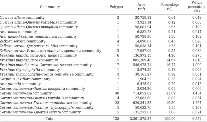
식재림 및 기타식생거칠봉 지역의 식재림은 대부분이 마을, 경작지, 도로와
연접된 지역 등 산의 저지대 및 국립공원 경계선에 대상 으로 분포한다. 조사된 식재림 중 일본잎갈나무가 식재림 전체의 45.36%, 리기다소나무 22.64%, 잣나무 21.26%, 밤나무6.89%로 전체 식재림의96.15%로 차지하고 있어 식재된 대부분의 수종은 이들4종 및4종과 혼생림을 이
Table 3. Plant communities of mountain valley forest by physiognomy classification of Geochilbong area in the Deogyusan.
Area Percentage Whole
Community Polygon
(m
2) (%) percentage
(%)
Quercus aliena community 3 20,759.82 0.64 0.042
Quercus aliena-Quercus variabilis community 1 3,923.14 0.12 0.008
Quercus aliena-Quercus mongolica community 1 96,081.94 2.95 0.193
Acer mono community 1 6,882.28 0.21 0.014
Acer mono-Fraxinus mandshurica community 1 50,788.36 1.56 0.102
Zelkova serrata community 4 14,098.61 0.43 0.028
Zelkova serrata-Quercus variabilis community 2 50,038.14 1.53 0.101
Zelkova serrata-Prunus serrulata var. spontanea community 2 17,987.09 0.55 0.036
Fraxinus mandshurica-Acer mono community 6 136,973.15 4.20 0.275
Fraxinus mandshurica community 15 805,289.46 24.69 1.618
Fraxinus mandshurica-Cornus controversa community 17 546,975.71 16.77 1.099
Fraxinus rhynchophylla community 1 3,874.59 0.12 0.008
Fraxinus rhynchophylla-Cornus controversa community 3 30,165.27 0.92 0.061
Carpinus laxiflora community 2 11,904.32 0.36 0.024
Acer ginnala community 1 6,425.91 0.20 0.013
Cornus controversa-Quercus mongolica community 1 3,034.26 0.09 0.006
Cornus controversa community 40 714,052.82 21.89 1.434
Cornus controversa-Quercus variabilis community 4 27,083.80 0.83 0.054
Cornus controversa-Fraxinus mandshurica community 23 629,341.53 19.30 1.264 Cornus controversa-Fraxinus rhynchophylla community 5 50,622.76 1.55 0.102
Cornus controversa- Quercus serrata community 5 35,272.61 1.08 0.071
Total 138 3,261,575.57 100.00 6.552
Table 4. Plant communities of coniferous forest by physiognomy classification of Geochilbong area in the Deogyusan National Park.
Area Percentage Whole
Community Polygon
(m
2) (%) percentage
(%)
Pinus densiflora community 486 3,954,256.87 74.96 7.943
Pinus densiflora-Quercus mongolica community 65 589,592.80 11.18 1.184
Pinus densiflora-Quercus variabilis community 62 579,692.96 10.99 1.164
Pinus densiflora-Castanea crenata community 7 61,231.71 1.16 0.123
Pinus densiflora-Pinus rigida community 5 25,609.01 0.49 0.051
Pinus densiflora-Quercus serrata community 5 25,413.37 0.48 0.051
Pinus densiflora-Robinia pseudoaccacia community 2 20,541.47 0.39 0.041
Pinus densiflora-Cornus controversa community 1 10,678.54 0.20 0.021
Pinus koraiensis community 2 3,411.81 0.06 0.007
Pinus densiflora-Quercus acutissima community 1 2,304.97 0.04 0.005
Abies holophylla community 1 1,268.93 0.02 0.003
Pinus thunbergii community 1 1,082.23 0.02 0.002
Total 638 5,275,084.67 100.00 10.596
루는 것으로 조사되었다(Table 5). 24개 식재군락 중6개 식재군락은 덕유산 국립공원 일대에서 자생군락을 형성 하고 있는 신갈나무, 졸참나무, 굴참나무, 소나무 등과 혼 생하고 있어 향후 천이가 진행되면 자연군락으로 빠르게 군락 대체가 예상된다.
기타 식생으로는 농경지, 칡군락, 2차 초지, 조사제외지 역 등으로 약 632,963.89 m2로서 전체의 약 1.27%를 차 지하고 있다.
결론적으로 덕유산 국립공원 거칠봉 일대의 산림식생 은 신갈나무, 졸참나무, 굴참나무, 들메나무, 층층나무, 소 나무 등 지형적, 고도, 습도 등의 주요 요인들에 의하여 최상층부가 우점되어 있으며, 이들 종들과 혼생하는 수많 은 군락들은 식생천이 및 다양한 환경요인에 의하여 극 상림으로 군락 대체가 일어날 것으로 보인다. 따라서 주 요종들의 천이에 의한 군락대체가 이뤄질 경우 적상산 일대는 산지낙엽활엽수림 중 고도가 높은 지역에서는 신
Table 5. Plant communities of afforestation by physiognomy classification of Geochilbong area in the Deogyusan National
Park.
Area Percentage Whole
Community Polygon
(m
2) (%) percentage
(%)
Larix leptolepis afforestation 343 2,318,834.28 45.36 4.66
Pinus rigida afforestation 93 1,157,454.01 22.64 2.33
Pinus koraiensis afforestation 123 1,087,002.37 21.26 2.18
Castanea crenata afforestation 54 352,419.62 6.89 0.71
Robinia pseudoaccacia afforestation 9 52,428.67 1.03 0.11
Castanea crenata-Pinus densiflora afforestation 5 17,546.30 0.34 0.04
Robinia pseudoaccacia-Cornus controversa afforestation 1 14,958.62 0.29 0.03
Pinus rigida-Salix koreensis afforestation 1 12,838.92 0.25 0.03
Zelkova serrata afforestation 3 11,809.83 0.23 0.02
Pinus koraiensis-uercus mongolica afforestation 1 10,463.91 0.20 0.02
Populus deltoides afforestation 3 10,274.17 0.20 0.02
Castanea crenata-Larix leptolepis afforestation 1 10,208.68 0.20 0.02
Castanea crenata-Quercus variabilis afforestation 3 9,294.99 0.18 0.02
Pinus koraiensis-Quercus serrata afforestation 1 6,894.22 0.13 0.01
Castanea crenata-Zelkova serrata afforestation 1 6,350.70 0.12 0.01
Castanea crenata-Robinia pseudoaccacia afforestation 2 5,651.18 0.11 0.01
Robinia pseudoaccacia-Castanea crenata afforestation 1 5,631.96 0.11 0.01
Pinus koraiensis-Quercus variabilis afforestation 3 5,458.70 0.11 0.01
Abies holophylla afforestation 3 5,378.55 0.11 0.01
Picea abies afforestation 1 4,648.96 0.09 0.01
Chamaecyparis obtusa afforestation 1 2,454.37 0.05 0.00
Platanus occidentalis afforestation 1 2,317.27 0.05 0.00
Castanea crenata-Quercus variabilis afforestation 1 1,331.70 0.03 0.00
Cryptomeria japonica afforestation 1 920.97 0.02 0.00
Total 656 5,112,572.93 100.00 10.27
Table 6. Plant communities of other vegetation by physiognomy classification of Geochilbong area in the Deogyusan National Park.
Area Percentage Whole
Community Polygon
(m
2) (%) percentage
(%)
Agricultural 50 319,961.56 50.55 0.643
Pueraria thunbergiana community 64 168,123.27 26.56 0.338
secondary meadow 22 73,815.67 11.66 0.148
except survey area 12 71,063.39 11.23 0.143
Total 148 632,963.89 100.00 1.271
갈나무군락, 산의 저지대 및 사면 하부에서는 서나무, 개 서나무, 산지습성림은 들메나무, 층층나무가 우점하는 식 생유형을 나타낼 것이다.
적 요
덕유산 국립공원 거칠봉(해발고도 1,177 m) 일대 삼림 식생은 산지삼림식생과 평지삼림식생으로 대별되어있다. 산지삼림식생은 산지낙엽활엽수림, 산지습성림, 산지침엽 수림, 아고산침엽수림, 식재림 등으로 세분되었으며, 평지 삼림식생은 하반림이 조사되었다.
상관대분류에 의하여 구분된 산지삼림식생의 분포군락 수는 산지낙엽활엽수림 32개 군락, 산지습성림 21개 군 락, 산지침엽수림12개 군락, 식재림24개 군락, 기타 3개 군락의 총 93개 군락이 조사되었다. 조사된 주요 군락의 분포 비율을 보면 산지낙엽활엽수림은 신갈나무군락이 14,506,698.40 m2의29.14%로 가장 높은 분포 비율로 조 사되었고, 굴참나무군락이 3,212,815.95 m2의 6.45%, 졸 참나무군락 2,280,970.50 m24.58%로 3개 군락이 전체의 40.17%를 차지하고 있었으며, 산지습성림은 들메나무군 락과 층층나무군락이 전체의 1.62%, 1.43%로 거칠봉 일 대의 산지습성림은 들메나무와 층층나무군락이 전체의 3.05%로 대부분을 차지하고 있는 것으로 조사되었다. 산 지침엽수림은 소나무군락이 전체의 7.94%로서 대부분의 산지침염수림은 소나무1종이 상층부에서 우점종으로 나 타나는 군락의 양상을 나타내고 있다. 식재림은 일본잎갈 나무가 식재림 전체의4.66%로 가장 많이 식재되었으며, 리기다소나무가2.33%, 잣나무가2.18%로 3개 수종이 전 체의9.17%로 대부분이 이들3종에 의하여 식재되어졌다. 결론적으로 덕유산 국립공원 거칠봉 일대 삼림식생은 신갈나무, 졸참나무, 굴참나무, 들메나무, 층층나무, 소나무 등 소수의 수종이 최상층부의 우점종으로 분포하고 있으 며 2종에 의하여 형성된 수많은 군락들은 식생천이 및 기후적 요인에 의하여 이 지역 일대의 극상수종인 신갈 나무, 서나무, 들메나무 등으로 군락 대체가 예상된다. 그 러나 아고산침엽수림은 기후온난화와 인위적 교란에 의 하여 점차적으로 낙엽활엽수의 분포비율이 증가할 것으 로 보인다.
사 사
본 연구 논문은 국립공원관리공단 국립공원 정밀식생
도 제작사업(덕유산 국립공원, 2012)의 일부 결과를 반영 하여 작성되었습니다.
인 용 문 헌