ORIGINAL ARTICLE
Effects on Vegetation Distribution of Odaesan National Park according to Climate and Topography of Baekdudaegan, Korea
Bong-Ho Han, Jin-Woo Choi
1), Jung-Hun Yeum
2)*Department of Landscape Architecture, University of Seoul, Seoul 02504, Korea
1)Environmental Ecosystem Research Foundation, Seoul 05643, Korea
2)National Wetlands Center, National Institute of Environmental Research, Changnyeong 50303, Korea
Abstract
This study aimed to understand the distribution of vegetation in the eastern and western sides of the Baekdudaegan (ridge) dividing the Odaesan National Park, as influenced by its topography and climate. The actual vegetation, topography and climate for each side were used in the overlay analysis. The results of the analysis of actual vegetation showed a high distribution rate of Quercus mongolica forest on both the eastern and western sides.
On the eastern side, the distribution rate of Pinus densiflora forest and P. densiflora-Q. variabilis forest was high, while the western side had a high distribution rate of deciduous broad-leaved tree forest and Abies hollophylla forest. A clear trend was identified for vegetation distribution with respect to elevation but not with respect to slope or aspect. The results of micro-landform analysis showed that the P. densiflora forests in the ridge and slope and the deciduous broad-leaved tree forest in the valley were respectively distributed with a high ratio. In terms of climate, the eastern side revealed an oceanic climate, with a relatively high average annual temperature, while the western side was characterized by relatively high average annual humidity and average annual precipitation. The distribution rate of P. densiflora forest was found to be high on the eastern side of the mountain range.
Key words : Ridge impact, Topographic characteristic, Northern temperate zone, Oceanic climate, Overlay analysis
1. Introduction
1)Topography and climate are key factors that affect vegetation patterns (Shin, 2006). Topographic studies demonstrated that factors affecting the vegetation pattern include vertical changes depending on the altitude above the sea level (Hou, 1983; Park et al., 1996; Byun et al., 1998; Lee, 2000a; Yoo et al., 2003), micro-landform changes depending on the slope (Yeon et al., 2006; Chang et al., 2012) and the intensity of radiation changes depending on the
direction (Lee, 2000b). In particular, a study on the relationship between the micro-landform and the vegetation pattern which evaluated the slope showed that the distance between the erosion and stream affects the vegetation structure (Kikuchi and Miura, 1993). Peterson et al. (1997) indicated that the vegetation distribution depends on the vertical altitude above the sea level for the horizontal latitude difference.
The climate directly affects the vegetation distribution (Vloebeld and Leemans, 1993; Neilson, 1995) and
Received 16 March 2017; Revised 29 September, 2017;
Accepted 6 October, 2017
*Corresponding author: Jung-Hun Yeum, National Wetlands Center, National Institute of Environmental Research, Changnyeong 50303, Korea
Phone: +82-55-530-5533 E-mail: [email protected]
ⓒ The Korean Environmental Sciences Society. All rights reserved.
This is an Open-Access article distributed under the terms of the Creative Commons Attribution Non-Commercial License (http://
creativecommons.org/licenses/by-nc/3.0) which permits unrestricted non-commercial use, distribution, and reproduction in any medium, provided the original work is properly cited.
most studies cover the distribution range depending on the climate of the vegetation community (Jiang, 1980; Kira, 1991). Kira (1991) separated the vegetation distribution in East and Southeast Asia into the warmth and coldness indices to identify each climate feature and reported that the tropical rain forest influences the local growing environment due to the strong rainfall. Ohsawa (1990) reported the impact of the temperature in the summer and winter on the vegetation distribution pattern of the tropical forest in East Asia according to the longitude and latitude. In addition, it was suggested that the Föhn effect from the mountains forms the local climate (Marcu and Huber, 2003) and that the forest near the ocean forms a climate without a large annual fluctuation (Yuste et al., 2003) while affecting the forest vegetation distribution.
The Baekdudaegan (ridge) is the biggest range of mountains from Baekdusan to Jirisan through Geum -gangsan, Odaesan and Deokyusan, reflecting the topographic feature of Korea with 65% of mountains.
The concept of 'Baekdudaegan', mountains from Baekdusan, is based on feng shui from the Goeyro Dynasty. However, it is from the Joseon Dynasty that the concept of the range of mountains and river basins was generalized and established through a system like the Sangyeongpyo in the late period of the Joseon or the mid-18th century (Yang, 1997). The total length of Baekdudaegan is about 1,400 km and the section below the truce line is about 670 km from Hyangrobong in Goseong, Gangwon to Cheonwangbong in Jirisan. The ridge elongates along the vertical direction of the highlands on the topography, the east side near the seashore has an oceanic climate with a rapid slope and the west side has a slow slope with an inland climate (Ministry of Environment, 2002;
Choung et al., 2004).
Lee et al. (2013) classifies the vegetation group of the rid into 49 types including 42 natural forests and 7 artificial forests according to the vegetation
distribution. The Korea Forest Research Institute (2003) states that the Baekdudaegan vegetation includes northern warm, mid- and southern climatic regions. There are a lot of studies investigating the plant vegetation structure in each section (Kim and Choo, 2003; Lee et al., 2012; Choi et al., 2015) as well as the impact of the altitude above the sea level and micro-landform changes on the vegetation distribution (Choung, 1998; Hwang et al., 2012).
Prior studies have reported that the vegetation distribution is affected by the altitude above the sea level, the slope, direction and micro-landform, as well as the regional climate like the temperature, Föhn effect and oceanic climate. However, most studies focus on the relation to the factors affecting the vegetation distribution at the site and a limited number of studies accurately determined the vegetation difference according to the north and south or east and west based on the ridge at the local scale. In particular, it is important to understand the forest eco-system by investigating the vegetation distribution in the east and west Baekdudaegan central mountains of Korea depending on the topography and climate.
Odaesan National Park, the site of the study, is a representative park with a clear distinction between the oceanic climate at the east slope and the inland climate at the west slope.
Therefore, the aim of this study is to investigate how the climate features including the annual average temperature, precipitation and humidity and the topographic features depending on the elevation, slope, direction and micro-landform affect the vegetation distribution as the basic data for vegetation manage -ment of protected areas.
2. Materials and Methods
2.1. Study area
The Odaesan National Park is located between N.
37°42' - 37°-49' and E. 128°42' - 128°44' with a total
Fig. 1. Location of study area.
area of 326 . The park is located in the northeast of Gangwondo facing Seoraksan on the north and Taebaeksan on the south along with the axis of Baekdudaegan and contains peaks like the main Birobong (1,563 m), Durobong (1,422 m), Sangwangbong (1,491 m), Horyeongbong (1,561 m), Dongdaesan (1,338 m) and Noinbong (1,338 m). Gangneung-si is in the east while Pyeongchang-gun and Hongcheon -gun are located west of the ridge (Fig. 1).
The national park is in the northern limit area of the northern temperate zone and the western and eastern parts of Baekdudaegan are affected by the inland climate and oceanic climate, respectively (Yim and Lee, 1975). In particular, the climate data of the Korean Meteorological Administration (1981 - 2010) show that the Woljeongsa region marked the lowest average temperature in Korea of 6.6 9 and the largest annual average precipitation among inland areas of more than 1,700 mm.
2.2. Survey and analysis method 2.2.1. Current vegetation
The current vegetation type was classified based
on the vegetation physiognomy of the tree layer and areas like Buddhist temples and garden trees were classified based on the land use status. The study distinguished coniferous trees and broad-leaf trees from aerial photographs obtained by the National Geographic Information Institute (taking year of 2012). The photographs were used to draw the current vegetation map and form blocks of vegetation and land use types with a topographic map of 1/5,000 scale recording the characteristics of the site. The site survey result was mapped using the AutoCAD Map 2004 and ArcGIS 10.1 then the area and ratio for each type of actual vegetation were calculated. The vegetation types in the northern temperate and mid-temperate areas were reconstructed based on the afforestation tree species for each temperate region designated by the Korea Forest Service (2017).
2.2.2. Topography and climate
The topography was analyzed with the 3D Analyst
Tool and the Spatial Analyst tool in ArcGIS 10.1 to
determine the elevation, slope, aspect and micro
-landform. The Digital Elevation Model (DEM) was
analyzed by extracting the contour from the numerical topographic map (1/25,000). The cell size was 90 m, adequate for the numerical model by Sharma et al. (2011). A total of 16 sections was collected at 100 m above the sea level (Lee et al., 2013) and the slope introducing the criteria was proposed based on the designation, modification and cancellation guidelines for forest preservation provided by the Korea Forest Service. The area consisted of a slow slope (0-15°), slope (15-20°), rapid slope (20-25°), steep slope (25-30°) and extremely steep slope (over 30°) and the slow slope area was classified as a flat area (0-5°). The area was divided into 8 directions excepting the flat area (Yeon et al., 2006). The micro-landform was analyzed by the Neighborhood (Focal statistics) using the map algebra of the ArcGIS 10.1 Spatial Analyst Tool with the generated DEM for the ridge, slope and valley.
The annual average temperature and humidity and the annual precipitation comprised the average data for 20 years as of 2013 (1994 - 2013) obtained from the climate data of the KMA (Korea Meteorological Administration). The study analyzed the existing vegetation distribution status for the average temperature, humidity and precipitation over the last 30 years in Gangneung-si on the east side and Hongcheon-gun and Pyeongchang-gun on the west side.
2.2.3. Overlay analysis
The mapping and analysis of land use adequacy is one of the most useful applications of the Geographic Information System (GIS) to the planning and management of land use (Collins et al., 2001). The GIS analysis is widely used in the ecological field and analyzes the land adequacy and habitation definition of animals and plants (Pereira and Duckstein, 1993; Store and Kangas, 2001) as well as the geographic preference (Bonham-Carter, 1994).
Carver (1991) states that overlay analysis is effective
for analyzing and checking the overlay feature as a pre-process for Multi-Criteria Evaluation.
The study performs an overlay analysis of the altitude above the sea level, slope, direction, micro-landform and existing vegetation to investigate the vegetation distribution feature depending on the topography on the east and west sides of Baekdudaegan. The study uses the intersection tool of ArcGIS 10.1 overlay functions and analyzes the area (m
2) and ratio (%) of the vegetation types at each elevation above the sea level, slope, direction and micro-landform.
3. Results
3.1. Actual vegetation
The analysis of the actual vegetation survey in Odaesan National Park (Table 1) shows that the Q.
mongolica forest in the northern temperate comprises the largest ratio at 56.6%, followed by the P.
densiflora forest at 13.0% and the deciduous broad-leaved forest at 8.5%. The A. holophylla forest accounts for 0.2% while the A. holophylla Q.
mongolica forest and A. holophylla - deciduous broad-leaved forest are 0.8% and 0.2%, respectively.
The national park is a representative A. holophylla forest (Lee et al., 2008) in Korea, distributed around the valley slope while the artificial A. holophylla forest is distributed around the Temple. The T.
cuspidata forest is distributed around the peak on the ridge and the A. nephrolepis forest appears on the ridge slope. The L. leptolepis forest around the south forest in the park accounts for 2.9% of the total area and artificial forests including P. koraiensis takes 0.4%. A ranch is on the eastern border of the National Park and the grassland accounts for 6.4%.
The national park is located in the northern
temperate zone and has a distribution of deciduous
broad-leaved forests in the northern temperate zone
like the T. cuspidata, A. nephrolepis, A. holophylla,
P. koraiensis, Betula ermani, Ulmus laciniata and
Types Divide*
East side of
Baekdudaegan West side of Baekdudaegan
Total Gangneung-si Pyeongchang-gun Hongcheon-gun
Area( ) Ratio
(%) Area( ) Ratio
(%) Area( ) Ratio
(%) Area( ) Ratio (%)
1. Taxus cuspidata forest N - - 29,271 0.0 17,159 0.0 46,430 0.0
2. Abies nephrolepis forest N - - 27,756 0.0 2,169 0.0 29,925 0.0
3. Abies holophylla forest N - - 548,118 0.4 112,701 0.2 660,820 0.2
4. Abies holophylla-Pinus densiflora forest N - - - - 72,809 0.1 72,809 0.0
5. Abies holophylla-Quercus mongolica forest N - - 1,336,119 0.9 1,208,401 1.7 2,544,521 0.8 6. Abies holophylla-Decidious broad-leaved tree forest N - - 630,731 0.4 184,258 0.3 814,989 0.2
7. Pinus koraiensis forest N 103,546 0.1 174,077 0.1 1,778 0.0 279,400 0.1
8. Pinus densiflora forest C 28,732,669 24.8 11,384,643 8.1 2,424,820 3.4 42,542,132 13.0
9. Pinus densiflora-Abies holophylla forest N - - 245 0.0 96,656 0.1 96,901 0.0
10. Pinus densiflora-Quercus mongolica forest N 5,765,340 5.0 6,802,262 4.8 1,195,868 1.7 13,763,471 4.2 11. Pinus densiflora-Quercus variabilis forest C 19,105,231 16.5 - - - - 19,105,231 5.8 12. Quercus mongolica forest N 49,293,583 42.6 79,108,774 56.2 56,687,160 80.2 185,089,518 56.6
13. Quercus mongolica-Pinus densiflora forest N 56,298 0.0 - - - - 56,298 0.0
14. Quercus mongolica-Decidious broad-leaved tree forest N 267,260 0.2 1,367,014 1.0 1,097,201 1.6 2,731,475 0.8
15. Quercus serrata forest C - - 15,034 0.0 - - 15,034 0.0
16. Quercus variabilis forest C 1,762,322 1.5 - - - - 1,762,322 0.5
17. Quercus variabilis-Pinus densiflora forest C 212,457 0.2 - - - - 212,457 0.1
18. Decidious broad-leaved tree forest N 8,366,477 7.2 13,200,466 9.4 6,203,388 8.8 27,770,331 8.5 19. Decidious broad-leaved tree-Abies holophylla forest N - - 6,239,480 4.4 1,160,757 1.6 7,400,238 2.3 20. Larix leptolepis forest A 626,629 0.5 8,828,692 6.3 133,712 0.2 9,589,032 2.9
21. Robinia pseudo-acacia forest A - - 1,641 0.0 - - 1,641 0.0
22. Other artifical forest A 601,086 0.5 666,156 0.5 - - 1,267,242 0.4
23. Rock E 5,869 0.0 - - - - 5,869 0.0
24. Shrub E - - 15,496 0.0 17,052 0.0 32,549 0.0
25. Grassland E 11,888 0.0 9,057,488 6.4 672 0.0 9,070,048 2.8
26. farmland E 4,349 0.0 371,011 0.3 19,863 0.0 395,223 0.1
27. Nursery field E - - 771 0.0 - - 771 0.0
28. Planted area E - - 918 0.0 - - 918 0.0
29. Area of Forest Damage E 11,887 0.0 70,430 0.1 - - 82,317 0.0
30. River and Lake E 410,659 0.4 431,282 0.3 33,933 0.0 875,874 0.3
31. Road E 146,246 0.1 124,868 0.1 - - 271,114 0.1
32. Urbanized Area E 171,134 0.1 138,159 0.1 - - 309,293 0.1
33. Etc. E - - 151,396 0.1 - - 151,396 0.0
Total - 115,654,929 100.0 140,722,300 100.0 70,670,356 100.0 327,047,585 100.0
*N: Northen temperate zone tree, C: Central cool temperate zone tree
Table 1. Area and ratio of vegetation types of east and west side of Baekdudaegan in Odaesan national park
Tilia amurensis. Also, there are 14 vegetation types in the northern temperate zone and 5 vegetation types such as oak trees in the mid-temperate zone including the Quercus serrata, Q. variabilis and P. densiflora forests. In the event of joint dominance of the mid- and northern temperate zones, the vegetation is included in the northern temperate zone based on the border where the northern temperate zone begins.
Gangneung-si on the east side of Baekdudaegan has an oceanic climate close to the East Sea and the vegetation distribution includes the Q. mongolica forest (42.6%), P. densiflora forest (24.8%) and P.
densiflora Q. variabilis forest (16.5%). The vegetation is mainly mid-temperate area and trees in the northern temperate zone like the B. ermani, A.
holophylla, A. nephrolepis and T. cuspidata are not included. Pyeongchang-gun, on the west side of the ridge, has a vegetation distribution of Q. mongolica forest (56.2%) followed by deciduous broad-leaved forest (9.4%), P. densiflora forest (8.1%), grassland (6.4%) and L. leptolepis forest (6.3%). The Q.
mongolica forest and deciduous broad-leaved forest have a high distribution ratio whereas the P.
densiflora forest has a relatively low ratio. The area contains the ranch, the grassland accounts for 6.4%
of the total area and the L. leptolepis forest is widely distributed on the border. Hongcheon-gun has a distribution of Q. mongolica forest (80.2%), deciduous broad-leaved forest (8.8%), P. densiflora forest (3.4%), A. holophylla Q. mongolica forest (1.7%) and P. densiflora Q. mongolica (1.7%).
Pyeongchang-gun and Hongcheon-gun, on the west side of Baekdudaegan, have a high distribution ratio of Q. mongolica and deciduous broad-leaved forests but a low ratio of P. densiflora forest compared to Gangneung-si on the east side of the ridge. The ratio of the vegetation in the northern temperate zone is high with the A. holophylla forest, A. nephrolepis forest and T. cuspidata forest.
3.2. Topography
Analysis of the elevation above the sea level of Odaesan National Park (Fig. 2) shows that 11.2% of Gangneung-si is at 700-800 m and 53.3% is from 400 m to 900 m. Pyeongchang-gun, on the west side of the ridge, has the highest ratio in the area at 1,000-1,100 m (21.9%) and 58.6% in the area from 800 m to 1,100 m. Hongcheon-gun has the highest ratio of 20.3% in the area of 1,000-1,100 m and the areas from 900 m to 1,100 m comprise 55.8% of the total area.
The rapid slope area (20-25°) comprises the highest ratio of 24.4% and the extremely steep slope area over 30° accounts for 12.1% of Gangneung-si.
The slow slope area (5-15°) takes up the largest ratio of 33.2% in Pyeongchang-gun and the ratio of steep areas is low compared to Gangneung-si and Hongcheon -gun. Hongcheon-gun has the highest ratio of rapid slope area (20-25°) with 28.8%. This area appears to be the steepest with a higher ratio of steep areas than Pyeongchang-gun.
The direction analysis shows that 19.9% of the Gangneung-si is toward the east while the north and the east directions account for 53.2%. Pyeongchang -gun located in the south has the highest south-bound portion at 15.2% and the east, west and southerly portions are evenly distributed. Hongcheon-gun, located in the northwest, is 19.9% northwest bound and the west- and north-bound sections take up 53.2%. Pyeongchang-gun, on the west side of Baekdudaegan, has a high ratio of south-bound areas with a lot of sunlight but Hongcheon-gun has a distribution around the northwest with almost no sunlight.
The micro-landform analysis shows that the east
and west sides of the ridge have no large difference
but Hongcheon-gun has a relatively high ratio of
valley. The western part of Baekdudaegan has a high
elevation compared to the eastern part and in
Elevation Slope
Aspect Micro topography
Fig. 2. Topology analysis of Odaesan national park.
particular, Hongcheon-gun has a high ratio of valleys in the environment with almost no sunlight.
3.3. Climate
Analysis of the annual average temperature, humidity and precipitation at Odaesan National Park for the last 20 years (1994 - 2013) shows that the annual average temperature, humidity and precipitation at Gangneung-si on the east side of Baekdudaegan are 13.4 , 59.8% and 1,448.0 mm, respectively.
Pyeongchang-gun, on the west side of the ridge, has an annual average temperature, humidity and precipitation of 7.0 , 73.2% and 1,733.0 mm, respectively. Hongcheon-gun has an annual average temperature, humidity and precipitation of 10.7 , 66.1% and 1,445.8 mm, respectively.
The annual average temperature for all the regions fluctuates with no significant change. The temperature of Gangneung-si on the east side of the ridge is higher than that of Pyeongchang-gun and Hongcheon -gun and is double that of Hongcheon-gun. This is in
agreement with the report from Choung et al. (2004) that the cities on the east side of Baekdudaegan have a higher temperature than those on the west side.
Gangneung-si has a slightly lower humidity compared to 20 years ago but the other 2 areas show a slight increase. The annual average humidity of Pyeongchang -gun and Hongcheon-gun on the west side of Baekdudaegan is higher than that of Gangneung-si on the east side. The precipitation fluctuates annually but has decreased in the 3 regions in recent years compared to 20 years ago.
4. Discussion
4.1. Topography and current vegetation
The vertical distribution map of the current vegetation depending on the topography of Odaesan National Park (Fig. 3) shows that the east side with a cross-section from Jingogae through Noinbong (1,338 m) to Sogeumgang contains 34.0% of P.
densiflora forest, P. densiflora Q. variabilis forest,
Q. mongolica and P. densiflora Q. mongolica forest below 500 m above the sea level. The forest distribution between 500 m and 800 m elevation is Q.
mongolica forest, P. densiflora Q. variabilis forest, P. densiflora forest and mixed deciduous broad -leaved forest, with a ratio of 34.1%. 19.8% of the forest in the area of 800 and 1,000 m elevation is Q.
mongolica forest, P. densiflora forests, P. densiflora Q. variabilis forest and mixed deciduous broad -leaved forest. Q. mongolica forests, P. densiflora forests and deciduous broad-leaved forests account for 12.1% of the area from 1,000 to 1,400 m elevation. The west side of Baekdudaegan with a cross-section from Jingogae through Dongdaesan (1,433 m) and Birobong (1,563 m) contains Q.
mongolica forest, P. densiflora forest and L.
leptolepis forest in 11.1% of the area from 500 m to 800 m elevation. Q. mongolica forests, deciduous broad-leaved forests and P. densiflora forests account for 32.6% of the area at 800-1,000 m elevation. Q.
mongolica, deciduous broad-leaved forests and grass vegetation comprise 54.1% of the area at 1,000-1,400 m elevation while Q. mongolica forests, Q. mongolica
deciduous broad-leaved forests, A. holophylla Q. mongolica forests, A. nephrolepis forests and T.
cuspidata forests take up 2.2% each for the area over 1,400 m elevation. Elevation at the east side starts from 10 m and P. densiflora forest and P. densiflora Q. variabilis forest comprise a high ratio of the area below 500 m elevation. The ratio of Q.
mongolica forest is higher and P. densiflora forests, P. densiflora Q. variabilis forests and deciduous broad-leaved forests are distributed in the area between 500 m and 800 m of elevation. Elevation at the west side of Baekdudaegan begins at 620 m and the Q. mongolica forest has a high distribution in all the areas. The P. densiflora forest and L. leptolepis forest have a high ratio in the area of 500-800 m elevation while the deciduous broad-leaved forest has a high ratio in the area over 800 m of elevation,
resulting in a difference in the vegetation distribution between the east and the west.
Choi et al. (1996) analyzed the deciduous broad-leaved forest between 700 m and 900 m of elevation on the east side of the ridge toward the direction from Jingogae to Noinbong. Kim et al.
(1996) classified the group between 1,100 m and 1,400 m elevation as Q. mongolica forest. Han et al.
(2015) classified the Q. mongolica forest, Q.
mongolica deciduous broad-leaf tree forest, Q.
mongolica P. koraiensis forest, A. holophylla Q. mongolica forest and A. holophylla deciduous broad-leaved forest between 1,115 m and 1,495 m elevation on the west side of Baekdudaegan, which had similar vegetation distribution at each elevation level under analysis. Im and Kim (1992) stated that the Q. mongolica forest is distributed between 1,200 m and 1,500 m elevation at Hallasan and at 800-1,000 m around 36 degrees of the north latitude in the study on the Q. mongolica forest with the highest ratio in Odaesan National Park. A study on the plant community distribution and topographic feature (Yeon et al., 2006) showed that Q. mongolica forest is intensively distributed at 965 m. The national park is located at around 37.5° of the north latitude and the Q. mongolica forest is mainly distributed above 600 m. Cogbill and White (1991) stated that the vegetation distribution area decreases by 100 m if the latitude increases by 1 degree from the relation regression between the latitude and elevation. In line with that, it is assumed that the elevation where the main distribution of the Q. mongolica forest begins decreases at high latitudes. Hou (1983) stated that, based on the latitude, longitude and elevation, vertical factors affect the vegetation distribution, causing the temperature to drop and become colder as the elevation increases. In addition, P. koraiensis, A.
nephrolepis and A. holophylla are intensively
distributed in the cold northeast forest of China and
the vegetation is similar to the west side of
East side of Baekdudaegan
West side of Baekdudaegan
Fig. 3. Vegetation analysis according to elevation of Odaesan national park.
East side of Baekdudaegan West side of Baekdudaegan
Fig. 4. Vegetation analysis according to slope of Odaesan national park.
Baekdudaegan.
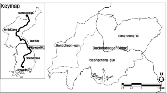
The comparison of the major vegetation distribution on the east and west sides of Baekdudaegan (Fig. 4) shows that the ratio of Q.
mongolica forest is relatively high in the steep and extremely steep areas in the east and that the slow slope, slope and rapid slope areas have a relatively high ratio in the west. The largest ratio of P.
densiflora forest is in the eastern slow slope area, with an even distribution in the slope and rapid slope
while the P. densiflora forest in the west has the highest portion in the slope area and a large portion in the rapid slope area. The P. densiflora Q.
variabilis forest makes up a high ratio of the slope
and rapid slope areas in the east. The slow slope area
has the highest ratio of the western deciduous
broad-leaved forest, with even distributions of the
slope and rapid slope areas. This shows a similar
trend to the results of the study by Jang (2007) on the
locational environment in terms of the plant
East side of Baekdudaegan West side of Baekdudaegan Fig. 5. Vegetation analysis according to aspect of Odaesan national park.
sociology, indicating that the distribution tendency of Q. mongolica forest according to the slope is not clear. Yoon (2003) stated that 80% of the P.
densiflora forest is found in areas with less than 20°
following a study on the spatial distribution and prediction of P. densiflora forest in Korea. The east side of Baekdudaegan shows no specific trend but the west side shows a high distribution in the slope (15 20°).
The result of analysis on the aspect of major vegetation areas on the east and west sides of Baekdudaegan (Fig. 5) showed that the Q. mongolica forest is intensively distributed in the east, northwest, north and northeast directions in the east, with even distributions in the west and a relatively high ratio in the west, northwest, southwest and south directions.
Like the Q. mongolica forest, P. densiflora forest in the east part has a high distribution from the east to the northwest through the north and a relatively high distribution from the northwest to the south through the southwest in the west. P. densiflora Q.
variabilis forest is evenly distributed in all directions except in the south and southwest in the east area while the deciduous broad-leaved forest is evenly distributed in all directions except the southwest in the west area. The major vegetation distribution on both sides of Baekdudaegan depends on the ratio of
the aspect and there is no clear difference between the east and west. Lee (1995) stated that the Q.
mongolica forest is mainly distributed to the south and north slopes and is intense in the east (12.5%) and northwest directions (15.3%) on the east side of Baekdudaegan. The west direction (15.3%) has a high ratio on the west of the ridge while the north and west directions have a high portion with less sunlight.
In a study on the spatial feature and prediction of P.
densiflora forest in Korea, Yoon (2003) reported that there is no significant difference according to the direction with 20.5% in the north and 27.2% in the south direction, unlike a previous study which found that the distribution of P. densiflora forest is low in the north and high in the south. The study also did not find any features specific to either area.
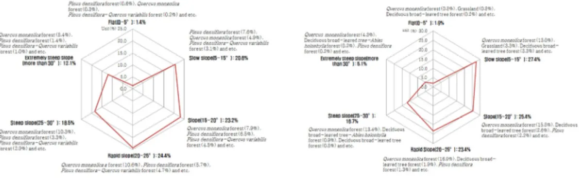
The actual vegetation distribution analysis of the micro-landform (Fig. 6) showed that the Q.
mongolica forest comprises a high ratio of the ridge in the east and west Baekdudaegan and the P.
densiflora forest shows a similar trend due to taking up a high ratio of the ridge and slope. The P.
densiflora Q. variabilis forest in the east is evenly
distributed on the ridge, valley and slope while the
deciduous broad-leaved forest in the west has a high
rate in the valley. In a study on Amami Oshima in the
western part of Japan, Hara et al. (1996) stated that
East side of Baekdudaegan West side of Baekdudaegan
Fig. 6. Vegetation analysis according to micro-landform of Odaesan national park.
the micro-landform distribution from the ridge to the valley affects the vegetation pattern. Both sides have a distribution of P. densiflora forest by the land climax of the ridge (Bae and Hong, 1996), and P.
densiflora Q. variabilis forest has a higher ratio than the deciduous broad-leaved forest in the east.
Ohsawa (1993) stated that this distribution is affected by the fact that the evergreen coniferous forest is largely distributed in the oceanic climate.
4.2. Climate and current vegetation
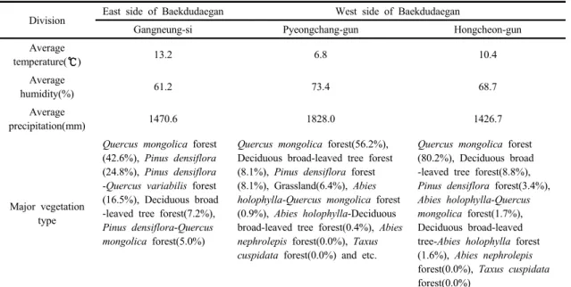
The result (Table 2) of actual vegetation analysis according to the climate shows that the annual average temperature, humidity and precipitation in the east of Baekdudaegan are 13.2 , 61.2% and 1,470.6 mm, respectively. Q. mongolica forest (42.6
%) has the highest distribution, followed by the P.
densiflora forest (24.8%), P. densiflora Q.
variabilis forest (16.5%), deciduous broad-leaved forest (7.2%) and P. densiflora Q. mongolica forest (5.0%). Pyeongchang-gun, on the west side of the ridge, has an annual average temperature, humidity and precipitation of 6.8 , 73.4% and 1,828.0 mm, respectively and its major vegetation types include the Q. mongolica forest (56.2%), deciduous broad-leaved forest (8.1%), P. densiflora forests (8.1%), grassland (6.4%), A. holophylla Q.
mongolica forest, A. nephrolepis forest and T.
cuspidata forest. Hongcheon-gun has an annual average temperature, humidity and precipitation of 10.4 , 68.7% and 1,426.7 mm, respectively and its major vegetation type includes Q. mongolica forest (80.2%), P. densiflora forest (3.4%), A. holophylla Q. mongolica (1.7%), deciduous broad-leaved forest
A. holophylla (1.6%), A. nephrolepis forest and T.
cuspidata forest.
The east side of Baekdudaegan, with high annual average temperature and low precipitation, has a relatively high distribution of P. densiflora forests and P. densiflora Q. variabilis forests and is included in the southern temperate zone with a warmth index of 115.4 ( . month). Pyeongchang -gun, on the west side of Baekdudaegan with low temperature and high humidity and precipitation is included in the northern temperate zone with a warmth index of 67.3 ( . month). Hongcheon-gun is included in the southern temperate zone with a warmth index of 103.3 ( . month). The major vegetation includes Q. mongolica forests, deciduous broad-leaved forests and deciduous broad-leaved A. holophylla forests.
The results of overlay analysis of the topography
(elevation, slope, direction, micro-landform) and
climate (temperature, humidity, precipitation) in the
Division East side of Baekdudaegan West side of Baekdudaegan
Gangneung-si Pyeongchang-gun Hongcheon-gun
Average
temperature( ) 13.2 6.8 10.4
Average
humidity(%) 61.2 73.4 68.7
Average
precipitation(mm) 1470.6 1828.0 1426.7
Major vegetation type
Quercus mongolica forest (42.6%), Pinus densiflora (24.8%), Pinus densiflora -Quercus variabilis forest (16.5%), Deciduous broad -leaved tree forest(7.2%), Pinus densiflora-Quercus mongolica forest(5.0%)
Quercus mongolica forest(56.2%), Deciduous broad-leaved tree forest (8.1%), Pinus densiflora forest (8.1%), Grassland(6.4%), Abies holophylla-Quercus mongolica forest (0.9%), Abies holophylla-Deciduous broad-leaved tree forest(0.4%), Abies nephrolepis forest(0.0%), Taxus cuspidata forest(0.0%) and etc.
Quercus mongolica forest (80.2%), Deciduous broad -leaved tree forest(8.8%), Pinus densiflora forest(3.4%), Abies holophylla-Quercus mongolica forest(1.7%), Deciduous broad-leaved tree-Abies holophylla forest (1.6%), Abies nephrolepis forest(0.0%), Taxus cuspidata forest(0.0%)
Table 2. Vegetation analysis according to atmosphere of Odaesan national park
east and west areas of Baekdudaegan in Odaesan National Park indicate that the environment like the topographic elements including the elevation and micro-landform as well as climate elements like the annual average temperature, humidity and precipitation affect the vegetation distribution on both sides of the ridge. The difference in vegetation distribution according to the aspect and slope is not clear.
This study is a case study of investigating the vegetation distribution depending on the climate and topography on both sides of Baekdudaegan and although this study has limitation to only show the tendency of relationship between environment and vegetation due to the GIS overlay analysis based on the vegetation polygon, it would be utilized as fundamental data for future vegetation management studies.
REFERENCES
Bae, K. H., Hong, S. C., 1996, Structure and dynamics of Pinus densiflora community in Mt. Kaya, J. Kor. For.
Soc., 85(2), 260-270.
Bonham-Carter, G. F., 1994, Geographic information systems for geoscientists: Modeling with GIS, pergamon press, New York, 398.
Byun, D. W., Lee, H. J., Kim, C. H., 1998, Vegetation pattern and successional sere in the Forest of Mt. Odae, Kor. J. Ecol., 21(3), 283-290.
Carver, S. J., 1991, Integrating multi-criteria evaluation with geographical information systems, Int. J. Geogr.
Inf. Syst., 5(3), 321-339.
Chang, L. W., Chiu, S. T., Tang, K. C., Wang, H. H., Hwong, J. L., 2012, Changes of plant communities classification and species composition along the micro-topography at the Lienhuachih Forest dynamics plot in the central Taiwan, Taiwania, 57(4), 359-371.
Choi, J. W., Kim, K. W., Yeum, J. H., Hwang, W. S., 2015, Plant community structure from the Jilmoi wetlands to the Donghae observatory, Baekdudaegan mountains, Kor. J. Env. Eco., 29(2), 251-263.
Choi, S. H., Kwon, J. O., Min, S. H., 1996, Plant community structure analysis in Noinbong area of Odaesan National Park, Kor. J. Env. Eco., 9(2), 156-165.
Choung, Y. S., 1998, Characteristic species distribution of the Baekdoo great mountain chain at Kangwon province, Korea, Kor. J. Ecol., 21(1), 105-112.
Choung, Y. S., Ro, C. H., Oh, H. K., 2004, Vegetation distribution and community classification in Baekdudaegan of southern part of Gangwon-do, J.
Basic Sci., 14, 113-132.
Cogbill, C. V., White, P. S., 1991, The latitude-elevation relationship for spruce-fir forest and treeline along the Appalachian mountain chain, Vegetatio., 94(2), 153-175.
Collins, M. G., Steiner, F. R., Rushman, M. J., 2001, Land-use suitability analysis in the United States:
Historical development and probising technological achievements, J. Environ. Manage., 28(5), 611-621.
Han, B. H., Choi, J. W., Noh, T. H., Kim, D. W., 2015, The structure of plant community in Jungdaesa-Birobong area, Odaesan national park, Kor. J. Env. Eco., 29(2), 251-263.
Hara, M., Hirata, K., Fujihara, M., Oono, K., 1996, Vegetation structure in relation to micro-landform in an evergreen broad-leaved forest on Amami Ohshima island, south-west Japan, Ecol. Res., 11(3), 325-337.
Hou, H. Y., 1983, Vegetation of China with reference to its geographical distribution, Ann. Mo. Bot. Gard., 70, 509-549.
Hwang, K. M., Lee, J. M., Kim, J. H., 2012, Community classification and successional trends in the natural forest of Baekdudaegan in Gangwon province -focused on Hyangrobong, Odaesan, Seokbyeongsan, Dutasan, Deokhangsan and Hambaeksan-, J. Agric.
Life. Sci., 46(4), 41-55.
Im, Y. J., Kim, J. U., 1992, Vegetation of Jirisan (Mt.), Chungang University Press, Seoul, Korea, 467.
Jang, G. J., 2007, Phytosociological studies on the Quercus mongolica forest in Korea, Ph.D. Dissertation, Gangwon National University, Chuncheon, Korea.
Jiang, H. Q., 1980, Distributional features and zonal regularity of vegetation in Yunnan, Acta. bot.
Yunnanica, 2(2), 142-151.
Kikuchi, T., Miura, O., 1993, Vegetation patterns in relation to micro-scale landforms in hilly land regions, Vegetatio., 106(2), 147-154.
Kim, G. T., Choo, G. C., 2003, Vegetation structure of mountain ridge from Nogodan to Goribong in Baekdudaegan, Korea, Kor. J. Env. Ecol., 16(4), 441-448.
Kim, G. T., Choo, G. C., Um, T. W., 1996, Studies on the
structure of forest community at Sangwonsa, Pirobong, Horyongbong area in Odaesan national park, Kor. J. Env. Eco., 10(1), 151-159.
Kira, T., 1991, Forest ecosystems of east and southeast asia in a global perspective, Ecol. Res., 6(2), 185-200.
Korea Forest Research Institute, 2003, Ecological aspects of Baekdu mountains in Korea and delineation of their management and conservation area, Korea Forest Research Institute, Seoul, Korea, 420.
Korea Forest Service, 2017, http://www.forest.go.kr Lee, C. B., Chun, J. H., Song, H. K., Cho, H. J., 2013,
Altitudinal patterns of plant species richness on the Baekdudaegan mountains, South Korea: Mid-domain effect, area, climate and Rapoport’s rule, Ecol. Res., 28(1), 67-79.
Lee, K. J., Kim, J. S., Choi, J. W., Han, B. H., 2008, Vegetation structure of Abies holophylla forest near Woljeong temple in Odaesan national park, Kor. J.
Env. Ecol., 22(2), 173-183.
Lee, S., 2000a, A Study on characteristic of forest vegetation and site in Mt. Odae (1), J. Kor. For. soc., 89(2), 173-184.
Lee, S., 2000b, Site of plant community in Tongdaesan - A Study on characteristic of forest vegetation and site in Mt. Odae (2), J. Kor. For. soc., 89(5), 552-563.
Lee, S. D., Hong, S. H., Kim, J. S., 2012, Plant community structure of Daetjae (hill) Baekbongryung(ridge), the Baekdudaegan mountain, Kor. J. Env. Ecol., 26(5), 719-729.
Lee, W. C., 1995, Quercus mongolica Forest’s Plant, Sumun Press, Seoul, Korea, 133-148.
Marcu, M., Huber, V., 2003, Air thermal stratification in the depression area forms, “Depression Effect”, phytogeographical implications, Analele ICAS, 46(1), 141-150.
Ministry of Environment, 2002, Study on effective management method of Baekdudaegan, Ministry of Environment, Seoul, 324.
Neilson, R. P., 1995, A Model for predicting continental -scale vegetation distribution and water balance, Ecol.
Appl., 5(2), 362-385.
Ohsawa, M., 1990, An Interpretation of latitudinal patterns of forest limits in South and East Asian mountains, J. Ecol., 78(2), 326-339.
Ohsawa, M., 1993, Latitudinal pattern of mountain
vegetation zonation in southern and eastern Asia, J.
Veg. Sci., 4(1), 13-18.
Park, I. H., Ryu, S. B., Kim, R. H., 1996, Forest structure in relation to altitude and part of slope in a valley forest at Odaesan national park, Kor. J. Env. Eco., 9(2), 126-132.
Pereira, J. M. C., Duckstein, L., 1993, A Multiple criteria decision-making approach to GIS-based land suitability evaluation, Int. J. Geogr. Inf. Syst., 7(5), 407-424.
Peterson, D. L., Schreiner, E. G., Buckingham, N. M., 1997, Gradients, vegetation and climate: Spatial and temporal dynamics in the Olympic mountains, U.S.A., Glob. Ecol. Biogeogr. Lett., 6(1), 7-17.
Sharma, A., Tiwari, K. N., Bhadoria, P. B. S., 2011, Determining the optimum cell size of digital elevation model for hydrologic application, J. Earth Syst. Sci., 120(4), 573-582.
Shin, K. H., 2006, In Jiri-mountain national park, Southern Korea-Analysis of spatial relationship between environmental factors and vegetation distribution using DEM, J. Kor. Geomor. Assoc., 13(1), 85-95.
Store, R., Kangas, J., 2001, Integrating spatial multi-criteria evaluation and expert knowledge for GIS-based habitat suitability modelling, Landscape Urban Plan., 55(2), 79-93.
Vloebeld, M., Leemans, R., 1993, Quantifying feed-back processes in the response of the terrestrial carbon cycle to global change: The modeling approach of IMAGE-2.0, Water Air Soil Poll., 70, 615-628.
Yang, B. G., 1997, Concept of Baekdudaegan of Joseon Dynasty, J. Chintan. Soc., 83, 85-106.
Yeon, M. H., Suh, M. H., Yang, K. C., Choi, S. K., Shim, J.
K., 2006, Distribution of plant communities of Mt. Jiri with its geomorphological variation, J. Kor. Geomor.
Assoc., 13(4), 57-67.
Yim, K. B., Lee, S. W., 1975, Temperature factor in silvicultural view point in Korea - Especially on warmth and cold index -, J. Kor. For. Soc., 25, 1-12.
Yoo, J. E., Lee, J. H., Kwon, K. W., 2003, An Analysis of forest community and dynamics according to elevation in Mt. Sokri and Odae, Kor. J. Agric. For.
Meteorol., 5(4), 238-246.
Yoon, J. H., 2003, Characteristics and change prediction of spatial distribution of Pinus densiflora stands in Korea: Emphasis on impacts of topography, climate, and soil factors, Ph.D. Dissertation, Korea University, Seoul, Korea.
Yuste, J. C., Janssens, I. A., Carrara, A., Meiresonne, L., Ceulemans, R., 2003, Interactive effects of temperature and precipitation on soil respiration in a temperate maritime pine forest, Tree Physiol., 23(18), 1263-1270.