157
JOURNALOF KOREAN FOREST SOCIETY ISSN 0445-4650(Print), ISSN 2289-0904(Online) http://e-journal.kfs21.or.kr
덕유산 일대 천연림의 산림형 분류와 천이경향
황광모1·정상훈2·김지홍1*
1강원대학교 산림경영학과, 2국립산림과학원 산림생산기술연구소
Forest Type Classification and Successional Trends in the Natural Forest of Mt. Deogyu
Kwang Mo Hwang
1, Sang Hoon Chung
2, and Ji Hong Kim
2*1Department of Forest Management, Kangwon National University, Chuncheon 24341, Korea
2Forest Practice Research Center, National Institute of Forest Science, Pocheon 11186, Korea
요 약: 덕유산 백암봉 일대의 천연림을 대상으로 산림형을 구분하고, 각 산림형별 생태적 특성을 파악하여 천이경 향을 제시하였다. 사분각법을 이용하여 225개의 표본점에서 식생자료를 수집하였으며, 다양한 다변량 통계분석(Cluster 분석, 지표종분석, 다중판별분석 등)을 실시하여 산림형을 구분하였다. 그 결과, 연구대상지는 5개의 산림형으로 분 류되었고, 상층의 우점비율 및 입지환경에 따라 능선부에서는 신갈나무림, 계곡부에서는 들메나무-물푸레나무-층층나 무림과 들메나무림, 사면하부에서는 졸참나무-소나무-신갈나무림, 소나무림 등이 분포하여 입지조건에 따라 수종구성 차이가 뚜렷한 것으로 나타났다. 산림유형별 생태적, 환경적 특성을 근거로 천이경향을 추정한 결과, 현재의 산림형 은 신갈나무림, 들메나무림, 중생혼합림, 참나무-서어나무림 등으로 천이가 진행될 것으로 예상되었다.
Abstract: This study was carried out to classify the current forest cover types and to propose the successional trends in the natural forest of Mt. Deogyu. The vegetation data were collected by the point-centered quarter method. The forest cover types were classified by various multivariate statistical analysis methods such as cluster analysis, indicator species analysis and multiple discriminant analysis. This forests were classified into five forest types by the species composition of upper layer and topographic positions: Quercus mongolica forest in the ridge, Fraxinus mandushurica-F. rhynchophylla-Cornus controversa forest and F. mandushurica forest in the valley, the Q. serrata - Pinus densiflora - Q. mongolica forest and P. densiflora forest in the low-slope. As a result of the forest successional trends depending on ecological and environmental characteristics in each forest type, the current forest types were expected that the forest succession would be proceeded toward Q. mongolica forest, F. mandshurica forest, mixed mesophytic forest, and oak-Carpinus laxiflora forest.
Key words: classification of forest types, ecological characteristics, natural forest, succession trends, various multivari- ate statistical methods
서 론
최근 국립공원 탐방객 입장료 폐지와 주 5일 근무제 시 행 등의 사회적 여건이 좋아지고 산림 복지와 치유가 주 목 받으면서 국립공원 이용이 급속도로 증가하여 인위적 인 산림 훼손압력이 높아지고 있다. 특히 덕유산은 일제 치하에서 전쟁 물자 충족을 위해 1930년까지 대규모 벌목 이 무차별 실시된 지역이며, 그 후로도 임산연료, 한국전 쟁 중 작전상 벌채, 전쟁 후 복구사업을 위한 목재공급 등 으로 산림이 파괴된 전력이 있다(Korea Forest Policy
Research Association, 1975).
덕유산(1,614 m)은 식물분포학상 중부아구와 남부아구 에 속하여 남한 중·남부지역의 식물상이 모두 나타나며 (Lee and Yim, 1978), 해발고도가 높아 아고산기후가 나타 나고 아고산기후에 적응한 북방계식물들이 생육하는 등 독특한 경관 및 식물상을 보인다(Korea National Park Service, 2012). 그러나 이 지역 산림식생의 대부분은 과거 광범위하고 강도 높은 교란을 받은 2차림인데다 1970년 대 이후부터는 제도적 보호를 받아와 다양한 산림형과 임 분 발달 단계를 나타내고 있다. 특히 해발고, 지형, 사면 등과 같은 입지환경에 따라 수종구성 차이가 심한 현상이 여러 연구자들에 의해 공통적으로 확인되었다. 해발고가
*Corresponding author E-mail: [email protected]
낮은 계곡부와 사면하부에서는 소나무, 졸참나무, 굴참나 무 등이, 해발고가 높은 능선부나 사면상부에서는 신갈나 무가 각각 우점하며, 그 사이 사면중부 이상에서는 들메 나무가 분포하는 것으로 보고되었다(Song et al., 1987;
Song, 1990; Kim et al., 1994a; Park et al., 1994; Kim and Kil, 1997; Korea National Park Service, 2004; 2012;
Park and Choi, 2004; Kim et al., 2010). 아고산지대 식 생에 관한 연구는 Kim et al.(1994b), Moon(2001), Kim and Choo(2004) 등이 실시하였고, 구상나무림은 Kim and Choo(1999), 주목나무림은 Jang et al.(2004), 가문비나무 림은 Song et al.(2011), Han et al.(2012) 등이 각각 조사 하여 발표하였다. 그 외 식생연구로 Kim et al.(2011), Choi et al.(2013), Kim et al.(2013) 등이 각각 덕유산 일 원의 현존 식생도를 작성하여 수종 분포 양상을 설명하고, 주요 수종의 흉고직경 분포도나 분포면적을 이용하여 소 나무군집이 참나무류에 의해 쇠퇴하는 산림천이 경향을 예상하였다. 그리고 극상수종으로 신갈나무, 들메나무, 서 어나무 등을 제시하여 입지조건에 따라 이들 수종으로 천 이가 진행될 것으로 보고하였다.
넓은 의미에서 천이는 자연계에서 변화와 그 변화의 원 인과 방향을 이해하는 것을 포함하지만(Shugart, 1984), 일 반적으로는 교란중이거나 교란 후의 종구성과 양적 변화 를 의미하기도 한다(McCook, 1994). 특히, 산림생태계는 현재의 산림 구조와 종구성으로 특성을 나타내거나 평가
되는데, 천이경향을 예측함으로서 효율적인 산림 관리와 보전에 필요한 수준 높은 식생 정보를 구축할 수 있다. 식 생은 지표면에 생육하고 있는 전체 식물의 집단으로 대개 생육지의 환경과 반응해서 결정된 종들이 모이는 집단 즉, 군집형태로 존재하고 있어 예로부터 이를 유형화 하여 대 상 지역 산림 생태계 보전 및 관리를 위한 기본 단위로 활 용되고 있다(Lee et al., 2006).
본 연구는 덕유산 일대 천연림을 대상으로 생태적 산림 경영을 실현하고 향후 관리 방향을 모색하기 위한 기초자 료를 제공하고자 산림식생 유형을 파악하고, 산림유형별 천이경향을 제시하였다.
자료 및 방법
1. 연구대상지 및 자료수집
연구대상지는 행정구역상 전라북도 무주군과 경상남도 거창군의 경계에 위치하고 있으며, 이 지역의 기후는 연 평균기온 11.5oC, 연평균강수량은 1,265.9 mm이며 강수량 의 50~60%가 여름에 집중된다(Korea National Park Service, 2012).
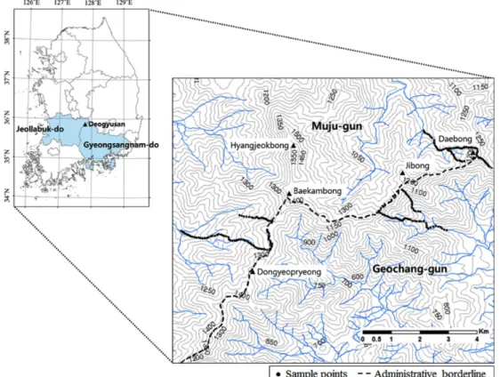
식생조사는 덕유산국립공원 백암봉(1,503 m)을 중심으 로 남서 방향으로 이어진 백두대간 내 동엽령, 백암봉, 지 봉, 대봉 일대의 천연림을 대상으로 하였다(Figure 1). 조 사방법은 우리나라의 험준한 지형적 특성을 고려하여 넓
Figure 1. Location of the research area in Mt. Deogyu. The sample points(black dots) were evenly distributed in the valley, slope and ridge.
은 연구대상지에서 효율적으로 표본을 추출할 수 있는 사 분각법(Point-centered quarter method; Brower and Zar, 1977)을 이용하였다. 표본점 간 약 40~60 m의 간격을 유 지하면서 능선 · 산복 · 계곡 등의 지형이 균일하게 포함 되도록 하여 총 225개의 표본점을 설정하였다. 각 표본점 4방위에서 수직층위별(상, 중, 하) 표본점에서 가장 가까 운 목본수종을 식별하고 흉고직경 및 수고, 해발고도, 사 면방위 등을 조사하였다.
2. 분석방법
수집된 식생정보를 바탕으로 유사한 생태적 속성을 지 닌 산림형으로 구분하기 위해 Cluster분석을 실시하였다.
적절한 산림유형의 수를 추정하기 위해 Dufrene and Legendre(1997)가 고안한 지표종분석을 실시하였으며, 지 표종분석에 의해 결정된 산림유형 개수의 적절성 여부를 판단하기 위해 다중판별분석을 수행하였다(Chung, 2015).
분류가 완료된 각각의 산림유형별 수종구성을 파악하기 위해 Curtis and Mcintosh(1951)의 중요치 산출방법을 이 용하였으며, 우점 수종의 비율을 바탕으로 각 산림유형에 명칭을 부여하였다(Chung and Kim, 2013; Hwang et al., 2015). 산림유형별 입지환경과 종다양성 및 수직적 층위 구조를 파악하여 산림 천이계열을 추정하였다(Figure 2).
군집분석과 지표종분석은 PC-ORD 6.0(McCune and Mefford, 2011), 다중판별분석은 SPSS 20.0(IBM SPSS Statistics, 1989-2011), 수종구성과 종다양성지수 분석은 Microsoft Excel 2010(Microsoft Corporation, 2010)을 이 용하였다.
결과 및 고찰
1. 산림형 분류
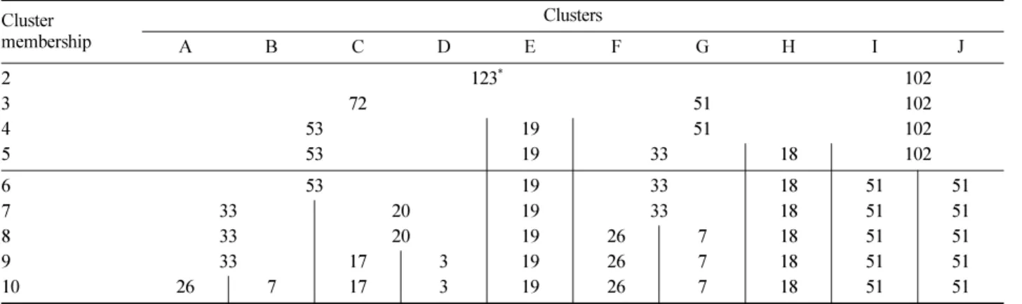
225개의 표본점에서 수집된 식생정보를 바탕으로 군집 분석을 실시한 결과, 2~10개의 Cluster로 분류되었다(Table 1). Cluster의 수가 증가 할수록 각 Cluster에 포함되는 표 본점의 개수가 감소하였다. Cluster의 수는 정보의 손실과 수종간의 생태적인 관련성을 종합적으로 해석할 수 있는 단순함을 적절하게 절충하는 기준이 되기 때문에(Chung and Kim, 2013), 연구자의 주관적인 판단에 의해 결정되 면 군집분석 결과에 부정적인 영향을 미칠 수 있다.
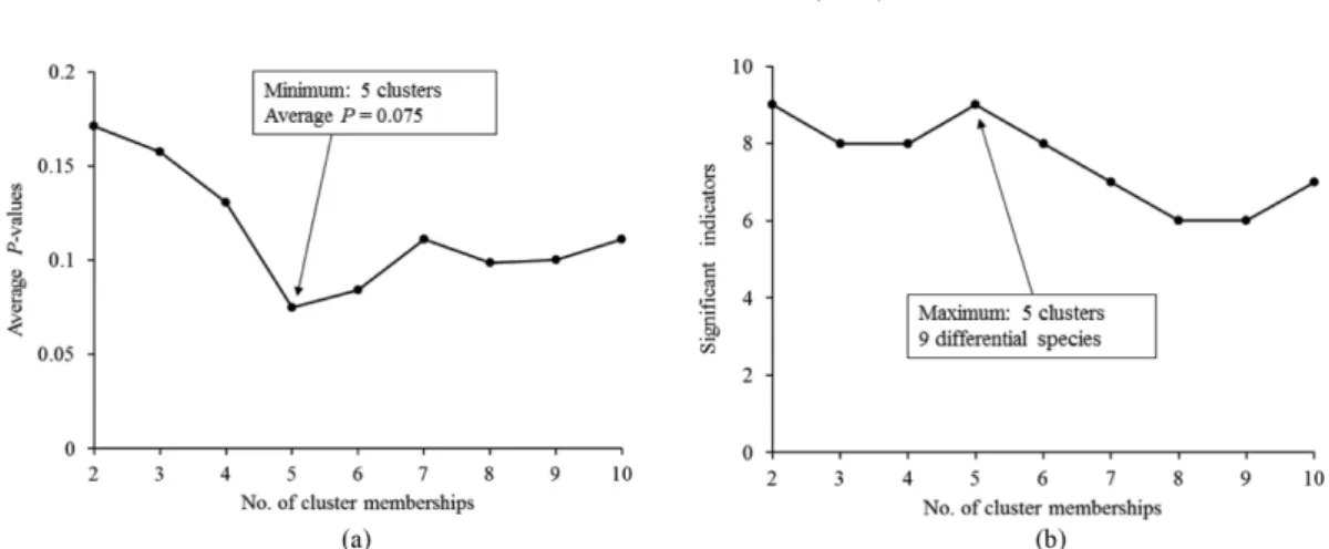
적정한 Cluster의 수를 추정하기 위해 군집분석에서 산 출된 2~10개의 Cluster에 대한 13개 수종별 지표종지수의 평균 P값을 산출하였으며(Figure 3a), Cluster별로 유의수 준(P<0.05)을 만족시키는 수종의 개수를 나타내었다(Figure 3b). 적절한 Cluster의 수는 Cluster 수에 대한 지표종지수 의 평균 P값이 가장 낮고, 유의수준(P<0.05)을 만족시키 는 지표종의 개수가 가장 많을 때 결정된다(McCune and Grace, 2002). Cluster의 수가 5개 일 때 평균 P값이 0.075로 가장 낮게 나타났으며, 유의수준을 만족시키는 지 표수종의 수가 9개로 가장 높게 분석되어, 적절한 Cluster 의 수는 5개인 것으로 파악되었다.
5개의 예측집단으로 다중판별분석을 실시한 결과, 예측 집단에 분포하는 표본점의 97%가 Cluster분석 및 지표종 분석에 의해 산출된 5개의 Cluster들과 통계적으로 유의한 수준에서 일치하는 것으로 분석되어 5개의 산림형으로 구 분한 것이 적절함을 뒷받침하였다(Table 2).
Figure 2. The sequence of analysis.
Table 1. The number of sample points assigned to each cluster membership.
Cluster membership
Clusters
A B C D E F G H I J
2 123* 102
3 72 51 102
4 53 19 51 102
5 53 19 33 18 102
6 53 19 33 18 51 51
7 33 20 19 33 18 51 51
8 33 20 19 26 7 18 51 51
9 33 17 3 19 26 7 18 51 51
10 26 7 17 3 19 26 7 18 51 51
*No. of sample points for each cluster membership.
2. 상층 수종구성과 산림형 명명
산림형 분류는 자연상태에서 산림을 구성하는 수종들 이 어떤 경향을 가지고 집단을 이루거나 상관관계를 맺고 있다는 점에 착안하여 현재의 구성수종을 중심으로 유사 한 임분들끼리 동일한 산림식생단위로 분류하는 방법이 다(Lee et al., 1999; Chung et al., 2014; Chung et al., 2015). 현재 상층을 구성하는 30개의 수종 가운데 상위 5 개 수종(신갈나무: 35.4%, 소나무: 12.7%, 들메나무:
11.0%, 졸참나무: 10.9%, 물푸레나무: 5.3%)이 전체의 3/4 을 우점하였으며 이들 수종의 분포 정도에 따라 산림형이 다르게 분류되었다(Table 3). 다른 국립공원과 비교할 때 들메나무가 많이 분포하는 것은 본 조사지의 특징으로 평 가된다(Kim et al., 2011).
주요수종의 상대밀도(RD), 상대빈도(RF), 상대피도(RC) 등을 통해서 각 수종들의 생육특성을 가늠할 수 있는데, 신갈나무는 상대밀도가 높고 상대빈도가 낮아 집중분포 형태를 띠며, 소나무는 상대밀도에 비해 상대피도가 두 배 에 이르러 직경이 큰 개체들이 모자이크 형태로 분포하는 경향을 나타내었다. 그 외 들메나무와 졸참나무는 생장 상 태와 분포양상이 유사한 것으로 파악되었다.
상층 구성 수종의 중요치를 기준으로 25% 이상 우점하 면서 2~3개 수종 중요치 합이 50% 이상일 때 다수의 수 종명을 이용하였으며, 한 수종이 75%이상 우점하면 단일 수종으로 산림형을 명명하여 군집단위의 수종구성 특성 을 간접적으로 나타내었다. 산림형 명명의 기준은 산림경 영에서 일반적으로 사용하는 입목지 구분 비율과 Braun- Blanquet(1964)의 우점도 계급 비율에 기초하였다(Hwang et al., 2012; Lee et al., 2014).
산림형 명명기준에 따라 분류한 결과, 덕유산 일대 천 연림은 5개의 산림형으로 나타났으며 신갈나무림, 졸참나 무-소나무-신갈나무림, 들메나무-물푸레나무-층층나무림, 소나무림, 들메나무림 순으로 많은 표본점을 포함하였다 (Figure 4).
신갈나무림, 소나무림, 들메나무림 등은 상층에서 각각 신갈나무가 76.7%, 소나무가 75.7%, 들메나무가 80%를 차지하는 것으로 나타났다. 졸참나무-소나무-신갈나무림 과 들메나무-물푸레나무-층층나무림 등은 상층에서 이들 의 수종이 62.6%, 54.1%를 각각 점유하는 것으로 파악되 었다.
3. 산림형별 생태적 속성
해발고도와 지형적 위치에 따른 산림형들의 분포(Table 4)와 종다양성지수 분석(Figure 5)을 바탕으로 각 산림형 Figure 3. Result of indicator species analysis from step 2 to 10 during the clustering process. (a) Change in P value after 4,999 permutations of the Monte Carlo test averaged across 13 species, (b) Number of indicator species with P < 0.05.
Table 2. The confusion matrix summarizes the reclassification of the predicted group membership.
Classified cluster
Predicted group membership
1 2 3 4 5
A 90.6* 1.9 7.5 - -
B 5.3 94.7 - - -
C - 2.0 96.1 - 2.0
D - - - 100 0
E - - - - 100
*Percentages in rows represent the classification into the clusters given in columns (correct classification in bold). Overall classification success was 96.4%.
Table 3. Importance value of major tree species in overstory.
Scientific name RD* RF RC IV
Quercus mongolica 43.1 28.7 34.4 35.4
Pinus densiflora 10.1 8.4 19.7 12.7
Fraxinus mandshurica 11.9 10.9 10.4 11.0
Quercus serrata 9.3 10.5 12.9 10.9
Fraxinus rhynchophylla 5.4 7.3 3.3 5.4
Others (25) 20.2 34.2 19.3 24.6
*RD:Relative density, RF:Relative frequency, RC:Relative coverage.
별 생태적 속성을 파악하였다. 전체적으로 각 산림형의 해 발고, 지형 분포 범위가 덕유산 전체나 일부 지역에서 선 행된 연구결과와 유사한 경향으로 나타났다. 해발고와 수 분요소가 식생간 차이를 나타내었으며, 남사면에서는 신 갈나무, 소나무, 졸참나무, 굴참나무 순으로 중요치가 높 게 나타나고, 북사면에서는 신갈나무, 들메나무, 당단풍나 무, 졸참나무, 서어나무 순으로 중요치가 높게 나타났다.
해발고 700 m 이하 저지대에서는 소나무, 졸참나무, 굴참 나무 등의 중요치가 높게 나타났으며 해발고가 높아짐에 따라 이들의 중요치는 낮아지고 신갈나무, 들메나무의 중 요치는 높아지는 것으로 보고하였다(Song et al., 1987;
Song, 1990; Kim et al., 1994a; Park et al., 1994; Kim and Kil, 1997; Korea National Park Service, 2004; 2012;
Park and Choi, 2004; Kim et al., 2010).
해발고와 사면부위가 높아짐에 따라 토양수분이 감소 하며, 수종별 내성범위 차이와 종간 경쟁으로 연속된 산 림군집의 구조와 종다양성이 달라지게 된다(Webster, 1961;
Whittaker and Niering, 1975; Katagiri and Tsutsumi, 1978;
Montalvo et al., 1991; Korea National Park Service. 2004).
종다양성은 산림군집의 구조적인 복잡성, 외부 교란 요인 으로부터의 안정성, 그리고 산림 발달 과정상 성숙도와 비 례하는 경향이 있다(Odum 1969; Louks, 1970; Bazzaz, 1979; Kim et al., 2013).
신갈나무림은 해발고 831~1,321 m의 범위에 분포하였 으며, 평균해발고는 1,107 m로 전체 산림형 가운데 가장 높게 나타났고 지형적으로는 주로 능선부와 사면 상부에 서 생육하였다. 졸참나무-소나무-신갈나무림은 주로 계곡 부와 사면하부에 분포하였으며 해발고 범위는 602~1,079 m, 평균해발고는 842 m로 분포양상이 신갈나무림과 이질적 인 것으로 나타났다. 소나무림은 주로 사면하부와 계곡부 에서 분포하였으며 해발고 범위는 583~1,154 m, 평균해 발고는 812 m로 전체 산림형 가운데 가장 낮은 것으로 나 타났다. 들메나무-물푸레나무-층층나무림과 들메나무림은 주로 계곡부와 계곡부와 인접한 사면에 분포하였으며 해 발고 범위는 693~1,214 m, 평균해발고는 1,000 m 내외로 나타났다.
한 가지 수종의 점유 비율이 높은 신갈나무림, 소나무 림, 들메나무림의 종다양성지수가 낮은 반면, 3개 수종이 상층을 우점하는 졸참나무-소나무-신갈나무림과 들메나 무-물푸레나무-층층나무림의 종다양성지수가 높은 것으
*The component ratio of sample points (%), **No. of species, ***QM:
Quercus mongolica, QS: Q. serrata, PD:Pinus densiflora, FM: Fraxinus mandshurica, FR: F. rhynchophylla, CC:Cornus controversa, BD: Betula davurica, BE: B. ermanii, BC: B. schmiditii, AP: Acer pictum subsp.
mono, QV: Q. variabilis, UL: Ulmus laciniata, QA: Q. acutissima.
Figure 4. Importance value (%) of major tree species in overstory by each classified forest type.
Table 4. The topographic position and above sea level (ASL) for each forest type.
Forest type Topographic position (%)
ASL (m) Valley Slope Ridge
QM* 6 27 67 1,107
831-1,321
QS-PD-QM 49 45 6 842
602-1,079
FM-FR-CC 67 30 3 998
693-1,195
PD 21 68 11 812
583-1,154
FM 89 11 - 1,047
771-1,214
*Abbreviations of the forest name were shown Figure 4.
*Abbreviations of the forest name were shown Figure 4.
Figure 5. Species diversity index of each forest type.
로 나타났다(Figure 5). 소나무림과 들메나무림은 생육환 경이 양호한 계곡부에서 주로 조사되어 표본점 수에 비해 다양한 수종이 조사된 것으로 파악되었다. 졸참나무-소나 무-신갈나무림과 신갈나무림의 종 수는 비슷하지만 종다 양성지수에서 차이를 보였는데, 이는 신갈나무림에서 신 갈나무의 높은 우점으로 균재도가 낮아진 것이 원인이라 사료된다.
4. 산림형별 수직 층위구조
다섯 가지 산림형의 중층과 하층에 출현한 주요 수종들 의 중요치를 바탕으로(Table 5) 각 산림형별 미래 수종구 성을 개략적으로 추정하였다.
신갈나무림은 중층에서 신갈나무의 중요치가 가장 높 게 나타나, 외부로부터 특별한 교란이 발생하지 않는다면 현재 신갈나무의 상층 우점율은 계속 유지될 수 있을 것 으로 파악되었다. 하층에서는 철쭉, 노린재나무가 높은 우
점을 나타내었고, 교목 및 아교목 수종은 우점률이 낮아 수직층위 발달단계가 미숙한 것으로 분석되었다.
졸참나무-소나무-신갈나무림은 상층에 이어 중층에서도 신갈나무, 서어나무, 졸참나무 등의 중요치가 높게 나타난 반면 소나무는 후계목이 나타나지 않아 향후 졸참나무, 신 갈나무, 서어나무 등이 상층을 우점할 것으로 파악되었다.
하층에서는 당단풍나무와 쪽동백나무의 중요치가 높게 나 타났다.
들메나무-물푸레나무-층층나무림은 상층의 우점수종 외 에 고로쇠나무, 신갈나무 등 다양한 교목 활엽수종이 중 층을 점유하여, 향후 다양한 수종들의 고른 우점 양상으 로 상층 수종구성이 변화할 것으로 예상된다. 하층에서는 습한 계곡부 전석지에 주로 분포하는 물참대의 중요치가 높게 나타났다.
소나무림 중층에서 소나무의 점유비율이 상층에 비해 현저하게 감소하여 신갈나무, 졸참나무, 서어나무 등의 활 Table 5. Importance values of major tree species in mid and under stories for each classified forest type.
Vertical strata Scientific name Forest types
QM** QS-PD-QM FM-FR-CC PD FM
Mid
Quercus mongolica 42.7 9.9 8.6 18.3 1.8
Acer pseudo-sieboldianum* 10.5 8.0 9.2 1.2 10.0
Fraxinus sieboldiana* 7.1 2.2 2.3 2.8 -
Carpinus cordata * 6.7 6.6 8.9 1.2 2.5
Fraxinus rhynchophylla 6.7 5.7 9.9 1.2 6.9
Styrax obassia* 4.6 16.8 8.0 11.5 3.2
Carpinus laxiflora 0.3 11.9 - 14.4 -
Quercus serrata - 11.8 - 16.6 -
Acer pictum subsp. mono 2.1 3.0 17.6 1.4 8.2
Fraxinus mandshurica 1.2 0.5 13.4 1.7 29.4
Pinus densiflora - - - 15.4 -
Cornus controversa 1.6 3.2 7.5 - 6.0
Others (No. of species) 16.5
(21)
20.4 (17)
14.6 (12)
14.3 (7)
32.0 (13)
Under
Rhododendron schlippenbachii 29.0 5.5 4.0 21.3 -
Symplocos chinensis 15.7 3.0 1.9 4.0 1.8
Lespedeza maximowiczii 7.9 0.4 - 2.1 -
Fraxinus rhynchophylla 5.1 1.8 - 3.2 -
Acer pseudo-sieboldianum* 4.7 12.6 10.6 8.7 15.9
Styrax obassia * 0.3 12.5 1.4 10.7 -
Lindera obtusiloba 1.8 11.7 7.4 6.6 -
Carpinus cordata* 4.2 4.9 3.4 1.5 2.0
Deutzia glabrata 0.8 2.3 17.5 4.6 14.3
Euonymus sachalinensis 1.4 3.4 8.4 1.5 -
Magnolia sieboldii* 2.5 2.6 6.7 - 16.5
Rhododendron mucronulatum 3.0 1.4 - 8.8 -
Fraxinus sieboldiana* 1.9 0.9 0.9 7.8 1.4
Acer pictum subsp. mono 1.4 3.1 4.3 1.7 7.6
Alangium platanifolium - - 2.1 - 6.8
Others (No. of species) 20.3
(25)
33.9 (21)
31.4 (19)
17.5 (11)
33.7 (14)
*Subtree species.**Abbreviations of the forest name were shown Figure 4.
엽수종들과 비슷하여, 향후 이들 활엽수종이 상층을 우점 할 것으로 판단된다. 내음성이 낮은 소나무는 중층을 구 성하고 있는 다른 활엽수종들에 피압되어 상층으로 성장 하기 어려운 것으로 판단되며, 이러한 과정은 소나무림의 일반적인 천이경로로 여겨진다(Kim et al., 2011; Kim et al., 2013; Kim et al., 2015). 하층에서는 철쭉의 중요치가 높게 나타났다.
들메나무림의 상층에 이어 중층에서도 들메나무의 높 은 우점률이 나타나 들메나무 단순림이 계속 유지될 것으 로 판단된다. Cho(1989)는 들메나무가 천연하종에 의해서 치수가 잘 발생되며, 어려서는 음수이나 성장하면서 광선 을 요구하고 맹아력이 강한 특징을 가지고 있다고 보고하 였고, Lee et al.(1994), Yang and Wu(1986), Barnes et al.(1992) 등은 들메나무의 극상림 가능성을 시시한 바 있 다. 하층에서는 함박꽃나무와 물참대의 중요치가 높게 나 타났다.
중·하층에서 아교목 수종인 당단풍나무, 쇠물푸레나 무, 까치박달, 쪽동백나무 등의 중요치가 높은 졸참나무- 소나무-신갈나무림과 들메나무-물푸레나무-층층나무림은 상층 수종구성이 다양해지면서 중·하층 수직층위 발달 도 복잡해질 것으로 사료된다. 졸참나무-소나무-신갈나무 림과 소나무림, 들메나무-물푸레나무-층층나무림과 들메 나무림은 각각 출현하는 수종과 우점하는 수종의 분포 양 상이 유사한 것으로 판단된다.
결 론 : 산림형의 천이 계열 추정
산림형별 생태적 특성(Table 4 and Figure 5)과 중·하 층 수종구성(Table 5)을 근거로 천이경향을 추정한 결과, 덕유산 일대 천연림은 신갈나무림, 들메나무림, 중생혼합 림, 참나무-서어나무림 등으로 산림형이 발달할 것으로 예
상되었다(Figure 6).
신갈나무림과 들메나무림은 현재의 입지조건에서 지속 적으로 유지되고, 들메나무-물푸레나무-층층나무림은 현 재 상층이 다양한 수종에 의해 분산되어 중생혼합림(mixed mesophytic forest)으로 발달할 것으로 예상되었다. 중생혼 합림은 특정한 소수의 수종이 우점하지 않고 여러 가지 수종이 어우러져 일정한 점유율을 유지하는 경향을 보이 는 산림유형을 지칭한다(Braun, 1950; Vankat, 1979;
Barbour and Billings, 1988; European Environment Agency, 2006; Chung et al., 2015). 졸참나무-소나무-신갈나무림과 소나무림은 참나무-서어나무림으로 발달할 것으로 판단 되는데, 이는 두 산림형이 분포하는 해발고와 지형이 유 사하고, 현재 중·하층 수종구성이 비슷한데다 점유율이 늘어날 것으로 예상되는 수종이 중복되는 것을 종합하여 판단한 결과이다.
이들 산림형의 극상단계(the last stage of forest sucession) 는 신갈나무림, 들메나무림, 중생혼합림 등이며, 산림형별 분포 면적이 변화할 것으로 사료된다. 신갈나무는 중부지 역의 냉·온대 낙엽활엽수림과 산악 정상부근의 표징종 이고(Kim, 1992; Yim and Kim, 1992; Korea National Park Service, 2004; Kim et al., 2011; Hwang et al., 2012), 들메나무는 덕유산 식생의 특징으로 평가되며, 이 지역에서 극상림으로 유지될 것으로 판단된다(Lee et al., 1994; Yang and Wu, 1986; Barnes et al., 1992; Kim et al., 2011; Kim et al, 2013). 따라서 신갈나무는 사면상부 나 능선에서, 들메나무는 사면 중부이상의 계곡부에서 지 형적 천이(toposequence succession) 과정을 거치며 순환 및 유지되어 극상림(climax forest)의 역할을 할 것이다. 현 재는 신갈나무림이 가장 넓게 분포하지만 시간이 지날수 록 능선과 사면상부에 국한될 때 까지 면적이 줄어들고, 들메나무림은 현재의 소규모 개체군 수준을 유지할 것으
*Abbreviations of the forest name were shown Figure 4. **CL : Carpinus laxiflora Figure 6. Estimation of succession process based on species composition.
로 판단된다.
소나무림과 졸참나무-소나무-신갈나무림은 참나무류에 의한 소나무의 쇠퇴 및 도태 과정을 거치며(Chung and Hong, 2006; Kim et al., 2011; Hwang et al., 2012;
Chung et al., 2014), 하나의 산림형으로 발달하고 궁극적 으로는 중생혼합림으로 천이가 진행될 것이다. 국부적인 소규모 교란에 의해 수종이 대치되는 순환천이(Cyclic succession)가 발생하면서 산불이나 개벌 같은 대규모 교 란이 없다면 중생혼합림은 극상림을 유지할 것으로 예상 된다(Lim, 2015; Kim et al., 2015).
졸참나무-소나무-신갈나무림과 소나무림 등은 들메나무 -물푸레나무-층층나무림과 달리 ‘소나무의 쇠퇴 및 도태’
라는 하나의 천이계열(sere)을 더 거치기 때문에 중생혼합 림으로 발달하기 까지 더 많은 시간이 소요될 것으로 사 료된다.
References
Barbour, M.G. and Billings, W.D. 1988. North American Ter- restrial Vegetation. Cambridge University Press. pp. 434.
Barnes, B.V., Xu, Z., and Zhuo, S. 1992. Forest ecosystems in an old-growth pine-mixed hardwood forest of the Changbai Shan preserve in northeastern China. Canadian Journal of Forest Research 22: 144-160.
Bazzaz, F.A. 1979. The physiological ecology of plant suc- cession. Annual Review of Ecology and Systematics 10:
351-371.
Braun, E.L. 1950. Deciduous forest of eastern north Amer- ica. Blakiston. Philadelphia. pp. 596.
Braun-Blanquet, J. 1964. Pflanzensoziologie, grundzfige der vegetationskunde, 3rd ed. Springer, Wien-New York. pp 865.
Brower, J.E. and Zar, J.H. 1977. Field and Laboratory Meth- ods for General Ecology. William C. Brown Company.
Iowa. pp. 194.
Cho, M.Y. 1989. Coloured Woody Plants of Korea. Acad- emy Books. Seoul. pp. 415.
Choi, Y.E., Oh, J.G., and Kim, C.H. 2013. Community distri- bution on forest vegetation of the Hyangjeokbong in the Deogyusan National Park. Korean Journal of Ecology and Environment 46(2): 289-300.
Chung, H.L. and Hong, S.K. 2006. Distribution patterns flo- ristic differentiation and succession of Pinus densiflora forest in south Korea: A perspective at nation-wide. Phy- tocoenologia 36(2): 213-229.
Chung, S.H. 2015. The Classification of forest cover types in natural forests of the Baekdaedugan, South Korea. Ph. D.
Thesis. Kangwon University. pp. 140.
Chung, S.H. and Kim, J.H. 2013. The classification of forest cover types by consecutive application of multivariate sta-
tistical analysis in the natural forest of western Mt. Jiri.
Journal of Korean Forest Society 102: 407-414.
Chung, S.H., Hwang, K.M., and Kim, J.H. 2014. Ecological interpretation and estimation of successional trend by characteristics of species diversity and topography for for- est cover types in the natural forest of western Jirisan.
Journal of Korean Forest Society 103(4): 537-546.
Chung, S.H., Hwang, K.M., Sung, J.H., and Kim, J.H. 2015.
Forest type classification and ecological characteristics for areas of Chenwangbong, Songnisan. The Journal of Korean Forest Society 104(3): 375-382.
Curtis, J.T. and Mclntosh, R.P. 1951. An upland forest contin- uum in the prairie-forest boarder region of Wisconsin.
Ecology 32: 476-498.
Dufrene, M. and Legendre, P. 1997. Species assemblages and indicators species: The need for a flexible asymmetrical approach. Ecological Monographs 67: 345-366.
European Environment Agency. 2006. European forest types:
Categories and types for sustainable forest management reporting and policy. Office for Official Publications of the European Communities. Luxembourg. pp. 111.
Han, S.H., Kim, D.H., Kim, G.N., and Yun, C.W. 2012. Nee- dle life span, photosynthetic pigment and nitrogen alloca- tion of Picea jezoensis in Korea. Journal of Korean Forest Society 101(1): 62-68.
Hwang, K.M., Chung, S.H., and Kim J.H. 2015. The classifi- cation and species diversity of forest cover types in the natural forest of the middle part of Baekdudaegan. Jour- nal of Korean Forest Society 104: 14-25.
Hwang, K.M., Lee, J.M., and Kim, J.H. 2012. Community classification and successional trends in the natural forest of Baekdudaegan in Gangwon Province; Focused on Hyangrobong, Odaesan, Seokbyeongsan, Dutasan, Deokhang- san and Hambaeksan. Journal of Agriculture and life Sci- ence 46: 41-55.
IBM SPSS Statistics. 1989-2011. SPSS for Window. Version 20.0. IBM Corp.
Jang, Y.S., Yang, D.C., and Chung, D.J. 2004. Vegetation structure of natural Taxus cuspidata forests in Mt. Duck- Yoo. Korean Journal of Plant Resources 17(1): 58-66.
Katagiri, S. and Tsutsumi T. 1978. The relationship between site condition and circulation of nutrients in forest ecosys- tem (V). The difference in nutrient circulation between stands located on upper part of slope and lower part of slope. Journal of Japanese Forest Society 60: 192-202.
Kim, C.H. 1992. A study on the structure of forest vegeta- tion and the secondary succession in Togyusan National Park, Korea. Ph.D. Thesis. Won Kwang University. pp.
156.
Kim, C.H. and Kil, B.S. 1997. Canonical correspondence analy- sis (CCA) on the forest vegetation of Mt. Togyu National Park, Korea. Journal of Ecology and Environment 20(2):
125-132.
Kim, C.H., Oh, J.G., Choi, Y.E., Lee, N.S., and Kang, E.O.
2013. Study oh the distribution of plant community in the Deogyusan National Park. Korean Journal of Ecology and Environment 46(4): 570-580.
Kim, G.T. and Choo, G.C. 1999. Studies on the structure of forest community in subalpine zone of Togyusan. Korean Journal of Environment and Ecology 13(1): 70-77.
Kim, G.T. and Choo, G.C. 2004. Forest structure of subalpine region from Hyangjeukbong to 2nd Deogyusan in Deogy- usan National Park, Korea. Korean Journal of Environ- ment and Ecology 18(2): 142-149.
Kim, G.T., Kim, J.S., Choo, G.C., and Jin, W.H. 1994a. Stud- ies on the structure of forest community at Paekryunsa- Hyangchokpong area in ToKyusan Naional Park. Korean Journal of Environment and Ecology 7(2): 155-163.
Kim, G.T., Kim, J.S., Choo, G.C., and Um, T.W. 1994b. Stud- ies on the structure of forest community at nature conser- vation area in ToKyusan Naional Park. Korean Journal of Environment and Ecology 7(2): 164-171.
Kim, H.S., Lee, S.M., and Song, H.K. 2010. An analysis of the vegetation on the southern and northern slopes in the Deogyusan National Park. Korean Journal of Environ- ment and Ecology 24(5): 601-610.
Kim, H.S., Lee, S.M., and Song, H.K. 2011. Actual vegeta- tion distribution status and ecological succession in the Deogyusan National Park. Korean Journal of Environ- ment and Ecology 25(1): 37-46.
Kim, J.H., Hwang, K.M., and Kim, S.M. 2013. The evaluation of correlation between disturbance intensity and stand devel- opment by natural forest community type classification.
Journal of Forest and Environmental Science 29: 219- 225.
Kim, J.H., Jin, G., and Chung, S.H. 2015. Stand development pat- terns of forest cover type in the natural Forests of north- ern Baekdudaegan in South Korea. Journal of Forestry Research 26(2): 381-390.
Korea Forest Policy Research Association. 1975. 30-years History of National Greening Project. Dongshin Press. Seoul.
pp 480.
Korea National Park Service. 2004. The final report of natu- ral resources survey in Deogyusan National Park. Seoul.
pp. 786.
Korea National Park Service. 2012. The final report of natu- ral resources survey in Deogyusan National Park. Seoul.
pp. 604.
Lee, J.H., Cho, H.J., and Hur, T.C. 2006. Spatial distribution and vegetation-environment relationship of forest vegeta- tion in Ulleung Island, Korea. Journal of Ecology and Field Biology 29(6): 521-529.
Lee, J.M., Hwang, K.M., and Kim, J.H. 2014. The classifica- tion of forest by cluster analysis in the natural forest of the southern region of Baekdudaegan Mountains. The Journal of Korean Forestry Society 103(1): 12-22.
Lee, K.J., Choi, S.H., Cho, H.S., and Lee, Y.W. 1994. The analysis of the forest community structure of Tokyusan national park; Case study of Peakryunsa-Kumpotan. Korean Jour- nal of Environment and Ecology 7: 135-154.
Lee, K.J., Han, S.S., Kim, J.H., and Kim, Y.S. 1999. Forest Ecology. Hyangmoonsa. Seoul. pp. 395.
Lee, W.T. and Yim, Y.J. 1978. Studies on the distribution of vascular plants in the Korea Peninsula. Korean Journal of Plant Taxonomy 8(Appendix): 1-33.
Lim, S.M. 2015. The estimations of succession index for the natural forest of Jirisan. Master Thesis, Kangwon national University. pp. 66.
Loucks, O. 1970. Evolution of diversity, efficiency, and com- munity stability. Am. Zool. 10: 17-25.
McCook, L.J. 1994. Understanding ecological community succession: Causal models and theories, a review. Vegeta- tio 110: 115-147.
McCune, B. and Grace, J.B. 2002. Analysis of ecological communities. MjM Software Design, Gleneden Beach, Oregon, USA. pp. 300.
McCune, B. and Mefford, M.J. 2011. PC-ORD. Multivariate analysis of ecological data. Version 6.0. MjM Software, Gleneden Beach, Oregon, U.S.A.
Microsoft Excel 2010. 2010. Microsoft Corporation.
Montalvo, J., Casado, M.A., Levassor, C., and Pineda, F.D.
1991. Adaptation of ecological systems: compositional pat- terns of species and morphological and functional traits.
Journal of Vegetation Science 5(2): 655-666.
Moon, H.S. 2001. Studies on the forest vegetation structure in subalpine zone of Mt. Deokyu National Park. Journal of Agriculture & Life Science 35: 47-54.
Odum, E.P. 1969. The Strategy of Ecosystem Development.
Science 164: 262-270.
Park, I.H, and Choi, Y.H. 2004. Forest structure in relation to slope aspect an altitude in the valley forests at Song- gyesa-Motbong-Wolhatan area, Deogyusan National Park.
Korean Journal of Environment and Ecology 18(2): 124- 130.
Park, I.H., Moon, G.S., and Choi Y.C. 1994. Forest structure in relation to altitude and part of slope in a valley forest at ToKyusan area. Korean Journal of Environment and Ecology 7(2): 181-186.
Shugart, H.H. 1984. A Theory of Forest Dynamics: The eco- logical implications of forest succession models. Springer- Verlag, New York. pp. 278.
Song, H.K. 1990. An analysis of vegetation - environment relationships of Mt. Gyeryong and Mt. Deokyu by detrended canonical correspondence analysis. Journal of Korean Forest Society 79(2): 216-221.
Song, H.K., Woo, I.S., Lee, S.W., Min, E.S., and Nam, L.
1987. Study on the forest vegetation of Mt. Deokyu by classification and ordination techniques. Research Reports of Environmental Science and Technology 5: 59-73.
Song, J.H., Jang, K.H., Kim, D.H., and Lim, H.I. 2011. The variation of cone, seed and germination characteristics of Picea jezoensis (Siebold & Zuccarini) carriere popula- tions in Korea. Korean Journal of Plant Resources 24(1):
69-75.
Vankat, J.L. 1979. The natural vegetation of north America.
John Wiley & Sons. New York. pp. 261.
Webster, G.L. 1961. The Altitudinal Limits of Vascular Plants. Ecology 42(3): 587-590.
Whittaker, R.H. and Niering, W.A. 1975. Vegetation of the Santa Catalina Mountains, Arizona. V. biomass, produc- tion and diversity along the elevational gradient. Ecology
56(4): 771-790.
Yang, H. and Wu, Y. 1986. Tree composition age structure and regeneration strategy of the mixed broadleaved Pinus koraiensis (Korean pine) forest in Changbai mountain preserve. In: The temperate forest ecosystem. Edited by Yang, Wang, Jeffers, and Ward 12-20 (ITE sysmposium no. 20) Antu, Jilin Province.
Yim, Y.J. and Kim, J.U. 1992. The vegetation of Mt. Chiri National Park. The Chung-Ang University Press. pp 200.
(Received: January 18, 2016; Accepted: March 26, 2016)