IEG 환경지질연구정보센터
8
0
0
전체 글
(2) Korean Journal of Remote Sensing, Vol.20, No.4, 2004. 중순에 냉핵 와동류 중심수온은 9~10℃ 였다. 와동류의 크기는 직경 150km 정도였으며, 냉핵 와동 류의 수평 분포양상은 50m 등수심 분포와 유사하게 나타났다. 이어도(Socotra Rock) 해역을 중심으 로 동계~춘계에 발생되는 냉핵 와동류의 형성 메카니즘은 중국대륙 연안수와 쿠로시오 난류가 만 나는 경계역에서 수괴간의 힘의 균형, 계절풍 조건 및 해저 지형 분포와 밀접한 관계성이 있는 것으 로 나타났다.. 류와 만나 이루는 경계역에서 난류에 의해 포획,. 1. 서 론. 고립됨을 1999년 5월 NOAA 위성 자료 SST 분포 동중국해(East China Sea)는 중국 중앙부 연안. 에서 포착하였는데, 이어도 근해역에서 중규모 냉. 의 동편에 위치하고 있으며, 면적은 약 752,000. 핵 와동류가 장기간(1999년 5월 초순~6월 중순). km2이다.. 북으로는 황해(Yellow Sea)와 연결되고. 형성됨을 보였다. 그러나 현장 관측자료의 부존으. 양자강과 제주도를 잇는 선으로 황해와 구분되며,. 로 정확한 와동류의 존재 및 시공간 변동을 규명. 대한해협과 연결되는 동해(East Sea)와 구분된다.. 하지는 못했다. 본 연구에서는 동계 동중국해 북. 또한 해저 지형상으로 볼 때 중국 대륙쪽에는 수. 부해역에서 나타나는 중규모 냉핵 와동류의 존재. 심 200m 이하의 광활한 대륙붕이 펼쳐져 있어 좋. 를 위성자료와 현장 관측자료로 증명하고 이의 시. 은 어장이 형성된다(이석우, 1983).. 공간적 변동 양상을 분석 연구하고자 하였다.. 동중국해는 한국, 중국, 일본 등 연안 국가가 많 은 혜택을 받는 해양어족 자원의 보고이며, 중국. 2. 자료 및 방법. 대륙 연안수와 쿠로시오(Kuroshio)가 만나 그 경 계역에서 해황변동이 심한 해역이다. 대륙붕 경계 해역에서 와동류가 발생됨을 현장관측자료와 최. 동중국해 북부해역에서의 중규모 냉핵 와동류. 근에는 위성관측 자료를 이용하여 조사 연구 및. 발생 현상을 조사 연구하고자 국립수산과학원에. 기술하고 있다 (Lee et al., 1981; Qiu et al., 1990;. 서 수신한 14년(1990~2003) 동안의 위성자료 중. Shibata, 1983; Sugimoto et al., 1988; Suh et al.,. 에서 중규모 냉핵 와동류 출현을 제시할 수 있는. 1999; Suh et al., 2000; Yanagi et al., 1998). 또한. NOAA/AVHRR (Advanced Very High Resolution. 동중국해 해역에서의 해양순환 및 수송 등에 관한. Radiometer) 위성영상 자료 및 SeaWiFS (Sea-. 연구가 Pang et al. (1997)에 의해 이루어졌으며,. viewing Wide Field-of-view Sensor) 위성자료를 선. 동중국해 부근해역의 수괴의 분포에 관한 연구가. 별 이용하였다 (국립수산진흥원, 1996~1998; 국립. 김과 조(1999)에 의해 수행되었다. 특히, 북풍계열. 수 산 진 흥 원 , 1999~2002; 국 립 수 산 과 학 원 ,. 의 바람이 우세한 동계 및 춘계에는 대륙 연안수. 2003~2004). 위성자료 처리는 Terascan package. 가 중국 연안에서 발달되어 외해역으로 확장되는. S/W (SeaSpace, 1993)를 도구로 사용하였다. 위성. 현상이 뚜렷이 나타난다. 김(1995)은 외해역으로. 수온 추정 방법 (Suh et al., 2000) 및 위성 클로로. 확장되는 중국 대륙연안수의 확장 정도와 동중국. 필 a 추정 방법 (Suh et al., 2002)을 각각 활용하. 해의 해양환경 변동을 NOAA 위성 자료의 추정. 여 처리한 위성 수온 및 클로로필 a 분포 정보로. 수온분포로 조사 연구하였는데, 중국 대륙연안수. 와동류의 시공간적 변동 특성을 분석하였다. 한편, 와동류가 위성영상에 포착된 2003년 2월. 가 동계 및 춘계에는 남동 방향의 외해역으로 최. 위성 수온영상 및 2003년 2월 12일~17일, 국립수. 대 확장되는 것으로 나타났다. Suh(2001)는 중국대륙 연안냉수가 확장되어 난. 산과학원의 해양조사선 탐구 3호를 이용해 동중국. –246–.
(3) Temporal and Spatial Variation of the Mesoscale Cold Core Eddy in the East China Sea Using Satellite Remote Sensing. 해 북부해역에서 관측한 현장 수층별(0, 10, 20, 30,. 된다. 이후 연안 냉수가 고립되는 현상이 1999년 5. 50, 75, 100m) 수온(water temperature), 염분. 월 NOAA 위성 수온영상에 포착되었다(Fig. 1).. (salinity), 클로로필 a (chlorophyll a), 부유성 고형. 1999년의 경우 5월 초순에 형성된 냉핵 와동류. 물질(Suspended Solid, SS) 자료를 이용하여 냉핵. 는 6월 중순까지 약 1.5개월 간 (1999. 5. 6~6. 22). 와동류와 그 주변 해역의 특성을 파악하였다. 또. 존재하였고, 냉핵(cold core)의 중심 수온은 5월 초. 한 동중국해에서의 중규모 와동류의 발생 및 변동. 순 15℃에서 6월 중순까지 20℃로 상승하였다. 그. 원인을 해상풍과 해저지형간의 관계로 파악코자. 러나 냉핵 주변의 더운물 온도 또한 17℃에서 23. 하였다. 해상풍 자료로는 2003년 2월의 QuikSCAT. ℃로 상승함으로써, 냉핵 와동류의 중심수온과 주. (NASA’ s Quick Scatterometer) 위성자료를 사용. 변 해역간의 수온차가 2~3℃로 나타났으며, 1.5개. 하였다 (http://manati.wwwb.noaa.gov/quikscat/).. 월 정도 지속되었다. 냉핵 와동류의 직경은 1단계. 등수심선 분포 자료는 Terascan S/W 내에 data. (1999. 5. 6~5. 11)의 경우 수온 15℃를 중심으로. base화 되어있는 Central Intelligence Agency (CIA). 장축 200km, 단축 100km 정도였다. 2단계(1999. 5.. 해저지형 정보를 활용하였다.. 20~5. 25) 기간의 경우 수온 15℃를 중심으로 장 단축 모두 100km 정도로 축소, 변형되었으며, 냉 핵 와동류의 중심이 동경 124도를 기준으로 우측. 3. 결과 및 고찰. 해역으로 이동되었다. 3단계 (1999. 6. 16~6. 22) 기간에서는 수온 20℃를 중심으로 장단축 모두. 동계 및 춘계에는 대륙 연안수가 중국 연안에. 80km 정도로 축소되어 나타났다(Fig. 1, Fig. 2).. 서 발달되어 외해역으로 확장되는 현상이 뚜렷이. 한편, 1999년 5월 7일 획득된 SeaWiFS 위성자료. 나타난다. 이어도(32° N, 125° E) 해역을 중심으로. 로부터 추정된 클로로필 a 농도분포는 1999년 5월. 쿠로시오 난류는 제주도를 향해 북상하여 우측으. 6일부터 획득된 NOAA 위성수온 영상에 나타난. 로는 대마난류(Tsushima Current)의 주세력이 되. 냉핵 와동류의 주변 가장자리 해역에서 비교적 높. 고, 좌측으로는 대만난류(Taiwan Current)로서 중. 게 나타났다(Fig. 3). 즉, 15℃ 이하의 냉핵 중심의. 국의 황조만(Hangzhou Bay)과 양자강 연안을 따. 클로로필 a 분포 값은 A점(북위 32.0도, 동경. 라서 북상한다. 동중국해 북부에서 중국대륙 연안. 124.0도)에서 1.0 mg/m3 정도, B점(북위 31.5도, 동. 수가 확장된 후, 주변의 북상 난류역에 의해 포획. 경 125.0도)에서 3 mg/m3 정도로 나타났다. 반면. 40N. 36N. 32N. 124E. 128E. (a). 132E. 124E. 128E. (b). 132E. 124E. 128E. 132E. (c). Fig. 1. Formation of cold core eddy was measured around the waters of Scotra Rock using the infrared thermal imageries from NOAA satellite 14 and 15. (a) Step I (May 6-11, 1999), (b) Step II (May 20-25, 1999) and (c) Step III (June 16-22, 1999).. –247–.
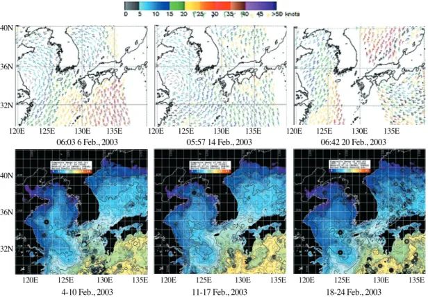
(4) Korean Journal of Remote Sensing, Vol.20, No.4, 2004. Fig. 2. Horizontal distribution of sea surface temperature (˚C) acrossing cold core eddy (32N, 123-124.3 E) in (a) May 6-11, (b) May 20-25 and (c) June 5-21, 1999.. Fig. 4. Relationship between location of cold core eddy from NOAA s infrared imagery and bottom topography in the East China Sea, February 11-17, 2003.. 냉핵 와동류 형성시 QuikSCAT위성으로 추정된 해상풍의 세기는 파랑 (5~15 Knot), 연두 (15~20 Fig. 3. Map showing the relationship between chlorophyll a on May 7th and SST derived from NOAA on May 611, 1999. Isothermal lines (15~17˚C) were overlaid on the chlorophyll a imagery derived from SeaWiFS.. Knot), 노랑 (20~25 Knot), 빨강 (25~30 Knot)으 로 표시된다. 제주도 근해역에서 북풍이 15~20 Knot로 우세하게 불고 중국의 황조만 근해역에서 북동풍이 10~15 Knot로 부는 반면, 양자강과 제주. 냉핵 와동류의 가장자리이며, 상대적으로 더운 해. 도간 중간 해역에서는 북북동(NNE)의 바람이. 역인 C(북위 32.2도, 동경 124.7도), D점(북위 31.0. 5~10 Knot로 상대적으로 약하게 불었다. 이때 에. 도, 동경 124.7도)에서는 클로로필 a 농도 분포는. 크만 수송 (Ekman transport)이 바람 방향의 오른. 4~6 mg/m3으로 다소 높게 나타났다.. 쪽으로 진행되었을 것으로 추정됨으로, 동중국해. 2003년 경우 2월 중순에 냉핵 와동류가 형성되. 북부해역의 전체적인 풍향이 중국대륙 연안에서. 는 현상을 위성 영상자료와 현장해양 관측조사 자. 확장된 냉수를 북동편과 남서편에서 차단, 포획하. 료에서 포착할 수 있었다. 냉핵 중심의 수온은. 여 냉핵 와동류가 형성되도록 북상난류의 가장자. 9~10℃ 정도였으나 주변부 수온은 11~15℃ 였다.. 리 해수를 수평 이동시켰다(Fig 5). 즉, 2003년 2월. 냉핵 와동류의 직경은 150km 정도였으며, 냉핵 와. 초순의 경우 제주도 북서쪽 근해역에서는 북서풍. 동류의 수평분포가 50m 등수심 분포와 유사하게. 이 5~10 Knot 였으며, 제주도 남쪽 150km정도 근. 나타났다(Fig. 4). –248–.
(5) Temporal and Spatial Variation of the Mesoscale Cold Core Eddy in the East China Sea Using Satellite Remote Sensing. 40N. 36N. 32N 120E. 125E. 130E. 135E. 120E. 06:03 6 Feb., 2003. 125E. 130E. 135E. 120E. 05:57 14 Feb., 2003. 125E. 130E. 135E. 06:42 20 Feb., 2003. 40N. 36N. 32N. 120E. 125E. 130E. 135E. 120E. 4-10 Feb., 2003. 125E. 130E. 11-17 Feb., 2003. 135E. 120E. 125E. 130E. 135E. 18-24 Feb., 2003. Fig. 5. Formation of cold core eddy related to the sea surface wind direction and force in February 6-20, 2003. (a) Wind direction and force derived from QuikSCAT satellite. (b) SST distribution derived from NOAA/AVHRR satellite.. 해역에서는 북풍이 10~15 Knot, 중국의 황조만 근. 일치하였다(Fig. 7a). 염분 32.0 및 33.0의 등염선도. 해역에서는 북동 또는 동풍이 5~10 Knot로 불었. 위성 수온 영상에서 나타나는 냉핵 와동류 분포. 으나, 제주도-양자강 중간 해역에서는 5 Knot 이. 위치와 일치하는 것으로 나타났다(Fig. 7b). 클로. 하의 북동풍이 불었다. 반면 2003년 2월 하순. 로필 a 수평분포는 냉핵 와동류의 온도 및 염분. (18~24일)의 경우 제주도-양자간 근해역에 20~25. 분포와 달랐다(Fig. 7c). 부유성 고형물질 (SS)의. Knot의 강한 남동풍이 불어 제주도 근해를 거쳐. 수평 농도분포는 비슷하였으며, 냉핵 와동류 중심. 황해로 유입되는 난류 주축의 첨단을 북동쪽 해역 (한국 서남해역)으로 수송시키는 작용을 한 것으 로 나타났다. 이로 인해 환형(ring) 형태로 나타났 던 냉핵 와동류의 모양이 흩트러지기 시작했다. 한편, 2003년 2월 12일에서 17일까지 국립수산과 학원의 동중국해 북부 특별 해양관측 정점(Fig. 6) 에 대한 조사가 탐구 3호로 이루어졌으며, 현장 관측 수온 분포는 위성영상에 나타난 수온 분포와 흡사하게 나타났다. 특히 수온 9℃와 10℃ 등온선 이 위성수온 분포의 냉핵 와동류의 영역과 매우. Fig. 6. Map showing oceanographic observing stations. Offshore stations (315-317 lines) for oceanographical monitoring in the northern part of the East China Sea.. –249–.
(6) Korean Journal of Remote Sensing, Vol.20, No.4, 2004. 선 위치와 34.0 연직 등염선 위치가 해표면에서 저층 바닥까지 일치하였다(Fig. 8b). 클로로필 a 연직분포는 냉핵 중심해역 (9~10℃)에서는 0.3~0.4 mg/l였으나 경계해역 (11~15℃)에서는 약 0.4~0.7 mg/l로 비교적 높게 나타났다(Fig. 8c). 부 유성 고형물질(SS)의 연직분포는 각 관측라인 (315, 316, 317)의 냉핵 중심해역에서 22~36 mg/l 로 상당히 높은 값을 나타내었으나 경계 해역에서 의 표층에서는 4~18 mg/l, 저층에서는 14~22 mg/l로 비교적 낮은 값을 보였다(Fig. 8d). 최근 Suh et al., (1999, 2000)은 북한의 원산 남 동부 근해역에서 해저 지형과 연계되어 비교적 동 일 시공간에서 안정된 변동 양상을 보이는 재발생 와동류(recurring eddy)가 공간적으로 넓게 천이되 는 시기, 즉 남하하는 북한한류와 북상하는 동한 난류 세력이 어느 해보다 강하게 만나 baroclonic 한 양상이 두드러지게 발생될 때 형성되고 변형된 시계 방향의 흐름을 가진 와동류가 외해역으로 이 탈되는 현상을 보고하였다. 이와는 달리 동중국해 에서 나타나는 냉핵 와동류는 동중국해 북부해역 이 천해의 대륙붕으로 되어있어 해저지형과 흡사 한 수평분포 양상을 보였을 뿐만 아니라 연직적으 로도 동일하게 분포하는 barotrophic한 양상을 보 였다.. Fig. 7. Distributions of measured (a) sea surface temperature (˚C), (b) sea surface salinity (psu) , (c) chlorophyll a (mg/l) and (d) suspended solid (mg/l) in February 1217, 2003.. 4. 결 론 동중국해에는 동계 및 춘계에 중규모의 냉핵 와동류가 형성 발달하는 것으로 나타났다. 이어도 를 중심으로 동계 및 춘계에 나타나는 냉핵 와동. 쪽으로 갈수록 증가하여 20 mg/l이상으로 높게 나. 류의 형성 메카니즘은 중국대륙 연안수와 쿠로시. 타났다(Fig. 7d).. 오 난류가 만나는 경계역에서 힘의 균형과 계절풍. 각 관측 라인의 연직 수온분포를 통해 볼 때,. 조건, 해저 지형 분포와 밀접한 관계성이 있는 것. 해표면에서 저층 바닥까지 냉핵 부분 해역이. 으로 사료된다. 동계 및 춘계의 동중국해 냉핵 와. 9~10℃, 가장자리 경계역 전선대가 11~15℃ 정도. 동류의 공간 스케일은 직경이 100~200 km 였고,. 에서 나타났다(Fig. 8a). 각 관측라인의 연직 염분. 시간 스케일은 2개월 정도로, 주변 해역보다 상대. 분포를 통해 볼 때, 연직 수온 10℃ 위치와 비교. 적으로 2~3℃ 낮은 수온분포를 유지하였다. 냉핵. 해보면 연직 등염선의 33.0과 일치하며, 15℃ 등온. 와동류의 존재는 해양의 표면에서만 나타나는 해. –250–.
(7) Temporal and Spatial Variation of the Mesoscale Cold Core Eddy in the East China Sea Using Satellite Remote Sensing. Fig. 8. Vertical distributions of (a) sea water temperature (˚C), (b) salinity (psu), (c) chlorophyll a (mg/m3) and (d) suspended solid (mg/l) in station lines from 315 to 317 in February, 2003.. 양 이상현상이 아니고 연직적으로도 표면 온도 분. 중국해 어장 형성 및 자원변동에 또 다른 하나의. 포에 따른 수괴의 배치 분포와 3차원적으로 일치. 중요 해양환경 요인으로 간주되며, 어족자원의 구. 한다. 냉핵 와동류의 발생과 시공간적 변동은 동. 조와 풍도에 큰 영향을 미칠 것으로 생각된다.. –251–.
(8) Korean Journal of Remote Sensing, Vol.20, No.4, 2004. SeaSpace, 1993. TeraScan Package Manual 2.4.. 사사. Shibata, A., 1983. Meander of the Kuroshio along the edge of continental shelf in the East China. 본 연구는 국립수산과학원의 「첨단 위성정보 활용시스템 운영」 , 한국항공우주연구원의 지원하. Sea, Umito Sora, 58: 113-120(in Japanese).. 에 수행한「위성자료의 해양수산 활용 연구」및. Sugimoto, T., S. Kimura, and K. Miyaji, 1988.. 한국과학재단 기초과학연구사업「RS 및 GIS를 활. Meaner of the Kuroshio front and current. 용한 한반도 주변해역의 해양환경 특성에 관한 연. variability in the East China sea, Journal of. 구」 의 일부수행 결과입니다.. Oceanographic Society Japan, 44: 125-135. Suh, Y. S., 2001. Oceanographic features around the Korean peninsula inferred from satellite remote. 참고문헌. sensing, Ph. D. Thesis, Pukyong University. (in Korean).. 국립수산진흥원, 1996~1998. 한국근해 수온분포도. Suh, Y. S., B. G. Mitchell, and K. S. Lim, 1999. A. (1991~1997).. recurring eddy off the Korean northeast. 국립수산진흥원, 1999~2002. 한국근해 해양정보. coast captured on satellite ocean color and. (1998~2001).. sea surface temperature imagery, J. Kor. Soc.. 국립수산과학원, 2003~2004. 한국근해 해양정보 (2002~2003).. Remote Sensing, 15(2): 175-181. Suh Y. S., J. H. Kim, and H. G. Kim, 2000. Relationship. 김진수, 1995. NOAA/AVHRR 자료를 이용한 황해. between sea surface temperature derived from. 남부 및 동중국해의 해표면 수온 분포 변화. NOAA satellites and Cochlodinium polycrikoides. 에 관한 연구, 서울대학교 석사학위논문.. red tide occurrence in Korean coastal waters, J.. 김희용, 조규대, 1999. 춘계 동중국해 수괴분포와. the Korean Environmental Sciences Society, 9(3):. 저서어류 분포와의 관계, 1999년도 춘계 수 산관련학회 공동학술대회 발표요약집.. 215-221(in Korean). Suh, Y. S., L. H. Jang, J. H. Kim, Y. Q. Kang, and K.. 이석우, 1983. 해양물리학통론, 집문당, 서울.. S. Lim, 2000. Study of a recurring. Lee, T. N., L. P. Atkinson, and R. Legeckis, 1981.. anticyclonic eddy off Wonsan coast in. Observations of a Gulf Stream frontal eddy. northern Korea using satellite tracking. on the Georgia continental shelf, April 1977,. drifter, satellite ocean color and sea surface. Deep-Sea Research, 28A: 347-378.. temperature imagery, J. Kor. Soc. Remote Sensing, 16(3): 211-220(in Korean).. Pang, I. C., K. H. Oh, and H. K. Rho, 1997. Influence of the circulation in the East China Sea on. Suh Y. S., L. H. Jang, N. K. Lee, and B. K. Kim,. the volume transport in the Korea Strait, The. 2002. Development of the regional algorithms. East China Sea (Proceeding of the 1st. to quantify chlorophyll a and suspended. international workshop on the Oceanography. solid in the Korean waters using ocean color,. and Fishery in the East China Sea), 1: 26-39.. J. Korean Fish Society, 35(3): 207-215(in Korean).. Qiu, B., T. Toda, and N. Imasato, 1990. On Kuroshio. Yanagi, T., T. Shimizu, and H. J. Lie, 1998. Detailed. front fluctuations in the East china Sea using. structure of the Kuroshio frontal eddy along. satellite and in situ observational data, Journal. the shelf edge of the East China Sea,. of geophysical research, 95(C10): 18,191-18,204.. Continental Shelf Research, 18: 1039-1056.. –252–.
(9)
수치


관련 문서
Combined oceanic current maps in the seas around Korean peninsula (the East Sea, the Yellow Sea, the East China Sea, the Northwest Pacific Ocean) for (a) warm currents and
Sixteen major items, such as the flow of the Kuroshio Current into the East China Sea and its northward path, the origin of the Tsushima Warm Current and its path into
Abstract : A sandstone body of the Chinook Member in the Puskwaskau Formation of the Smoky Group in west-central Alberta was investigated using available core and well log data
ABSTRACT: We analyzed 2-D seismic and well-log data from the southern Jeju Basin, offshore southern Korea, northern East China Sea to estimate the CO2 storage capacity of the
The images of suspended solid particle 3 distribution range: over 10 g/m obtained from SeaWiFS using Ahn's SS algorithm at the East China Sea in April every year from 1998 to
East of the Ben- tong-Raub suture in the Central Belt of Peninsular Malaysia, the development of the Semantan Formation, similar to the Lampang facies in Northern
During formation and development of the Earth's crust of the Far East territory which a num- ber of basic geostructures were formed, the scale and occurrence of ore of each
and Ryu, B.-J., 2003a, Stratigraphy of late Quaternary core sediments and comparative study of the tephra layers from the northwestern Ulleung Basin of the East Sea. and Ryu,
