IEG 환경지질연구정보센터
11
0
0
전체 글
(2) A Morphological Evolution of the Chinook Member in West-Central Alberta, Canada 17. Fig. 1. Map of the Western Canadian Sedimentary Basin (WCSB) showing the two major sub-basins. The Alberta Basin is located in the west of the WCSB across the border between Alberta and British Columbia in Canada, whereas the Williston Basins lies in the southeastern margin of the WCSB.. Fig. 2. Stratigraphic chart of the Upper Cretaceous in the northwest of the Alberta Basin. Yellow colored members are proven productive reservoirs and the Chinook Member in the Puskwaskau Formation is the uppermost sandstone of the Smoky Group. The number in the middle column represents geological age in Ma..
(3) 18. Juhee Kang · Myong-Ho Park · Min-Jun Kim. has been poorly described and mapped (e.g., Gleddie, 1949; Stott, 1967; Leckie, 1992; Leckie et al., 1994; Smith, 1994), partly because it may be comparable and/or broadly equivalent to the Chungo Member (and, thus, of similar facies) (e.g., Varban and Plint, 2005; Hu and Plint, 2009) in west-central Alberta. Many workers show that the shoreface sandstone of the Chungo Member is slightly older than that of the Chinook Member (e.g., Stott, 1975; Varban and Plint, 2005; Hu and Plint, 2009). These studies also suggest that the Chinook sandstone forms a clastic wedge in a linear shoreface developed on the shelf (e.g., Smith, 1994). Linear sandstones of the Cretaceous Western Seaway have been deposited in shelf ridges or offshore bars mostly isolated from paleoshorelines by muddy shelf sediments (Berg, 1975; Tillman and Siemers, 1984). These linear sandstones deposited on the shelf during the lowstand, which was covered by following transgressive mudstone (Bergman and Walker, 1987; Pattison and Walker, 1992; Posamentier and Vail, 1988). However, the elongate shoreface sandstones could can be preserved only if extensive erosion over shorelines occurred during the slow transgression or casual stillstand (Chen and Bergman, 1999). The linear feature of the sandbodies may also be related to tectonic movements (i.e., faulting, uplift, or subsidence) (Stockmal et al., 1992). The Alberta Basin along the Rocky Mountain Foothills is characterized by regionally distributed marine mudstones interrupted by the shallow-marine sandstones of the Smoky Group (Stott, 1967; Chen and Bergman, 1999) (Fig. 2). Some of the sandstones (e.g., Cardium Member) show eastward-thinning narrow, linear sand bodies with a NW-SE trend, thinning out toward the east. Closely resembling the Chungo sandstone, the Chinook Member is also composed of a NW-SE trending elongate coarsening-upward unit covered by ravinement surface with pebbly conglomerate prior to the subsequent transgressive mudstone (the Nomad Member) (Hu and Plint, 2009). The objective of the present study is to investigate the geomorphological evolution of the Chinook Member in the Puskwaskau Formation of the Smoky Group in the Alberta Basin. The depositional model is reconstructed based on stratigraphic correlation of well-logs integrated with core data, assuming the Chinook Member is equivalent to the Chungo sandstone in the study area (sensu Hu and Plint, 2009). The stratigraphic unit nomenclature of the Smoky Group adopted in the present work conforms to the scheme proposed in previous studies (e.g., Stott, 1967 and 1984; Payenberg et al., 2002; Nielsen et al., 2003; Stockmal, 2004) to describe and interpret the Chinook sandstone interval.. GEOLOGICAL SETTING The WCSB is composed of two major sedimentary basins: the Alberta and Williston Basins (Wright et al., 1994) (Fig. 1). The Williston basin was formed by an intracratonic structural depression, whereas the Alberta Basin was a northwest-trending foreland basin (Wright et al., 1994). The. foreland basin mainly developed in the Middle to Late Jurassic after the Omineca belt was deformed and metamorphosed forming a northeast facing fold-and-thrust belt (Price, 1973; Monger et al., 1982; Stott, 1984; Cant and Stockmal, 1989). As the horizontal compression and translation were continuously exerted onto the platform rocks, the deformed Omineca belt was uplifted in the Late Oxfordian, forming stacked thrust sheets (i.e., the Rocky Mountain foldand-thrust belt) in western North America (Leckie and Smith, 1992). The tectonically significant crustal thickening and eastward overthrusting of the cratonic strata during the Jurassic and Cretaceous pushed the underlying crustal block down (i.e., isostatic flexture) forming a NW-SE oriented crescent-shaped, retro-arc foreland basin (Price, 1973). The NW-SE elongate foreland basin was filled with syntectonic deposits of a fluvial to shallow-marine succession shed eastward from the fold-and-thrust belt of the Paleozoic and older Mesozoic sedimentary rocks to the east during the Middle Jurassic to early Tertiary (van der Pluijm et al., 2006; Smith, 1994). During the Late Cretaceous, significant amounts of sediments were derived from the active fold and thrust belt in the northeastern part of the Alberta Basin, forming shoreline into the basin at a direction almost parallel to the fold and thrust belt (Smith, 1994). The Upper Cretaceous Smoky Group is composed of, from older to younger, the Kaskapau, Cardium, Muskiki, Puskwaskau, and Wapiti Formations in ascending order exposed in northern Athabasca River (Hu and Plint, 2009). The Puskwaskau Formation comprises five members; these are, in order of age, from the base to the top: the Dowling, Thistle, Hanson, Chungo, and Nomad members (Hu and Plint, 2009). The former four members indicate change from transgression to regression (from Conician to Campanian) and the uppermost unit (the Nomad Member) represents a marine transgression in top of the Late Cretaceous succession. The Chungo Member is the only sandstone unit whereas the rest are dominantly mudstones and thus the sandstone unit appears to be enveloped by the mudstone members. The Chinook MJember (referred to as L in Hu and Plint, 2009) consists primarily of swaley and/or hummocky crossstratified sandstone bodies, both in outcrops and the subsurface, showing a coarsening-upward succession indicative of deposition in a storm-dominated, open-marine, offshore to shoreface environment during a transgression in the western part of the Alberta Basin (Hu and Plint, 2009). The upper part of the shallow-water deposits was cut by a pebbleveneered erosional surface toward the northeast that is onlapped by mudstone (referred to as M in Hu and Plint, 2009), suggesting a substantial relative sea-level fall that forced the paleoshoreline out across the shelf. The base of the Chungo progressively truncates the underlying stratigraphic unit from the southeast toward the northwest possibly due to a gradual tilting and tectonic uplift in the northwest either before or during deposition of the shallow-marine sediments (Hu and Plint, 2009). The maximum regressive and subsequent transgressive deposits, occurred in the Late Campanian,.
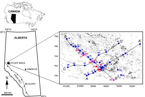
(4) A Morphological Evolution of the Chinook Member in West-Central Alberta, Canada 19. overlying the shoreface sediments (Leckie and Smith, 1992).. STUDY AREA, DATABASE, AND METHODS The study area is situated between Townships 60 and 68, and Ranges 1 to 12, W6M to the Rocky Mountain Foothills in the WCSB (Fig. 3). It encompasses approximately 12,350 km2 and there are 184 well logs (gamma ray and resistivity curves) for this area. The well logs were used to analyze the subsurface stratigraphy for stratigraphic surface correlation within the study area. They also were used to construct structure contour maps of between the Chinook and Nomad members contact as well as detailed isopach maps of the Chinook Member. The present study shows three representative cross-sections: one is a strike (NW-SE) and the other two are dip (SW-NE) correlation lines, and all of them utilize the basal surface of the Wapiti Formation as a datum. The strike and dip correlation sections are about 98 km and 180 km long, respectively (an elongate body). All available sedimentary cores in the study area were examined to provide sedimentologic information (including cements). The selected unweathered intervals were logged based on lithology, bedding contact, sedimentary structure, and fossil contents. The well logs were calibrated with netto-gross sandstone values determined from the core measurements to develop reliable composite sections. The 75 API gamma radiation line was used as the sandstone cutoff in the present study.. For determining reservoir characteristion a suite of samples was collected from each sandstone interval to manufacture thin sections that were then encapsulated and impregnated with epoxy-based resin to identify porosity and preserve textures. Core descriptions, thin section observations, and log signatures were all compared to the petrophysical properties of the rocks (i.e., porosity and permeability measurements) derived from standard core analysis of plugs and full diameter samples to determine the reservoir quality of the sandstone.. SANDSTONE LITHOFACIES The Chinook sandstone in the study area consists of five primary lithofacies on the basis of textural trends, lithology, fossil content (i.e., ichnofacies) and sedimentary structures (Fig. 4). These lithofacies are dark gray mudstone and siltstone (LF-1), bioturbated very fine to fine sandstone alternated with thin mudstone (LF-2), sedimentary structures such as swaley and hummocky cross-stratified fine sandstone (LF-3), fine to medium grained sandstone with ripples (LF4), and matrix-supported granular conglomerate (LF-5). Dark gray mudstone and siltstone (LF-1) Description The lowermost depositional unit is topped by a sharp surface; however, it appears to be much thicker as indicated by the low-value log signatures. This facies consists of homogeneous thin-bedded silty mudstone whose sedimentary. Fig. 3. Location map of the study area in the northwest of the Alberta Basin containing the locations of well logs selected for lithostratigraphic correlations. Dots in the study area represent locations of drilling. Red closed circle indicates the sites where cores were sampled..
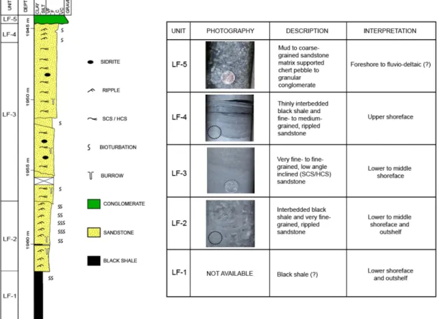
(5) 20. Juhee Kang · Myong-Ho Park · Min-Jun Kim. Fig. 4. A stratigraphic log based on the core descriptions of 11-07-63-05W6 (left panel) and the details of the lithostratigraphic units identified (right panel). The scale of the LF-4 and the LF-2 on the core photos is indicated by a dashed black circle, which is the same size as the coins on the others. See Fig. 2 for the well location.. structures are partially obscured by bioturbation. The trace fossils include Skolithos, Planolites, Asterosoma, and Zoophycus. Interpretation The LF-1 displays characteristics suggesting a low-energy depositional environment (i.e., an open shelf) where mudstones accumulated during a sea level rise. The mudstone mostly represents deposition in deeper water with either restricted sand supply or lower energy during deposition. In westcentral Alberta, the sand-poor mudstone is likely to correspond to the distal part (i.e., shelf) of the Hanson Member in the Puskwaskau Formation, and the mudstone-dominated lithofacies also seems to be broadly consistent with the lithostratigraphic units referred to as the I, J, and K allomembers in Hu and Plint (2009). Bioturbated very fine to fine sandstone altered with thin mudstone (LF-2) Description The LF-2 consists of heavily bioturbated very fine to fine sandstones with minor shale and silty shale. It disconformably overlies basinal mudstone (LF-1) that is easily recognized as it is marked in vertical section by erosion, abrupt increases. in grain size, and sand content. This unit consists of a slightly coarsening-upward section but its sedimentary structures are heavily disrupted and obscured by bioturbation. The primary sedimentary structures are ripple lamination and wavy/lenticular lamination. There are occasional sand-size pyrite nodules. The LF-2 include abundant trace fossils such as Skolithos, Planolites, Chondrites, Ophiomorpha, Teichichnus, Thalassinoides, Cylindrichnus, Asterosoma, and Zoophycus. The diversity of trace fossils in this facies is in highest. Interpretation The LF-2 is interpreted to represent deposition on transition from lower shoreface to inner-shelf. The sharp and erosive lower boundary indicates a sudden deposition of the sandstone. The wave ripples are indicative of wave influence and thus, wave-dominated shoreface. The pyrite nodules in the core probably formed shortly after deposition (diagenetic), indicating anoxic conditions due to consumption of available oxygen by aerobic bacteria in the lower shoreface. The highly diverse trace fossil content suggests a shallow sublittoral environment below the fair-weather-wave base; however, the presence of Skolithos ichnofacies in the bioturbated silty sandstone suggests an occasional, very weak, shallow-marine influence..
(6) A Morphological Evolution of the Chinook Member in West-Central Alberta, Canada 21. Swaley and hummocky cross-stratified fine sandstone (LF3) Description The LF-3 achieves a maximum thickness of 15 m, and consists of a slightly coarsening-upward succession of whitishgrey, very fine to fine and relatively well sorted sandstone. Sedimentary structures include swaley and hummocky crossstratification, planar tabular cross-stratification, or subhorizontal lamination. Gutter casts exist sparsely at the base of the LF-3. The gutter casts associated with some of the discontinuities record scouring into a partly lithified substrate (MacEachern et al., 1992) that may have been exhumed by erosion at the discontinuity surface. A few intervals of this facies are burrowed. The SCS/HCS is common sedimentary structure, while tabular and low-angle laminations are minor components. Trace fossils are rare to moderate but occur throughout the facies. The trace fossils include Skolithos, Planolites, and Chondrites.. show coarsening upward, from very fine to fine grained sandstone, and an upward-shallowing transition from the SCS/HCS to undulatory subparallel lamination. Matrix-supported granular conglomerates (LF-5) Description The LF-5 consists predominantly of fine grained matrixsupported conglomerates mainly composed of black and light-gray or white rounded chert pebbles mixed with mudstone. The chert pebbles are up to 2 cm in diameter and are admixed with clay and silt, which constitute about 35% of the total particles in this facies. The pebble clasts in the conglomeratic bed are not imbricate. Conglomerate layers and beds attain a maximum thickness of greater than 3 m and these commonly occur above the LF-4 in the study area. The top of the LF-5 is an erosive surface and is overlain by much thicker marine shale. This facies is unburrowed to sparsely bioturbated and contains no fossils (Fig. 5).. Interpretation The LF-3 represents middle to upper shoreface deposits between the fair-weather and storm wave base on the basis of upward increase in grain size and in-flow strength indicated by the sedimentary structures, and the presence of SCS/HCS bedding. The SCS/HCS structures represent stormgenerated wave structures that are commonly identified in upper shoreface (Dot and Bourgeois, 1982; Leckie and Walker, 1982). The tabular and subhorizontal laminations may have formed by wave-induced longshore currents in the middle shoreface, reflecting high-energy, fair-weather-wave processes in a shallow, near-shore environment (Hunter et al., 1979; Howard and Reineck, 1981). Fine to medium sandstone with ripple (LF-4) Description This facies consists of bright-grey, well-sorted fine to medium sandstone interbedded with black shale. It is somewhat similar in grain size and sedimentary structure to the LF-3. It shows low-angle horizontal stratification, occasional wave-ripples, and wavy/lenticular laminations. The wavy/ lenticular beds are locally burrowed. Siderite and pyrite are dispersed commonly associated with the shale. The sandstone is well cemented with calcite. Trace fossils are rare in this facies and occur as isolated appearances of Skolithos, Planolites, Teichichnus, and Cylindrichnus. Interpretation The LF-4 is interpreted to have been deposited in a relatively shallower energy setting as compared with the LF3. The presence of wave-ripple cross-stratification, undulatory subparallel lamination, and minor bioturbation in the LF-4 may represent a subaqueous deposition in a wave-dominated shoreface environment above the fair-weather wave base. The wave-ripple lamina intervals are a common feature in the upper part of the storm beds and may indicate fairweather wave reworking. Therefore, the LF-3 and LF-4. Fig. 5. Trace-fossil distributions in cores of the Chinook Member. 1 = Asterosoma; 2 = Zoophycus; 3 = Cylindrichnus; 4 = Thalassinoides; 5 = Teichichnus; 6 = Ophiomorpha; 7 = Chondrites; 8 = Planolites; 9 = Skolithos. Red and blue colors indicate occasional and sparse occurrences, respectively..
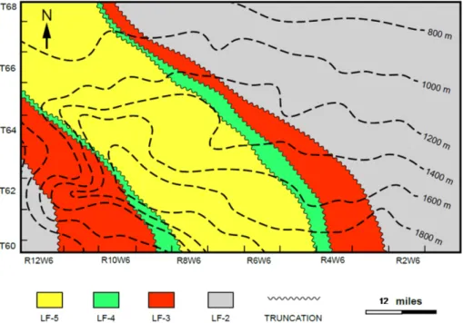
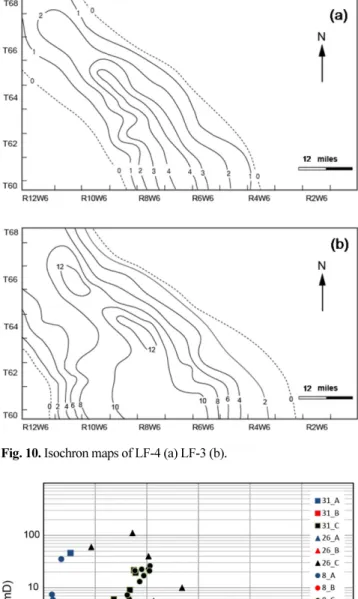
(7) 22. Juhee Kang · Myong-Ho Park · Min-Jun Kim. Interpretation The LF-5 is interpreted to represent transgressive lag conglomerates with shales deposited proximal to foreshoreshoreface settings (i.e., Krause and Nelson, 1991). Reworking of ridge sediments occurred by more infrequent, very high energy events (and, thus, conglomeratic facies) as the water deepened (i.e., transgression) and sedimentation switched to deposition of clay and silt-sized materials. Deposition during this transgressive event may have returned the area to an accumulation pattern characterized by the development of extensive mud banks in the near-shore zone. The LF-5 could also be indicative of a local influx of muddy, conglomerateladen density currents as a result of reworking by stormgenerated combined wave current flows. Since graded conglomerate beds were not found at the ridge top, and instead abundant beds with layered shaly conglomerates were observed, it is presently believed that the conglomerates of the LF-5 represent hydrodynamically reworked and sorted ridge sediments amalgamated with shales and silts.. RESERVOIR STRUCTURE, ARCHITECTURE, AND EVOLUTION Reservoir Structure The structural contour map in Fig. 6 is based on the erosion surface picked from geophysical logs, reflecting subsea elevation of the top of the Chinook conglomerate. The erosion surface intersects the two walls of the valley, forming a V-shape in the trace on the map, and the valley floor runs toward the southeast. The valley wall closer to the foothills appears to be more deformed than that of the other wall, suggesting that the southwestern part of the study area. was more vulnerable to structural deformation (e.g., shortening) than the other side. However, consistent with previous studies (e.g., Chen and Bergman, 1999; Varban and Plint, 2005; Hu and Plint, 2009), no fault was identified in the study area. The Chinook sand body lies within the west-central section along the deformation front of the foothills of Alberta. The southeast dip of the structure may be relevant to the migration of hydrocarbons. Reservoir Architecture The well log cross-sections show the lateral extent of the lithofacies and their relationships to the Chinook sandstone reservoir along both dip (Figs. 7 and 8) and strike (Fig. 9). The SW-NE lithofacies cross-sections also illustrate that the well log markers (tops of the LF-5 to LF-3) are truncated by the lower surface of the overlying unit (Nomad Member) and these display positive relief with a relatively steep eastern slope and a gentler western slope (Figs. 7 and 8). In contrast, the NW-SE lithofacies cross-section shows relatively uniformly accumulated units of the Chinook Member (Fig. 9). The LF-4 and the LF-3 isopach maps (Fig. 10) show the total thickness of the reservoir interval of the Chinook Member, the main focus of the present study because of their reservoir quality (Fig. 11). The thickness trend of the reservoir indicates that the Chinook Member represents a narrow, NW-SE (azimuth 138 degrees, Fig. 10) trending elongated sand body whose thickest area lies in the north of the study area. The sand body is approximately 15 km in length and has an average width of 12 km (and thus a length to width ratio of 1.25 to 1). The isopach maps display positive relief with a relatively steep eastern slope and a gentle. Fig. 6. Structural contour map of the Chinook Member on top of the LF-5 indicated by the dashed line. NW-SE elongate sand body is truncated on both the western and eastern sides. Contour interval is 200 m..
(8) A Morphological Evolution of the Chinook Member in West-Central Alberta, Canada 23. Fig. 7. Cross-section in the dip direction showing the lithostratigraphy and relationships of the Chinook sandstone lithofacies named LF-1 to LF-5, from bottom to top. The top of the LF-5 is truncated throughout the interpreted section. See Fig. 2 for location.. Fig. 8. Cross-section in the dip direction showing the lithostratigraphy and relationships of the Chinook sandstone lithofacies named LF-1 to LF-5, from bottom to top. The top of the LF-5 is truncated throughout the interpreted section. See Fig. 2 for location.. Fig. 9. Cross-section in the strike direction showing the lithostratigraphy and relationships of the Chinook sandstone lithofacies named LF-1 to LF5, from bottom to top. The top of the LF-5 is truncated throughout the interpreted section. See Fig. 2 for location..
(9) 24. Juhee Kang · Myong-Ho Park · Min-Jun Kim. advanced seaward during the early Campanian (Late Cretaceous), while the shoreline along the foothills in westcentral Alberta prograded eastward as the relative sea-level fell rapidly (i.e., forced regression). The shoreline sands are assumed to have been provided by rivers located in the northern area. During subsequent stillstands in the deepening period in the study area (relative sea-level rise), the shoreface sand body influenced by storms was incised and reworked probably by wave-generated currents on both sides; however, the alongshore drift was more likely to be affected the western side of the sand body than the eastern side. In this fashion, the shoreface sand body formed a NW-SE orienting, asymmetrical geometry isolated from the fluvial or coastal environment. The sand body was still under reworking by storm-generated combined wave-current flows that might have brought an influx of local muddy conglomerate-laden density currents that rested on the LF-4 (Krause and Nelson, 1991). The conglomerate-topped shoreface sand body was completely buried and capped by shales deposited during the following transgression in the Late Campanian.. DISCUSSION AND CONCLUSIONS. Fig. 10. Isochron maps of LF-4 (a) LF-3 (b).. Fig. 11. Porosity-permeability relationships for three core data indicated by 8, 26, and 31. A = LF-5; B = LF-4; C = LF-3. Note that LF-3 shows better reservoir quality than the others. See Fig. 2 for their locations.. western slope, forming an asymmetrical lenticular geometry. This formation could be the result of reworking processes in a shallow water setting (Pattison and Walker, 1991). Morphological Evolution of the Reservoir Prior to the deformation, a parasequence built out or. Although producing hydrocarbon since the late 1980s, the Chinook sandstone reservoir has received little attention from the oil industry probably because of its size and associated trapping capacity. The present study examined the available core samples and well logs of west-central Alberta to delineate the geometry of the sandstone reservoir and to investigate the geological evolution of the Chinook Member. This study divided the single parasequence into five different lithofacies (LF1 to LF5) based on core data analysis. The core data show that the Chinook Member is a typical coarsening-upward, shallow-marine sediment significantly influenced by storms. The shallow marine sandstone is bounded by thick shales at its base and top, forming a single shoreface parasequence (Walker, 1980). In cross-sections, the top lithofacies (the LF-5) is truncated by an erosion surface and the isochron maps of the reservoir intervals (LF4 and LF-3) indicate an elongate NW-SE trending asymmetric geometry for the sand body. This lenticular architecture has previously been interpreted as a shelf ridge (Berg, 1975; Hobson et al., 1982; Tillman and Martinsen, 1984; Krause and Nelson, 1991), an offshore bar (Berven, 1966; Plint, 1988), and an incised shoreface sandstone (Pattison and Walker, 1992). The shelf ridge and offshore bar interpretations still need to explain how the sediments were transported across the shelf and concentrated to form the long, narrow geometry. However, it is more plausible that the incised conglomerate topped sand body formed by shallow marine processes (e.g., alongshore drift, wave-induced reworking, and storm-generated currents). The present study combines the mechanisms proposed by Krause and Nelson (1991) and Pattison and Walker (1992) to interpret the Chinook Member in west-central Alberta. A prograding parasequence advancing basinward during the.
(10) A Morphological Evolution of the Chinook Member in West-Central Alberta, Canada 25. Early Campanian in the Late Cretaceous is assumed. The shoreline sands of the parasequence along the foothills were provided from the northern rivers and they moved eastward during a rapid relative sea-level fall. Subsequent stillstands in the deepening period in the study area (relative sea-level rise) allowed the shoreface sand body to be vulnerable to storms, resulting in incising and reworking on both sides of the sand deposits; however, the alongshore drift more likely affected the western side of the sand body more than the eastern side. In this fashion, the shoreface sand body formed a NW-SE orienting, asymmetrical geometry. With the stormgenerated combined wave-current flows still influencing the study area, there were local influxes of muddy conglomerateladen density currents. The conglomerate topped shoreface sand body was completely buried and encased by shales deposited during the following transgression in the Late Campanian.. ACKNOWLEDGEMENTS This work was supported by Ministry of Oceans and Fisheries for the project “Construction of carbon storage map and selection of demonstration sites in Korean offshore areas” (20052004) and also by Ministry of Trade, Industry and Energy for the project “Small-scale CO2 injection-demonstration project in offshore Pohang Basin” (20132010201760).. REFERENCES Berg, R.R., 1975, Depositional environment of Upper Cretaceous Sussex Sandstone, House Creek field, Wyoming. American Association of Petroleum Geologists, Bulletin, 59, 2099-2110. Beroman, K.M. and Walker, R.G., 1987, The importance of sea-level fluctuations in the formation of linear conglomerate bodies: Carrot Creek Member, Cretaceous Western Interior Seaway, Alberta, Canada. Journal of Sedimentary Petrology, 57, 651-665. Cant, D.J. and Stockmal, G.S., 1989, The Alberta foreland basin: relationship between stratigraphy and Cordilleran terrane-accretion events. Canadian Journal of Earth Sciences, 26, 1964-1975. Chen, D. and Bergman, K.M., 1999, Stratal reorientation, depositional processes, and sequence evolution of the Cretaceous in the Peace River Arch region of the Western Canada Sedimentary Basin. Bulletin of Canadian Petroleum Geology, 47, 594-620. Dott, R.H., Jr. and Bourgeois, J., 1982, Hummocky stratification: significance of its variable bedding sequences. Geological Society of America, Bulletin, 93, 663-680. Gleddie, J., 1949, Upper Cretaceous in Western Peace River Plains, Alberta. American Association of Petroleum Geologists, Bulletin, 33, 511-532. Howard, J.D. and Reineck, H.E., 1981, Depositional facies of highenergy beach-to-offshore sequence: Comparison with low-energy sequence. American Association of Petroleum Geologists, Bulletin, 65, 807-830. Hu, Y.G. and Plint, A.G., 2009, An allostratigraphic correlation of a mudstone-dominated, syn-tectonic wedge: the Puskwaskau Formation (Santonian-Campanian) in outcrop and subsurface, Western Canada Foreland Basin. Bulletin of Canadian Petroleum Geology, 57, 1-33.. Hunter, R.E., Clifton, H.F. and Phillips, R.L., 1979, Depositional processes, sedimentary structures, and predicted vertical sequences in barred nearshore systems, southern Oregon coast, Journal of Sedimentary Petrology, 49, 411-726. Krause, F.F. and Nelson, D.A., 1991, Evolution of an Upper Cretaceous (Turonian) shelf sandstone ridge: analysis of the CrossfieldCardium pool, Alberta, Canada. In: Swift, D. J. P., Oertel, G. F., Tillman, R. W., and Thorne, J. A. (eds.), Shelf Sand and Sandstone Bodies: Geometry, Facies and Sequence Stratigraphy, International Association of Sedimentologists, Special Publication, 14, 427-456. Leckie, D.A. and Smith, D.G., 1992. Regional setting, evolution, and depositional cycles of the Western Canada Foreland Basin. In: Macqueen, R.W. and Leckie, D.A. (eds.), Foreland Basins and Fold Belts, American Association of Petroleum Geologists, Memoir, 55, 9-46. Leckie, D.A., Bhattacharya, J.P., Bloch, J., Gilboy, C.F., and Norris, B., 1994, Cretaceous Colorado/Alberta Group of the Western Canada Sedimentary Basin. The Geological Atlas of the Western Canada Sedimentary Basin, Canadian Society of Petroleum Geologists and Alberta Research Council, Calgary, p. 335-352. MacEachern, J.A., Zaitlin, B.A. and Pemberton, S.G., 1992, A Sharpbased Sandstone of the Viking Formatiom, Joffre Field, Alberta, Canada: Criteria for Recognition of Transgressively Incised Shoreface Complexes. Journal of Sedimentary Research, 69, 876892. Masters, J.A., 1979, Deep Basin gas trap, western Canada: American Association of Petroleum Geologists, 63, 152-181. Monger, J.W.H., Price, R.A. and Tempelman-Kluit, D.J., 1982, Tectonic accretion and the origin of the two major metamorphic and plutonic welts in the Canadian Cordillera. Geology, 10, 70-75. Nielsen, K.S., Schröder-Adams, C.J., Leckie, D.A., Haggart, J.W. and Elberdak, K., 2008, Turonian to Santonian paleoenvironmental changes in the Cretaceous Western Interior Sea: The Carlile and Niobrara formations in southern Alberta and southwestern Saskatchewan, Canada. Palaeogeography Palaeoclimatology Palaeoecology, 270, 64-91. Pattison, S.A.J. and Walker, R.G., 1992, Deposition and interpretation of long, narrow sand bodies underlain by a basinwide erosion surface: Cardium Formation, Cretaceous Western Interior Seaway, Alberta, Canada. Journal of Sedimentary Petrology, 62, 292-309. Payenberg, T.H.D. and Braman, D.R., 2003, Depositional environments and stratigraphic architecture of the Late Cretaceous Milk River and Eagle formations, southern Alberta and north-central Montana: relationships to shallow biogenic gas. Bulletin of Canadian Petroleum Geology, 51, 155-176. Posamentier, H.W. and Vail, P.P., 1988, Eustatic controls on clastic deposition II - sequence and systems tract models. In: Wilgus, C.K., Hastings, B.S., Kendall, C.G.St.C., Posamentier, H.W., Ross, C.A., and Van Wagoner, J. (eds.), Society of Economic Paleontologists and Mineralogists, Special Publication, 42, 125154. Price, R.A., 1973, Large-scale gravitational flow of supracrustal rocks, southern Canadian Rockies. In: De Jong, K.A. and Scholten, R. (eds.), Gravity and Tectonics, New York, John Wiley and Sons, p. 491-502. Price, R.A., 1994, Cordilleran tectonics and the evolution of the Western Canada Sedimentary Basin. In: Mossop, G.D. and Shetsen, I. (eds.), The Geological Atlas of the Western Canada Sedimentary Basin, Canadian Society of Petroleum Geologists and.
(11) 26. Juhee Kang · Myong-Ho Park · Min-Jun Kim. Alberta Research Council, Calgary, p. 13-24. Smith, D.G., 1994, Paleogeographic evolution of the Western Canada Foreland Basin. Mossop, G.D. and Shetsen, I. (eds.), The Geological Atlas of the Western Canada Sedimentary Basin, Canadian Society of Petroleum Geologists and Alberta Research Council, Calgary, p. 277-295. Stockmal, G.S., Cant, D.J. and Bell, J.S., 1992, Relationship of the stratigraphy of the Western Canada Foreland Basin to Cordilleran tectonics: Insights from geodynamic models. In: Macqueen, R.W. and Leckie, D.A. (eds.), Foreland Basins and Fold Belts. American Association of Petroleum Geologists, Memoir, 55, 107-124. Stockmal, G.S., 2004, A pop-up structure exposed in the outer foothills, Crowsnest Pass area, Alberta. Bulletin of Canadian Petroleum Geology, 52, 139-155. Stott, D.F., 1967, The Cretaceous Smoky Group, Rocky Mountain Foothills, Alberta and British Columbia. Geological Survey of Canada, Bulletin, 132, 133 p. Stott, D.F., 1982, Lower Cretaceous Fort St. John Group and Upper Cretaceous Dunvegan Formation of the foothills and plains of Alberta, British Columbia, district of Mackenzie and Yukon Territory. Geological Survey of Canada, Bulletin, 328, 124 p.. Tillman, R.W., and Siemers, C.T., 1984, Siliciclastic shelf sediments: Society of Economic Paleontologists and Mineralogists, Special Publication, 34, 268 p. Van der Pluijm, B.A., Vrolijk, P.J., Pevear, D.R., Hall, C.M. and Solum, J., 2006, Fault dating in the Canadian Rocky Mountains: Evidence for late Cretaceous and early Eocene orogenic pulses, Geology, 34, 837-840. Varban, B.L. and Plint, A.G., 2005, Allostratigraphy of the Kaskapau Formation (Cenomanian-Turonian) in subsurface and outcrop: NE British Columbia and NW Alberta, Western Canada Foreland Basin. Bulletin of Canadian Petroleum Geology, 53, 357-389. Wright, G.N., McMechan, M.E., and Potter, D.E.G., 1994, Structure and Architecture of the Western Canada Sedimentary Basin. In: Mossop, G.D. and Shetsen, I. (eds.), The Geological Atlas of the Western Canada Sedimentary Basin, Canadian Society of Petroleum Geologists and Alberta Research Council, Calgary, p. 25-40.. (2015. 3. 5. 원고접수) (2015. 3. 30. 수정본채택).
(12)
수치


+4

관련 문서
The “Asset Allocation” portfolio assumes the following weights: 25% in the S&P 500, 10% in the Russell 2000, 15% in the MSCI EAFE, 5% in the MSCI EME, 25% in the
:: read the data sent and copies it to the realy log..
1 John Owen, Justification by Faith Alone, in The Works of John Owen, ed. John Bolt, trans. Scott Clark, "Do This and Live: Christ's Active Obedience as the
The study was made to reduce the weight of the body by using Friction Stir Welding (FSW), which is a solid joining process of low heat input type in order to solve
The anaerobic metabolic ability of the lower body was measured by a wingate test using a bicycle ergometer. The upper body anoxic metabolic ability was
In addition, Wallace and Froum 20) reported that the bone formation rate was superior in the cases using a barrier membrane in comparison with the
A and E, In control group, a small amount of new bone was observed at the margin of bone defect (40×); B and F, In experimental group 1, a large amount of new bone was formed
There was a significant increase in new bone formation in the group in which toothash and plaster of Paris and either PRP or fibrin sealants were used, compared with the groups
