• 검색 결과가 없습니다.

IEG 환경지질연구정보센터

N/A
N/A
Protected

Academic year: 2021

Share "IEG 환경지질연구정보센터"

Copied!
5
0
0

로드 중.... (전체 텍스트 보기)

전체 글

(1)

1. Introduction

The circulation of the Japan/East Sea (JES) is characterized by significant temporal and spatial variability due to such factors as seasonal fluctuations in the warm inflow through Tsushima Strait, branching of the Tsushima Warm Current (TWC), and the formation of mesoscale eddies along these branches. Thermal contrasts are usually associated with the warm and cold currents, eddies and upwelling. Indented coastal line and sharp slope of shelf rising from the Ulleung Basin at 1000-2000 m

up to 50 m just 20-50 km off the coast are also contribute to complicated water dynamics. Interaction of currents with underwater relief and islands generates fronts, vortices and internal waves.

Although the main features of the JES circulation are reasonably well known, a detailed description of even dominant currents like the Tsushima Warm Current (TWC), East Korean Warm Current (EKWC), etc.

still eludes oceanographers. They are constantly changing and must be measured repeatedly to estimate their mean flux.

While the sampling capabilities of visible and

ERS SAR Observations of the Korean Coastal Waters

Hong-Joo Yoon

*, Leonid M. Mitnik**, Heung-Soon Kang*, and Han-Keun Cho*

* Pukyong National University

** V.I. Il’ichev Pacific Oceanological Institute FEB RAS, Russia

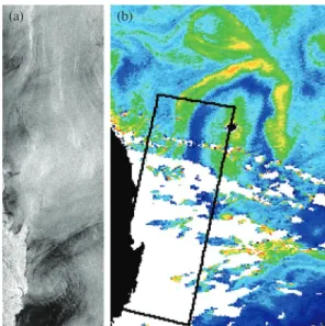
Abstract : The processes of regional scales in the East Korean coastal waters were investigated by analysis of the Synthetic Aperture Radar (SAR) images taken by the European Research Satellites ERS-1, ERS-2 and Envisat. More than 500 quick look frames taken in 1991-2003 were examined to detect the frames with clearly surface expressions of oceanic phenomena. 26 ERS-1/2 SAR and 11 Envisat wide swath Advanced SAR (ASAR) frames were selected and obtained from the European Space Agency in a form of the precision high-resolution images. The following oceanic phenomena and processes were evident in the radar imagery through the Korean costal waters: fronts, currents, eddies, internal waves, island and ship wakes, oil pollution, etc. They manifested themselves in the field of sea surface roughness, their scale ranged from several tens meters to about 100 km. The most common morphology of these phenomena was a series of contrast dark or light curvilinear lines and bands. The joint analysis of the discussed SAR images with other satellite and in situ data supported and enhanced our interpretation of SAR signatures.

Key Words : ERS SAR, EKWC, eddies, internal waves.

Korean Journal of Remote Sensing, Vol.23, No.1, 2007, pp.65~69

Received 16 January 2007; Accepted 20 February 2007.

Corresponding Author: H. _ J. Yoon ([email protected])

(2)

infrared (IR) satellite sensors are well adapted for monitoring the ocean variability, the frequent cloud cover prohibits the regular observations of the sea surface. Microwaves can penetrate the clouds.

However resolution and accuracy of microwave radiometers are insufficient to monitor variability at scales < 100 km as opposite to imaging radars. 25 years of experience with the analysis of satellite radar ocean images has shown their capacity to detect a variety of small-scale oceanic features. SAR appears to be the most effective way to reveal submesoscale and fine scale variability in the ocean.

Patterns of radar backscatter in a SAR image are created by the modulation of small-scale surface waves, resulted from a variety of atmospheric and oceanic processes. The oceanic processes include those that possess thermal signatures (fronts, currents, upwellings, eddies, etc.) and do not possess them (spiral eddies, ship wakes, internal waves, etc.).

Difficulties in interpretation can arise when radar signatures caused by oceanic dynamic are observed against the background variations caused by the surface wind variability and/or rain cells.

The main aim of this ongoing research is to investigate in details the oceanic phenomena in the East Korean Coastal waters to increase their understanding by joint analysis of the SAR images and supplementary data.

2. SAR data

Most of the images of the East Korean Coastal Waters (EKCW) were obtained from ERS-1/2 with C-band SAR with vertical (VV) polarization. The size of an image is about 100×100 km and a spatial resolution is 25×25 m. More than 900 images were taken in 1991-2003.

The size of an Envisat ASAR image in wide swath

regime is about 400×400 km and a resolution is 150

× 150 m. 25 ASAR images with horizontal polarization were taken from September 2002 till September 2003.

All the images were downloaded from the web sites of the European Space Agency (ESA) and ground stations. They represent the quick look (QL) images having the reduced spatial and radiometric resolution. A total of 26 ERS-1/2 precision high- resolution product images were obtained from the ESA as a result of selection of the QL frames with the clearly surface imprints of the oceanic phenomena.

3. Examples of results

The visual identification of oceanic dynamic phenomena in the EKCW area was guided by numerous assessments of SAR signatures (Alpers, 1995; Alpers et al., 2002; Da Silva, 1998;

Johannessen, 1996; Nilsson and Tildesley, 1995).

Most current fronts, eddies, spiral eddies, IWs and ship wakes were primarily identified through the characteristics assemblage of contrast (dark and/or light), narrow, curvilinear bands. The AVHRR data Fig. 1. The rectangles indicate the area covered by the ERS-

1/2 SAR images taken on various tracks.

(3)

generally supported and enhanced our interpretation of SAR signatures.

A direct comparison between SAR and altimeter data is difficult because the temporal and spatial coverage and resolution of the two systems are quite different. By combining the altimeter sea level heights from several tracks over a time interval of at least 10 days, it is possible to establish geostrophic velocity anomaly maps resolving current features with scales of a few tens of kilometers. Thus the altimeter may not capture many of short-lived mesoscale features observed by SAR.

Joint analysis of SAR and ocean color images helped to identify the physical and biological processes controlling the main backscatter features found on the SAR images.

Surface weather maps provided data on the surface wind and sea state observed during SAR sensing.

1) East Korean Warm Current and eddies

The EKWC, one of the TWC branch, flows to the north along the eastern coast of Korea. The EKWC is separated from the coast at 38-40˚N and flows to the northeast where it meets the North Korean Cold Current and forms a subpolar front. NOAA AVHRR IR images revealed the currents, mesoscale eddies, streamers and other features of surface circulation.

These features were reliably detected on IR images taken in cold season.

Two fragments of ERS-2 SAR images (track 289) depicted in Fig.2 show clearly the EKWC front and other oceanic phenomena. Increment of the Normalized Radar Cross Section of the front relative to the background along section AA (Fig.2a) is 3.5- 4.0 dB and a width of the current shift zone is 0.5 km.

ERS-2 SAR sensing on 2 September 1996 (track 289) was taken at wind speed varied between 2 and 5 m/s that is favorable for detection of oceanic

phenomena. A light contrast curve band (1) the width of about 1.5-2.5 km in the upper middle part of the image (Fig.3a) is very likely the EKWC front. It is seen due to current shift. Examination of the AVHRR-derived SST for 1 September at 23:08UTC and for 2 September at 04:37 UTC (Fig.3b) did not reveal thermal contrast of the front. An anticyclonic (AC) eddy in the East Korean Bay (EKB) at about 39-40˚N, 129-130˚E exists most of the time.

The SAR image (Fig.4a) shows this eddy at the end of September when its thermal contrast is less than in winter (Fig.4b). TOPEX/Poseidon data confirms AC circulation in this area (Fig.4b).

The oceanic processes in the EKB have not been adequately investigated in particular due to difficulties in hydrological data acquisition. SAR imagery provides important information on the dynamic oceanic phenomena in the area. Fig.5 shows plentiful filamentary slicks in the western part of the EKB. Their shape suggests that AC circulation and a possible convergence towards the eddy center were observed.

Chlorophyll-a (chl-a) (surface films) content in the dark areas of the EKB was high enough to damp the small-scale surface roughness, contrasting with the Fig. 2. Fragments of ERS-2 SAR image (25×40 km) for 27

September 1999 at 02:02 UTC, track 289 showing the

EKWC front (1), spiral eddies (2), ships (bright dots),

ship wakes (3), filamentary slicks and oil slicks (4).

(4)

rather light image background. Eddies in the EKB and in the subpolar front were also detected on Envisat ASAR images taken on 7 and 11 April and on 13 September 2003.

2) Internal waves

There are few direct observations of IWs east of the Ko- rea coast. As follows from the analysis of the ERS SAR images, significant internal wave activity is observed in the EKCW due to the combination of high tidal range and the complicated bottom topography. Fig.3a shows one of the many examples of SAR images where there are expressed several IW packets. They appear to propagate in at least three different directions. Some of these IW packets are oriented approximately parallel to the depth contours that run more or less parallel to the Korea coastline.

Two packets of nonlinear internal solitary waves propagate northwestward. The packets contain about 10 rank-ordered solitons with monotonically decreasing distance between them (from about 4 km Fig. 4. ERS-2 SAR image for 25 September 1997 at 02:06

UTC, track 332 showing the synoptic warm eddy (1) and spiral eddy (2) to the south of it (a); AVHRR- derived SST for 23 September 1997 at 21:53 UTC (b) and surface currents retrieved from TOPEX/Poseidon data (c).

(a) (b) (c)

Fig. 5. ERS-2 SAR image for 18 August 2002 at 02:11 UTC, track 375 showing (a) an eddy in the EKB visible due to natural filamentary slicks and (b) expressions of intensive fishery in the area marked by a white rectangle in (a). Ships (bright dots) and ship wakes behind them are well defined.

(a) (b)

Fig. 6. (a) ERS-2 SAR image, track 289 at 02:02 UTC and (b) SeaWiFs-derived chl-a content at 04:08 UTC on 29 May 2000 showing a cyclonic eddy east off Busan and correlation between reduced surface roughness and increased chl-a.

(a) (b)

Fig. 3. (a) ERS-2 SAR image (track 289) at 02:02 UTC showing the imprints of the EKWC front (1) and the IWs (2) and (b) AVHRR-derived SST at 04:37 UTC for 2 September 1996.

(a) (b)

(5)

to about 0.5 km). It is also interesting to note some interaction among packets propagating in different directions.

Surface manifestations of the IWs were also detected on Envisat ASAR image for 13 September 2003.

4. Discussion and Conclusion

This paper has selected a few of the more interesting features from the satellite SAR scenes of the EKCW. The SAR has capability to map location, size and other characteristics of eddies, fronts, IWs, etc. provided that the wind conditions are moderate (< 10-12ms

-1

). Further work is in progress to analyze these quantitatively. SAR images, integrated with the reduced number of in situ observations, can provide valuable, and new information about some of the oceanographic and meteorological processes occurring in the EKCW, even when cloud cover, or the land contamination, prevents the use of other remote sensors such as the visible/infrared radiometer or altimeter. Preliminary comparisons between the SAR and altimeter results indicate that that there is qualitative agreement.

The use of visible (SeaWiFS), infrared (AVHRR) and SAR satellites data allowed the identification of the physical and biological processes controlling the main backscatter features detected on the SAR image.

These processes included current fronts, eddy formation, internal waves, etc., as well as natural films associated with high biologic productivity.

Acknowledgements

This study was supported by Dokdo Research Group project of the Korea Ocean Research &

Development(KORDI) and the second stage of Brain Korea 21 Project.

References

Alpers, W., 1995. Measurement of mesoscale oceanic and atmospheric phenomena by ERS-1 SAR.

Radio Sci. Bull., 275: 14-22.

Alpers, W., L. Mitnik, L. Hock, and K.S. Chen, 2002.

The Tropical and Subtropical ocean viewed by ERS-SAR. Available at: http://earth.esa.

int/application/ERS-SARTropical

Da Silva, J. C. B., S.A. Ermakov, I. S. Robinson, D.

R. G. Jeans, and S. V. Kijashko, 1998. Role of surface films in ERS SAR signatures of internal waves on the shelf. I. Short-period internal waves. J. Geophys. Res., 103(C4):

8009-8031.

Johannessen J. A., R. A. Shuchman, G. Digranes, D.

R. Lyzenga, C. Wackerman, O. M.

Johannessen, and P. W. Vachon, 1996.

Coastal ocean fronts and eddies imaged with ERS-1 synthetic aperture radar. J. Geophys Res., 101(C3): 6651-6668.

Nilsson C. S. and P. C. Tildesley, 1995. Imaging of

oceanic features by ERS 1 synthetic aperture

radar. J. Geophys. Res., 100(C1): 953-967.

수치

Fig. 5.  ERS-2 SAR image for 18 August 2002 at 02:11 UTC, track 375 showing (a) an eddy in the EKB visible due to natural filamentary slicks and (b) expressions of intensive fishery in the area marked by a white rectangle in (a)

참조

관련 문서

 The Dutch physicist Pieter Zeeman showed the spectral lines emitted by atoms in a magnetic field split into multiple energy levels...  With no magnetic field to align them,

– Aperture stop: The real aperture in an optical system that limits the size of the cone of the rays accepted by the system from an axial object point – Entrance pupil: The image

Modern Physics for Scientists and Engineers International Edition,

Katz, S.S., “The Role of a Northeast Asian Development Bank in Northeast Asia’s Future Development,” Regional Economic Cooperation in Northeast Asia, cosponsored by the

If both these adjustments are considered, the resulting approach is called a bootstrap-BC a -method (bias- corrected-accelerated). A description of this approach

③ A student who attended Korean course at KNU Korean Language Program and holds TOPIK Level 3 or a student who completed Korean course Level 4 at the KNU Korean Language

· 50% exemption from tuition fee Ⅱ for the student with a TOPIK score of level 3 or higher or completion of level 4 or higher class of the Korean language program at the

웹 표준을 지원하는 플랫폼에서 큰 수정없이 실행 가능함 패키징을 통해 다양한 기기를 위한 앱을 작성할 수 있음 네이티브 앱과