IEG 환경지질연구정보센터
4
0
0
전체 글
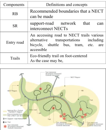
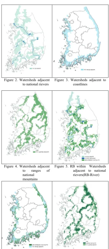
(2) Components of the criteria for the assessment were the adjacent level of national valued eco-cultural resources and natural landscape, trekking opportunity, naturalness, minimization of environmental damage by trekking, and accessibility. Table 2. Criteria for analysis to draw RB Criteria Indicators for analysis The adjacent level to Distance from main resources natural resources for needed conserve such as national NECT forest, wetlands, wild animals, etc. Accessibility Distance from main access roads and railroads. Trekking opportunities to Distance from national conservative legal conservative area areas such as wildlife refuges, wetland protection areas, ecolandscape conservation areas, cultural resources protection areas, and so on. Minimization of Exclusion of legal protected areas environmental damage 2.3 Setting up support-road network (SR network). 3.2 Support-road network(SR) for NECT. The results of setting up SR network within each three Region are as Figure 8,9,10. Figure 2. Watersheds adjacent to national rievers. Figure 3. Watersheds adjacent to coastlines. Figure 4. Watersheds adjacent to ranges of national mountains. Figure 5. RB within Watersheds adjacent to national rievers(RB-River). Figure 6. RB-Coast. Figure 7. RB-Mountain. Paths, local roads, and so on among inner BR were extracted and interconnected for SR network by each region in whole extent of Korea. The network was double-checked with relevant EGIS DB and satellite images. 2.4 Materials. It was utilized by various databases such as Ecological Map, a number of conservation area (natural parks, wetlands, ecological landscape preservation areas, wild refuges, etc), national rivers, etc, in EGIS. Forest cover type map, protection forest, Backdu-daegan protection area etc are from Forest Geographic Information System (FGIS). Whole Korea roads from Korea Transport Institute are used and protected zones for cultural assets, natural monuments in Cultural Heritage Administration are utilized. 3. RESULTS AND DISCCUSION 3.1 Recommended boundaries that a NECT can be made(RB). 1. Recommended boundaries were set up as three Regions: National river trail regions were set up by watershed adjacent to national rivers (Bukhan river, Namhan river, Han river, Sumjin river, Youngsan river, Guem river, Nakdong river) (Figure 2). National coast trail regions were set up by watershed nearby national coastlines (Figure 3). Eco-forest trail regions were set up by nearby forest patch adjacent to Baekdu-daegan (buffer 1km) and main mountains (buffer 0.5km) (Figure 4). 2. By the result of masking each of three Region(Figure 5,6,7) through analyzing potential value of eco-cultural resources, RBs for NECTs were derived from each Region. This means that NECT construction could be done within the region of BR..
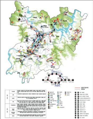
(3) Figure 8. SR within RB-River. Figure 9. SR within RB-Coast. Figure 12. A guidline for National Eco-Cultural Trail(mountainous type). Figure 13 and 14 are example designs of NECTs in local units that are located on BR and can be connected with SR that this research suggests. Thus, when the number of connecting NECTs increases, these connected with long-distance will be built up across the country.. Figure 10. SR within RBMountain. Figure 11. Final scheme of the result of SR. 3.3 Directions for designing a NECT. Guidelines for designing a NECT were suggested by MOE according to the result of SR and RB, within which a NECT construction can be done as the results of this research. When a local community and government try to design a NECT, the community can refer the design principles for making NECT lines. Based on the guideline, the community summits their plan linked with SR to MOE, then the plan is evaluated and supported financially by MOE. Figure 11 is one of various guidelines by this research and shows design directions for making NECT which is connected with SR on mountainous area.. Figure 13. A sample of National Eco-Culture Trail Plan.
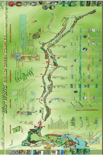
(4) This study was fulfilled by supporting from MOE and the Institute of Forest Science, Kangwon National University. Referecnces Lee, G.G. et al., 2008. Research on Guidance for National Eco-Cultural Trail, Ministry of Environment, South Korea.. Figure 14. A sample of Bio-World Trail Plan. CONCLUSION 1. NECT project is fulfilled under the government and EGIS was used essentially to distribute a guideline for the national eco-cultural trails to local governments. 2. The specific relevant information including GIS DB of NECTs, which EGIS does not have, could developed by local governments and inhabitants’ work during planning, design and running for a NECT. When they manage the project by themselves, NECT project could stimulate up and take multi-effects to improve concreteness of EGIS information of relevant NECT. 3. Proceeding community-based process to design and run a NECT will promote not only information level of EGIS but also local public relations when the information connects with web-GIS. This sort of information will have influence on linking with local revitalization. If these information connects with traffic, local, tour, culture, and history information, it would distribute better information to the public and increase their opportunities for leisure time. The conclusion to be drawn here is that these effects will contribute local economy and the national economic circulation. Acknowledgements.
(5)
수치
관련 문서
To this end, prior studies of the type of value, design paradigm and design value were considered, and three types of design value (practical value,
The characteristics of typhoons were examined via synoptic analysis and track examination, and the damage types and scales were analyzed to contribute to
Biochemical markers of bone turnover can be classified according to the process that underlie in markers of bone formation, products of the osteoblast
Chapter Ⅱ deals with infinitival complements that can be classified into 6 verb types( prefer type, try type, believe type, persuade type, promise type and
These writing systems are classified into many types which depend on how people record and preserve their writings.. Among the many types of writing systems, English
To identify problems involved in sexual harassment on the job, this study classified workers' perception into generally accepted idea on sexual harrassment,
장소 : 누드비치와 해운대의 누드 수영, 주니족 인디안(Zuni Indian) 주자들은 계속 해서 상대를 앞서려고 노력하지 않음. 그것이 그 지역에서는
1 John Owen, Justification by Faith Alone, in The Works of John Owen, ed. John Bolt, trans. Scott Clark, "Do This and Live: Christ's Active Obedience as the
