천리안위성 궤도상 시험의 지구 관측 임무 운영
조영민
*Earth Observation Mission Operation of COMS during In-Orbit Test
Young-Min Cho
*요 약
통신, 해양, 기상의 세 분야 복합 임무를 수행하는 천리안위성(Communication Ocean Meteorological Satellite: COMS)이 2010년 6월 27일 지구정지궤도로 발사된 이후 궤도상시험을 마치고 현재 정상운영 임무를 수행하고 있다. 천리안위성은 정지궤도의 동경 128.2°
에 위치한다. 세 임무를 수행하기 위해 천리안위성에는 3가지 탑재체인 기상탑재체(Meteorological Imager: MI), 해양탑재체 (Geostationary Ocean Color Imager: GOCI), 통신탑재체(Ka-band Antenna)가 실려 있다. 각 탑재체는 각각의 임무를 전담하여 수행 한다. 기상탑재체(MI)와 해양탑재체(GOCI)는 각각 기상 관측과 해양 모니터링을 위한 지구 관측 임무를 수행한다. 궤도상시험 기간 동안 천리안위성과 지상국의 기능과 성능이 지구 관측 임무 운영을 통해 점검되었다. 지구 관측 임무는 지구의 여러 영역에 대한 기상 현상 관측과 한반도 주변의 해양 환경 모니터링으로 구성된다. 천리안위성 궤도상시험에 대한 기상 및 해양 임무 운영 특성을 기술하고 천리안위성 임무 계획에 대해 논하였다. 궤도상시험 임무 운영 결과로서 시험 기간 동안의 임무 계획 결과와 위성 영상 수신 상황에 대한 통계 분석 및 종합 결과를 제시하여 궤도상시험에서 검증된 천리안위성의 임무 운영 능력과 달성된 위성 영상 수신 역량을 연구하였다.
Key Words : Communication Ocean Meteorological Satellite, COMS, Earth observation mission operation, mission planning,
satellite image reception
ABSTRACT
Communication Ocean Meteorological Satellite (COMS) for the hybrid mission of meteorological observation, ocean monitoring, and telecommunication service was launched onto Geostationary Earth Orbit on June 27, 2010 and it is currently under normal operation service after the In-Orbit Test (IOT) phase. The COMS is located on 128.2° East of the geostationary orbit. In order to perform the three missions, the COMS has 3 separate payloads, the meteorological imager (MI), the Geostationary Ocean Color Imager (GOCI), and the Ka-band antenna. Each payload is dedicated to one of the three missions, respectively. The MI and GOCI perform the Earth observation mission of meteorological observation and ocean monitoring, respectively. During the IOT phase the functionalities and the performances of the COMS satellite and ground station have been checked through the Earth observation mission operation for the observation of the meteorological phenomenon over several areas of the Earth and the monitoring of marine environments around the Korean peninsula. The operation characteristics of meteorological mission and ocean mission are described and the mission planning for the COMS is discussed. The mission operation results during the COMS IOT are analyzed through statistical approach for the study of both the mission operation capability of COMS verified during the IOT and the satellite image reception capacity achieved during the IOT.
*한국항공우주연구원 정지궤도위성관제팀([email protected])
접수일자 : 2013년 3월 7일, 수정완료일자 : 2013년 3월 12일, 최종게재확정일자 : 2013년 3월 15일
I. INTRODUCTION
According to the Korea national space program, Communication Ocean Meteorological Satellite (COMS) for the hybrid mission of meteorological observation,
ocean monitoring, and telecommunication service has been launched onto Geostationary Earth Orbit by the Ariane 5-ECA launch vehicle at 06:41 AM (Korea Standard Time:
KST) on 27 June 2010. The COMS has three payloads,
which are the Meteorological Imager (MI), the
Geostationary Ocean Color Imager (GOCI), and the Ka-band antenna for the three missions. Each payload performs its dedicated mission respectively. In order to meet the three missions simultaneously the COMS has been built to be 3-axis stabilized geostationary satellite and the satellite orbit and attitude control is an important factor in the mission operation of the satellite. The COMS is operated by the Satellite Operation Center (SOC) of the Korea Aerospace Research Institute (KARI).
The MI is the meteorological payload of COMS [1]. Its mission is to observe meteorological phenomenon around the Korean peninsula intensively and of Asian side full Earth disk periodically. The MI is operated by the KARI SOC as per mission request by the National Meteorological Satellite Center (NMSC) of Korea Meteorological Administration (KMA), who is the principal user of the image data of the MI and is in charge of reception, processing, archive, and distribution of the meteorological image data of the COMS. The GOCI is the ocean color imaging payload of COMS [2]. Its mission is monitoring of marine environments around the Korean peninsula. The GOCI is operated by the KARI SOC as per mission request by the Korea Ocean Satellite Center (KOSC) of Korea Ocean Research & Development Institute (KORDI), who is the principal user of the image data of the GOCI and is in charge of reception, processing, archive, and distribution of the ocean color image data of the COMS. The KARI SOC provides the backup of the reception, preprocessing, archive, and satellite distribution of both the meteorological image data and the ocean color image data of the COMS in the COMS normal operation service. The Ka-band antenna is the Ka band communication payload of COMS [3]. Its mission is experiment of wide-band multi-media communication service. The Ka-band antenna is operated by the KARI SOC as per mission request by the Network Control Center (NCC) of Electronics and Telecommunications Research Institute (ETRI), who is the principal user of the Ka-band antenna.
After launch the COMS has been located at the altitude of 35,800km on the 128.2° East of the Equator, geostationary Earth orbit and has gone through with the In-Orbit-Test (IOT) [4-6]. During the IOT phase the functionality and the performance of many aspects of the COMS satellite and ground station have been checked and tested through the Earth observation mission operation of meteorological observation and ocean monitoring, which
are performed by the MI and the GOCI, respectively. After completion of the IOT the COMS is currently under the normal operation for the regular mission services of meteorological observation, ocean monitoring, and telecommunication.
The mission operation of the satellite requires the control by the ground system. In KARI SOC the Satellite Ground Control System (SGCS) for the COMS consists of the Flight Dynamic Subsystem (FDS), the Mission Planning Subsystem (MPS), the Real-Time Operation Subsystem (ROS), the Telemetry, Tracking & Command (TT&C), and the ground antenna [6, 7]. The MPS synthesizes the user mission requests for 'meteorological observation and ocean monitoring' and 'satellite orbit and attitude control mission' and resolves conflicts among missions to establish daily mission plan of the Earth observation and the satellite control. The mission scenarios characteristics of the Earth observation missions, the MPS functions, and the daily mission planning during the IOT are described in the point of overview. Also, the mission operation capability of COMS is dealt with through statistical approach along with the satellite image reception status which is the result of the mission operation of COMS during IOT. Please note that this paper provides mission operation capability of the COMS which performs the first ocean monitoring mission in the world, the first meteorological observation mission in Korea, and the first simultaneous operation of meteorological and ocean mission on the geostationary Earth orbit.
Ⅱ. METEOROLOGICAL MISSION OPERATION CHARACTERISTICS
The MI has 5 spectral channels in the visible and
infrared (IR) region (1 visible channel and 4 IR channels)
and the spatial resolution of the MI is 1 km at nadir for
the visible channel and 4 km at nadir for all the IR
channels [1]. The user requirements define that the MI
shall have three observation modes of global, regional, and
local mode which are specialized for the meteorological
missions of periodical global weather observation,
intensive monitoring of meteorological phenomenon on
interested area around the Korean peninsula, and early
detection of local severe weather activity in Korea,
respectively. The global mode is used for taking images of
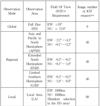
the Full Disc (FD) of the Earth. The regional observation mode is evoked for taking images of the Asia and Pacific in North Hemisphere (APNH), the Extended North Hemisphere (ENH), and Limited Southern Hemisphere (LSH). The local observation mode is activated for the Local Area (LA) coverage of 1000km × 1000 km within the area of the FD. It is noted that the Korean peninsula is found in the FD, the ENH, and the APNH, while not shown in the LSH. The LA image can be taken from any place on the Earth, while the other 4 images have their areas fixed. The LA image is usually used for intensive monitoring of meteorological phenomenon around the Korean peninsula. The user requirements of the MI observation area for FD, APNH, ENH, LSH, and LA are shown in the Table 1 and the Figure 1. During the IOT of the COMS the MI was operated mostly based on the operation modes and the images defined by the user requirements. The operational imaging areas of the 5 images include some marginal area so that they are a little larger than the requirements of the Table 1.
Table 1. MI Observation Area and Image Number
Observation Mode
Observation Area
Field Of View (FOV)*
Requirement
Image number of IOT request**
Global Full Disc (FD)
EW: ≥19°
NS : ≥ 17.6° 8
Regional
Asia and Pacific in North Hemisphere
(APNH)
EW: -2.2°~+4.3°
NS : +8.1°~+3.2° 40
Extended North Hemisphere
(ENH)
EW: -6.2°~+6.2°
NS : +8.1°~-1.8° 40
Limited Southern Hemisphere
(LSH)
EW: -6.2°~+6.2°
NS : -1.8°~-6.9° 40
Local Local Area (LA)
EW: 1000km NS : 1000km (Random selection in the FD area)
88
* FOV Center: the Satellite Nadir Point of 128.2° East, EW: East-West, NS: North-South
** Image number of IOT request: The number of images for the daily requested IOT normal meteorological schedule
In general the meteorological mission schedule for the COMS operation is planned one day early before the local date of the mission execution. The missions for 30 minutes are used as a building block for mission planning of the Earth observation of the COMS. That is, the mission
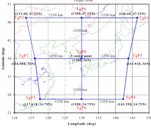
LA APNH ENH
LSH FD Korea
Figure 1. The Typical Meteorological Image Areas
planning is performed by arranging the missions by 30 minutes properly during the time zone of the mission execution (normally 24 hours). The unit mission slot of 30 minutes used for meteorological mission planning is called the MI sequence. Every MI sequence begins with a Blackbody Calibration (BBCAL) followed by meteorological images within 30 minutes. So the time interval between the start time of the BBCAL and the end time of the last image of the sequence should be within 30 minutes. And the BBCAL usually performs every 30 minutes and meteorological images are taken between the BBCALs.
The meteorological mission includes the Albedo Monitoring which is performed once a day (about 21:30 Universal Time Coordinated: UTC) for the check of the radiometric performance of the MI visible channel.
According to the user requirements of the
meteorological observation mission, the global mode is
required every 3 hours and the images of the regional
observation mode are taken for 2hours and 30 minutes
between two FD images which are separated 3 hours. The
LA of the local observation mode can be inserted after the
FD image and between/after the images of the regional
observation mode. The MI sequence for the global
observation mode consists of the one image of "FD" (pure
global mode) or the two images of "FD+LA" (combination
of global mode and local mode). The MI sequence for the
regional observation mode can be comprised of the three
images of "ENH+APNH+LSH" (pure regional mode) or the
five images of "ENH+LA+APNH+LSH+LA" (combination
of regional mode and local mode). These MI sequences
have been required by the user since the early phase of
the COMS development and prepared as the baseline of
the image sequence for the meteorological mission
operation during the COMS IOT. And the normal mission
schedule of the meteorological observation used during the
IOT phase was comprised of the combined global mode of
"FD+LA" every 3 hours and the combined regional modes of "ENH+LA+APNH+LSH+LA" between the global modes, which is hereafter called the IOT normal meteorological mission schedule.
Since the FD image is taken every 3 hours, the number of the FD images is 8 a day. The combined regional modes repeat 5 times between the FD images so that the ENH, APNH, and LSH images are taken 40 times a day, respectively. The number of LA images is 88 a day because they are included in both the combined global mode and the combined regional modes. The number of images for the daily user request of the IOT normal meteorological mission schedule is summarized in the Table 1. The daily requested IOT normal meteorological schedule is also shown in the Figure 2 in terms of the ratio of accumulated mission duration to 24 hours a day, where the duration ratio of Earth imaging is for all the images to be taken a day and the duration ratio of BBCAL is for all the 48 BBCALs a day. The mission duration ratio of the Figure 2 is the maximum allowable value which can be achieved theoretically in the IOT normal meteorological mission schedule. So, the daily total meteorological mission is requested to be performed during 87% of 24 hours a day, which is theoretical limit and the sum of the Earth imaging of 84% and the BBCAL of 3%.
Figure 2. The daily mission duration ratio of the requested IOT normal meteorological schedule (theoretical limit)
Ⅲ. OCEAN MISSION OPERATION CHARACTERISTICS
The GOCI has 8 spectral channels in the visible and near IR region of the light spectrum and the spatial resolution of the GOCI is 500m at the center of the observation area for all the channels [2]. The operational specification and procedures of ocean monitoring mission had been established during the COMS development based on the user requirements and used for the COMS ocean
mission operation during the IOT. The major characteristics of ocean monitoring mission operation are as the following. The observation area of the GOCI image is fixed with the size of 2500km×2500km around the Korean peninsula (See the Figure 3). It takes about 30 minutes to observe this area one time by the GOCI. The ocean monitoring mission of the COMS is performed one time every hour from 00:15 (UTC) to have 8 times observations during daytime (Korean local time) a day. In other words, the ocean mission operation begins at 9:15 every morning in the Korean local time and proceeds every hour until the last ocean monitoring image of the day which ends at 16:45 (KST). In addition to ocean monitoring, in-orbit calibration of the GOCI is performed at local night time periodically.
Similarly to the meteorological observation mission, the ocean mission schedule for the COMS operation is planned one day early before the local date of the mission execution and the missions for 30 minutes are used as a building block for mission planning of the Earth observation of the COMS. Since it takes about 30 minutes to complete the ocean monitoring mission one time, an ocean image in itself is used as the unit mission slot of 30 minutes for ocean mission planning.
Figure 7.2/1 : Nominal target area T arget Area
21 26 31 36 41 46 51
110 115 120 125 130 135 140 145 150
Longitude (de g)
Latitude (deg)
(1 1 7 .6 1 E, 2 4 .7 5 N)
(1 4 3 .9 2 E, 3 6 N) (1 4 6 .6 E, 4 7 .2 5 N)
(1 1 6 .0 8 E, 3 6N) (1 1 3 .4 E, 4 7 .2 5 N)
(1 4 2 .3 9 E, 2 4 .7 5 N) (1 3 0 E, 4 7 .2 5 N)
(1 3 0 E, 2 4 .7 5 N)
1250 km 1250 km
1250 km 1250 km
1250 km
1250 km
1250 km Central point 1250 km (1 3 0 E, 3 6 N)
TgP1 TgP2
TgP3 TgP4
TgP0 TgP6
TgP5 TgP7
TgP8
Figure 3. The GOCI Image Area
Figure 4. The daily mission duration ratio of the requested
ocean mission schedule (theoretical limit)
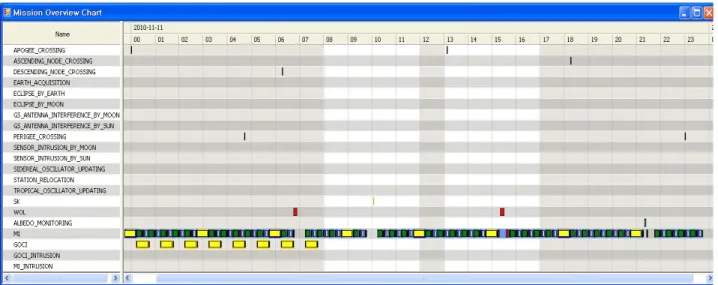
Figure 5. A daily mission schedule of the Earth observation during the COMS IOT
The daily user request for ocean mission schedule is shown in the Figure 4 in terms of the ratio of accumulated mission duration to 24 hours a day, where the duration ratio of Earth imaging is for all the ocean images to be taken a day and the duration ratio of calibration is for the in-orbit calibration of the GOCI a day. The mission duration ratio of the Figure 4 is also the maximum allowable value which can be achieved theoretically in the ocean mission schedule. So, the daily total ocean mission is requested to be performed during 17.7% of 24 hours a day, up to theoretical limit, which is the sum of the Earth imaging of 17.1% and the calibration of 0.6%.
Ⅳ. MISSION PLANNING FOR THE EARTH OBSERVATION
The COMS MPS plans the operational schedule of the Earth observation mission of the COMS. The MPS consists of three functional parts, Mission Request Gathering, Mission Scheduling, and Mission Schedule Reporting. First, the Mission Request Gathering collects the user mission requests for 'meteorological observation and ocean monitoring' and the FDS mission requests for satellite orbit and attitude control and processes them to the data with the format suitable to build a schedule. Next, the Mission Scheduling builds the mission schedule from the processed data of the mission request and provides the view of the mission schedule, the check of schedule constraints, the check of conflicts among missions, the resolution of the conflicts, the generation of the final
mission schedule files, the generation & the delivery of the mission schedule command files to be sent to the satellite, the generation of the event files for the image data processing, and the management of the mission planning files. The MPS receives additional information related to the satellite orbit, the Sun, and the Moon from the FDS for reference. Based on the user mission requests and the FDS satellite control requests the MPS plans mission schedules, generates the mission schedule commands and send them to the ROS for upload to the satellite. Finally, the Mission Schedule Reporting sends the mission planning results, that are the mission schedule and the event files for the image data processing, to the users of the Earth observation image data.
There are some constraints on the Earth observation
due to the activities of satellite management. In the COMS
operation the operational activities which affect the Earth
observation mission schedule are repeated mostly every
week. During the COMS IOT, in order to meet the
operational requirement on the satellite attitude and orbit
maintenance, the Wheel Off Loading (WOL) maneuver of
the satellite has been performed twice a day [8, 9] and the
Station Keeping (SK) maneuver of the satellite has been
carried out once a week in the East-West(EW) direction
and in the North-South(NS) direction, respectively [10,
11]. The MPS receives the mission requests for WOL and
SK with their schedule information from FDS. In the case
the meteorological observation mission or the ocean
monitoring mission conflict with the WOL or the SK, the
mission planning proceeds by resolving the conflict
normally as per the COMS mission priority rule and the
mission conflict management specifications which are predefined during COMS development before launch.
A daily (24 hours) mission schedule of the COMS Earth observation is shown in the Figure 5 for example. The Figure 5 shows the IOT normal meteorological mission schedule and the ocean mission schedule of 8 times imaging. The Figure 5 also shows two WOLs and one EW SK which are requested by the FDS for the satellite attitude and orbit control. The two WOLs occur at 06:45 (UTC) and 15:21 (UTC) respectively and the EW SK takes place at around 10 o'clock (UTC). Since these two WOLs and one EW SK should be performed simultaneously with some meteorological missions of the requested IOT normal meteorological mission schedule, there are mission conflicts, which need to be resolved by the MPS. After the mission conflict management applied, some meteorological missions are not planned in order to avoid confliction with the satellite maneuvers. Total 6 image missions of two ENH, one APNH, one LSH, and two LA are not planned due to the two WOLs and total 4 image missions of one ENH, one APNH, one LSH, and one LA are not planned due to the EW SK. The next mission conflict management is to give up total 3 image missions of one ENH, one APNH, and one LSH for the Albedo Monitoring which performs at 21:19 (UTC). So, the total image number of the IOT normal meteorological mission is reduced from 216 of the requested schedule (FD:8, ENH: 40, APNH: 40, LSH: 40, LA: 88) to 204 of the operated schedule (FD:8, ENH: 36, APNH: 37, LSH: 37, LA: 85, Albedo Monitoring: 1) in the Figure 5.
V. MISSION OPERATION RESULTS DURING THE COMS IOT
After the COMS has been launched on 27 June 2010 and reached the Geostationary Earth Orbit, the COMS IOT has been initiated for the check of the functionality and the performance of many aspects of the COMS satellite and the COMS ground station and been performed for about 7 months. In the early phase of the COMS IOT, which is called the spacecraft bus IOT phase, the in-orbit status of spacecraft bus was checked thoroughly and the satellite was arranged to the configuration ready for the payload mission operation. About 2 weeks after the launch the second IOT phase, which is called the payload IOT phase, has started for the in-orbit verification of the
functionalities and the performances of the COMS payloads and the COMS ground station [12 - 14]. Just after the payload IOT phase start, the first meteorological image of the visible channel was observed successfully by the COMS at 11:15 (KST) on 12 July 2010. The first ocean image of the COMS was acquired successfully at 15:15 (KST) on 13 July 2010. After about 42 days outgassing of the MI in the space, the first meteorological image of the IR channels was observed successfully at 19:14 (KST) on 11 August 2010. Lastly the in-orbit performances of Image Navigation and Registration (INR) of the COMS image processing system has been verified during the third IOT phase, which is called the INR IOT phase [15].
The payload IOT and the INR IOT have been carried out through the Earth observation mission operation for the observation of the meteorological phenomenon over several areas of the Earth and the monitoring of marine environments around the Korean peninsula. For the tests of payload and INR, various mission operation scenarios have been planned and executed during the both IOT phases. In the process of these tests the mission operation capability of the COMS was verified for not only the normal operation scenario but also various test mission operation scenarios. The COMS IOT has been performed by the international joint activities of KARI (Korea) and Astrium (France) in the KARI SOC, so during the IOT phase, the KARI SOC has taken the primary role for the reception, preprocessing and archive of both the meteorological image data and the ocean image data of the COMS. During the IOT phase the NMSC of KMA provides the backup of the reception, preprocessing and archive of the meteorological image data and the KOSC of KORDI provides the backup of the reception, preprocessing and archive of the ocean image data.
In this paper, about some major mission operation scenarios planned and executed during the IOT, the mission operation capability of COMS is analyzed and synthesized through statistical approach with the COMS mission planning results and the satellite image reception status which are the outcome of the COMS mission operation during the IOT. The satellite image reception status can be different slightly between primary and backup ground station depending on daily operational status of each station. In this paper the IOT image reception status is presented for only the KARI SOC.
As discussed earlier, the meteorological observation
mission is fulfilled by taking meteorological images on the
(a) Daily satellite operation rate
(b) Daily image reception number rate
Figure 6. The satellite operation status and the Earth observation image reception status of the IOT normal meteorological mission operation Earth and auxiliary images such as BBCAL and the
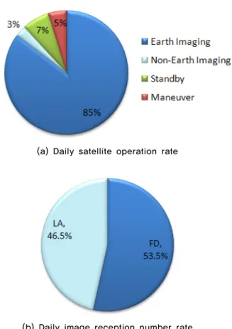
Albedo Monitoring, with the avoidance of the satellite maneuvers. Classifying these mission activities properly in point of satellite operation, the meteorological mission schedules of the IOT have been investigated to obtain the average values of daily satellite operation rate for the meteorological mission operation modes of Earth Imaging, Non-Earth Imaging, Standby, and Maneuver, which are introduced simply for easy understanding of the meteorological mission operation status of the COMS in this paper and defined as the following. The Earth Imaging mode is the operation status that the COMS performs meteorological observation with the Earth scanned by the MI and one of the MI images of FD, ENH, APNH, LSH, and LA is being taken by the COMS. The Non-Earth Imaging mode is the operation status that the COMS is operating to observe anything except the Earth by scanning the outside of the Earth with the MI for the support of the meteorological observation of the Earth such as the BBCAL and the Albedo monitoring. The Standby mode is the operation status that the COMS is waiting for spacecraft maneuver or imaging with the MI put on standby. Note that in this mode the COMS performs most of the spacecraft on-board MI command processing to execute the MI imaging and the movement between the MI images. The Maneuver mode is the operation status that the COMS performs the WOL maneuver or the SK maneuver for the satellite attitude/orbit maintenance and then no MI image is taken during the maneuver itself, the preparation before it, and the tranquilization after it in order to avoid any possible conflict with the maneuver. The daily satellite operation rate is the ratio of the total time consumed by each operation mode with respect to the 24 hours of a day. Also the daily satellite image reception status has been monitored in the COMS ground station during the IOT phase. The satellite image reception status of the IOT can be summarized by using the daily reception number rate of each MI image which is the ratio of the received image number of each MI image (FD, ENH, APNH, LSH, or LA) with respect to the total number of received Earth images of a day.
For the meteorological observation mission, the IOT mission operations studied in this paper are the IOT normal meteorological mission operation, the 24 hours FD imaging operation, and the typhoon monitoring operation.
The IOT normal meteorological mission operation has
been performed during the most period of the IOT phase.
In this period, the IOT normal meteorological mission schedule has been operated for the in-orbit verification of the functionalities and the performances of the MI and the COMS ground station. The daily satellite operation rate of the Figure 6 (a) was obtained by analyzing the meteorological mission planning results of the COMS MPS for 3 months during the IOT phase. In these months the meteorological mission was operated with the IOT normal meteorological mission schedules in normal operation status of the satellite without any mission operation failure. The average values of daily reception number rate of FD, ENH, APNH, LSH, and LA in the IOT normal meteorological mission schedules are shown in the Figure 6 (b). The LA images were taken for the Korean peninsula in most of the IOT normal meteorological mission schedules. The daily image reception number rate of the Figure 6 (b) is based on the image reception results of the KARI SOC for the 3 months of the IOT phase.
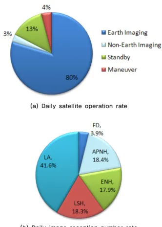
During the 3 months IOT normal meteorological mission
operation, the Earth imaging were taken on the average
for 80% of 24 hours a day and the satellite were operated
(a) Daily satellite operation rate
(b) Daily image reception number rate
Figure 7. The satellite operation status and the Earth observation image reception status of the 24hours FD imaging mission operation in the Non-Earth imaging, the Maneuver, and the Standby
for 3%, 4%, and 13% of 24 hours a day, respectively. So, the IOT normal meteorological mission was performed with satellite operation rate of 83% a day, which is applicable for both the Earth imaging and the Non-Earth imaging. According to the daily requested mission duration of the Figure 2, the theoretically maximum allowable satellite operation rate of the IOT normal meteorological mission is 87% a day. This value is reached by summing the rates of the Earth imaging, the Non-Earth imaging, and the Maneuver in the Figure 6 (a).
This means that the meteorological mission request is made up to the theoretical limit and all the requested meteorological missions have been operated by the COMS except for the missions which are not planned due to confliction with the satellite maneuvers. That is, all the COMS meteorological observation missions were operated successfully 24 hours a day over 3 months with the IOT normal meteorological mission schedule, which is a good verification of the stability and the robustness of the meteorological mission operation on a top system level in all aspects of the satellite bus/payload, the ground station facilities/ equipments, and the ground operator activities.
Among the total Earth images which were taken with the satellite operation rate of 80% and received by the ground station a day, the number of FD images is 3.9% of the number of total Earth images, the ENH is 17.9%, the APNH is 18.4%, the LSH is 18.3%, and the LA is 41.6%.
In the Figure 6 (b) it can be noticed that many LA images were taken to have intensive monitoring of meteorological phenomenon around the Korean peninsula, which is one of key purposes of the COMS meteorological mission.
Therefore, in point of operation rate and stability on the meteorological mission it is clear that the normal operation service of the COMS can begin based on this operational verification.
The 24hours FD imaging has been performed for the in-orbit test of INR performances for several days of the IOT phase. The meteorological mission schedule of the 24hours FD imaging is comprised of the MI sequences of
"FD" (global mode only) or "FD+LA" (combination of global mode and local mode) every 30minutes for 24 hours a day. The LA images were taken for the Korean peninsula. The average values of the daily satellite operation rate for the 24hours FD imaging mission operation are shown in the Figure 7 (a). The average values of daily image reception number rate for the
24hours FD imaging are shown in the Figure 7 (b). It is noted in the Figure 7 (a) that the COMS spends more time for the Earth imaging in case of more large images such as the 24hours FD imaging.
The typhoon monitoring has been performed for the check of typhoon tracking capability for a few days of the IOT phase. The meteorological mission schedule of the typhoon tracking is made up of the MI sequences of "LA"
(local mode only) every 2minutes for 24 hours a day. The
LA images were taken for the Korean peninsula to
monitor the typhoon of Kompasu which crossed the middle
area of the Korean peninsula on 2 September 2010 and
brought severe damages to Korea. The average values of
daily satellite operation rate for the typhoon monitoring
mission operation are shown in the Figure 8 (a). The
average values of daily image reception number rate for
the typhoon monitoring are shown in the Figure 8 (b). It
takes less than 1 minute to acquire a LA image, so the
operation rate of Standby mode was more than 50% in
monitoring the typhoon every 2minutes. FD images were
taken around the local midnights of the typhoon
(a) Daily satellite operation rate
(b) Daily image reception number rate
Figure 8. The satellite operation status and the Earth observation image reception status of the typhoon monitoring mission operation
Figure 9. The daily satellite operation status of the ocean monitoring mission operation monitoring days. This is the reason that the image
reception number rate of FD is shown in the Figure 8 (b).
Please note that the three mission operations, the IOT normal meteorological mission, the 24hours FD imaging mission, and the typhoon monitoring mission, show different daily satellite operation rates of the Earth imaging and different image numbers one another. And the 24hours FD imaging mission has the highest Earth imaging operation rate and the least Earth images among the three missions. This means that the daily satellite operation rate and the image number depend on meteorological mission scenario and it is not always true that higher satellite operation rate gives more images.
Therefore, it is important to study which images needs how many for their application and to analyze trade-off between the satellite operation rate and the image number, not just to insist the highest satellite operation rate and the most images together.
The ocean monitoring mission operation of the COMS is much simpler than the meteorological observation mission operation. The ocean monitoring mission is fulfilled by the daytime ocean imaging and the GOCI
calibration. Similarly to the meteorological observation mission, the ocean monitoring mission schedules of the IOT phase have been investigated to obtain the average values of daily satellite operation rate for the ocean mission operation modes of Earth Imaging, Calibration, Standby, and Maneuver, which are introduced simply for easy understanding of the ocean mission operation status of the COMS in this paper and defined as the following.
The Earth Imaging mode is the operation status that the COMS performs ocean monitoring with the Earth imaged by the GOCI. The Calibration mode is the operation status that the COMS is operating to calibrate the GOCI. The Standby mode is the operation status that the COMS is waiting for spacecraft maneuver, imaging the Earth, or calibration. The Maneuver mode is the operation status that the COMS performs the NS SK maneuver for the satellite orbit maintenance and then the GOCI image is not to be taken during the maneuver itself, the preparation before it, and the tranquilization after it. Only the North-South SK is taken into account in the Maneuver mode of the ocean mission operation because the WOL and the East-South SK are scheduled to perform outside of the GOCI imaging. The daily satellite operation rate is the ratio of the total time consumed by each operation mode with respect to the 24 hours of a day. The daily satellite operation rate of the Figure 9 was obtained by using the ocean mission planning results of the COMS MPS for the same 3 months as those of the IOT normal meteorological mission schedules during the IOT phase.
The daily satellite operation rate of the Figure 9 was
obtained for normal operation status of the COMS without
any mission operation failure during the IOT. The daily
satellite operation rate of the Earth (ocean) imaging is
17.0% of 24hrs in the Figure 9. According to the daily
requested mission duration of the Figure 4, the
theoretically maximum allowable satellite operation rate of
the ocean mission is 17.7% a day. This value is reached by summing the rates of the Earth imaging, the calibration, and the Maneuver in the Figure 9. This means that the ocean mission request is made up to the theoretical limit and all the requested ocean missions have been operated by the COMS except for the missions which are not planned due to confliction with the satellite maneuvers. That is, all the COMS ocean monitoring missions were operated successfully 8 times a day over 3 months during the IOT, which is a good verification of the stability and the robustness of the ocean mission operation on a top system level in all aspects of the satellite bus/payload, the ground station facilities/equipments, and the ground operator activities. Since ocean images are taken in the same operation condition except for imaging time, they are all the same kind and there is no need to look into the composition of the received images in the point of satellite mission operation, unlike the MI images.
Therefore, in point of operation rate and stability on the ocean mission it is clear that the normal operation service of the COMS can begin based on this operational verification. As mentioned above, all the requested schedules of both meteorological and ocean missions have been operated by the COMS except for the missions conflicted with the satellite maneuvers. This is important operational verification about that there is no interference between meteorological and ocean mission each other even though simultaneous operation of meteorological and ocean mission is performed.
Ⅵ. CONCLUSIONS
Communication Ocean Meteorological Satellite (COMS) for the hybrid mission of meteorological observation, ocean monitoring, and telecommunication service was launched onto Geostationary Earth Orbit on June 27, 2010 and it is currently under normal operation service after the In-Orbit Test (IOT) phase. During the IOT phase the functionalities and the performances of the COMS satellite and ground station have been checked and tested through the Earth observation mission operation of meteorological observation and ocean monitoring.
The mission operation characteristics for the Earth observation of meteorological observation and ocean monitoring are described respectively. The baseline schedule for the meteorological mission operation during
the COMS IOT was the IOT normal meteorological mission schedule which was comprised of the combined global mode of "FD+LA" every 3 hours and the combined regional modes of "ENH+LA+APNH+LSH+ LA" between the global modes. The ocean monitoring mission of the COMS is performed one time every hour from 00:15 (UTC) to have 8 times observations during daytime (Korean local time) a day. In-orbit calibration of the GOCI is executed at local night time periodically.
The COMS mission planning for the Earth observation is described in the point of overview. The COMS MPS is a part of the satellite operation system of COMS ground station. The MPS synthesizes the user mission requests for 'meteorological observation and ocean monitoring' and the satellite orbit and attitude control mission, resolves conflicts among missions, and establishes daily mission plan of the Earth observation and the satellite control.
The mission operation results during the COMS IOT are analyzed through statistical approach for the study of the mission operation capability of COMS achieved and verified during the IOT and the satellite image reception status during the IOT. The meteorological mission schedules of the IOT have been investigated to obtain the average values of daily satellite operation rate for the meteorological mission operation modes of Earth Imaging, Non-Earth Imaging, Standby, and Maneuver. Also the satellite image reception status of the IOT is summarized by using the daily reception number rate of each MI image. The ocean monitoring mission schedules of the IOT phase have been investigated to obtain the average values of daily satellite operation rate for the ocean mission operation modes of Earth Imaging, Calibration, Standby, and Maneuver.
In summary, during the IOT it was tested that the
COMS meteorological observation mission was operated
successfully with the imaging operation rate more than
83% of 24 hours a day over 3 months with respect to the
IOT normal meteorological mission schedule. The
maximum imaging operation rate of about 88% was
achieved in the 24 hours FD imaging operation. It was
interesting to test the operational capability of the typhoon
monitoring during the IOT. The operation results of the
three meteorological missions confirm that the daily
satellite operation rate and the image number depend on
meteorological mission scenario. Also the mission
operation results during the COMS IOT show that the
COMS ocean monitoring mission was operated
successfully 8 times a day during the IOT. Therefore, the COMS operational capability of the Earth observation mission have been verified successfully during the IOT with respect to that the meteorological mission is required to be continued 24 hours a day and 365 days a year and the ocean mission is required to be operated 8 times a day and 365 days a year. And, since this IOT operational verification also means that the stability and the robustness of the mission operation are verified on a top system level in all aspects of the satellite bus/payload, the ground station facilities/equipments, and the ground operator activities, it is clear in point of mission operation rate and stability that the normal operation service of the COMS can begin.
Finally, taking into account that the COMS performs the first ocean monitoring mission in the world and the first meteorological observation mission in Korea on the geostationary Earth orbit, it is expected that the results of this paper can be a useful reference to discussion about similar future mission operation such as the COMS follow-on, too.
ACKNOWLEDGEMENTS
The COMS is operating by the cooperation of KARI, KMA, KORDI, and ETRI under the financial supports from the Korean government ministries of 'Ministry of Education, Science and Technology (MEST)', KMA, and 'Ministry of Land, Transportation, and Maritime Affairs (MLTM)'. Many thanks are given to their cooperation and supports. The COMS operation team of the KARI SOC, especially COMS operators, are appreciated highly for their efforts and passions devoted to the COMS operation.
REFERENCES
[1] Y. Cho and H. Youn, “Characteristics of COMS Meteorological Imager”, Proceedings of SPIE 2006 Sensors, Systems, and Next-Generation Satellites X, Stockholm, Sweden, Vol. 6361, pp. 63611G-1 - 63611G-8, Sep.11-13 2006.
[2] H. Kim, G. Kang, B. Ellis, M. Nam, H. Youn, F. Faure, P.
Coste, and P. Servin, “Geostationary Ocean Color Imager (GOCI), Overview and Prospect”, Proceedings of 60th International Astronautical Congress, Daejeon, Republic of Korea, IAC-09.B1.3.9, pp. 1-11, Oct. 12-16 2009.
[3] S. Lee, J. Jo, M. You, J. Choi, and K. Ahn, “Ka band
Communication Payload System Technology of COMS”, The Journal of the Korea Society of Space Technology, Vol.
5, No. 2, pp. 75-81, 2010.
[4] H. Kim, Y. Kim, Y. Cho, G. Kang, D. Lee, and Y. Chang,
“On COMS Optical Sensors and Their Applications”, Proceedings of 2010 International Symposium on Remote Sensing / 2010 International Conference on Space, Aeronautical and Navigational Electronics, Jeju, Republic of Korea, 271-274, Oct. 27-29, 2010.
[5] M. You, J. Jo, S. Lee, and J. Kim, “In-Orbit Test of COMS Ka band Communication Payload”, The Journal of the Korea Society of Space Technology, Vol. 6, No. 1, pp. 109-114, 2011. (In Korean)
[6] B. Lee, I. Kim, S. Lee, Y. Hwang, W. Jung, J. Kim, H. Kim, H. Lee, S. Lee, Y. Cho, and B. Kim, “Operational Validation of the COMS Satellite Ground Control System during the First Three Months of In-Orbit Test Operations”, The Journal of the Korea Society of Space Technology, Vol. 6, No. 1, pp. 37-44, 2011.
[7] S. Lee, Y. Uhm, Y. Cho, B. Park, B. Kim, K. Yang, Y. Chun, C. Park, C. Han, and J. Suk, “An Introduction of Real-Time Operation Task for the COMS”, Proceedings of the 2010 KSAS Spring Conference, Gyeongju, Republic of Korea, Apr. 13-15, pp. 1207-1211, 2011. (In Korean)
[8] S. Lee, B. Park, B. Kim, G. Ju, and Y. Park, “A Study on the East/West Station Keeping Planning Considering Wheel Off-Loading”, Journal of the Korean Society for Aeronautical and Space Sciences, Vol. 34, No. 9, pp. 60-66, 2006. (In Korean)
[9] B. Park, Y. Park, and S. Lee, “COMS Momentum Dumping Optimal Thruster Set Selection”, Journal of the Korean Society for Aeronautical and Space Sciences, Vol. 34, No. 11, pp. 54-60, 2006. (In Korean)
[10] S. Lee, Y. Cho, Y. Park, B. Park, B. Kim, K. Yang, and Y.
Chun, “An Introduction of the N/S Station Keeping Operations for the COMS”, Proceedings of the 2010 KSAS Fall Conference, Jeju, Republic of Korea, pp. 1068-1071, Nov.
11-12, 2010. (In Korean)
[11] B. Lee, Y. Hwang, H. Kim, and S. Park, “East-West Station-Keeping maneuver strategy for COMS satellite using iterative process”, Advances in Space Research, Vol.
47, Iss. 1, pp. 149-159, 2011.
[12] K. Jin and S. Seo, “In Orbit Radiometric Calibration Tests of COMS MI infrared Channels”, Korean journal of Remote Sensing, Vol. 27, No. 3, pp. 369-377, 2011.
[13] G. Kang and H. Youn, “Geostationary Ocean Color Imager (GOCI) On-Orbit Radiometric Calibration”, Proceedings of 2011 International Symposium on Remote Sensing, Yeosu, Republic of Korea, pp. 116-119, Nov. 2-4, 2011.
[14] G. Kang, P. Coste, H. Youn, F. Faure, and S. Choi, “An
In-Orbit Radiometric Calibration Method of the
Geostationary Ocean Color Imager”, IEEE Transactions on
Geoscience and Remote Sensing, Vol. 48, No. 12, pp.
4322-4328, 2010.
[15] K. Jin, S. Seo, H. Kim, G. Ju, and K. Yang, “COMS Geometric Calibration System and Its In-Orbit Functional and Performance Tests”, Korean journal of Remote Sensing, Vol. 27, No. 4, pp. 495-506, 2011. (In Korean)
저자
조 영 민(Young Min Cho) 정회원