Geosciences Journal
Vol. 10, No. 3, p. 249−262, September 2006
Structural and provenance analyses of a newly defined major fault: The Homyeong Fault as a northern boundary fault of the Cretaceous Nagdong Trough, South Korea
ABSTRACT: The Homyeong Fault on the Yecheon Shear Zone is newly defined and described in the northwestern part of North Gyeongsang Province, South Korea. In the study area, the base- ment rocks consist of the Precambrian rocks and Jurassic granitoid, and are dextrally deformed by the Jurassic Yecheon Shear Zone to the north of the Cretaceous Gyeongsang Supergroup in a ductile manner. These basement rocks are covered with unconformity by the Sindong Group, the lowest part of the Gyeongsang Supergroup.
The Homyeong Fault runs on the Yecheon Shear Zone, and is marked by cataclasite that contains mylonite fragments originating from the mylonitic rocks of the Yecheon Shear Zone and that shows sinistral sense of shear with normal-fault component dipping bas- inward, which indicates reactivation of the Yecheon Shear Zone.
The conglomerates of the northern part of the Sindong Group usually contain the gravels of granite, quartzite, blackish quartzite, mylo- nite, ultramylonite, and mudstone. Petrological similarity between these gravels and the basement rocks suggests that most of the gravels were very likely derived from the Yecheon Shear Zone and its vicinity. Considering the Korean Cretaceous basins mostly formed by sinistral reactivation of the pre-existing shear zones, it can be judged that the reactivation of the Yecheon Shear Zone caused the basement rocks nearby the Homyeong Fault, or the Yecheon Shear Zone and its vicinity, to be deposited as the gravels to the Nagdong Trough where the Sindong Group was filled on the south of the fault. This gives new proposals that the Homyeong Fault had played a role as a northern boundary fault of the Nagdong Trough and also that the inversion tectonics from Jurassic dextral to Cretaceous sinistral motions, observed in the eastern margin of Asia, had an effect on the formation of the Nagdong Trough.
Key words: Homyeong Fault, Yecheon Shear Zone, Sindong Group, con- glomerate provenance, reactivation
1. INTRODUCTION
The Gyeongsang Supergroup widely distributed in the southeastern part of the Korean Peninsula (Fig. 1A) is the most studied Cretaceous nonmarine deposit in Korea. Its basin-forming tectonics, however, has not been fully under- stood yet. The Nagdong Trough, which is filled with the lowest part of the Gyeongsang Supergroup, or the Sindong Group, was the most embryonic basin of the supergroup.
The present configuration of the Sindong Group does not
reflect its original distribution because of faulting, folding, and erosion after the deposition. While difficult, it is very important to estimate its original distribution in discussing the formation of the Nagdong Trough. The eastern bound- ary of the Nagdong Trough has been relatively well con- strained from the stratigraphical distribution (Chang, 1977) and illite crystallinity analysis of the Gyeongsang Super- group (Lee and Lee, 2001) (Fig. 1B). Other boundaries of the trough, however, are still unclear.
The northern margin of the Nagdong Trough is supposed to be bounded by a contemporaneous fault dipping basin- ward (Chang, 1977), which is still unclear but can be assumed to have been active during the formation of the Nagdong Trough, from the following reasons: (1) maximum thick- ness in the northern part of the Sindong Group (Chang, 1977; Choi et al., 1982), (2) alluvial-fan wedges involving debris flow deposit, which are banked against the northern margin of the Sindong Group (Rhee et al., 1998), and (3) fining-upward cycles of sedimentation of the Sindong Group (Chang, 1977). Paleocurrent analyses of the Sindong Group reveal sediment transport from the north and northwest (Chang and Kim, 1968; Rhee, 1998). In this way, the fault- ing along the northern margin of the Nagdong Trough is assumed to have encouraged the pre-Cretaceous basement rocks nearby the fault to be deposited as clasts to the trough on the south of the fault. Finding the fault and analyzing the provenance of the Sindong Group can be judged as the best ways to verify this assumption.
We have carried out structural and provenance works in the northwestern part of North Gyeongsang Province with special notice of the fact that the Sindong Group never occurs to the north of the Yecheon Shear Zone. Fortunately, we discovered a sinistral cataclastic fault running on the Yecheon Shear Zone and named it the Homyeong Fault after its type locality. In this paper, we define and describe the Homyeong Fault and examine petrological similarity between the gravels in the northern part of the Sindong Group and the pre-Cretaceous basement rocks to the north of the Sindong Group. By combining structural field data with the result of conglomerate provenance of the Sindong
Kosuke Egawa*
Daekyo Cheong
Shigeru Otoh } Department of Geology, Kangwon National University, Kangwon 200-701, South Korea Department of Earth Sciences, University of Toyama, Toyama 930-8555, Japan
*Corresponding author: [email protected]
Group, we argue that the Homyeong Fault is a northern boundary fault of the Nagdong Trough.
2. OUTLINE OF GEOLOGY
The Yeongnam Massif in the southeastern part of the Korean Peninsula has the Precambrian basement rocks that are mainly covered by the Paleozoic to Mesozoic rocks (Reed- man and Um, 1975; Lee, 1988). The Honam Strike-Slip Duplex (HSSD) or Honam Shear Zone deforms the pre-Cretaceous rocks of the Yeongnam Massif in a ductile manner (Yanai et al., 1985; Otoh et al, 1994) and consists of Early to Mid- dle Jurassic dextral shear zones (Kwon and Ree, 1997; Cho et al., 1999; Otoh et al., 1999). They are covered with uncon- formity by the Cretaceous nonmarine deposit, correctively called the Gyeongsang Supergroup, which is the main con- stituent of the Gyeongsang Basin (Chang and Park, 2003) and comprises the Sindong, Hayang, and Yucheon groups
in ascending order (Chang, 1975, 1977). Four subbasins are recognized responsible for the deposition of the Gyeongsang Supergroup from the stratigraphical and sedimentological distinctions: the Nagdong Trough filled with the Sindong Group, and the Yeongyang, Euiseong, and Milyang subba- sins filled with the Hayang and Yucheon groups (Chang, 1975).
In the study area (Fig. 2), the northwestern part of North Gyeongsang Province, the basement rocks comprise the Precambrian rocks and Jurassic Yeongju Granite. They are deformed by the Jurassic Yecheon Shear Zone, a constituent of the HSSD, and are unconformably covered by the Cre- taceous Sindong Group. The western terminal part of the Andong Fault cut the Sindong Group and its basement rocks.
2.1. Precambrian Rocks
The Precambrian rocks in the study area were originally described by Won and Kim (1969) and Yoon et al. (1988)
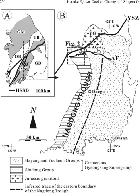
Fig. 1. (A)Simplified map showing the geology in South Korea (modified after Han et al., 2006). GM=Gyeonggi Massif, OB=Ogcheon Belt, YM=Yeo- ngnam Massif, TB=Taebaegsan Basin, GB=Gyeongsang Basin,
HSSD=Honam Strike-Slip Duplex.
(B) Geological map of the Gyeong- sang Supergroup and its vicinity (mod- ified after Kang et al., 1995). The inferred eastern boundary of the Nag- dong Trough is based on Lee and Lee (2001). YG=Yeongju Granite, AG
=Andong Granite, YSZ=Yecheon Shear Zone, AF=Andong Fault.
Structural and provenance analyses of the Homyeong Fault 251
Fig. 2. (A) Geological map of the study area, the northwestern part of North Gyeongsang Province. The map is mostly based on our original data, but the distribution of the Sindong Group is modified after Won and Kim (1969), Kim et al. (1977), and Yoon et al. (1988).
Note that the Homyeong Fault runs on the Yecheon Shear Zone. YSZ=Yecheon Shear Zone, HF=Homyeong Fault, AF=Andong Fault.
as age-unknown biotite granitic gneiss, leucocratic granitic gneiss, quartz-feldspar gneiss, and porphyroblastic granitic gneiss. In this study, these rocks except the quartz-feldspar gneiss are collectively treated as granitic gneissose because of few distinguishing features between them. The quartz-feld- spar gneiss is described as the Hamchang Granite.
The granitic gneissose occurs in northern and eastern Sangju, and southern Yecheon, and is usually medium- to coarse-grained biotite metagranite consisting of quartz, pla- gioclase, biotite, and microcline, and small amount of sil- limanite, muscovite, myrmekite, kyanite, and zircon. Quartz crystals show strong wavy extinction.
The Hamchang Granite occurs in an east-trending elon- gated area, from northern Sangju to southern Yecheon, and is mainly sandwiched between the Weonnam Group and Yeongju Granite and partly between the granitic gneissose and Weonnam Group. The Hamchang Granite is very coarse- grained pinkish microcline metagranite consisting of quartz, microcline, plagioclase, and biotite, and small amount of myrme- kite and sillimanite. Microcline crystals are commonly the largest grains (around 10 mm in size) among them. Quartz crystals display wavy extinction.
The Weonnam Group in this paper was originally defined by Lee and Kim (1968) and Yoon et al. (1988) as quartzite of the Keumgogri Schist, Daegasan Gneiss, and banded gneiss for age-unknown rocks. Chang (1990) lithologically correlated them with the Weonnam Group and discrimi- nated the Yecheon Shear Zone on the basis of his study of deformation in Yecheon. This paper follows the classification of Chang (1990). The Weonnam Group is very fine-grained holocrystalline whitish metaquartzite consisting mainly of quartz, and small amount of sillimanite, zircon, and mus- covite. Quartz crystals are uniform in grain size (about 0.3 to 0.5 mm) and show wavy extinction.
2.2. Jurassic Yeongju Granite
The Yeongju Granite in the study area occurs on the north
of Sangju, Jeomchon, and Yecheon, and is regarded as a southwestern extension of the Buseok Pluton in the south- western part of the Yeongju Granite body reported by Lee et al. (1998) and Hwang et al. (1999). The Yeongju Granite is medium- to coarse-grained holocrystalline diorite and tonalite consisting mainly of plagioclase, biotite, quartz, orthopyroxene, and clinopyroxene, and small amount of sil- limanite, hornblende, zircon, apatite, and allanite. Subhedral plagioclase crystals (about 3 to 5 mm in grain size) gener- ally show elongated albite twin and combined albite-Carls- bad twins. No crystals show marked wavy extinction.
2.3. Jurassic Yecheon Shear Zone
The Yecheon Shear Zone (Chang, 1990) runs from Sangju, through Jeomchon, to Yecheon in the study area. The Yecheon Shear Zone comprises mylonitic rocks, which have been orig- inated mainly from the Weonnam Group, and partly from the granitic gneissose and Hamchang Granite. The foliation of the mylonitic rocks strikes E to ENE and dips steeply to N.
The degree of shear deformation of the basement rocks is heterogeneous, and several intensely-mylonitized zones are distinguished within the shear zone. We assume that the aspect ratio (ratio of long axis/short axis) of augens in the mylonitic rocks reflects the amount of strain at least after the formation of augens. Hence we interpret that the mylo- nitic rock having the augens with the aspect ratio of 4 or smaller has a lower strain than the mylonitic rock having the augens with the aspect ratio of more than 4. In this paper, the former is called mylonite (with the average aspect ratio of 2) and the latter is called ultramylonite (with the average aspect ratio of 7).
2.4. Cretaceous Sindong Group
The Sindong Group in this paper occurs in eastern Sangju, southern Yecheon, and Euiseong. The Sindong Group consists
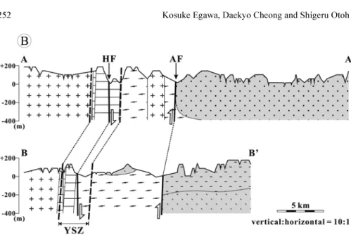
Fig. 2.Continued. (B) Vertical sections of the geological map.
Structural and provenance analyses of the Homyeong Fault 253
of the Nagdong, Hasandong, and Jinju formations in ascend- ing order (Chang, 1975, 1977). The Sindong Group generally occurs on the south of the Andong Fault, while the Hasan- dong Formation is partly present to its north (Chang, 1977;
Yoon et al., 1988). The Hasandong Formation in its northern part is subvertically overturned and structurally overlain by the granitic gneissose due to reverse faulting of the Andong Fault (Fig. 3). No strata of the Sindong Group occur on the north of the Yecheon Shear Zone. In the study area, the bed- dings of the Sindong Group strikes NW to NWN and dips gently to NE. The Sindong Group in the study area consists of alluvial-fan conglomerate, which is interfingered with black shale in the Nagdong formation and reddish mudstone in the Hasandong Formation (Chang, 1977). Paleocurrent analyses show sediment transport from the north and northwest of the Sindong Group (Chang and Kim, 1968; Rhee et al., 1998).
3. HOMYEONG FAULT 3.1. Definition
Newly defined. The Homyeong Fault is named after the type locality (Homyeong, Yecheon County, North Gyeong- sang Province) (Fig. 4).
3.2. Distribution
In the study area, the Homyeong Fault runs from Homy- eong to Yeongsun for at least 18 km with an average width of 40 m. The outcrops of the fault were discovered at three sites in this study: from east, Homyeong, Gaepo, and Yeo- ngsun. The Homyeong Fault occurs on the Yecheon Shear Zone. No strata unconformably cover and no faults or dykes cut the Homyeong Fault.
3.3. Lithology
The lithology of the Homyeong Fault is heterogeneous, which is supported by the difference of protoliths and degree of cataclastic fragmentation of the rocks in the fault.
As a whole, the degree of rock fragmentation gets weaker from east to west.
In Weolpo-ri, Homyeong (Fig. 4), the type locality, the Homyeong Fault occurs at the northern margin of the Yecheon Shear Zone with width of about 50 m (Fig. 4A).
The Homyeong Fault is composed of non-foliated catacla- site derived from ultramylonites in the Yecheon Shear Zone.
The protoliths of the ultramylonite are metaquartzite of the Weonnam Group. The cataclasites along the Homyeong Fault
Fig. 3. Andong Fault nearby Heunhyo- ri, Pungyang. (A) Outcrop of the boundary between the cataclastic gra- nitic gneissose and the boulder con- glomerate of the Hasandong Formation along the Provincial Road 916. Large arrow indicates the fault sense.(B) Photomicrograph of non- foliated cataclasite derived from the granitic gneissose. PPL.
consist of very angular mylonite fragments, whose size are heterogeneous of ~10 cm (Fig. 4B), and of much finer grains surrounding the fragments (Fig. 4C). The cataclasites are usually greenish. Microscopic observation revealed that the cataclasites have chlorite, calcite, and pyrite as secondary minerals. The tectonic foliation and lineation are unclear and difficult to recognize.
In Dongsong-ri, Gaepo (Fig. 5), to the west of Homy- eong, the Homyeong Fault is located at the central zone of the Yecheon Shear Zone with width of around 30 m (Fig. 5A).
The Homyeong Fault consists of foliated cataclasite which has been originated from mylonitized metaquartzite of the Weonnam Group and shows cataclastic texture. The frag- ments in the cataclasites are very angular and heterogeneous of ~2 cm in size. The cataclasites are usually brownish. The tectonic foliation strikes N70°E and dips 80°S (Fig. 5B).
The lineation is unclear. Microscopically, quartz crystals show strong wavy extinction and are elongated into a sym- metric augen shape. The average aspect ratio of quartz augens in the cataclasites is 3.1 on horizontal section and 2.6 on vertical section. The augens evidently show sinistral or top-to-the-east sense of shear with normal-fault compo-
nent dipping subvertically to S (Figs. 5C and D).
In Imok-ri, Yeongsun (Fig. 6), to the west of Gaepo, the Homyeong Fault runs at the central zone of the Yecheon Shear Zone with width of approximately 50 m (Fig. 6A). In the fault, the mylonitized granitic gneissose is cataclasti- cally fractured in part, which is defined by non-foliated cat- aclasite with narrow fracture bands of ~3 mm in width (Fig.
6B). The tectonic foliation and lineation are unclear, while the fracture bands strike N60°E and dip 70°S. The catacla- sites are generally greenish. Under the microscope, chlorite is observed as a secondary mineral and arranged subparallel to the fracture bands. The fragments in the fracture bands display angular shape and are ~0.5 mm in size. The fracture bands have S–C fabric on horizontal section, which clearly shows sinistral or top-to-the-east sense of shear (Fig. 6B). A normal-fault component dipping steeply to S is slightly observed on vertical section based on domino-like arrange- ment of the fractured K-feldspar crystals (Fig. 6C).
3.4. Age
Early Cretaceous, as will be discussed later.
Fig. 4. Homyeong Fault in Weolpo-ri, Homyeong, the type locality.(A) Route map. (B) Outcrop of non-foliated cataclasite including large fragments of around 10 cm in size. (C) Photomicrograph of non-foliated cataclasite.
Structural and provenance analyses of the Homyeong Fault 255
4. CONGLOMERATES
57 conglomerate sites were selected in and around Euiseong to know the petrological and sedimentological characteris-
tics of the gravels in the northern part of the Sindong Group. The conglomerates in the northern part of the Sin- dong Group commonly include six lithologic types of gravels;
granite, quartzite, blackish quartzite, mylonite, ultramylo-
Fig. 5. Homyeong Fault in Dongsong- ri, Gaepo. (A) Route map. (B) Outcrop of foliated cataclasite dipping subver- tically to S. Dotted lines indicate foli- ation. (C) Photomicrograph of foliated cataclasite on horizontal section. CPL.
(D) Photographs of polished hands sam- ples of foliated cataclasite on vertical section. Large arrows indicate the shear sense.
nite, and mudstone gravels. The gravels are rounded except the mudstone gravels that are angular to subangular. The granite and quartzite gravels were found at all 57 sites, whereas the mylonite gravels were at 47 sites, the blackish quartzite and ultramylonite gravels were at 39 sites, and the mudstone gravels were at 5 sites.
4.1. Lithology of Gravels 4.1.1. Granite Gravels
The granite gravels consist of biotite and microcline gran- ites, which are all non- to very slightly deformed. The biotite granite in the gravels is medium- to coarse-grained biotite metagranite comprising crystals of quartz, plagioclase, micro- cline, and biotite, and small amount of sillimanite, myrmekite, kyanite, and zircon. On the other hand, the microcline granite in the gravels is very coarse-grained pinkish metagranite com- posed of quartz, microcline, plagioclase, and biotite, and small amount of sillimanite. Microcline crystals of the microcline granite are the largest (about 10 mm in grain size) of all.
Quartz crystals of both granites show wavy extinction.
4.1.2. Quartzite and Blackish Quartzite Gravels
Two types of metaquartzite gravels are recognized: the
quartzite and blackish quartzite gravels. The quartzite in the gravels is very fine-grained whitish metaquartzite consisting mostly of quartz, and small amount of silli- manite. Quartz crystals are uniform in grain size (about 0.2 to 0.5 mm), and display strong wavy extinction. The blackish quartzite in the gravels is fine-grained blackish metaquartzite consisting of quartz, and small amount of sillimanite, rutile, titanite, and kyanite. The blackish quartzite shows faint cataclastic texture. Quartz crystals is uniform in grain size (about 0.6 to 1 mm), and display strong wavy extinction.
4.1.3. Mylonite and Ultramylonite Gravels
The mylonitic rocks in the gravels are classified into mylonite and ultramylonite from the aspect ratio of augens in them as well as the mylonitic rocks of the Yecheon Shear Zone. Microscopic observation reveals that the mylonite in the gravels is mylonitized whitish metaquartzite (consisting of quartz and sillimanite, and small amount of biotite, mus- covite, and zircon) and mylonitized, coarse-grained micro- cline granite (composed of quartz, feldspar, and sillimanite, and small amount of biotite and muscovite), whereas the ultramylonite in the gravels is intensely mylonitized whitish metaquartzite (consisting of quartz and sillimanite, and small
Fig. 6. Homyeong Fault in Imok-ri, Yeongsun. (A) Route map. (B) Photomicrograph of cataclasite showing S–C fabric on horizontal section. S=S-surface, C=C-surface, C’=shear bands. PPL. (C) Photograph of polished hand sample of cataclasite on vertical section.
Large arrows indicate the shear sense.
Structural and provenance analyses of the Homyeong Fault 257
amount of biotite, muscovite, and zircon) and intensely mylonitized, quartz-rich granitoid (comprising quartz, feld- spar, and sillimanite, and small amount of muscovite, biotite, and zircon).
4.1.4. Mudstone Gravels
The mudstone gravels comprise blackish and reddish mud- stones: the blackish mudstone gravels are commonly included in the conglomerates of the Nagdong Formation, whereas the reddish mudstone gravels are seen in the conglomerates of the Hasandong Formation. The reddish mudstone in the gravels includes some coarse-grained, subangular quartz crys- tals (about 1 mm or finer).
4.2. Conglomerate Composition
The calculation from the examination of 250 to 300 grav- els at each outcrop revealed that the gravels of granite, quartzite, blackish quartzite, mylonite, ultramylonite, and mudstone in the study area are totally of 38.0, 22.8, 16.1, 14.2, 7.6, and 1.3 %, respectively. No compositional dis- tinction is recognized between the Nagdong and Hasandong formations: the gravels of granite, quartzite, blackish quartzite, mylonite, ultramylonite, and mudstone in the Nagdong For- mation are of 38.4, 23.8, 15.5, 11.4, 9.2, and 1.7 %, respec- tively, and in the Hasandong Formation are of 37.7, 21.9, 16.6, 16.6, 6.2, and 1.0 %, respectively.
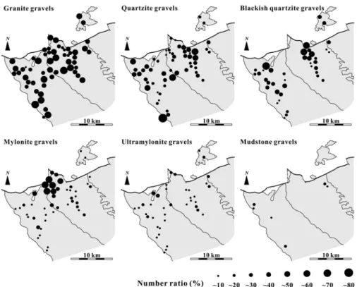
Figure 7 illustrates the compositional variation of con- glomerates. The granite gravels are most dominant and uni- form in composition ratio as a whole (mostly 40 to 80%),
whereas the conglomerate composition of other gravels is heterogeneous. The quartzite gravels show much fluctuated composition ratios (10 to 80%). The blackish quartzite gravels densely occur in NWN-trending elongated areas in the Nagdong and Hasandong formations (30 to 60%), and display a decreasing-southeastward trend in ratio (0 to 40%). The mylonite gravels are very highly dense (40 to 70%) in and around Yangseo-ri, the northern margin of the Hasandong Formation, while at other sites show low ratios (0 to 30%). The ultramylonite gravels are of low ratios at all sites (0 to 30%) but show a slightly decreasing-southeast- ward trend in ratio. The mudstone gravels are sporadic and of lowest ratios (0 to 20%).
4.3. Gravel Size Distribution
Gravel sizes were analyzed and plotted from the mea- surement of the long axes of gravels from each lithologic type of gravels at each outcrop, and was classified into maximum sizes, measured from the largest gravel in each lithologic type of gravels at each outcrop, and into average sizes, measured from the average value of the random- selected 10 to 15 gravels from each lithologic type of grav- els. The gravels of granite, quartzite, blackish quartzite, mylo- nite, ultramylonite, and mudstone are 90, 33, 35, 115, 57, and 40 cm in maximum size, respectively.
The size distribution of each lithologic type of gravels is shown in Figure 8. The maximum- and average-size distri- butions of gravels generally display a fining-southward to southeastward variation, although all kinds of gravels show
Fig. 7. Map showing regional variation of the number ratios of conglomerate composition in the northern part of the Sindong Group.
individual gravel-size variations. Among the six types of grav- els, it is characteristic of the gravels of mylonite to be extremely large in size in and around Yangseo-ri, while invariable at other sites.
4.4. Interpretation
4.4.1. Inferred Provenance
The gravel size variation is well match to the pale-
Fig. 8. Map showing the maximum (A) and average (B) gravel-size distri- butions in the northern part of the Sin- dong Group. The maximum gravel- sizes were selected from the largest gravel per each kind of gravels, whereas the average gravel-sizes were randomly selected from 10 gravels per each lithologic kind of gravels.
Structural and provenance analyses of the Homyeong Fault 259
ocurrent direction from the north and northwest of the Sindong Group reported by Rhee et al. (1998). Petro- logical similarity was examined between the gravels in the northern part of the Sindong Group and the pre-Cre- taceous basement rocks to the north of the Sindong Group, as follows.
Granite gravels
Thegranite gravels are roughly subdivided into two types, biotite granite and microcline granite gravels. The biotite granite in the gravels has the mineral composition and tex- ture very similar to the Precambrian granitic gneissose, whereas the microcline granite in the gravels is mineralog- ically and texturally close resemblance to the microcline granite of the Hamchang Granite. No gravels of diorite and tonalite are observed, and hence the Jurassic Yeongju Gran- ite cannot be regarded as the source rock of the granite grav- els. In short, it is suggested that the provenance of the granite gravels corresponds to the granitic gneissose and Hamchang Granite.
Quartzite gravels
The whitish metaquartzite in the gravels near-perfectly resemble the metaquartzite of the Weonnam Group in terms of mineral composition and texture.
Blackish quartzite gravels
The provenance of the blackish quartzite gravels cannot be estimated in this study, because no outcrops of the black- ish quartzite were found in the basement rocks around the Sindong Group. There are three probable reasons: (1) the outcrops were just not found because the blackish quartzite does not occur widely, (2) the blackish quartzite occurs out of the study area, or (3) the blackish quartzite now cannot be found because of complete erosion. It can also be thought that the metaquartzite of the Weonnam Group had been metamorphosed into the blackish quartzite, because the black- ish quartzite, which mainly comprises quartz, looks like the metaquartzite in the gravels, and include metamorphic min- erals such as rutile, titanite, and kyanite which are absent in the quartzite gravels. Anyway, we cannot choose an answer from the foregoing probable reasons in this paper, and a fur- ther detailed study is needed.
Mylonite and ultramylonite gravels
Both the mineral composition and texture of the mylonite and ultramylonite in the gravels are very close to those of the mylonite and ultramylonite of the Yecheon Shear Zone, respectively. Thus, it is very likely that the mylonite and ultramylonite gravels were derived from the mylonitic rocks of the Yecheon Shear Zone. In this way, these gravels strongly indicate that the Yecheon Shear Zone had already been cropped out on the Earth’s surface before the deposi- tion of the Sindong Group.
Mudstone gravels
The mudstone gravels are rarely included in the conglom- erate beds in the study area. The mudstone gravels in the Nagdong Formation comprise the blackish mudstone grav- els, whereas the reddish mudstone gravels are included in the Hasandong Formation. The Nagdong formation includes black shales, while the Hasandong Formation is rich in red- dish mudstones. Angular shape of the mudstone gravels implies that during deposition of the mudstone gravels the mudstones had been consolidated almost completely. Thus, it is regarded that the mudstone gravels are probably rip-up clasts derived from the mudstones of the Sindong Group.
4.4.2. Paleogeology of the Provenance
The foregoing interpretation suggests that the gravels were mostly derived from the Yecheon Shear Zone and its vicinity. The conspicuous points of our provenance study are that (1) a large number of mylonite boulders presum- ably supplied from the mylonitic rocks of the Yecheon Shear Zone occur in the northern margin of the Sindong Group, and (2) no gravels derived from the diorite and tonalite of the Yeongju Granite body are observed in spite of its wide distribution immediately adjacent to the Yecheon Shear Zone.
One of the critical points for provenance study is that the basement rocks, underlying the basin-fill deposits at present, cannot always be considered as the all probable source rocks of the basin-fill deposits; for the basin-fill deposits are indicative of the composition of the ancient basement rocks that may have been eroded out since then. This paper, how- ever, revealed that the composition of gravels in the north- ern part of the Sindong Group is very close to that of the pre-Cretaceous basement rocks on the north of the Sindong Group. This fact implies that the basement-rock association at present is almost similar with that at the depositional stage of the Sindong Group.
On the other hand, there is a possibility that the Yeongju Granite body had not been still cropped out at the deposi- tional stage of the Sindong Group because of no gravels of diorite and tonalite probably derived from the Yeongju Granite body immediately nearby the Yecheon Shear Zone.
Hong (2001) has carried out a geobarometric study of the Yeongju Granite body with a hornblende-plagioclase geo- thermometer, and estimated the pressure of emplacement of the granite body to be 7 kb in average, which means about 25 km in depth. From the gravels of mylonite and ultramy- lonite presumably derived from the Yecheon Shear Zone, the Yecheon Shear Zone is considered to have been partly cropped out to the surface at the depositional stage of the Sindong Group. Mylonitic rock forms at a deeper level than a cataclastic-plastic transition zone, which lies on approxi- mately 10 to 15 km in depth. On the assumption that the basement rocks up to about 15 km in depth had been eroded out prior to the deposition of the Sindong Group, the ero-
sion of the basement rocks of more 10 km in thickness is needed to reach the estimated 25 km in depth of the Yeo- ngju Granite body observed at present. Even though the Yeongju Granite body had been cropped out before the for- mation of the Nagdong Trough, it is questionable that the Yeongju Granite body close to the Yecheon Shear Zone did not supply any gravels to the Nagdong Trough. Hence, we interpret that the Yeongju Granite body had not been yet cropped out at the deposition of the Sindong Group (Fig. 9).
5. DISCUSSION
5.1. Reactivation of the Yecheon Shear Zone
The Homyeong Fault, newly defined in this study, runs on the Yecheon Shear Zone, and consists of sinistral cata- clasite including the mylonite fragments derived from the dextral Yecheon Shear Zone. This strongly suggests that the
of the Yecheon Shear Zone occurred at the depositional stage of the Gyeongsang Supergroup.
The conglomerate provenance analyzed in this study reveals that most of the gravels in the northern part of the Sindong Group were very likely derived from the Yecheon Shear Zone and its vicinity. Note that no strata of the Gyeo- ngsang Supergroup occur to the north of the Yecheon Shear Zone at present. This suggests that the Sindong Group was probably deposited on the south of the Yecheon Shear Zone, indicating that the northern margin of the Nagdong Trough was located along the Yecheon Shear Zone.
With respect to the northern margin of the Nagdong Trough, Chang (1977) suggested that the Nagdong Trough had the northern fault margin that had been active during the for- mation of the Nagdong Trough. His suggestion is strongly supported by thick alluvial-fan conglomerate with a debris- flow deposit in the northern margin of the Sindong Group, which shows a vertical growth of clast wedges (Rhee et al., 1998). In general, thick alluvial-fan conglomerate implies rapid rate of sedimentation. This requires the basin to be rapidly subsided for making its accommodation space. Therefore, alluvial-fan conglomerate wedge is vertically banked against an active faulted margin of the basin, indicating syndepo- sitional faulting at the basin margin (Einsele, 1992). The syndepositional faulting supplies coarse sediments to the subsided basin from the nearby uplifted rocks. Because proximal facies flanked with the fault gets much coarser and thicker than distal facies, subsequent subsidence caused by sediment loading is inevitably differential in rate between them. The thickening-northward wedge geometry of the Sindong Group (Chang, 1977; Choi et al., 1982) implies the thick-sediment-loaded subsidence in proximal part. Thus, it can be judged that this geometry was formed after the dep- osition of the Sindong Group, that is, present-day wedge geometry does not directly reflect the basin geometry itself at the deposition. That is why the paleocurrent analyses show not the northward- but the southward-directed sedi- ment dispersals (Chang and Kim, 1968; Rhee et al., 1998).
The foregoing reasons lead us to the conclusion that the fault reactivation on the pre-existing shear zone caused the
Fig. 9. Evolution of the Nagdong Trough in the Yecheon–Euiseong area. (A) Before the deposition of the Sindong Group. (B) Depo- sitional stage of the Nagdong Formation with the major faulting of the Andong Fault. (C) Depositional stage of the Hasandong For- mation with the major faulting of the Homyeong Fault. No scale.
Large arrows indicate the fault sense.
Structural and provenance analyses of the Homyeong Fault 261
nearby basement rocks, namely the Yecheon Shear Zone and its vicinity, to be deposited as gravels to the Nagdong Trough on the south of the fault. We argue that the Homy- eong Fault was active in the Early Cretaceous and played a role of a northern boundary fault of the Nagdong Trough.
The age of the Sindong Group is speculated to be Bar- remian to early Aptian (Chang and Park, 2003), and the Homyeong Fault is, thus, regarded to have been formed in Barremian to early Aptian coevally with deposition of the Sindong Group. While this study provides an estimate of the age of formation of the Homyeong Fault, its activity during the depositional stage of the Hayang Group can not be ascertained because the fault has been found on the north of the Sindong Group only. Since it appears to exist on the north of the Hayang Group, it is necessary to clarify the dis- tribution of the Homyeong Fault in order to understand the formation of the Gyeongsang Basin.
5.2. Back-Faulting Model of the Nagdong Trough Some workers have regarded that the Andong Fault was the northern boundary fault of the Nagdong Trough during its formation (e.g., Choi et al., 1982, 2002; Chough et al., 2000), while we agree with Chang’s (1977) interpretation that the Andong Fault was not its boundary fault, based on the facts that the Andong Fault is located to the south of the Homy- eong Fault, and that the conglomerate provenance analyzed in this study is inferred to be the basement rocks close not to the Andong Fault but to the Homyeong Fault.
It is noteworthy that not the Nagdong Formation but the Hasandong Formation occurs to the north of the Andong Fault and unconformably covers the basement rocks. This indicates non-deposition of the Nagdong Formation to the north of the Andong Fault (Choi et al., 2002), in other words, non- or minor activity of the Homyeong Fault at its deposition. This is also supported by the facts that the degree of rock fragmentation in the fault tends to be weaker westward and the western extension of the Homyeong Fault is unclear to the north of the Nagdong Formation. Inferring from the extremely large boulders of mylonite deposited predominantly in the northern margin of the Hasandong Formation, the Homyeong Fault was presumably active as a major fault at the depositional stage of the Hasandong Formation. In this way, there is a possibility that the Andong Fault was already active at the deposition of the Nagdong Formation, although no outcrop has been described so far that the Andong Fault to the south of the Homyeong Fault has a normal-fault component dipping basinward.
Two fining-upward cycles of sedimentation are recog- nized in the Sindong Group (Chang, 1977): the first cycle corresponds to the Nagdong Formation, and the second one does to the Hasandong and Jinju formations. It therefore seems likely that related major faulting was different between the deposition of the Nagdong and Hasandong formations,
that is, the former was closely associated with the activity of the Andong Fault and the latter was with that of the Homyeong Fault (Fig. 9). This style of basin margin fault- ing is termed ‘back-faulting’ that the next major faulting at the basin margin occurs to the backside of the pre-forming fault and results in the next sedimentation cycle (Heward, 1978). In this faulting pattern, no accommodation space of the Nagdong Formation would be formed to the north of the Andong Fault, which is consistent with its present distribu- tion (Chang, 1977; Yoon et al., 1988). We need to take fur- ther detailed research for demonstrating our model.
6. SUMMARY AND CONCLUSIONS
In the northwestern part of North Gyeongsang Province, the basement rocks consist of the Precambrian granitic gneissose, Hamchang Granite, and Weonnam Group, and of the Jurassic Yeongju Granite. They are dextrally mylonitized by the Jurassic Yecheon Shear Zone, and are unconform- ably covered by the Cretaceous Sindong Group. The con- glomerates of the northern part of the Sindong Group include gravels of granite, metaquartzite, blackish quartzite, mylo- nite, ultramylonite, and mudstone. Petrological comparison between the gravels and basement rocks suggests that most of the gravels observed in the northern part of the Sindong Group were very likely derived from the pre-Cretaceous basement rocks in and around the Yecheon Shear Zone.
The steeply southward-dipping Homyeong Fault occurs on the Jurassic Yecheon Shear Zone. The Homyeong Fault contains cataclastically-fractured rock derived from the mylonitic rocks of the Yecheon Shear Zone, which shows sinistral- and normal-fault components. This implies that the sinistral cataclasis has occurred after the Jurassic dextral mylonitization. Because of the Korean Cretaceous strike-slip basins formed by reactivation of the Jurassic HSSD, the grav- els are supposed to be an indicator of reactivation of the Yecheon Shear Zone synchronous with the deposition of the Sindong Group. Hence the Homyeong Fault is interpreted to have been syndepositional with the Sindong Group as a north- ern boundary fault of the Nagdong Trough, inferring from combination of the cataclastic feature of the Homyeong Fault with the result of the provenance analysis of conglomerates.
The Homyeong Fault is supposed to have been active as a major fault at the depositional stage of not the Nagdong but Hasandong formations, based on the following reasons.
(1) No strata of the Nagdong Formation occur to the north of the Andong Fault, while the Hasandong Formation to its north covers the basement rocks with unconformity. (2) The Hasandong Formation in its northern margin includes a large number of boulders of mylonite. And (3) the catacla- site of the Homyeong Fault shows a variation of rock frag- mentation getting weaker westward, and its distribution is unclear to the north of the Nagdong Formation. In this way, it seems likely that the Andong Fault activity was closely
Chang, K.H. and Kim, H.M., 1968, Cretaceous Paleocurrent and Sedimentation in Northwestern Part of Gyeongsang Basin, South- ern Korea. Journal of the Geological Society of Korea, 4, 77–97.
Chang, K.H., 1975, Cretaceous stratigraphy of southeast Korea. Jour- nal of the Geological Society of Korea, 11, 1–23.
Chang, K.H., 1977, Late Mesozoic stratigraphy, sedimentology and tectonics of Southeastern Korea. Journal of the Geological Soci- ety of Korea, 13, 76–90. (in Korean).
Chang, K.-H. and Park, S.-O., 2003, Cretaceous stratigraphy of Korea and interregional correlations. Memoir of the Fukui Prefectural Dinosaur Museum, 2, 103–112.
Chang, T.W., 1990, Relative timing of shear zone formation and granite emplacement in the Yechon Shear Zone, Korea. Journal of the Korean Institute of Mining Geology, 23, 453–463.
Cho, K.-H., Takagi, H. and Suzuki, K., 1999, CHIME monazite age of granite rocks in the Sunchang shear zone, Korea: timing of dextral ductile shear. Geosciences Journal, 3, 1–15.
Choi, H.I., Son, J.D., Oh, J.H., Choi, Y.J., Yoon, H.S., Shin, S.C., Yang, M.Y., Kim, S.G., Cho, D.H., Moon, C.B., Min, S.S. and Park, Y.S., 1982, Geological, geochemical and gGeophysical studies on the Gyeongsang Supergroup in the Euiseong area.
KIER Bulletin-28, Korea Institute of Energy and Resources, 50 p. (in Korean with English abstract).
Choi, P.-Y., Lee, S.R., Choi, H.-I., Hwang, J.-H., Kwon, S.-K., Ko, I.-S.
and An, G.-O., 2002, Movement history of the Andong Fault System:
Geometric and tectonic approaches. Geosciences Journal, 6, 91–102.
Chough, S.K., Kwon, S.-T., Ree, J.-H. and Choi, D.K., 2000, Tectonic and sedimentary evolution of the Korean peninsula: a review and new view. Earth-Science Reviews, 52, 175–235.
Cluzel, D., 1992, Formation and tectonic evolution of early Mesozoic intramontane basins in the Ogcheon belt (South Korea): a reap- praisal of the Jurassic “Daebo orogeny”. Journal of Southeast Asian Earth Sciences, 7, 223–235.
Einsele, G., 1992, Sedimentary Basin: Evolution, Facies, and Sediment Budget. Springer-Verlag, 628 p.
Han, R., Ree, J.-H., Cho, D-.L., Kwon, S-.T. and Armstrong, R., 2006, SHRIMP U-Pb zircon ages of pyroclastic rocks in the Ban- song Group, Taebaeksan Basin, South Korea and their implica- tion for the Mesozoic tectonics. Gondwana Research, 9, 106–117.
Heward, A.P., 1978, Alluvial fan sequence and mega-sequence mod- els: with examples from Westphalian D–Stephanian B coalfields, northern Spain. In: Miall, A.D. (eds.), Fluvial Sedimentology, Cana- dian Society of Petroleum Geologists Memoir, 5, 669–702.
Hong, S.S., 2001, Implication for the emplacement depth of the gran-
Lee, D.S., eds., 1988, Geology of Korea (2nd Edition). Kyohak-Sa, Seoul, 514 p.
Lee, J.I., Jwa, Y.-J., Park, C.-H., Lee, M.J. and Moutte, J., 1998, Petrology and geochemistry of the Youngju and Andong granites in the northeastern Yeongnam Massif, Korea. Geosciences Jour- nal, Seoul, 2, 1–14.
Lee, J.I. and Lee, Y.I., 2001, Kübler illite crystallinity index of the Cretaceous Gyeongsang Basin, Korea: implications for basin evolution. Clays and Clay Minerals, 49, 36–43.
Lee, M.S. and Kim, S.W., 1968, Geological Report of the Hamchang Sheet (1:50,000). Geological Survey of Korea, 34 p.
Okada, H. and Sakai, T., 2000, The Cretaceous system of the Japa- nese islands and its physical environments. In: Okada, H. and Mateer, N.J. (eds.), Cretaceous Environments of Asia, Develop- ments in Palaeontology and Stratigraphy, 17, 113–144.
Otoh, S., Jwa, Y.-J. and Lee, M.-S., 1994, Late Mesozoic tectonic devel- opment of South Korea: Formation of the Honam strike-slip duplex and Cretaceous strike-slip basins. The Journal of Tectonic Research Group of Japan, 39, 237–249. (in Japanese with English abstract) Otoh, S., Jwa, Y.-J., Nomura, R. and Sakai, H., 1999, A preliminary
AMS (anisotropy of magnetic susceptibility) study of the Namwon granite, southwest Korea. Geosciences Journal, Seoul, 3, 31–41.
Otoh, S. and Yanai, S., 1996, Mesozoic inversive wrench tectonics in far east Asia: examples from Korea and Japan. In: Yin, A. and Harrison, T.M. (eds.), The Tectonic Evolution of Asia, Cambridge University Press, 401–419.
Reedman, A.J. and Um, S. H., 1975, The Geology of Korea. Geo- logical and Mineral Institute of Korea, Seoul, 139 p.
Rhee, C.W., Jo, H.R. and Chough, S.K., 1998, An allostratigraphic approach to a non-marine basin: the north-western part of Cre- taceous Kyongsang Basin, SE Korea. Sedimentology, 45, 449–472.
Sagong, H., Kwon, S.-T. and Ree, J.-H., 2005, Mesozoic episodic magmatism in South Korea and its tectonic implication. Tecton- ics, 24, TC5002.
Yoon, S.K., Cha, M.S., Kim, J.J. and Lee, J.T., 1988, Geological Report of the Yecheon Sheet (1:50,000). Geological Survey of Korea, 12 p.
Yanai, S., Park, B.-S. and Otoh, S., 1985, The Honam shear zone (South Korea): deformation and tectonic implication in the Far East. Scientific Papers of College of Arts and Sciences, Univer- sity of Tokyo, 35, 181–210.
Won, C.K. and Kim, K.T., 1969, Geological Report of the Sangju Sheet (1:50,000). Geological Survey of Korea, 34 p.
Manuscript received September 8, 2005 Manuscript accepted August 14, 2006