APPLYING ALOS PRISM DATA TO RETRIEVE THE ATMPSPHERIC TRANSMITTANCE
Gin-Rong Liu¹, Tang-Huang Lin, Fuan Tsai and Kuo-Kuang Li Center for Space and Remote Sensing Research, National Central University
Jhongli, Taiwan 320
1. Corresponding Author, Professor, Tel:(886)-3-4227151~57620, E-mail: [email protected]
ABSTRACT In this study, a new technique for atmospheric transmittance estimated from ALOS PRISM data is developed. It is based on satellite's observing radiances of different view angles and assumes that the cause of difference in radiances is the different view angles. The ALOS PRISM has three independent optical systems for viewing forward and backward and producing a stereoscopic image along the satellite's track. This stereo pair data can be used to estimate the transmittance according to the radiative transfer theory. This derived transmittance will be validated by the AERONET data and compared with the MODTRAN4 simulation results. Results show that the higher the land cover albedo, the better the derived transmittance compared to the AERONET data. Besides, this technique also shows the transmittance retrieval will be underestimated for the low land cover albedo.
KEY WORDS: Transmittance, ALOS PRISM, Radiative Transfer Equation 1. INTRODUCTION
Transmittance of the atmosphere indicates the turbidity of the sky. It changes day by day and affected by absorption and scattering of the atmospheric molecules and aerosols. Billions of aerosols suspend in the sky around the world each year and evidence suggests that these particles play a very important role in the severity of climate change. Moreover, how these tiny particles affect human health should be studied.(Pope et al., 1995). However the worldwide aerosols monitoring from ground stations (i.e. using sun photometer) seems important but can’t cover globally.
And the satellite data may be the best measurements to achieve this goal(Kaufman et al., 1990).
The Advanced Land Observing Satellite (ALOS) satellite was launched by Japan on 24 January 2006. One of the three sensors housed in this satellite is the Panchromatic ( 0.52~0.77μm ) Instrument for Stereo
Mapping (PRISM), which is comprised of three sets of optical systems with resolution 2.5mx2.5m to measure precise land elevation(JAXA, 2006). The PRISM can generate a stereoscopic image almost at the same time.
This observations can be the special characteristics for remote sensing the atmospheric transmittance based on the radiative transfer equation.
2. THEORETICAL BASIS
If the atmosphere situation can be assumed the same within a short period of time, the radiance difference observed from satellite due only to the satellite's different view angle(Figure 1). The radiative transfer equation including path radiance can be written in equation(1).
Figure 1. Demonstration of satellite observed radiances.
( )
Dm F
* F
Fλ θ1 = λ0 τλ1+ λ (1)
where λ =wavelength
( )0
Fλ =radiance at nadir
( )θ1
Fλ =satellite radiance viewed at θ1
( )θ2
Fλ =satellite radiance viewed at θ 2
λ0
F =radiance reflected by the surface τ =transmittance
FλD=path radiance
Satellite measurements in different incidence angles can be written as Equation(2)and(3).
( )
1 0 11
D
m F
* F
Fλθ = λ τλ + λ (2)
( )
2 0 22
D
m F
* F
Fλ θ = λ τλ + λ (3)
where m1=sec( )θ1 , m2 =sec( )θ2
Solving forτ ,
⎟⎟
⎠
⎞
⎜⎜
⎝
⎛
⎟⎟⎠
⎜⎜ ⎞
⎝
⎛
−
= −
2 2
1 1 2
1 ( )
) ( ) - (
1
D D
F F
F ln F
m exp m
λ λ
λ λ
θ
τ θ (4)
Whenever the unknown FλD in equation(4)is obtained from MODTRAN4, then the transmittance τ is known.
3. OBSERVATIONS AND RETRIEVAL RESULTS
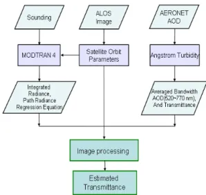
In this study, the transmittance is retrieved on 10 Oct., 2006 in Taoyuan and Hsinchu of Taiwan, respectively.
The sounding data in Banciao where locate on northern Taiwan are ingested in MODTRAN4 simulation. The AERONET data(sun photometer)measured on National Central University ( NCU ) are applied in
m o agstr
Ao && turbidity formula (Iqbal,1983)to estimate the
transmittance for validation. The procedure is illustrated in Fig. 2.
Figure 2. Illustration of the of the atmospheric transmittance retrieval procedure.
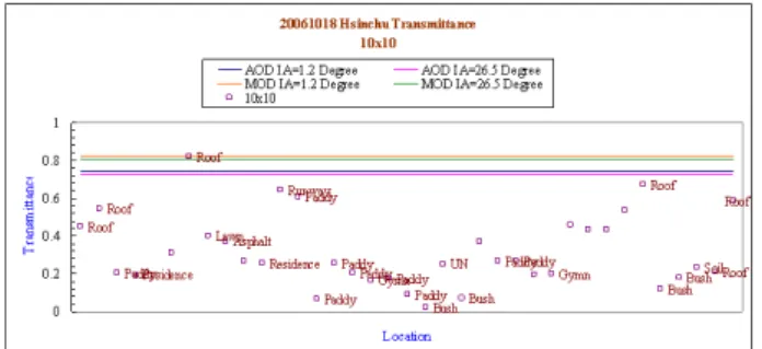
In MODTRAN4, the visibility is assumed 50 km for clear day (Liang et al., 2002)and is validated by the sun photometer data. The MODTRAN4 estimations for PRISM at nadir 1.2o and forward 26.5o are 0.8246 and 0.8067, respectively. However, the transmittance of the same incidence angle calculated by the sun photometer is 0.7476 and 0.725. These two results are not in small difference. The sun photometer measurements are the real time atmosphere observations, so it is used as a standard to evaluate the results of this study and the MODTRAN4 calculations. Different land covers from low to high albedo are investigated in this study. The derived results are shown in Fig. 3 and 4. The category of land covers are labeled on the right of the points and no labeled means the land cover can't be identified by the satellite image. The upper two lines in each figure are simulated by MODTRAN4 at 1.2o and 26.5o and the
lower two lines are calculated by the sun photometer measurements with the same incidence angle. The window size for each land cover is 10x10 pixels.
Figure 3. Derived transmittance in Hsinchu
Figure 4. Derived transmittances in Taoyuan
In Fig. 3 the transmittances derived by this study for lower albedo land cover (e.g. paddy, bush…) is under estimated in comparing with those measured by the sun photometer, but for the higher albedo land covers (e.g.
roof ) this new technique shows more stable in estimating the transmittances. Fig. 4 shows the same results as Fig. 3 but for Taoyuan area. The estimated transmittance of this study for the lower albedo land covers still underestimated and those of the higher albedo land covers are almost close to the sun photometer's results, especially for the roof near NCU where the sun photometer is located. The MODTRAN4 simulations and sun photometer estimations are based on the data observed in NCU of Taoyuan, so the transmittance difference in Hsinchu where is 20 to 30km away from Taoyuan may be acceptable for higher albedo roof. According to this study the radiance of the roof is greater than 70W/m2/sr/μm and this will make sure the
derived transmittance will not be too small.
4. DISCUSSIONS
The proposed using different satellite view angles for transmittance derivation in this study is applied from lower albedo land covers to the higher. This new technique shows it is not suitable for lower albedo land covers, but good for higher albedo land covers . In general, the roof is the best land cover sample used to estimate the atmospheric transmittance for this algorithm.
And if the observed radiance is over 112W/m2/sr/μm for the land cover sample, the derived transmittance will close to the sun photometer’s measurement. But if the land cover albedo is low, the observed radiance is very easy contaminated by the aerosols in contrast to the high one. This will make the difference of different view angles’ observed radiances too small to calculate accurate transmittance.
ACKNOWLEDGEMENTS
This study was primarily supported by the National Science Council (grand No.: NSC 95-2752-M-008-005 -PAE) of Taiwan. The authors thank CSRSR/NCU Taiwan and AERONET for their data providing.
REFERENCES m o ngstr
Ao && A.K., 1929 : On the atmospheric
transmission of sun radiation and on dust in the air.
Geography Annals, 11, pp. 165-166.
Iqbal, Muhammad, 1983: An Introduction to Solar Radiation, Academic Press, Canada, pp. 107-123.
JAXA, 2006:ALOS/PRISM Level 1 product format description revision J (ALOS-DPFT-E01), Earth Observation Research Center, Japan, pp. 88.
Kaufman, Y.J., Fraser, R.S., Ferrare, R.A., 1990. Satellite measurements of large-scale air pollution methods. J.
Geophys. Res. 95 (D7), pp. 9895-9909.
Liang, S., H. Fang and M. Chen, 2002: Atmospheric correction of Landsat ETM+ land surface imagery-Part 1:
Methods, IEEE Transaction on Geoscience and Remote Sensing, 39(11), pp. 2490-2498.
Pope, A.C., Thun, M.J., Namboodir, M.M., Dockery, D.W., Evans, J.S., Spezer, F.E. et al., 1995. Particulate air pollution as a predicator of mortality in a prospective study of US adults. Am. J. Resp. Crit. Care Med. 151, pp.
669-674.