교통위반 단속을 위한 고속도로 드론 패트롤 네트워크의 토폴로지 및 성능분석
조준모*
Highway Drone Patrol Network Topology and Performance Analysis for Traffic Violation Enforcement
Jun-Mo Jo*
요 약
2016년 이후부터 경찰당국에서는 드론을 활용하여 고속도로 상에서의 교통위반 차량을 단속하기 시작했다. 경찰은 교통 혼잡이 야기되는 시간이나 시즌에 갓길을 사용하거나 음주운전, 난폭운전 등의 차량들을 감시한다. 지금까지는 30분 단위로 단속을 하는 ‘스팟 이동식’ 방식을 사용하고 있다. 그러나, 이러한 방식은 많은 경찰인력이 각각의 드론을 충전하고 데이터 를 수동으로 수집 및 분석해야하는 번거로움이 있기 때문에 매우 비효율적인 방식이다. 따라서, 본 논문에서는 다수의 드론 을 무선망으로 연결하여 넓은 지역의 고속도로 상에서 적은인력으로 효과적으로 관리할 수 있는 시스템을 제안한다. 이를 위해 효율적인 드론 패트롤 네트워크 시스템의 토폴로지를 OPNET 시뮬레이터로 디자인하고 성능을 평가하였다.
ABSTRACT
Since year 2016, in Korea, the police department started to use drones to patrol violated vehicles on the highway area. They monitor vehicle drivers who use side ways on the highway during traffic congested hours of the season, drunken drivers, or violent drivers. They use the ‘Spot Mobility’ method which floats the drones for 30 minute period. However, this method is inefficient since it requires manually charging batteries, gathering data, and operate drones with many numbers of policeman. Therefore, in this paper, for the efficient patrol in this purpose, I have suggested an effectively manageable network system consists of many drones as the wireless network nodes and with small numbers of policeman in a wide highway area. To accomplish this, the two topologies of effective drone patrol network systems are designed and simulated in OPNET simulator for performance evaluation.
키워드
Drone Patrol, Network Topology, Network Performance Evaluation 드론 패트롤, 네트워크 토폴로지, 망성능 평가
* 교신저자 : 동명대학교 전자공학과 ㆍ접 수 일 : 2017. 08. 10 ㆍ수정완료일 : 2017. 10. 12 ㆍ게재확정일 : 2017. 12. 15
ㆍReceived : Aug 10, 2017, Revised : Oct 12, 2017, Accepted : Dec 15, 2017 ㆍCorresponding Author : Jun-Mo Jo
Dept. of Electronic Engineering, TongMyong University, Email : [email protected]
Ⅰ. Introduction
In Korea, the police department started to use drones to patrol violated vehicles on the highway area since may of 2016. They monitors vehicles
which use side ways on the highway during traffic jam hours in summer vacation season. Drones equipped with one or more electrical motors and a fixed-angle camera targeting on the ground. The drones are able to identify static or mobile ground http://dx.doi.org/10.13067/JKIECS.2017.12.6.1043
targets, which are considered as points that have to be monitored.
The drones need to have autonomous functions.
The policeman could control the drones, but many drones are required for the wide area of the highway. So the drones need to be installed autonomous functions in the system. The vehicles as drone is an important study subjects in these days[1].
Recent developments in wireless communication technologies, energy storage, computing power and Unmanned Aerial Vehicles(UAV) make a system composed of Wireless Sensor Networks(WSN) and multi-UAV the perfect candidate to play an important role in the disaster management. The response time of search and rescue personnel in a natural disaster is the key for saving the lives of those in the affected areas[2].
And also monitoring vehicular or UAV related issues are studied these days. There is a study related on the scientometric analysis through paper analysis of each organization and author to decide research direction for autonomous driving vehicles.
They have confirmed research trend of autonomous driving vehicle by using number of papers[3-4].
Conventional border patrol system consists of security checkpoints and border troops. To monitor the border in real-time with high accuracy and minimize the need for human support, a new border patrol system framework based on hybrid wireless sensor networks, which can accurately detect and track the border intrusion with minimum human involvements[5].
The fundamental variables for the analysis of traffic congestion are density, capacity and traffic flow. That should be able to analyze and simulate the instantaneous movement of each vehicle present on the road[6].
A communication relay is also important factor to performance evaluation. But with the advent of light weight, robust and autonomous platforms can
now perform this relay mission. UAV communication relay is intended to replace the legacy radios currently being used on tactical size UAVs such as Predator[7].
For the remote control of the vehicle or monitoring, the Controller Area Network (CAN) can be used for the application. The CAN is a contention-based serial communication bus with high performance, high speed, high reliability, and low cost for distributed real-time control applications[8].
In this paper, a drone communication network topology for the highway patrol is designed and simulated in the OPNET simulator. In section II, a drone wireless environment including network constraints are elaborated. And, in section III, the suggested drone patrol network topology is shown and explained in detail. Then in section IV, the simulation result of the topology is analyzed with a network topology. Finally, the conclusion is made in section V.
Ⅱ. Drone Wireless Network Environment
To patrol on a wide area of traffic jammed highway with many drones can be susceptible to electronic breakdown and even damage. In these cases, the failure of nodes not only could degrade the coverage quality of the monitored area, but also break some communication paths among nodes.
Example application scenarios include the deployment of a network to serve patrol of a vast border. In the case of a wireless network, when only a single node is lost, the effect on the network connectivity is minimal unless the failed node serves as a cut vertex. In the topology causing the network to be split to disjoint segments. However, a recovery process is ineffective in case the scope of failure involves multiple collocated nodes. Published schemes for overcoming the simultaneous failure of multiple
collocated nodes mostly pursue centralized recovery strategies.
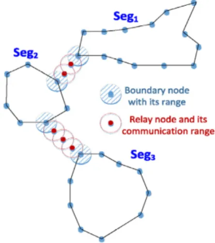
The Fig. 1 illustrates the dramatic effect of segment size and shape on the relay count required for establishing connectivity. A circle denotes the relay communication range. The links between segments reflect the solution while factoring in the boundary nodes, where a total of 5 relays will be needed. Note that Seg 2 has two interface points.
Seg 1 and Seg 3 are connected through a path that uses all new relay nodes and leverage the inter-segment links of Seg 2 Obviously using a single interface point in this case is a costly solution[9].
Fig. 1 Inter-Segments drone communication network
Ⅲ. Drone Patrol Network Topology
For the Static and Mobile Drone Location Problems, it need to apply a mathematically formula.
In order to describe the mathematical model to represent the optimal static or mobile drone location problem, it is useful to introduce the following notations and definitions. The flying zone is represented as a parallel piped of height hmax. The target detection above hmax is not possible and the machines are not allowed to fly beyond this
threshold. The projection of the whole flying region is represented by a rectangle with length xmax and width ymax. There are a points (x, y, h) where the drones could be located. It is worth observing that the targets assume arbitrary positions in the terrain of dimension (xmax × ymax).
Let U denote the set of available machines and T be thesetof targets to be monitored. It is assumed that each target ti∈T is characterized by its coordinates (Xti, Yti). Given a drone u located at point (xu, yu, hu). and the target ti, we define the distance between u and ti when h=0 with
.
Each drone u has avisibility θ that is represented by a disk in the plane (x, y) with radius which depends on hu. The higher the component hu, the longer the radius. The visibility depends on the angle of the camera lens[10].
The topology of the drone patrol network on highway consists of 3 sections similar principle to the Fig. 1. Each section could have many drones and mobility patterns. However, if there are too many drones, then it needs more numbers of the policeman to care the drones.
Table 1. Wireless LAN parameters
Attributes Value
Data Rate 11 Mbps
Transmit Power 0.001 W
Packet Reception Power -95 W
Physical Characteristics Direct Sequence
So the mobile nodes in the network considered as patrol drones set as shown in the Table 1 and Table 2. The Table 1 shows the specification of the wireless LAN parameters.
Table 2. Random waypoint parameters
Attributes Value
Speed (meters/sec) uniform_int(0, 10) Pause Time (sec) constant(20) Start Time (sec) constant(10) Record Trajectory Enabled
The Table 2 is characteristic of drone mobility.
Their speed, start time, and pause time are set as probabilistic manner shown in the table. the suggested each section has 8 drones to patrol.
There are two big types of mobility pattern for the network topology. One is the ‘Straight Many’
that have 4 drones to cover the upper bounded direction, and the other 4 drones cover lower bounded direction. So they are lined up in each direction shown in Fig. 2. Each node has their own trajectories and gradually follows up the adjacent node. The trajectories are straight lines as the road lined up ether upper direction or lower direction. If the node gets to the end of the their boundary borders they change their directions to the opposite direction. So they move back and forth repeatedly until the end of the simulation.
Fig. 2 ‘Straight Many’ topology network
The second topology, ‘Random Many’, of the 8 drones have random mobilities in the same size of the area. The 8 patrol drones cover 500m wide, 1km long roads. There are total of 3km long roads since
there are 3 sections of the network area. Only the center of the section has a server that gathers patrol data from 3 sections in real time.
Fig. 3 ‘Random Many’ topology network
IV. Simulation Result and Analysis
For the simulation and analysis of this topology, the random mobility of drone network is also designed and simulated. The simulation parameters selected for the global network of the performance evaluation are delay, load, number of retransmission attempts, and throughput of the wireless LAN.
However, for the conclusion, the critical parameters will be shown shortly. The simulation time is total of 10 minutes.
The the network topology and the simulation is operated in two big issues. One is which performs better between the ‘Straight’ and ‘Random’ mobility.
The other is how many drones are appropriate for this environment.
To start with the first aspect, the throughput for global network is shown in Fig. 4. The ‘Random Many’ topology performed better than the ‘Straight Many’.
Fig. 4 Throughput of Straight and Random Mobility
Fig. 5 also shows the ‘RandMany’ topology performed better than the ‘StraightMany’.
Fig. 5 Delay of Straight and Random Mobility
I finally conclude that the Random mobility showed better performance than the Straight one.
However, I wondered how many numbers of drones are appropriate for the network environment.
So I have made three other different Random mobility toplogies with different numbers of drones-‘RandMany’, ‘RandMid’, ‘RandFew’. The
‘RandMany’ has 8 drones, the ‘RandMid’ has 5 drones, and the ‘RandFew’ has 2 drones.
Fig. 6 shows that the ‘RandMid’ performed
highest record than the ‘RandMany’. The
‘RandFew’ had few chance to have encounter the adjacent nodes so it is often degraded performance.
Fig. 6 Throughput Comparison
Fig. 7 shows the retransmission attempts of Straight and Random Mobility. In the retransmission attempts parameter, also shows that the ‘RandMid’
has better performance than the ‘RandMany’ since the ‘RandMany’ has lots of data to retransmit.
Fig. 7 Retransmission Attempts Comparison
Unexpectedly, the result showed that the random mobility showed better than the straight one. And, the appropriate numbers of drones in this environment is 5 drones in each section with
random mobility. This result is considered as a real world scale since this network topology is simulated in the OPNET simulator.
V. Conclusion
Several drone patrol network topologies are designed and simulated in OPNET simulator. There are two big categories, ‘Straight’ and ‘Random’
mobility those are depend on the way of moving trajectory policies flying on the highway area. I have assumed that the ‘Straight’ mobility performs better than the ‘Random’, however, the result showed that the ‘Random’ mobility showed better performance in every aspects such as throughput, delay, retransmission attempts and so on. For the further study, the suggested topology in this paper with various routing protocols will be designed and simulated for examining the best suitable routing protocol in this environment.
References
[1] D. Fagnant and K. Kockelman, “The travel and environmental implications of shared autonomous vehicles, using agent based model scenarios,” Transportation Research Part C, vol. 40, no. 4, 2014, pp. 1-13.
[2] M. Erdelj, M. Krol, and E. Natalizio,
“Wireless Sensor Networks and Multi-UAV systems for natural disaster management,”
Computer Networks, Elsevier, vol. 124, no. 6, 2017, pp. 72-86.
[3] S. Yun, H. Son, and Y. Rhee, “A Study of Head Up Display System for Next Generation Vehicle,” J. of the Korea Institute of Electronic Communication Sciences, vol. 6, no. 3, 2011, pp.
439–444.
[4] J. Park, J. Choi, and Y. Bae, “Scientometric Analysis of Autonomous Vehicle through Paper Analysis of each Nation,” J. of the Korea Institute of Electronic Communication
Sciences, vol. 8, no. 2, 2013, pp. 321-328.
[5] Z. Sun, P. Wang, M. Vuran, A. Aldhelaan, and L. Akyildiz, “BorderSense: Border Patrol through advanced wireless senssor networks,”
Ad Hoc Networks 9, Elsevier, vol. 9, no. 3, 2011, pp. 468-477.
[6] G. Salvo, L. Caruso, and A. Scordo, “Urban traffic analysis through an UAV,” Procedia Social and Behavioral Sciences 111, Elsevier, vol.
111, no. 9, 2014, pp.532–539.
[7] S. Kim, H. Oh, J. Suk, and A. Tsourdos,
“Coordinated trajectory planning for efficient communication relay using multiple UAVs,”
Control Engineering Practice, Elsevier, vol. 29, no. 8, 2014, pp. 42-29.
[8] G. Cena, A. Valenzano, and S. Vitturi,
“Advances in automotive digital communications,” Computer Standards &
Interfaces, Elsevier, vol. 27, no. 6, 2005, pp. 665 –678.
[9] W. Lalouani, M. Younis, and N. Badache,
“Optimized repair of a partitioned network topology,” Computer Networks, Elsevier, vol. 22, no. 7, 2017, pp. 1-15.
[10] D. Zorbas, L. Pugliese, T. Razafindralambo, and F. Guerriero, “Optimal drone placement and cost-efficient target coverage,” J. of Network and Computer Applications, Elsevier, vol. 75, no. 10, 2016, pp. 16-31.
Author
조준모(Jun-Mo Jo) 1991년 아이오아주립대학교 컴퓨 터과학과 졸업 (공학사)
1995년 경북대학교 대학원 컴퓨터 공학과 졸업(공학석사)
2004년 경북대학교 대학원 컴퓨터공학과 졸업(공학 박사)
1998년~현재 동명대학교 전자공학과 교수
※ 관심분야 : 이동통신, 뇌파통신, 인공지능