770
F
ORESTS
OCIETYGeographic Information System Based Floral and Faunal Assessment of Alapang Communal Forest of Benguet, Philippines
Roscinto Ian C. Lumbres
1,2, Jennifer A. Palaganas
2, Sheryll C. Micosa
2, Elvira D. Besic
2, Kenneth A. Laruan
2, Chung Weon Yun
1, and Young Jin Lee
1*1Department of Forest Resources, Kongju National University, Yesan, Chungnam 340-802, Korea
2College of Forestry- Benguet State University, La Trinidad, Benguet, 2601, Philippines
Abstract :
This study was conducted to assess the existing flora and fauna, and to develop a spatial map of Alapang communal forest located in the province of Benguet, Philippines. A total of 52 species belonging to 27 families were identified during the inventory in this communal forest using the quadrat method while a total of 30 species belonging to 18 families were recorded using line intercept technique for the assessment of grasses, herbs, vines and other low-lying vegetation. The diversity index of the species in Alapang communal forests using the quadrat method was 2.6649 while for the line intercept technique it was 2.5446. The most dominant species in this area was found to be
Pinus kesiyaRoyle ex Gordon (Benguet pine) under Family Pinaceae with an importance value of 106.74%. In the faunal assessment, four species of birds and a small mammal particularly a rodent were identified during the study.
Aside from the high species diversity of this communal forest, the presence of endemic and indicator species in the area denotes that this forest was still in good condition hence must be protected. Spatial maps and database system were generated based from data gathered in the field using Geographic Information System (GIS).
Key words :Alapang communal forests, Pinus kesiya, diversity index, GIS
Introduction
High biodiversity abounds in different biogeographic regions of the Philippines. In this country, there are 15 biogeographic zones in which Cordillera Administrative Region(CAR) is included and where Alapang communal forest is located(DENR-UNEP, 1997 as cited by Bacudo,
et al., 2006). These biogeographic zones are created due to its richness in the biological resources particularly the flora and fauna. Species distribution varies from one loca- tion to another especially in tropical places because of biogeography, disturbance and habitat(Whitemore, 2003).
CAR is characterized by mountainous topography con- sisting of variety of flora and fauna that provides food, wood, fodder and shelter to its inhabitants. It also provides protective benefits against disastrous calamities like typhoon and is also responsible for the gentle climate of the region.
However, the diversity of the region’s resources seems not given enough attention and the extinction of important species has been going on unnoticed. The rate of loss of biodiversity in the country is higher anywhere else in the
world as a result of habitat destruction (PCSD-IEMSDP, 1998). Thus, there is an immediate need to address the growing and non-stop degradation of the environment so as to prevent biodiversity loss and extinction of different organisms. This gives local government an interest to create a plan and program for the management and pro- tection of these biological resources. Therefore, this study on assessing the flora and fauna is relevant and timely espe- cially no study yet has been conducted in this area.
According to Phillips
et al. (2003), it is necessary to conduct a floristic inventory in order to determine the species diversity and understand the species distribution.
The output will serve as the groundwork for monitoring of changes and designing appropriate strategies for the management of this forest for the stakeholders. More- over, this will serve as basis for policy formulation concern- ing the areas to which it may focus into the preservation and protection of the forests (Bacudo
et al., 2006).
The purpose of this study is to assess the existing flora and fauna in Alapang communal forest and develop a spatial map and database. It specifically aims to establish and generate information on the most dominant species of flora, determine the biodiversity index and identify the presence of endemic, threatened and endangered species.
*Corresponding author E-mail: [email protected]
Material and Methods
1. Study site
Barangay
Alapang is situated on a mountain slope on the central part of the municipality of La Trinidad at geographical coordinates of 16° 21'' latitude and 120°
25'' longitude. It is two kilometer from the Municipal Hall, seven kilometer from the city of Baguio and 252 kilo- meter Northeast of Manila.
The Department of Environment and Natural Resources (DENR) Cadastral survey shows that Alapang has a total land area of 201.22 hectare. Of the total area, 45.53% is agriculture, 36.74% forest, and 17.73% built up areas. It is the fifth smallest
barangayin La Trinidad municipality. It has five
sitiosnamely: Samoyao, Alapang Proper, Dapit- ing, Ettong, and Camp Dangwa.
Alapang is generally hilly to mountainous from gentle slopes to very steep slopes ranging from 18 to 30 degrees.
Elevation ranges from 900 to 1,400 meter above sea level.
The temperature in this
barangayranges from 6 to 20 degrees centigrade. The coldest months are from Decem- ber to February. It has two pronounced seasons. Rainy days are usually from May to September with August being the wettest month with an average rainfall of 1,000 mm and dry during the rest of the year.
Two types of soil exist in the
barangay, namely: loam and coarse loam. The so called Puguis gravelly loam and Benguet loam are found in the area and offers good to excessive drainage. External drainage is excessive while internal drainage is fair.
2. Data collection
In this study, combinations of qualitative and quanti- tative approach were performed. The quantitative part made use of vegetational analyses using mathematical formula on biodiversity indices, density, frequency, and dominance while qualitative approach covered the iden- tification of flora and fauna present in the area.
The information gathered in the field include the com- mon name, scientific name, and family name of each individual tree species; northing and easting coordinates of each tree and the four corners of each quadrat; and diameter at breast height in centimeter and total height in meter of each individual tree species.
The transect count/ time area method for avian fauna and the trapping method for small mammals were the two methods of faunal survey used in the field. Counting of bird species was done during the inventory through establishment of an imaginary transect line. Birds seen and heard during site visits were recorded. Nets and cage traps with bait were placed and left at strategic areas to study the small mammals living in the area. After pic- tures and other relevant information were taken, trapped
animals were released.
The primary data collected from Alapang communal forest were exported to the GIS software to show the locations of the trees and the quadrats. The boundary of
Barangay
Alapang was overlaid to the location of all the quadrats and trees. Editing was done in order to have accurate information and maps. New themes (polygon, line and point) were generated and these were boundary of
BarangayAlapang, location of three quadrats, loca- tion of all trees in each quadrat, and 30 meter buffer zone for the threatened and vulnerable species.
3. Data analysis
Vegetation analysis was used to analyze the data gathered. The importance value, dominance index and diversity index were computed. These information will provide a better index on the species importance and function in its habitat than the density alone. The rank or order for a particular species within the forest community can be determined and quantified (Kent and Coker, 1992;
Mueller-Dumbois and Ellenberg, 1974). Quadrat method was used in the assessment of trees, saplings and seedlings employing 10% sampling size. The number of quadrats laid out on the field was determined based from the reconnais- sance performed by the team. A total of three 50 m
×20 m plots were established in Alapang communal forests. All trees, saplings and seedlings that fell within the established quadrats were identified, counted and measured. Likewise grasses, herbs and ferns were assessed using the line inter- cept technique. This was done with the establishment of 150m transect lines along the established quadrats. The line was subdivided further into equal intervals of 20 meters.
Vegetation analyses were computed using the follow- ing formulae (Odum and Barett, 2005; Krebs, 1985)
Diversity indices and dominance index were also com- puted using the Shannon-Weiner and Simpson’s Index formula as follows:
Diversity index (Shannon-Weiner) Where:
H'= diversity index
Pi
= proportion of individual species i ln = natural logarithm.
Density D( ) No. of plants of a certain species Total area sample
--- 100×
=
Relative Dentisty RD( ) Density of a species Total density for all species --- 100×
=
Relative Frequency RF( ) Frequency value for a species=--- 100Total frequency all species ×
Relative Height RH( ) Height of a species Total height
--- 100×
=
Impor ce tan Value IV( )=RD RE RH+ +
H′=–
∑
pi ln piDominance Index (DI), (Simpson’s formula):
Where: DI = Dominance Index
Y = Importance of a given species N = Sum importance value of all species.
Results and Discussion 1. Floral assessment
In the quadrat method, a total of 52 species belonging to 27 families were identified during the inventory in Alapang communal forests. Most dominant families in the study site were Lamiaceae, Moraceae, Phyllanthaceae, Caprifoliaceae, Meliaceae, Myrsinaceae and Rubiaceae (Figure 1). While the dominant species was
Pinus kesiya(Benguet pine)
,a member of family Pinaceae with importance value of 106.74% and dominance index of .12659 (Table 1). This species was followed by
Melas- toma malabathricumand
Psidium guajavawith 17.07%
and .00324 and 16.39% and .00298 importance values and dominance index, respectively.
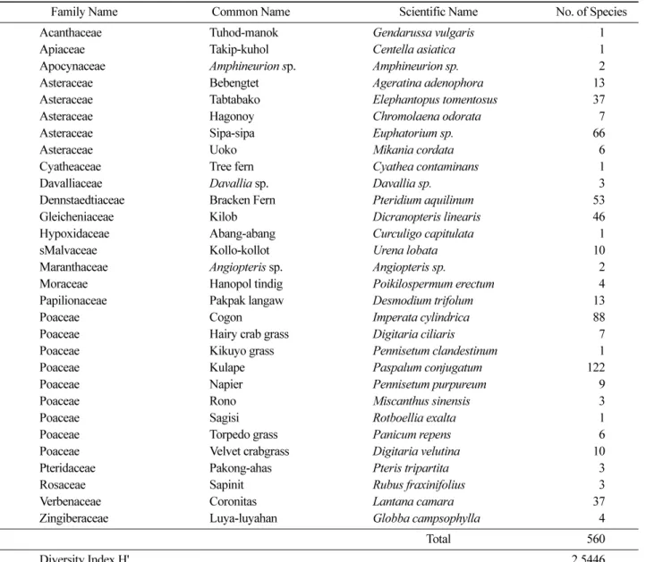
The computed diversity index of species in this forest employing the quadrat method for upper vegetation anal- ysis was 2.6649. On the other hand, there were 30 spe- cies belonging to 18 families found in the established 150 meter transect line or the line intercept method for grasses and low-lying vegetation. A total of 2.5446 diversity index were computed in this vegetation type (Table 2).
Most of the uses of flora species present in this com- munal forest are mainly for timber, lumber, and furniture purposes. Among the families which fall under this pur- pose include Pinaceae, Fabaceae, Lamiaceae and Myrt- aceae. Other uses of some species in the area are for food, condiments, beverages and extractives. Apiaceae, Myrtaceae, Verbenaceae, Poaceae and Rutaceae are among the families suited for these utilizations. Families with medicinal use include Asteraceae, Malvaceae, Fabaceae,
Poaceae and Rosaceae. There are also species from Denn- staedtiaceae, Davalliaceae, Apocynaceae, Maranthaceae, Poaceae and Verbenaceae families suited for ornamental and landscaping purposes.
Pinus kesiya
(Benguet Pine), the most dominant spe- cies is endemic to the region and used as rallying calls for conservation in the community. It is also considered as one of the major species under the DENR reforestation program. Endemicity of species in the area also connotes ecological importance such that they are considered good indication of the status of habitats and ecosystems.
There are about 10 species noted endemic in the country particularly in Luzon area. Of these identified endemic species, three are endemic in Benguet where the study site is located. These are
Glochidium subfalcatum(Nadong)
, Prunus subglabra(Kanumog) and
Ficus benguetensis(Tabul).
Other species with distinct ecological function belongs to families Moraceae, Caprifoliaceae, Cyatheaceae and Euphorbiaceae. An example of species with this function is the
Ficus spp.(tropical figs) under Moraceae family which appeared to be one of the abundant families present in this type of forest.
Ficus spp.can be desig- nated as an umbrella species and keystone species since, according to Terbogh as cited by Catinbog-Sinha and Heaney (2006), this species provides food to a wide variety and numerous fruit-eating birds, wild pigs, native rodents, among others. Aside from this,
Ficus nota(Tibig) and
Cyathea contaminansare usually associated with the abundance of water or moisture in an area (Bacudo
et al.,2006).
The presence of many indicator species in the study areas imply that this communal forest still have a good health condition and diversity status. However, there were three species found in the area that fall under threatened conditions. Two of these species were under the vulnerable category, and these were
Cyathea con- taminans(tree fern) and
Saurauia bontocensis(Deguai).
Another threatened species that was identified in the area was
Prunus subglabra(Kanumog) located in quadrat one of Alapang communal forest (DAO 2007-01, 2007).
2. Faunal assessment
There were four species of birds identified during the study and three of them were endemic in the Philippines.
These were
Nectarinia jugularis jugularis(yellow breasted sunbird),
Sercop calvus calvus(Coleto) and
Lonchura malacca(maya). Other non-endemic bird species found was
Pycnonotus goiavier goviaer(Kulkul). Birds are considered keystone species because they are seed dis- persers and vital to the recruitment of certain plant spe- cies in tropical forest (Catinbog-Sinha and Heaney, 2006).
DI Y
N---- 2
=
Figure 1. Families having the highest number of species in
Alapang communal forest.
Table 1. Overall vegetation analysis, importance value and dominance indices of species present in Alapang communal forest using Quadrat Method.
Family Common Name Scientific Name Relative
Density (RD)
Relative Height
(RH)
Relative Frequency
(RF)
Importance Value
(IV)
Dominance Index Actinidiaceae Deguai
Saurauia bontocensis0.46 1.09 1.47 3.02 0.00010 (DI) Apocynaceae Pandakaking-gubat
Tabernaemontana mucronata0.31 0.15 1.47 1.93 0.00004
Betulaceae Japanese alnus
Alnus japonica0.15 0.07 1.47 1.69 0.00003
Boraginaceae Tanaua
Ehretia acuminata0.31 0.69 1.47 2.46 0.00007
Caprifoliaceae Apit
Viburnum glaberrimum0.62 0.17 1.47 2.25 0.00006
Caprifoliaceae Apit-laparan
Viburnum platyphyllum0.15 0.31 1.47 1.94 0.00004 Caprifoliaceae Taringongog
Viburnum luzonicumvar.
sinuatum0.46 0.78 1.47 2.71 0.00008 Chloranthaceae Baraw-baraw
Chloranthus elatior0.15 0.09 1.47 1.71 0.00003
Chloranthaceae Gipas
Sarcandara glabra4.48 1.08 1.47 7.03 0.00055
Clethraceae Apiit
Clethra luzonica var. novoguineensis2.94 2.48 2.94 8.36 0.00078 Clusiaceae Tunkin
Cratoxylum sumatranumspp.
blancoi0.46 0.32 1.47 2.26 0.00006
Cunoniaceae Kalion
Weinmannia cuneatifolia0.15 0.50 1.47 2.12 0.00005
Ericaceae
Vacciniumsp
Vacciniumsp 0.31 0.32 1.47 2.10 0.00005
Euphorbiaceae Agai
Bridelia tomentosa0.31 0.14 1.47 1.92 0.00004
Euphorbiaceae Balanti
Homalanthus populneus0.93 0.11 1.47 2.51 0.00007
Fabaceae Calliandra
Calliandra calothyrsus6.49 0.76 1.47 8.72 0.00084
Fabaceae Smooth Narra
Pterocarpus indicusforma
indicus0.15 0.07 1.47 1.69 0.00003 Juglandaceae Lupisan-liitan
Engelhardtia serrata0.46 1.34 1.47 3.27 0.00012 Juglandaceae Ped-ped
Engelhardtia spicatavar
. colebrookeana0.93 0.31 1.47 2.71 0.00008
Lamiaceae Agnai
Callicarpa magnifolia3.09 1.33 4.41 8.83 0.00087
Lamiaceae Anuyup
Callicarpa platyphylla0.15 0.09 1.47 1.72 0.00003
Lamiaceae Gmelina
Gmelina arborea0.46 0.07 1.47 2.01 0.00004
Lamiaceae Taringaw-liitan
Callicarpa subintegravar.
parva0.93 0.49 2.94 4.36 0.00021
Lamiaceae Tigaw-sangahan
Callicarpa ramiflora1.39 0.41 1.47 3.28 0.00012
Lauraceae Marang-laparan
Litsea ampla0.15 0.03 1.47 1.66 0.00003
Maesaceae Maesa sp
Maesasp 7.42 2.71 4.41 14.54 0.00235
MelastomataceaeMalatungaw
Melastoma9.74 2.93 4.41 17.07 0.00324
Meliaceae Balubar
Aglaia subviridis0.62 0.25 2.94 3.81 0.00016
Meliaceae Batuakan
Chisocheton pentandrusssp.
paucijugus0.46 0.25 1.47 2.18 0.00005
Meliaceae Mahogany
Swietenia macrophylla1.08 0.30 1.47 2.85 0.00009
Moraceae Hauili
Ficus septica0.77 0.86 1.47 3.10 0.00011
Moraceae Malatibig
Ficus congesta0.46 0.40 2.94 3.80 0.00016
Moraceae Siningsing
Ficus annulata1.08 1.17 1.47 3.72 0.00015
Moraceae Tabul
Ficus benguetensis2.78 0.74 1.47 5.00 0.00028
Moraceae Tibig
Ficus nota0.15 0.16 1.47 1.78 0.00004
Myrsinaceae Pamutul
Ardisia zambalensis0.15 0.06 1.47 1.69 0.00003
Myrsinaceae Panabon
Ardisia serrata0.15 0.06 1.47 1.69 0.00003
Myrtaceae Guava
Psidium guajava9.12 2.86 4.41 16.39 0.00298
Myrtaceae Murray red gum
Eucalyptus camaldulensis0.15 0.31 1.47 1.94 0.00004 Phyllanthaceae Bagnang gubat
Glochidion nitidum0.15 0.08 1.47 1.70 0.00003
Phyllanthaceae Karkarmai
Glochidion ligulatem0.15 0.05 1.47 1.68 0.00003
Phyllanthaceae Karmai-bugkaw
Breynia acuminata0.31 0.19 1.47 1.97 0.00004
Phyllanthaceae Matang-katang
Breynia cernua0.15 0.06 1.47 1.69 0.00003
Phyllanthaceae Nadong
Ghlochidium subfalcatum1.55 0.79 2.94 5.27 0.00031
Pinaceae Benguet Pine
Pinus kesiya33.54 68.79 4.41 106.74 0.12659
Rosaceae Kanumog
Prunus subglabra0.62 1.74 1.47 3.83 0.00016
Rubiaceae Lingong
Lucinaea monocephala0.15 0.31 1.47 1.94 0.00004
Rubiaceae Loher siganog
Praravinia loheri0.31 0.28 1.47 2.06 0.00005
Rubiaceae Rado
Wendlandia warburgii0.46 0.12 1.47 2.05 0.00005
Rutaceae Matang-araw
Melicope triphylla0.31 0.15 1.47 1.93 0.00004
Staphyllaceae Anongo
Turpinia ovalifolia0.15 0.19 1.47 1.81 0.00004
Theaceae Basbasit
Eurya acuminata1.55 0.99 2.94 5.48 0.00033
Total 100.00 100.00 100.00 300.00 0.14190
Aside from birds, a small mammal particularly a rodent was caught during the trapping activity. The
Rattus ever- ettiwas trapped at Alapang communal forest and this species is endemic in the country and widespread in pri- mary forest, uncommon in secondary forest and are absent in agricultural areas. This species seldom destroys crop.
Other species that were observed in the communal for- est were frogs, insects, scorpion, crab, snakes, earthworms and larva of insects. The frog species identified is the
Philautus poecilus
, a Philippine endemic frog and is considered threatened. Forest frogs and other amphibians have been used as indicators of the quality of streams, ponds and marshes. This practice derives from the fact that amphibians depend critically on clean water for egg laying. The presence of frog especially in Alapang forest
denotes that the water in the stream is still clean. Aside from fauna species, the group also encountered species of fungi such as
Calvatia sp.(puff balls),
Pleurotus sp.Table 2. Diversity index of low-lying vegetation in Alapang communal forest using Line Intercept Technique.
Family Name Common Name Scientific Name No. of Species
Acanthaceae Tuhod-manok
Gendarussa vulgaris1
Apiaceae Takip-kuhol
Centella asiatica1
Apocynaceae
Amphineurion sp.
Amphineurion sp.2
Asteraceae Bebengtet
Ageratina adenophora13
Asteraceae Tabtabako
Elephantopus tomentosus37
Asteraceae Hagonoy
Chromolaena odorata7
Asteraceae Sipa-sipa
Euphatorium sp.66
Asteraceae Uoko
Mikania cordata6
Cyatheaceae Tree fern
Cyathea contaminans1
Davalliaceae
Davalliasp.
Davallia sp.3
Dennstaedtiaceae Bracken Fern
Pteridium aquilinum53
Gleicheniaceae Kilob
Dicranopteris linearis46
Hypoxidaceae Abang-abang
Curculigo capitulata1
sMalvaceae Kollo-kollot
Urena lobata10
Maranthaceae
Angiopterissp.
Angiopteris sp.2
Moraceae Hanopol tindig
Poikilospermum erectum4
Papilionaceae Pakpak langaw
Desmodium trifolum13
Poaceae Cogon
Imperata cylindrica88
Poaceae Hairy crab grass
Digitaria ciliaris7
Poaceae Kikuyo grass
Pennisetum clandestinum1
Poaceae Kulape
Paspalum conjugatum122
Poaceae Napier
Pennisetum purpureum9
Poaceae Rono
Miscanthus sinensis3
Poaceae Sagisi
Rotboellia exalta1
Poaceae Torpedo grass
Panicum repens6
Poaceae Velvet crabgrass
Digitaria velutina10
Pteridaceae Pakong-ahas
Pteris tripartita3
Rosaceae Sapinit
Rubus fraxinifolius3
Verbenaceae Coronitas
Lantana camara37
Zingiberaceae Luya-luyahan
Globba campsophylla4
Total 560
Diversity Index H' 2.5446
Figure 2. Tree distribution map on three quadrats established
in Alapang communal forest.
(oyster mushroom),
Trametes sp.(white rot fungus) and
Polyporus sp.(polypore fungus).
3. Spatial mapping and database
Trees found in each quadrant were measured and mapped (Figure 2). Each tree corresponds to one point that have a complete information on its common name, family name, scientific name, height, diameter at breast height, and use/importance. Using the 0.6 meter resolu- tion multi-spectral satellite image of La Trinidad, the boundary of the Alapang communal forest was extracted to come up with a vector map.
An analysis of the sites showing endangered species was performed. Buffer zones showing the hotspots for endangered species were created (Figure 3). The first three 10-meter buffer zones were created to indicate the susceptibility or sensitivity of the area to disturbance. It is therefore a must that these zones or hotspots be pro- tected by the local people and the local government unit to avoid further loss of the biodiversity wealth of the community.
Conclusion
Characterization of different ecosystem is very impor- tant and should not be taken for granted. This study sig- nificantly created information about the current status of the Alapang communal forests. Because of this study, it was discovered that threatened species are living in the area and an immediate action to protect and manage this forest vegetation is necessary. Without conducting a biodi- versity assessment, it is very difficult for the forest man- agers to determine the current situation particularly the species composition of an area.
Pinus kesiya
(Benguet pine), as expected, is still the most dominant species that can be found in most eco- system in this region. Despite of continuous conversion
of forest land into agricultural area, the floral diversity of this particular area is relatively high together with other organisms like fauna and fungi. Different indicator species in the area suggested that this communal forest is still healthy. Therefore, it is recommended to conduct proper delineation of the forest reservation and there should be a visible boundary through establishment of fences in the areas. The DENR and Local Government Unit(LGU) must strictly implement laws on illegal forest activities and biodiversity conservation and initiate and intensify information education and communication cam- paigns together with the academic sector on biodiversity and its importance to community and their adjacent areas.
Acknowledgements
The authors gratefully acknowledge the Jaime V. Ongpin Foundation Inc., for funding this study. Special thanks are also given to the College of Forestry-Benguet State Univer- sity for allowing us to conduct this research. This study was also carried out with the support of ‘Forest Science & Tech- nology Projects (Project No. S211010L010000)’ provided by Korea Forest Service.
Literature Cited
1. Bacudo, A.A., Mores, M.C.L., Palaganas, J.A., Bar- rameda, P.G., Sanchez, K.P. and Salcedo, P.G.. 2006.
Biodiversity Assessment and GIS Mapping of Min- SCAT Forest Reservation. MinSCAT.
2. Buot, I.E, Jr. and Okitsu, S. 1999. Leaf size zonation pattern of woody species along altitudinal gradient on Mt.
3. Pulog, Philippines. Plant Ecology. Kluwer Academic Publishers. Netherlands: 145-208.
4. David, R.S. and Steimer, M.L. Undated. Philippine Orchids, M and L. Licudine Enterprises. 941 Quirino Avenue, Donagle, Parañaque, Metro Manila: 239.
5. Cadiz, R.T. and Mizal, R.B. 1989. Research Informa- tion Series on Ecosystem. Ecosystems Research and Development Bureau-Department of Environment and Natural Resources.
6. Catibog-Sinha, C. and Heaney, L.R. 2006. Philippine Biodiversity Principles and Practices. Conservation.
7. International (Washington D.C.), Nagao Environment Foundation, Haribon Foundation, Kingdom of the Netherlands Foundation for the Philippine Environment and World Wildlife Fund for Nature.
8. Dichoso, W. and Arcilla, R. 1991. Research Informa- tion Series on Ecosystem. Ecosystems Research and Development Bureau-Department of Environment and Natural Resources. Vol. 3 No.10, 1-10.
9. Department of Environment and Natural Resources Figure 3. Buffer zones for threatened species in Alapang
communal forest.
Administrative Order No. 2007-01, 2007.
10. Dupont, J.E. 1971. Philippine Birds. Delaware Museum of Natural History. Greenville, Delaware.
11. Environmental Department-World Bank, 1997. Biodi- versity and Environmental Assessment. Environmental Assessment Sourcebook Update 20: 1-10.
12. Gacoscosim, M.M. 1995. Philippine Forestry in Action.
Phoenix Publishing House, Inc. 927. Quezon Avenue:
49-77.
13. Hallare, A.V. 2001. General Ecology: Concepts of Selected Laboratory Exercises. Busy Book Distributors. Ground Floor UE Sampaloc, Manila: 142-145.
14. Kent, M. and Coker P. 1992. Vegetation Description and Analysis: A Practical Approach. SRP Ltd. Exeter Great Britain: 167-169.
15. Krebs, C.J. 1985. Ecology: The Experimental Analysis of Distribution and Abundance. Third Edition. Harper and Row Publisher, Inc., 10 East 53d St. New York NY 10022: 436-461.
16. Kormondy, E.J. 1965. Concepts of Ecology. Prentice Hall, Inc. Englewood Cliffs New Jersey. 5: 129-135.
17. Madulid, D. 1995. A Pictorial Cyclopedia of Philippine Ornamental Plants. Bookmark Inc., 264 Vito Cruz Extension, Makati Metro Manila.
18. Mueller-Dombois, D. and Ellenberg, H. 1974. Aims and Methods of Vegetation Ecology. John Wiley and Sons Inc., New York: 67-135.
19. Odum, E.P. and Barett, G.W. 2005, Fundamentals of Ecology. Fifth Edition, Brooks, Cole. pp.624.
20. Phillips, O.L., Martinez, R.V., Vargas, P.N., Monteagudo, A.L., Zans, M.C., Sanchez, W.G., Cruz, A.P., Timana, M., Ylihalla, M. and Rose, S. 2003. Efficient Plot-based Floristics Assessment of Tropical forests. J. Trop. Ecol- ogy 19: 629-645.
21. PCCARD-DOST Natural Resource Management Pro- gram-GOP. 1999. The Philippine Recommends for Lumber. 87-89.
22. PCCARD, 1987. Manual on Vegetational Analysis for Grassland and Forest Ecosystems. Department of Sci- ence and Technology, Los Baños, Laguna.
23. PCSD-IEMSDP, 1998. Understanding Philippine Agenda 21. Manila, Philippines, pp.61.
24. Principe, E.B. and Jose, A.S. 2002. Propagation Man- agement of Herbal and Medicinal Plants. Research Information.
25. Series on Ecosystem. Ecosystems Research and Devel- opment Bureau-Department of Environment and Natu- ral Resources.
26. Ticsay, M.T. and Ledesma. 1997 Faunal Inventory of Naujan Lake National Park and its Adjacent Water- shed, Oriental Mindoro, Philippines. SYLVATROP. The Technical Journal for Philippine Ecosystems and Nat- ural Resources. DENR. Vol 8. No. 1: 62-77.
27. Whitemore, T.C. 1984. Tropical Rainforest of the Far East. Second edition. Oxford University Press. Oxford.
(Received October 5, 2010; Accepted October 11, 2010)