JPNT 6(1), 35-41 (2017)
https://doi.org/10.11003/JPNT.2017.6.1.35 JPNT Journal of Positioning,
Navigation, and Timing
1. INTRODUCTION
Precise Point Positioning (PPP) using the Global Navigation Satellite System (GNSS) can determine positioning of users from several millimeters to a few centimeters (cm) if dual- frequency observation data are employed (Zumberge et al.
1997). Since the PPP technique can achieve high accuracy of positioning, it has been widely used in precise orbit determination of low-orbit satellites, precise timing, and GNSS meteorology (Kouba & Heroux 2001, Gao & Shen 2002, Zhang & Andersen 2006, Geng et al. 2010).
In recent years, the European Union (EU) and China have launched their own global satellite navigation systems:
Galileo and BeiDou, so that the use of PPP through multi- system has been increased (Dach et al. 2009, Melgard et al. 2009, Cai & Gao 2013, Chen et al. 2015). The Global
Multi-GNSS Kinematic Precise Point Positioning: Some Results in South Korea
Byung-Kyu Choi
1†, Chang-Hyun Cho
1, Sang Jeong Lee
21
Space Geodesy Group, Korea Astronomy and Space Science Institute, Daejeon 305-348, Korea
2
Department of Electronics Engineering, Chungnam National University, Daejeon 305-764, Korea
ABSTRACT
Precise Point Positioning (PPP) method is based on dual-frequency data of Global Navigation Satellite Systems (GNSS). The recent multi-constellations GNSS (multi-GNSS) enable us to bring great opportunities for enhanced precise positioning, navigation, and timing. In the paper, the multi-GNSS PPP with a combination of four systems (GPS, GLONASS, Galileo, and BeiDou) is analyzed to evaluate the improvement on positioning accuracy and convergence time. GNSS observations obtained from DAEJ reference station in South Korea are processed with both the multi-GNSS PPP and the GPS-only PPP. The performance of multi-GNSS PPP is not dramatically improved when compared to that of GPS only PPP. Its performance could be affected by the orbit errors of BeiDou geostationary satellites. However, multi-GNSS PPP can significantly improve the convergence speed of GPS-only PPP in terms of position accuracy.
Keywords: PPP, multi-GNSS, Positioning accuracy, convergence speed
Positioning System (GPS) has been modernized steadily and Russia has also operated the GLObal NAvigation Satellite System (GLONASS) stably since 2012. Furthermore, the EU has launched the 12th Galileo satellite recently indicating the global satellite navigation system is now entering a final stage of full operation rapidly. BeiDou in China has started positioning, navigation and timing (PNT) services in Asia- Pacific region from the late 2012. In particular, it aims to provide full operational capability by 2020 and has invested heavily in launching satellites and improving performance in navigation systems.
The multi-GNSS PPP, which combines all existing global satellite navigation systems, can improve positioning accuracy and convergence speed due to the use of a large number of observation data compared with using a GPS- only PPP. Li et al. (2015) developed a PPP model using four different navigation systems (GPS + GLONASS + Galileo + BeiDou). They reported the results that multi- GNSS static PPP had improved positioning accuracy by about 25% and convergence speed by about 70% compared with those using GPS-only static PPP. Ren et al. (2015) Received Jan 13, 2017 Revised Feb 07, 2017 Accepted Feb 08, 2017
†
Corresponding Author E-mail: [email protected]
Tel: +82-42-865-3237 Fax: +82-42-861-5610
36 JPNT 6(1), 35-41 (2017)
presented that PPP performance had improved in multi- GNSS PPP compared with GPS-only PPP. In particular, mean positioning accuracy in the horizontal and vertical directions had improved by 20% and 30%, respectively.
Seepersad & Bisnath (2014) reported that GPS static PPP took around 20 minutes (min) to reach 20 cm or less horizontal positioning accuracy within 95% confidence level and GPS kinematic PPP took longer convergence speed than GPS static PPP. Particularly, they presented that at least 60 min convergence speed was required to obtain a 5 cm or less horizontal positioning accuracy statistically.
In order to determine user position accurately through the PPP method, precise orbit and clock products of navigation satellite must be available. Similarly, it is also necessary to have precise information about not only existing GPS and GLONASS orbit and clock products but also precise products about Galileo and BeiDou in order to perform multi-GNSS PPP. International GNSS Service (IGS) has provided precise orbit and clock products of multi- GNSS through the Multi-GNSS Experiment campaign. In particular, IGS Analysis Centers at GeoForschungs Zentrum in Germany, Wuhan University in China, and Center for Orbit Determination in Europe in Switzerland provide orbit and satellite clock products of Galileo and BeiDou satellites, so that data of Multi-GNSS PPP can be processed.
The present study introduces a strategy required for multi-GNSS PPP and analyzes positioning accuracy and convergence speed of multi-GNSS PPP using measurements of different navigation systems received at the GNSS reference station in the Korea Astronomy and Space Science Institute. In addition, the results of multi-GNSS PPP are compared to those of GPS PPP.
2. MULTI-GNSS PPP PROCESSING STRATEGY
In order to perform PPP using measurements of different navigations systems received at GNSS receivers, it is necessary to select dual-frequency for each navigation satellite system. The present study employs L1 (1575.42 MHz) and L2 (1227.60 MHz) of the GPS and frequencies calculated through Eqs. (1) and (2) using frequency division multiple access.
L1 = (1602 + k × 0.5625) MHz (1) L2 = (1246 + k × 0.4375) MHz (2)
Here, k (k = 0,1,2,...) refers to a frequency channel number.
The Galileo signal employs E1 (1575.42 MHz) and E5a
(1176.45 MHz), and the BeiDou signal employs B1 (1561.098 MHz) and B2 (1207.14 MHz). The reason for using dual- frequency data in PPP data processing is to remove an ionospheric error, which is regarded as the largest error when the navigation signals of GNSS transmit from a satellite to a receiver (Kouba & Heroux 2001, Geng et al. 2010). The measurement equation for removing the ionospheric error is presented in Eq. (3) (Odijk 2003).
different navigation systems (GPS + GLONASS + Galileo + BeiDou). They reported the results that multi-GNSS static PPP had improved positioning accuracy by about 25% and convergence speed by about 70% compared with those using GPS-only static PPP. Ren et al. (2015) presented that PPP performance had improved in multi-GNSS PPP compared with GPS-only PPP. In particular, mean positioning accuracy in the horizontal and vertical directions had improved by 20% and 30%, respectively. Seepersad & Bisnath (2014) reported that GPS static PPP took around 20 minutes (min) to reach 20 cm or less horizontal positioning accuracy within 95% confidence level and GPS kinematic PPP took longer convergence speed than GPS static PPP. Particularly, they presented that at least 60 min convergence speed was required to obtain a 5 cm or less horizontal positioning accuracy statistically.
In order to determine user position accurately through the PPP method, precise orbit and clock products of navigation satellite must be available. Similarly, it is also necessary to have precise information about not only existing GPS and GLONASS orbit and clock products but also precise products about Galileo and BeiDou in order to perform multi-GNSS PPP. International GNSS Service (IGS) has provided precise orbit and clock products of multi-GNSS through the Multi-GNSS Experiment campaign. In particular, IGS Analysis Centers at GeoForschungs Zentrum in Germany, Wuhan University in China, and Center for Orbit Determination in Europe in Switzerland provide orbit and satellite clock products of Galileo and BeiDou satellites, so that data of Multi-GNSS PPP can be processed.
The present study introduces a strategy required for multi-GNSS PPP and analyzes positioning accuracy and convergence speed of multi-GNSS PPP using measurements of different navigation systems received at the GNSS reference station in the Korea Astronomy and Space Science Institute.
In addition, the results of multi-GNSS PPP are compared to those of GPS PPP.
2. MULTI-GNSS PPP PROCESSING STRATEGY
In order to perform PPP using measurements of different navigations systems received at GNSS receivers, it is necessary to select dual-frequency for each navigation satellite system. The present study employs L1 (1575.42 MHz) and L2 (1227.60 MHz) of the GPS and frequencies calculated through Eqs. (1) and (2) using frequency division multiple access.
L1 = (1602 + k × 0.5625) MHz (1) L2 = (1246 + k × 0.4375) MHz (2)
Here, k (k = 0,1,2,...) refers to a frequency channel number.
The Galileo signal employs E1 (1575.42 MHz) and E5a (1176.45 MHz), and the BeiDou signal employs B1 (1561.098 MHz) and B2 (1207.14 MHz). The reason for using dual-frequency data in PPP data processing is to remove an ionospheric error, which is regarded as the largest error when the navigation signals of GNSS transmit from a satellite to a receiver (Kouba & Heroux 2001, Geng et al.
2010 ). The measurement equation for removing the ionospheric error is presented in Eq. (3) (Odijk 2003).
𝐿𝐿
𝐼𝐼𝐼𝐼=
𝑓𝑓𝑓𝑓1212−𝑓𝑓22
𝐿𝐿1 −
𝑓𝑓𝑓𝑓2212−𝑓𝑓22
𝐿𝐿2 (3) (3)
Here, L
IFrefers to observables derived by the ionosphere- free linear combination, and f
1and f
2refer to different frequencies of navigation systems.
A variety of models and methods should be considered to obtain precise positioning solution through PPP data processing. For the tropospheric dry delay, which is one of the important estimate variables, the Saastamoinen model (Saastamoinen 1973) and global mapping function (GMF) developed by Boehm et al. (2006) were applied. For the meteorological information (temperature and pressure) required as input values of the Saastamoinen model, global pressure and temperature 2 (GPT2) model developed by Lagler et al. (2013) was employed. Furthermore, a tropospheric gradient component (G
N, G
E) in the horizontal direction was designed to be estimated to improve accuracy of wet delay. For a phase center offset (PCO) of satellite antenna for each navigation system, a PCO of receiver, and a phase center variation (PCV), information provided by igs08.atx was used and bi-linear interpolation technique was used to interpolate a PCV. Additionally, models and methods applied for PPP are presented in Table 1 in detail.
The variable vector calculated through multi-GNSS PPP data processing can be expressed as shown in Eq. (4).
X = (x, y, z, dtr, ZWD, G
N, G
E, ISB
R, ISB
E, ISB
C,N) (4)
Here, x, y, and z refer to a receiver position; dtr refers to a clock error of the receiver; Zenith Wet Delay (ZWD) is a tropospheric wet delay value; ISB
R, ISB
E, and SB
Crefer to the inter-system biases of GLONASS, Galileo, and BeiDou on the basis of the GPS system. N refers to phase ambiguity parameter.
3. RESULTS AND ANALYSIS
In order to analyze positioning accuracy at the receiver
estimated by the multi-GNSS PPP, data obtained from
Daejeon (DAEJ) GNSS reference station in the Korea
Byung-Kyu Choi et al. Multi-GNSS Kinematic PPP 37
Astronomy and Space Science Institute were processed.
Furthermore, the results were compared with that of GPS- only PPP to compare a convergence speed of the initial position. The processing period of the GNSS observation data was 31 days from May 1 to 31, 2016 and data processing was done every 30 sec.
First, satellite data received at the DAEJ GNSS reference station on May 1, 2016 were analyzed to determine visibility about navigation satellites over the Korean Peninsula. Fig. 1 shows the change in the number of GNSS navigation satellites received for a day. At least 20 up to 30 navigation satellites were observed at the DAEJ GNSS reference station.
Except for Galileo satellite in the EU, at least four satellites were observed regardless of temporal change in all of GPS, GLONASS, and BeiDou. It is remarkable that more BeiDou satellites were observed on average than GLONASS satellites over the Korean Peninsula in recent years.
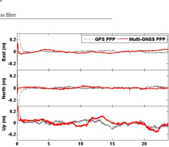
Fig. 2 shows a time series of positioning error at the reference station estimated via multi-GNSS PPP and GPS- only PPP, using data received for a day from DAEJ reference station on May 1, 2016, respectively. In the figure, GPS PPP and multi-GNSS PPP are marked with gray dotted line and red solid line, respectively. The IGS analysis data was used for an accurate coordinate in the DAEJ reference station in order to ensure reliability of positioning error.
Fig. 2 can be analyzed from two different points of view.
First, positioning accuracy can be compared according to different data processing methods. Although multi-GNSS PPP that combined data of GPS+GLONASS+Galileo+BeiDou navigation satellites was expected to have better positioning accuracy than that of GPS PPP, a root mean square (RMS) value increased from 1.05 cm to 1.81 cm and from 3.81 cm to 4.93 cm in the east and up directions, respectively, indicating positioning accuracy degradation instead. That Fig. 1. Diurnal variations of the number of GNSS satellites tracked at ‘DAEJ’
reference station in South Korea on May 1, 2016.
Fig. 2. Comparison of position errors between GPS kinematic PPP and multi-GNSS kinematic PPP. The position errors estimated by the multi- GNSS kinematic PPP are shown by red line, while those of GPS kinematic PPP are represented by gray dashed line.
Table 1. Multi-GNSS PPP processing strategy.
Item Models / Methods