소방분야의 드론 활용방안 연구 경향 분석
하강훈
1, 김재호
2, 최재욱
3*1순천제일대학교 소방방재과, 2순천제일대학교 산업안전관리과, 3부경대학교 소방공학과
A study on the application of drone in firefight field
Kang Hun Ha
1, Jae Ho Kim
2, Jae Wook Choi
3*1Dept. of Fire Disaster Prevention, Suncheon Jeil College,
2Dept. of Fire Industrial Safety Management, Suncheon Jeil College,
3Dept. of Fire Protection Engineering, Pukyoung National University.
요 약 본 연구는 국내·외 논문들을 검토하여 드론이 활용되고 있는 다양한 분야를 조사하고, 이를 바탕으로 소방공무원
의 업무에 드론이 활용될 수 있는 분야를 제시하였다. 연구결과를 종합해보면 드론의 활용분야는 수색(51%), 재난 및
화재 모니터링(35%), 운송(14%) 순으로 가장 많이 이용되는 것으로 나타났다. 이를 보다 구체적으로 살펴보면 다음과
같다. 첫째, 수색 연구 분야에서는 드론의 융합시스템 개발과 활용으로 기존방식인 인력을 통한 수색업무에 비해 드론을
활용하는 것이 인력과 장비, 시간, 비용 등의 측면에서 효율적인 것으로 나타났다. 둘째, 재난 및 화재 모니터링분야에서
는 드론을 통해 재난 및 화재 현장을 실시간으로 분석함으로써 소방공무원의 안정성 확보와 재난현장파악에 도움이 되는
것으로 확인되었다. 셋째, 운송 분야의 연구에서는 구조물품과 구호용품, 비상의약품 등을 빠른 시간에 운반하여 응급
상황에서의 골든타임을 확보할 수 있는 것으로 나타났다. 본 연구는 소방분야의 드론 활용방안에 대한 기초자료와 활용
분야를 제시함으로써 급격히 변화하는 재난 환경과 고령화되고 있는 소방공무원의 환경 속에서 소방조직의 드론 활용에
대한 방향성을 제시하였다는데 그 의미가 있다.
Abstract By reviewing domestic and international papers, this study examines various fields in which
drones are used, and based on the results, fields are suggested in which drones can be used for the work
of firefighters. Overall, the research results show that drones are most commonly used for search (51%),
disaster and fire monitoring (35%), and delivery (14%). Specifically, in the search field, using a drone is
more efficient in terms of manpower, equipment, time, and cost than using people, which is the current
practice. Secondly, in disaster and fire monitoring, drones can analyze and identify disasters and fire
sites in real time. Therefore, it was confirmed that the use of drones is helpful in securing the safety
of firefighters and identifying a disaster site. Third, research in logistics shows that drones can secure
the so-called golden time in emergency situations by delivering rescue and relief supplies, emergency
medicine, and blood in short order. In a rapidly changing disaster environment, and considering aging
in firefighters, this study is meaningful in that it promotes drone utilization in the firefighting field by
investigating basic data on drone utilization plans.
Keywords : Drone Utilization, Fire Fight, Search, Monitoring, Delivery
*Corresponding Author : Jae Wook Choi(Pukyoung National Univ.) email: jwchoi@pknu.ac.kr
Received December 4, 2020 Revised January 5, 2021 Accepted April 2, 2021 Published April 30, 2021
1. 서론
크고 작은 사회재난과 자연재난 등의 업무에 대응하고
대처하는 중심에는 소방공무원이 있다. 최일선에서 국민
의 생명과 재산을 보호하는 소방공무원의 필요성과 중요
성은 시대가 지남에 따라 날로 증가하고 있다. 특히, 현장
최일선에서 활동하는 대표직종인 소방공무원은 예측할
수 없는 각종 사건/사고 및 구조 현장 속에서 많은 사상
자를 구조하고 있다. 하지만 소방공무원 자신 역시 이러
한 위험이나 유해한 환경 속에 지속적으로 노출되고 있다.
소방공무원은 업무 특성상 강한 체력과 정신력이 요구
되는 특성을 가지고 있지만, 최근 소방공무원의 고령화가
급격히 진행되고 있다.
조성완의 연구에 따르면 2015년 전체 소방공무원
94,617명중 20대와 30대가 11,971명으로 전체 4%, 50
대 이상의 소방공무원은 40,609명으로 전체 43%로 나
타나 소방 공무원의 고령화 현상도 심각한 것으로 나타
났다[1]. 이러한 고령화 현상은 강한 체력을 요구하는 소
방공무원의 업무 능력 저하에 직접적인 영향을 준다. 따
라서 이를 대처하거나 보조할 수 있는 장비에 대한 개발
이나 적용이 절실히 필요한 시점이다. 이러한 관점에서
현재 다양한 분야에서 활발하게 사용되고 있는 드론이
소방업무에 활용될 것으로 예상된다. 드론은 시공간의 제
약이 없고 여러 센서 및 시스템 등을 탑재하여 다양한 소
방업무를 지원할 수 있는 가장 적합한 첨단장비이기 때
문이다[2].
재난, 치안, 환경 등의 분야에 드론을 도입하기 위해
각 부처별로 ‘2018년도 국민안전 감시 및 대응 무인항공
기 융합시스템구축 및 운용 사업추진위원회’를 개최하여
부처 별 임무에 적합한 드론 개발계획을 발표하였다. 특
히 소방청은 약 43.2억 원을 투입하여 소방의 재난대응
임무에 특화된 임무장비 및 소프트웨어를 개발하고 있다
[3]. 일부 소방서 및 지역 센터에서 꾸준히 소방 업무에
드론을 활용하려는 시도가 있지만 체계를 갖추지 못하거
나 운영 중단된 사례가 발생하고 있으며, 드론활용 분야
에 대한 연구도 미흡한 실정이다[4].
정보통신기술과 빅 데이터 분석 등의 기술을 드론과
융합하여 소방 업무에 활용할 수 있는 가이드라인이 마
련되어 있지 않고, 관련된 연구 또한 찾아보기 힘들다. 따
라서 드론을 소방 업무에 적용하기 위한 체계적인 활용
분야를 구축하는 것이 매우 중요하다고 판단된다. 따라서
본 연구는 국내외 문헌조사를 바탕으로 드론 적용 및 활
용의 목적을 분류하고 소방분야에 활용할 수 있는 분야
를 제시하고자 하는 것이 본 연구의 목적이다.
2. 연구 방법
본 연구는 기존의 연구를 통해 드론이 활용되고 있는
분야를 조사하고 소방공무원의 업무에 활용될 수 있는
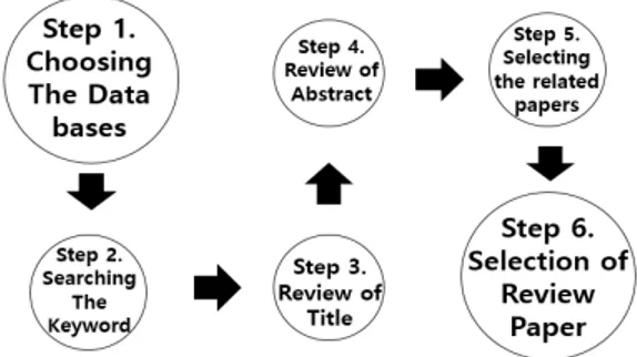
드론의 활용분야를 제시하기 위해 Fig. 1.의 방식으로 기
존의 문헌을 조사하였다. 문헌조사는 다양한 기능을 제공
하고 있는 Google Scholar, DBpia, RISS, KISS 등의
Database Serch Engine을 선정하고 2010~2020년 현
재까지 등재된 국내 및 국외 논문을 대상으로 키워드를
검색하였다. 검색 영문 키워드는 ”fire fighter“, ”drone“,
”first aid“, ”fire suppression“, ”safety“, ”disaster“
등이었으며, 국문 키워드는 ”소방“, ”드론“, ”화재진압“, ”
수색“, ”구조“, ”구급“, ”재난“ 등을 활용하였다. 키워드로
검색된 자료는 제목 검토를 통하여 본 연구와 관련성이
높은 자료를 1차적으로 선정하였고, 이를 대상으로 초록
검토를 실시하였다. 검토를 실시하는 이유는 방대한 자료
와 관련성이 적은 자료가 포함되어 있기 때문이다. 이후
초록 검토를 통해 소방분야의 드론 활용방안을 제안할
수 있는 연구를 선정하였다. 키워드 검색을 통해 최초 선
정된 논문은 500여편이었으나, 제목, 초록 검토 등의 순
으로 논문을 선별 후 본 연구와 관련성 높은 논문 51편
을 선정하여 최종 분석하였다.
Fig. 1. Methodology of literature review
3. 연구 결과
드론을 이용한 연구 분야는 다양한 분야에서 이뤄지고
있다. 본 연구에서는 기존의 문헌을 통해 소방 분야에 적
용할 수 있는 드론의 연구 동향을 분석하였으며, 소방 드
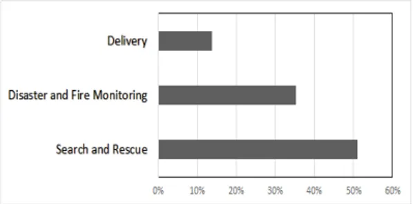
론의 활용 목적에 따른 연구 분야를 분석한 결과 Fig. 2.
와 같이 수색에 대한 연구는 약 51%, 재난 및 화재 모니
터링에 대한 연구는 약 35%, 운반(기자재 등) 분야의 연
구는 약 14% 순으로 수색 분야의 연구가 활발히 진행되
고 있다는 것을 알 수 있다.
Fig. 2. Classification by purpose of use of firefighting drones
3.1 수색 연구
드론을 활용한 연구 분야는 위와 같이 수색 분야에 관
한 연구가 가장 활발히 이루어지고 있다. 특히 드론은
시·공간에 구애 받지 않고 넓은 시야를 이용해 다양한 장
소를 수색할 수 있으며, 드론을 활용해 수색할 경우 기존
의 인력 중심의 수색에 필요한 인력, 장비, 등의 비용에
비해 약 10% 수준인 것으로 나타났다[3].
국내 연구로는 김진 등은 드론 분할비행관리 시스템을
이용하여 각각의 드론이 누락되는 영역 없이 일정한 간
격을 유지하며 조난자를 탐색할 수 있는 방법에 대하여
제언하였고[5], 차정훈 등은 드론을 활용한 실제 수색 사
례를 바탕으로 접근이 힘든 해안, 하천, 고층 건물 등과
재난 현장에서 드론으로 획득한 영상 및 사진 데이터를
이용해 Deep Learning 패턴인식을 알고리즘에 적용한
효과적인 드론 수색방법을 제안하였다[6]. 이우식 등은
드론을 활용하여 매몰자의 휴대기기에서 송출되는 무선
신호를 감지하여 위치를 감지하고, 주변 지형을 3D 모델
링 하여 매몰자의 위치를 시각화하는 시스템을 구현하였
고[7], 김동현 등은 선박사고 시 해상 인명사고에 대비하
기 위해 장거리, 광대역 멀티미디어 통신을 지원하는 드
론을 설계하였고 실험을 통해 드론을 통한 멀티미디어
데이터 전송, 영상처리화면을 통한 사물 식별 등을 검증
하였다[8].
국외 연구로는 Valsan 등은 건물 잔해에서 드론이 수
색 임무 수행 중 매몰자를 발견하면 수동 적외선 센서의
High 신호와 GPS(Global Positioning System) 모듈
을 사용하는 위치 좌표가 마이크로 컨트롤러를 통해 구
조대에 정보를 발신하는 드론 시스템을 제안하였고[9],
Krishna 등은 Pixhawk Flight Controller, SiK
telemetry air module, 2.4 GHz radio receiver 등의
시스템을 탑재한 드론을 설계하였다. 설계한 드론은 움직
이는 사람을 추적, 감지하고 Matlab Ide(Integrated
Development Environment)의 동작 감지 알고리즘에
전송되고 전송된 알고리즘을 수신한 구급대는 구조 지역
에서의 우선순위를 결정함으로써, 효과적인 수색 작업을
진행 할 수 있는 프로그램을 제안하였다[10].
Rohman 등은 UWB(Ultra Wide Band) radar,
microphone array, vision camera, RFID(radio
frequency Identification) sensors 등의 여러 센서가
탑재된 감시 드론은 조종자의 근거리에 배치되어 재난
피해 지역을 조사하고 탐지 된 생존자의 위치와 좌표가
실시간으로 메인 서버로 전송되어 4G-WAN 네트워크를
통해 구조 팀이 원격으로 모니터링 할 수 있는 드론을 제
안하였다[11].
Silvagni 등은 눈사태가 발생하였을 경우 정확한 매립
자 수색에 적합한 드론을 제안하기 위한 실험을 진행하
였다. 실험은 눈사태가 발생한 상황을 가정하여 진행하였
으며, 눈사태 비콘이 눈사태 신호를 발신하면 드론은 식
별지점까지 GRID비행하고 식별된 지점에 도착하면 정
밀한 매립자 수색을 위해 CROSS비행 후 해당 비콘으로
착륙하여 구조대에 위치를 전송하거나 수색 업무를 진행
할 수 있는 드론을 제안하였다[12].
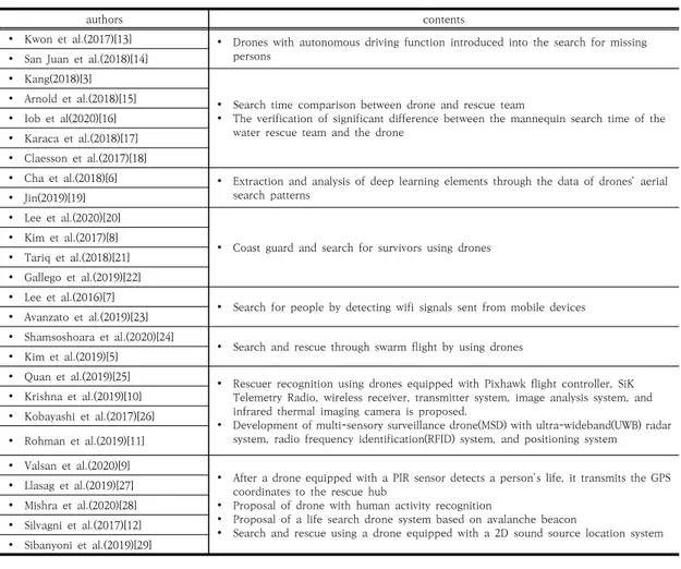
소방조직의 구조·구급 등의 업무에 활용될 수 있는 수
색 분야의 대표적인 연구는 Table 1.과 같이 정리 할 수
있다.
3.2 재난 및 화재 모니터링에 대한 연구
드론은 지리적 특성 및 재해 현장과 장애물에 구애 받
지 않고 이동할 수 있는 특징이 있어 소방대원의 출동 및
화재진압, 구조, 구급 활동 등에 다양한 정보를 수집할 수
있다[30]. 이러한 드론의 장점을 이용해 드론을 이용한
재난 및 화재 모니터링에 대한 연구도 활발히 진행되고
있다.
국내 연구로는 김성삼 등은 호우, 태풍피해 등의 현장
을 대상으로 드론과 드론맵핑 기술을 활용하여 3차원 재
난현장 지형정보와 정사영상 지도를 생성하는 연구를 진
행하였다. 연구 결과 산사태 피해 면적, 유실 거리, 하천
시설물의 파손, 토사 유출 흔적 등의 현장 피해정보를 확
인할 수 있었고 3차원 점군 자료를 활용하여 산사태로
인해 유출된 쇄굴 폭과 깊이, 토사 유출 거리를 측정, 피
해 면적을 보다 정확하게 산정할 수 있었다[31].
authors contents
Kwon et al.(2017)[13] Drones with autonomous driving function introduced into the search for missing persons
San Juan et al.(2018)[14]
Kang(2018)[3]
Search time comparison between drone and rescue team
The verification of significant difference between the mannequin search time of the water rescue team and the drone
Arnold et al.(2018)[15]
Iob et al(2020)[16]
Karaca et al.(2018)[17]
Claesson et al.(2017)[18]
Cha et al.(2018)[6] Extraction and analysis of deep learning elements through the data of drones' aerial search patterns
Jin(2019)[19]
Lee et al.(2020)[20]
Coast guard and search for survivors using drones
Kim et al.(2017)[8]
Tariq et al.(2018)[21]
Gallego et al.(2019)[22]
Lee et al.(2016)[7]
Search for people by detecting wifi signals sent from mobile devices
Avanzato et al.(2019)[23]
Shamsoshoara et al.(2020)[24]
Search and rescue through swarm flight by using drones
Kim et al.(2019)[5]
Quan et al.(2019)[25] Rescuer recognition using drones equipped with Pixhawk flight controller, SiK Telemetry Radio, wireless receiver, transmitter system, image analysis system, and infrared thermal imaging camera is proposed.
Development of multi-sensory surveillance drone(MSD) with ultra-wideband(UWB) radar system, radio frequency identification(RFID) system, and positioning system
Krishna et al.(2019)[10]
Kobayashi et al.(2017)[26]
Rohman et al.(2019)[11]
Valsan et al.(2020)[9]
After a drone equipped with a PIR sensor detects a person's life, it transmits the GPS coordinates to the rescue hub
Proposal of drone with human activity recognition
Proposal of a life search drone system based on avalanche beacon
Search and rescue using a drone equipped with a 2D sound source location system
Llasag et al.(2019)[27]
Mishra et al.(2020)[28]
Silvagni et al.(2017)[12]
Sibanyoni et al.(2019)[29]
Table 1. Studies of Search and Rescue
이종훈 등은 드론매핑 지도와 커뮤니티매핑 정보를 연
계해 관리자에게 재난 현장의 다양하고 상세한 정보를
제공하는 드론을 구현하였다. 이를 통해 피해지역의 복구
우선순위 결정, 피해규모 파악 및 복구비용 산정 등을 관
리자가 재난 복구단계에서 효율적으로 판단할 수 있을
것이라 제언하였다[32].
박남희 등은 여러 개의 입출력 주변장치를 지원할 수
있는 Raspberry Pi, LTE 통신, 드론의 카메라로부터 촬
영된 영상정보를 전송받아 방송할 수 있는 Ground
Control Station을 드론에 추가적으로 장착하여 원격
및 자동조정을 통해 원격으로 재난방송을 전송함으로써,
재난에 대응할 수 있는 시스템을 제안하였다[33]. 이정훈
등은 드론을 활용하여 산지재해 발생 시 인근 도로의 안
전성을 위협할 수 있는 구간을 분석하고 분석한 자료를
산사태 위험 분석 프로그램인 SINMAP(Stability Index
Mapping)모형에 적용하는 방안을 제시하였다. 또한 분
석된 프로그램을 이용하여 최신 지형정보를 반영하기 어
려운 재해 발생 위험지역에 신속한 지형정보를 제공하여
관리, 보강, 안전대책수립 등의 의사결정 자료로 사용할
수 있을 것으로 제언하였다[34].
국외 연구로는 Simoes 등은 소방관의 데이터를 수집
할 수 있는 Flying Ad-hoc Network 및 카메라, 초음파
및 온도센서가 있는 드론을 활용하여 산불 발생 시 산불
지역을 모니터링하고 드론이 소방관을 추적하여 화재 현
장에 대응할 수 있는 드론 프로그램을 제안하였다[35].
Aljehani 등은 재난지역 피해민의 휴대폰을 추적할 수
있는 드론 추적 시스템을 이용하여 재해 발생 지역에 재
난지역 주민들이 안전하게 이동할 수 있는 재난안전 맵
을 제안하였다[36].
Pham 등은 분산 제어 드론 시스템을 통하여 산불 발
생 시 드론이 산불을 따라 이동하며 산불이 확산할 가능
성이 높은 이동경로를 예측하여 정보를 제공하는 프로그
authors contents
Kim et al.(2019)[31]
Analysis of damage scale after generating 3D disaster topographic information and orthogonal image map using drone-mapping technology
Proposal for a system that can grasp support such as prioritization of restoration in disaster-affected areas and the scale of damage
Proposal for a drone architecture system that transmits disaster situations on a 3D screen.
Proposal of a program to evaluate fire severity through images transmitted from drones
3D reconstruction of collapsed buildings using images taken with drones
Verykokou et al.(2018)[39]
Kim et al.(2019)[40]
Lee et al.(2019)[32]
Lee et al.(2016)[41]
Nam et al.(2019)[42]
Park et al.(2019)[33]
Deng et al.(2019)[43]
Cho(2018)[2] Finding a plan that can be used ing the field of disaster through drone journalism
Lee et al.(2018)[34] Analyze sections that may threaten the safety of nearby roads in the event of a mountainous disaster
propose modelling of earthquake sites through multiple drones
Zhang et al.(2019)[38]
Simoes et al.(2020)[35] Provide effective data to firefighters by tracking and monitoring firefighters using drones
Proposal for a system that monitors the fire front to track and transmit the moving route prediction situation
Pham et al.(2020)[37]
Islam et al.(2019)[44]
Rabinovich et al.(2018)[45]
Aljehani et al.(2019)[36] Safe map creation for disaster victims through mobile GPS, tracking pedestrians and area scanning
Al-Naji et al.(2019)[46] Life Signs Detector Using a Drone in Disaster Zones
Mihnea et al.(2020)[47] Transmission of post-explosive environmental conditions data using drones equipped with control system and image identification unit
Table 2. Studies of disaster and fire monitoring
램을 제안하였고[37], Zhang 등은 다중 드론을 통한 지
진 현장의 모델링을 제안하였다. 지진 발생 후 2차 지진
의 발생 가능성이 높은 점을 감안하여 진도 7.0의
Jiuzhai Valley의 실제 지진 데이터를 이용한 시뮬레이
션을 진행하였으며, 시뮬레이션을 통해 다중 드론의 통합
재난 조사 및 검색 방법을 제안하였다[38].
드론을 이용한 재난 및 화재 모니터링에 대한 연구는
Table 2.와 같이 정리할 수 있다.
3.3 운송 분야의 연구
전 세계적으로 선도적인 기업들은 경쟁적으로 드론을
이용한 운반에 대하여 연구하고 있다. 아마존은 2013년
16km 이내 지역에서 30분 이내 자동 배송을 할 수 있는
아마존 프라임 에어를 발표하였고, DHL은 2014년 파슬
콥터(Parcelcopter)를 이용해 의약품 배송에 성공하였
다. 이처럼 드론은 다양한 기자재 등의 운반 능력을 인정
받아 여러 분야의 운반 작업에 사용되고 있다[48].
하지만 소방 분야에서의 드론을 이용한 운반은 구명부
표, AED(Automated External Defibrillator) 전달, 혈
액 운송 등의 극히 일부분으로 한정되어 진행되고 있다.
Sanfridsson 등은 병원 밖에서 심정지 환자 발생 시 드
론을 이용해 심정지 환자(마네킹) 주변으로 AED를 제공
하고 심정지 환자 주변에 있는 일반인이 드론의 안내 방
송에 따라 AED를 사용하는지 알아보기 위한 실험을 진
행하였다. 마네킹 주변의 일반인은 노인 단체에서 모집되
었으며, 20년간 심폐소생술이나 의료교육을 받지 않은
그룹으로 구성되었다. 실험 결과 드론을 이용하여 AED
를 배송하는 것이 심정지 환자의 골든타임을 확보하는데
큰 역할을 하였으며 실험에 참가한 마네킹 주변의 일반
인 역시 드론의 안내방송에 따라 행동하였다[49].
Sanjana 등은 구급차가 응급 출동을 하는 상황에서
교통 체증 등의 불가피한 경우로 정체되면 Gyroscope
센서, 가속도센서, GPS 센서가 탑재된 드론이 앱을 통해
신고자의 위치를 파악하여 응급처치키트를 운반할 수 있
는 방안을 제안하였다[50].
Seguin 등은 부양 장치를 전달하는 드론이 다양한 해
양 상황에서 구조대원보다 효율적으로 익수자에게 부양
장치를 전달할 수 있는지 여부를 실험을 통해 평가하였
다. 실험은 익수자 역할을 하는 전문 구조대원이 해양사
고를 당한 것으로 가정하였고, 실험 환경은 파도와 바람
의 조건에 따라 28번 테스트 하였으며, 익수자를 발견하
였을 경우 가장 가까운 곳의 구조대원, 제트스키를 이용
authors contents
Seguin et al.(2018)[51] Propose a method of delivering the life jacket of a drone by analyzing the average time that rescue workers and drones deliver the life jacket
Bäckman et al.(2018)[54]
Sanfridsson et al.(2019)[49] Delivery of AED to drone when cardiac arrest occurs
Nair et al.(2019)[52] Transport inflating vest of drones through location tracking of wrist band equipped with emergency button
Sanjana et al.(2020)[50] Information on drone medicine delivery, hospital information, and first aid methods through the app
Kim et al.(2017)[55] Propose a search and rescue method using drones which make it possible to save a man overboard within 30 minutes of an incident.
Amukele et al.(2017)[53] Blood delivery using drones Table 3. Studies of Delivery(rescue kit, AED, blood etc.)
한 구조대원, 부양 장치가 탑재된 드론이 부양 장치를 익
수자에게 전달하는데 소요 된 시간을 비교하였다. 실험
결과, 드론은 파도 등의 조건에 구애 받지 않았으며, 구조
대원보다 익수자에게 부표를 전달하는 시간보다 빠른 것
으로 나타났다[51].
Nair 등은 비상버튼이 장착된 손목밴드를 이용하여
위급상황 시 손목밴드의 비상버튼을 누르면 드론이 비상
버튼 위치로 이동하여 구명조끼를 전달하는 드론을 제안
하였다. 손목밴드는 GPS와 ZigBee Transmitter의 기
능을 탑재하였고, 비상상황에서 버튼을 누르면 ZigBee
Recevier의 기능이 탑재된 드론이 수신하여 가장 가까
운 드론이 GPS좌표의 익수자에게 이동하여 구명조끼를
떨어뜨리는 방식으로 실험이 진행되었다. 실험 결과 드론
은 60초 이내에 익수자에게 구명조끼를 전달할 수 있는
것으로 나타났다[52].
Amukele 등은 드론으로 혈액 운송 시 혈액의 안정성
을 평가하고 비행 중 혈액의 온도를 유지할 수 있는지 여
부에 대한 실험을 진행하였다. 실험에 필요한 PLT(Platelets)
및 RBC(Red Blood Cell) 는 멸균 연결 장치를 사용하
여 보관하였고 Plasma Units(FP24)는 4.7L Cooler로
옮겨 드론에 부착한 후 지상 100m 위의 고도에서 약 22
분 이동하여 그 결과를 살펴보았다. 실험 결과 주변온도
와 드라이아이스의 영향으로 온도가 약 1.5~4°C 미세하
게 감소하였지만 드론이 혈액 운반에도 이용될 수 있다
는 것을 증명하였다[53].
소방 분야에 활용할 수 있는 드론의 운반분야에 대한
연구는 Table 3.과 같다.
4. 결론
본 연구는 국내·외 약 500여 편의 드론 연구 중 소방
업무에 활용 가능성이 높은 51편의 연구를 심층 분석하
여 국내 소방 분야에 적용할 수 있는 드론의 여러 활용
분야를 제시함으로써, 아직 시작 단계인 소방 드론의 다
양한 활용 분야를 제안하였다.
선별된 51편의 연구를 분석한 결과, 수색 분야(51%)
의 연구가 가장 높은 비중을 차지하였으며, 다음으로 재
난 및 화재 모니터링에 대한 연구(35%), 운반(기자재 등)
분야(14%)의 순으로 나타났으며, 분석한 연구 분야는 다
음과 같이 정리 할 수 있다.
첫째, 수색분야의 연구는 드론에 이미지 분석 시스템,
열 적외선 카메라, 초 광대역(UWB) 레이더시스템, 무선
주파수 식별(RFID) 시스템 등의 여러 융합된 드론 시스
템을 통해 산악, 해양, 재난, 눈사태 등의 여러 지형과 유
형에 적합한 드론 시스템 개발에 대한 연구가 활발히 진
행되고 있었다. 소방청 통계연보를 살펴보면 2019년 산
과 하천 등의 장소에서 발생한 구조 건수는 각각 23,790
건, 15,490건으로 나타났다. 이는 2010년에 비해 각각
10,379건, 6,553건 증가한 것으로 꾸준히 증가하는 것
을 알 수 있다[56].
위의 연구에서 나타난 드론의 융합 시스템은 수색 업
무에 필요한 인력과 장비, 시간, 비용 등이 인력을 활용한
수색 업무에 비해 효율적일 것으로 판단된다.
둘째, 재난 및 화재 모니터링에 대한 연구에서는 재난
지형정보와 정사 영상 지도 제공, 재난 피해지역 파악, 화
재 심각성 평가, 도로의 안전성 평가, 소방관 모니터링 등
의 연구를 통해 드론의 지리적 특성 및 재해 현장, 장애
물에 구애 받지 않고 이동할 수 있는 특징을 이용하여 정
보를 수집하고 데이터를 수집하는 연구가 진행되었다. 분
석된 연구를 활용해 소방공무원이 출동하기 전 현장의
안전성을 평가하여 소방공무원의 안전성을 확보하고, 재
난 현장을 파악하는데 드론을 이용함으로써, 일반 국민들
의 안전성 확보에도 큰 도움이 될 것으로 예상된다.
셋째, 운반(기자재 등) 분야의 연구에서는 구명부표 전
달, AED 배송, 혈액 전달 등 일반 교통수단에 비해 지형
과 장애물에 방해를 받지 않는 특성을 이용해 위급상황
에서 환자나 익수자 등에게 필요 물품을 운반하는 연구
가 진행되고 있지만 다른 분야에 비해 소방분야에 접목
시킬 수 있는 연구는 부족하였다. 위에서 언급했듯 늘어
나는 레저인구와 고령화, 복잡한 도시화 사회에서 구조물
품과 구호용품, 비상의약품 등을 빠른 시간에 운반함으로
써 응급상황에서의 골든타임을 확보할 수 있을 것으로
기대된다.
본 연구에서는 소방업무에서 드론의 활용을 높이기 위
한 기초 자료를 제공하고, 소방조직의 업무를 대체할 수
있는 드론의 활용분야를 분석하여 제시하였다. 드론의 개
발과 정책분야 제시 등의 연구는 진행되고 있지만, 소방
조직의 업무에 특화하여 드론의 활용방안을 제시하는 연
구는 찾아볼 수 없었다. 본 연구는 급격히 변화하는 재난
환경과 고령화되고 있는 소방공무원의 환경 속에서 소방
조직의 드론 활용에 대한 방향성을 제시하는데 도움이
될 것으로 기대된다.
References
[1] S. W. Cho, “A Study on the Influence of Self-efficacy, Teamwork on their Field Response Capabilities and Institutional Improvements According to Firefighters' Aging”, Ph.D dissertation, The University of Seoul, p.2, 2016
[2] H. M. Cho, “Exploratory Research of Possibilities and Limiatation of Drone Journalism”, Journal of Digital Convergence, Vol.16, No.8, pp.71-79, Nov. 2018.
DOI:https://doi.org/10.14400/JDC.2018.16.8.071 [3] W. Kang, “A Study on the social cost-benefit Analysis
of Public Drones –Focused on the search and Rescue Drones”, The Korean Association For Terrorism Studies, Vol.11, No.4, pp.90-107, Dec. 2018.
[4] G. H. Yoon, “Service Design for Using the Drones in the Early Stages Fires of Dense Residential Areas”, The Korea Contents Society, Vol.19, No.11, pp.111-121, Noc. 2010.
DOI: https://doi.org/10.5392/JKCA.2019.19.11.111 [5] J. Kim, S. P. Pang, C. S .Oh, “A Study on the Drones
Split Flight Management System for Marine Distress Search”, Korean Police Studies Association, Vol.18, No.2, pp.81-98, 2019.
DOI: https://doi.org/10.38084/2019.18.2.4
[6] J. H. Cha; J. S. Yu, C. W. Park, “A Study on Deep Learning of Distinguished Data Using Drones : Focusing on Disaster Scene and Search for Missing Persons”, Journal of Fire Investigation Society of Korea, Vol.9, No.3pp.19-32, Sep. 2018.
[7] W. S. Lee, H. S. Moon, “Location Detection and Visualization for Buried Victims Using Wireless Communication Technology in Disaster Area”, Crisisonomy, Vol.12. No.12, pp.47-58, 2016.
DOI: http://dx.doi.org/10.14251/crisisonomy.2016.12.12.47 [8] D. H. Kim, J. H. Shin, J. D. Kim “Design and
Implementation of Wi-Fi based Drone to Save People in Maritime”, The Korea Institute of Information and Communication Engineering, Vol.21, No.1pp.53-60, Jan. 2017.
[9] A. Valsan, B. Parvathy, Dev G. H. Vismaya, R. S.
Unnikrishnan, P. K. Reddy. et al., “Unmanned Aerial Vehicle for Search and Rescue Mission”, Proceedings of 2020 4th International Conference on Trends in Electronics and Informatics (ICOEI)(48184), IEEE, Tirunelveli, India, pp.684-687, Jun. 2020
DOI: https://doi.org/10.1109/ICOEI48184.2020.9143062 [10] S. L. Krishna, G. S. R. Chaitanya, A. S. H. Redd, Naidu.
A. M, Poorna. S. S. et al., “Autonomous Human Detection System Mounted on a Drone”, Proceedings of 2019 International Conference on Wireless Communications Signal Processing and Networking (WiSPNET), IEEE, Chennai, India, pp.335-338, Mar, 2019DOI: https://doi.org/10.1109/WiSPNET45539.2019.9032876 [11] B. P. A. Rohman, M. B. Andra, H. F. Putra, D. H.
Fandiantoro, M. Nishimoto, “Multisensory Surveillance Drone for Survivor Detection and Geolocalization in Complex Post-Disaster Environment”, IGARSS 2019 - 2019 IEEE International Geoscience and Remote Sensing Symposium, IEEE, Yokohama, Japan, pp.9368-9371, Jul. 2019.
DOI: https://doi.org/10.1109/IGARSS.2019.8899804 [12] M. Silvagni, A. Tonoli, E. Zenerino, M. Chiaberge,
“Multipurpose UAV for search and rescue operations in mountain avalanche events”, Geomatics, Natural Hazards & Risk, Vol.8, No.1, pp. 18-33, 2017.
DOI: https://doi.org/10.1080/19475705.2016.1238852 [13] H, C, Kwon, S, H, Lim, “A Study of Implementation at Police Drone for Search, Rescue and Surveillance Mission” Korean Security Science Review, Vol.51, pp.85-110, July. 2017.
[14] V. San Juan, M. Santos, J. M, Andújar, “Intelligent UAV Map Generation and Discrete Path Planning for Search and Rescue Operations”, Complexity, pp.1-17, Apr. 2018.
DOI: https://doi.org/10.1155/2018/6879419
[15] R. D. Arnold, H. Yamaguchi, T. Tanaka, “Search and rescue with autonomous flying robots through behavior-based cooperative intelligence”, Journal of International Humanitarian Action, pp.1-18, 2018.
DOI: https://doi.org/10.1186/s41018-018-0045-4 [16] P. Iob, L. Frau, P. Danieli, O. Lorenzo, C. Bettanini,
“Avalanche Rescue with Autonomous Drones”, Proceedings of 2020 IEEE 7th International Workshop on Metrology for Aero Space (Metro Aero Space), pp.319-324, Jun. 2020.
DOI: https://doi.org/10.1109/MetroAeroSpace48742.2020.9160116 [17] Y. Karaca, M. Cicek, O. Tatli, A. Sahin, S. Pasli. et al.,
“The potential use of unmanned aircraft systems (drones) in mountain search and rescue operations”, In American Journal of Emergency Medicine, Vol.36, No.4,pp.583-588, Apr, 2018.
DOI: https://doi.org/10.1016/j.ajem.2017.09.025 [18] A. Claesson, L. Svensson, P. Nordberg, M. Ringh, M.
Rosenqvist. et al., “Drones may be used to save lives in out of hospital cardiac arrest due to drowning”, Resuscitation, pp.152-156, 2017.
DOI: https://doi.org/10.1016/j.resuscitation.2017.01.003 [19] J. H. Jin, “A Study on the Search Patterns for the
Missing Persons of Disaster and Disaster Using UAV”, Master’s thesis, Hanyang University, p.43, 2019 [20] M. H. Lee, K. M. Lee, “A Study on the Maritime
Security and Safety with Unmanned Aircraft”, The Korean Association Police Science, Vol.6, No.3 pp.125-142, Dec. 2016.
[21] R. Tariq, M. Rahim, N. Aslam, N. Bawany, U. Faseeha
“DronAID : A Smart Human Detection Drone for Rescue”, Proceedings of 2018 15th International Conference on Smart Cities: Improving Quality of Life Using ICT & IoT (HONET-ICT), IEEE, Islamabad, Pakistan, pp.33-37, 2018.
DOI: https://doi.org/10.1109/HONET.2018.8551326 [22] A. J. Gallego, A. Pertusa, P. Gil, R. Fisher, “Detection
of bodies in maritime rescue operations using unmanned aerial vehicles with multispectral cameras.”, Journal of Field Robotics, Vol.36, No.4, pp.782-796, 2019.
DOI: https://doi.org/10.1002/rob.21849
[23] R. Avanzato, F. Beritelli, A. Claesson, “An Innovative Technique for Identification of Missing Persons in Natural Disaster Based on Drone-Femtocell Systems”, Sensors, Vol.19, No.22, pp.1-29, 2019.
DOI:https://doi.org/10.3390/s19204547
[24] A. Shamsoshoara, F. Afghah, A. Razi, S. Mousavi, J.
Ashdown. et al., “An Autonomous Spectrum Management Scheme for Unmanned Aerial Vehicle Networks in Disaster Relief Operations”, IEEE Access, pp.58064 - 58079, 2020.
DOI:https://doi.org/10.1109/ACCESS.2020.2982932 [25] A. Quan, C. Herrmann, H. Soliman, “Project Vulture: A
Prototype for Using Drones in Search and Rescue Operations”, Proceedings of 2019 15th International
Conference on Distributed Computing in Sensor Systems (DCOSS), IEEE, Santorini Island, Greece, Greece, pp.619-624, May. 2017.
DOI:https://doi.org/10.1109/DCOSS.2019.00113 [26] T. Kobayashi, S. Seimiya, K. Harada, M. Noi, Z. Barker.
et al., “Wireless technologies to assist search and localization of victims of wide-scale natural disasters by unmanned aerial vehicles”, 2017 20th International Symposium on Wireless Personal Multimedia Communications (WPMC), IEEE, Bali, Indonesia, pp.335-338, Dec. 2017.
DOI:https://doi.org/10.1109/WPMC.2017.8301846 [27] R. Llasag, D. Marcillo, C. Grilo, C. Silva, “Human
Detection for Search and Rescue Applications with UAVs and Mixed Reality Interfaces”, Proceedings of 2019 14th Iberian Conference on Information Systems and Technologies (CISTI), IEEE, Coimbra, Portugal, Portugal, pp.1-6, Jun. 2019.
DOI:https://doi.org/10.23919/CISTI.2019.8760811 [28] B. Mishra, D. Garg, P. Narang, V. Mishra,
“Drone-surveillance for search and rescue in natural disaster”, Computer Communications, Vol.156, No.15, pp.1-10, 2020.
DOI:https://doi.org/10.1016/j.comcom.2020.03.012 [29] S. V. Sibanyoni, D. T. Ramotsoela, B. J. Silva, G. P.
Hancke, “A 2-D Acoustic Source Localization System for Drones in Search and Rescue Missions”, IEEE Sensors Journal, Vol.19, No.1, pp.332-341, Jan. 2019.
DOI:https://doi.org/10.1109/JSEN.2018.2875864 [30] H. k. Cho, H. jin. Kang, O. h. Yang, “A Study on
Problems and Improvement of Disaster Management Activities Using Drones”, Journal of Korean Society of Disaster & Security, Vol.10, No.1, pp.67-74, Jun. 2017.
DOI:https://doi.org/10.21729/ksds.2017.10.1.67 [31] S. S. Kim, B. G. Song, S. B. Cho, H. J. Kim,
“Applicability of Drone Mapping for Natural Disaster Damage Investigation”, The Korean Society for Geospatial Information Scienceensors, Vol.27, No.2, pp.13-21, Mar. 2019.
DOI:https://doi.org/10.7319/KOGSIS.2019.27.2.013 [32] J. H. Lee, K. S. Pyo, S. S. Kim, “A Study on System
Integration between Community Mapping and Drone Mapping for Disaster Safety Management”, Korean Journal of Remote Sensing, Vol.35, No.5, pp.873-881, Oct. 2019.
DOI:https://doi.org/10.7780/kjrs.2019.35.5.2.11 [33] N. H. Park, Y. C. Ahn, Y. J. Hwang, “A Study on the
Development of a Remote Control Drone for Disaster Response”, Journal of the Society of Disaster Information, Vol.15, No.4, pp.578-589, Dec. 2019.
DOI:https://doi.org/10.15683/kosdi.2019.12.31.578 [34] J. H. Lee, K. W. Jun, B. H. Jun, “Application of Drones
for the Analysis of Hazard Areas in Mountainous Disaster”, Journal of the Korean Society of Safety, Vol.33, No.3, pp.65-70, Jun. 2018.
DOI:https://doi.org/10.14346/JKOSOS.2018.33.3.65
[35] D. Simões, A. Rodrigues, A. B. Reis, S. Sargento,
“Forest Fire Monitoring Through a Network of Aerial Drones and Sensors”, Proceedings of 2020 IEEE International Conference on Pervasive Computing and Communications Workshops (PerCom Workshops), IEEE, Austin, TX, USA, pp.1-6, Mar. 2020.
DOI: https://doi.org/10.1109/PerComWorkshops48775.2020.9156137 [36] M. Aljehani, M. Inoue, “Safe map generation after a disaster, assisted by an unmanned aerial vehicle tracking system.”, IEEJ Transactions on Electrical &
Electronic Engineering, Vol.14, No.2, pp.271-282, May.
2019.
DOI: https://doi.org/10.1002/tee.22806
[37] H. X. Pham, H. M. La, D. Feil-Seifer, M. C. Deans, “A Distributed Control Framework of Multiple Unmanned Aerial Vehicles for Dynamic Wildfire Tracking”, IEEE Transactions on Systems, Man, and Cybernetics : Systems, Vol.50, No.4, pp.1537-1548, Apr. 2020.
DOI:https://doi.org/10.1109/IROS.2017.8206579 [38] Z. Zhang, J. Wu, C. He, “Search Method of disaster
inspection coordinated by Multi-UAV”, Proceedings of 2019 Chinese Control Conference (CCC), IEEE, Guangzhou, China, pp.2144-2148, Jul. 2019.
DOI:https://doi.org/10.23919/ChiCC.2019.8865367 [39] S. Verykokou, C. Ioannidis, G. Athanasiou, N.
Doulamis, A. Amditis, “3D reconstruction of disaster scenes for urban search and rescue”, Multimedia Tools and Applications, Vol.77, No.8, pp.9691-9717, Apr. 2018.
DOI:https://doi.org/10.1007/s11042-017-5450-y [40] S. S. Kim, J. S. Park, D. Y. Shin, S. H. Yoo, H. K. Sohn,
“Applicability Assessment of Disaster Rapid Mapping:
Focused on Fusion of Multi-sensing Data Derived from UAVs and Disaster Investigation Vehicle”, Korean Journal of Remote Sensing, Vol.35, No.5, pp.841-850, 2019.
DOI:https://doi.org/10.7780/kjrs.2019.35.5.2.8 [41] S. J. Lee, D. S. Har, D. S. Kum, “Drone-Assisted
Disaster Management: Finding Victims via Infrared Camera and Lidar Sensor Fusion”, Proceedings of 2016 3rd Asia-Pacific World Congress on Computer Science and Engineering (APWC on CSE), IEEE, Nadi, Fiji, pp.84-89, Dec. 2016
DOI:https://doi.org/10.1109/APWC-on-CSE.2016.025 [42] K. H. Nam, M. S. Jang, “A Study on the Exploration
Device of the Disaster Site Using Drones”, Journal of the KIECS, Vol.14, No.3, pp.579-586, Jun. 2019.
DOI:https://doi.org/10.13067/JKIECS.2019.14.3.579 [43] L. Deng, Y. He, Q. Liu, “Research on Application of
Fire Uumanned Aerial Vehicles in Emergency Rescue”, Proceedings of 2019 9th International Conference on Fire Science and Fire Protection Engineering (ICFSFPE), IEEE, Chengdu, China, pp.1-5, Oct. 2019.
DOI: https://doi.org/10.1109/ICFSFPE48751.2019.9055875 [44] S. Islam, Q. Huang, F. Afghah, P. Fule, A. Razi, “Fire
Frontline Monitoring by Enabling UAV-Based Virtual
Reality with Adaptive Imaging Rate”, Proceedings of 2019 53rd Asilomar Conference on Signals, Systems, and Computers, IEEE, Pacific Grove, CA, USA, Vol.53, pp.368-372, Nov. 2019.
DOI:https://doi.org/10.1109/IEEECONF44664.2019.9049048 [45] S. Rabinovich, R. E. Curry, G. H. Elkaim, “Toward
Dynamic Monitoring and Suppressing Uncertainty in Wildfire by Multiple Unmanned Air Vehicle System”, Journal of Robotics, Vol.2018, pp.1-12, Nov. 2018.
DOI:https://doi.org/10.1155/2018/6892153
[46] A. Al-Naji, A. G. Perera, S. L. Mohammed, J. Chahl,
“Life Signs Detector Using a Drone in Disaster Zones”, Remote Sensing, Vol.11, No.20, pp.1-12, Oct. 2019.
DOI:https://doi.org/10.3390/rs11202441
[47] G. O. Mihnea, R. S. Daniel, P. Fabian, C. Alin, R.
Simona, “Accident sites management using drones”, Proceedings of 9th International Symposium on Occupational Health and Safety (SESAM 2019), MATEC Web of Conferences, Petrosani, Romania, Vol.305, pp.1-8, Jan. 2020.
DOI:https://doi.org/10.1051/matecconf/202030500004 [48] H. J. Park, L. M, Lin, “The Relationships among Drone
Delivery Service Quality, Consumers` Attitude and Usage Intention : Moderating Effect of Desire for Control”, The e-Business Studies, Vol.18, No.4, pp.153-166, 2017.
DOI:https://doi.org/10.20462/TeBS.2017.08.18.4.153 [49] J. Sanfridsson, J. Sparrevik, J. Hollenberg, P. Nordberg,
P. Nordberg et al., “Drone delivery of an automated external defibrillator–a mixed method simulation study of bystander experience”, Scandinavian Journal of Trauma, Resuscitation and Emergency Medicine, Vol.27, No.1, pp.1-9, Apr. 2019.
DOI:https://doi.org/10.1186/s13049-019-0622-6 [50] P. Sanjana, M. Prathilothamai, “Drone Design for First
Aid Kit Delivery in Emergency Situation”, Proceedings of 2020 6th International Conference on Advanced Computing and Communication Systems (ICACCS), IEEE, Coimbatore, India, pp.215-220, Mar. 2020.
DOI:https://doi.org/10.1109/ICACCS48705.2020.9074487 [51] C. Seguin, G. Blaquière, A. Loundou, P. Michelet, T.
Markarian, “Unmanned aerial vehicles (drones) to prevent drowning”, Resuscitation, Vol.127, pp.63-67, Jun. 2018.
DOI:https://doi.org/10.1016/j.resuscitation.2018.04.005 [52] S. Nair, G. Rodrigues, C. Dsouza, S. Bellary, V.
Gonsalves, “Designing Of Beach Rescue Drone Using GPS And Zigbee Technologies”, 2019 International Conference on Communication and Electronics Systems (ICCES), IEEE, Coimbatore, India, pp.1154-1158, Jul. 2019.
DOI:https://doi.org/10.1109/ICCES45898.2019.9002385 [53] T. Amukele, P. M. Ness, A. A. R. Tobian, J. Boyd, J.
Street, “Drone transportation of blood products”, The Journal of Transfusion, Vol.57, No.3, pp.582-588, Mar.
2017.
DOI:https://doi.org/10.1111/trf.13900
[54] A. Bäckman, J. Hollenberg, L. Svensson, M. Ringh, P.
Nordberg. et al., “Drones for Provision of Flotation Support in Simulated Drowning”, Air Medical Journal, Vol.37, No.3, pp.170-173, 2018.
DOI:https://doi.org/10.1016/j.amj.2018.01.007 [55] S. R. Kim, J. S. Kim, “A Study on Search and Rescue
Method in Manoverboard Using Drone”, Journal of Korean Institute of Intelligent Systems, Vol.27, No.3, pp.236-240, Jun. 2017.
DOI:http://dx.doi.org/10.5391/JKIIS.2017.27.3.236 [56] D. H. Kim, 2020 National Fire Agency Statistical Year
Book, Annual Report, National Fire Agency, Korea, 2020, pp.135-144
하 강 훈(Kang-Hun Ha) [정회원]
• 2014년 6월 : 경일대학교 소방방 재학과 (공학석사)
• 2015년 3월 : 부경대학교 소방공 학과 (박사수료)
• 2015년 4월 ~ 현재 : 순천제일대 학교 소방방재과 조교수
<관심분야>
소방안전, 소방정책
김 재 호(Jae-Ho Kim) [정회원]
• 2019년 2월 : 아주대학교 일반대 학원 산업공학과 (공학박사)
• 2015년 12월 ~ 2017년 12월 : 국립재활원 재활연구소 공업연구 사
• 2019년 9월 ~ 현재 : 순천제일대 학교 산업안전관리과 조교수
<관심분야>
산업안전, 소방안전
최 재 욱(Jae-Wook Choi) [정회원]
• 1989년 2월 : 동아대학교 화학공 학과(공학석사)
• 2002년 2월 : 동아대학교 화학공 학과(공학박사)
• 1997년 3월 ~ 2011년 2월 : 부경 대학교 안전공학과 교수
• 2011년 3월 ~ 현재 : 부경대학교 소방공학과 교수
<관심분야>
가연성가스 폭발한계, 가연성액체 발화특성
![Table 2. Studies of disaster and fire monitoring 램을 제안하였고[37], Zhang 등은 다중 드론을 통한 지진 현장의 모델링을 제안하였다](https://thumb-ap.123doks.com/thumbv2/123dokinfo/5332119.174422/5.799.89.706.607.1007/studies-disaster-monitoring-제안하였고-드론을-현장의-모델링을-제안하였다.webp)
