Original Article
694
Kor J Fish Aquat Sci 45(6),694-703,2012
한수지 45(6), 694-703, 2012함평만 조간대 해조류 분포지역의 퇴적 및 저서환경 특성
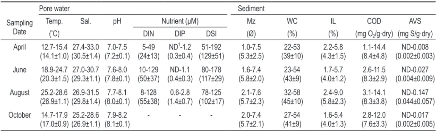
To understand the characteristics of sedimentary and benthic environments in habitats of naturally-occurring intertidal benthic macroalgae, various geochemical parameters of sediment (grain size, ignition loss [IL], chemical oxygen demand [COD], and acid volatile sulfur [AVS]) and pore water (temperature, salinity, pH, and nutrients) were measured in the southern intertidal zone of Hampyeong Bay at two month intervals from April to October 2009.
Ecological characteristics including the distribution and biomass of benthic macroalgae were also investigated.
Benthic macroalgae were distributed below 4 to 5 m depth from mean sea level near the lower portion of the intertidal zone where air exposure time is relatively short. The distribution area and biomass of benthic macroalgae gradually decreased during the study period. The surface sediments in the benthic algal region were mainly composed of finer sediments, such as slightly gravelly mud and mud. The temperature, salinity, pH, and nutrient concentrations (except dissolved inorganic nitrogen) in pore water did not differ in regions with and without benthic macroalgae, whereas the mean grain size and the concentrations of IL, COD, and AVS in sediments were much higher in regions harboring benthic macroalgae. The correlation between mean grain size and IL in sediments displayed two distinct gradients and the slope was much steeper in regions harboring benthic macroalgae, indicating that the content of organic matter in benthic algal region is not solely dependent on mean grain size. Our results indicate that the benthic macroalgae in the southern intertidal zone of Hampyeong Bay play an important role in the accumulation of organic matter in sediment.
Key words: Intertidal zone, Sediment, Pore water, Benthic macro algae, Hampyeong Bay
Sedimentary and Benthic Environment Characteristics in Macroalgal Habitats of the Intertidal Zone in Hampyeong Bay
Dong-Woon Hwang * and Byoung-Seol Koh
1Marine Environment Research Division, National Fisheries Research & Development Institute, Busan 619-705, Korea
1
Marine Ecosystem Management Team, Korea Marine Environment Management Corporation, Seoul 135-870, Korea 황동운*·고병설
1국립수산과학원 어장환경과, 1해양환경관리공단
서 론
우리나라의서해안과남해안은약
18,000
년전마지막빙하 기이후홀로세해침(Holocene Transgression)
에의해리아스 식해안과반폐쇄적인내만,
하구등다양한연안환경이형성 되었고,
특히지속적으로부유물질이공급되고해수의흐름 이약한하구역이나반폐쇄적인내만해역을중심으로넓고평 탄한조간대(intertidal zone)
가발달하였다(Ryu et al., 1997;
1998).
이들조간대는조석에의한노출과침수를반복하며해양및대기환경의영향을받아퇴적물과공극수의지화학적특 성들이급격한변화를보이는곳이지만
,
다양한퇴적환경및 저서환경을바탕으로지구상에존재하는생물의약20%
가서식할만큼생물다양성이높은곳이다
(Chang, 2008; Hwang and Kim, 2011).
해조류
(macroalgae)
는해양에서식물플랑크톤과더불어중요한 기초생산자로서주로연안의수심이 얕은조하대나부 착기질이 있는경성암반조간대에서식하는 것으로알려져 있다
.
하지만,
해조류중녹조식물문(Chlorophyta)
갈파래과(Ulvaceae)
에속하는가시파래( Ulva prolifera)
는담수의영향 이많고해수의유동이적은오염되지않은연성조간대지역 에주로서식한다(Kang, 1968; Yoon et al., 2003).
이들가시파 래는과거우리나라에서동해안(Boo and Lee, 1986; Lee and Oh, 1986),
서해안(Kim et al., 1986),
남해안(Song, 1986)
및 제주도(Lee et al., 1986)
등전국적으로분포하였으나,
경제발Article history;
Received 8 June 2012; Revised 19 November 2012; Accepted 22 November 2012
*Corresponding author: Tel: +82. 51. 720. 2532 Fax: +82. 51. 720. 2515 E-mail address: [email protected]
Kor J Fish Aquat Sci 45(6) 694-703, December 2012 http://dx.doi.org/10.5657/KFAS.2012.0694 pISSN:0374-8111, eISSN:2287-8815
ⓒ The Korean Society of Fishereis and Aquatic Science. All rights reserved
함평만 해조류 서식지내 해양환경 특성
695
전에따른임해공업단지의조성으로연안해역에도시의생활 하수와산업오폐수등이유입되면서
,
그분포지역은감소하여 현재에는장흥,
완도,
무안등전남남서해안의일부청정지역 에출현하는것으로보고되고있다(Yoon et al., 2003).
가시파래는매생이
( Capsosiphon fulvescens)
와더불어요오 드,
칼슘등의미네랄이풍부하고단백질,
아미노산,
비타민등 이많아영양가가높다(Choi et al., 2002).
최근건강에대한국 민들의인식이증진되어웰빙식품을선호하면서가시파래를 찾는수요또한증가하고있다.
가시파래는수온15℃
에서엽 체가성숙되어포자를방출하고지속적인성장을위한최적온 도는10℃
전후이며(Yoon et al., 2000),
연안역에연중분포하 지만주로봄철(3-4
월)
에번무한다.
또한,
가시파래의생산량 은가시파래가주로성장을하는추계와동계의해수온도와 강수량에의존하는데,
즉강수량이적고수온이낮을수록이듬해생산량이증가하는것으로알려져있다
(Ohno and Miya-
noue, 1980; Yoon et al., 2003).
하지만,
가시파래는어업인들 의소득증대를위한해조류양식품종으로서그중요성에대한 인식이부족하고,
현재일부지역에서자연적인채묘에의한소 규모양식에의존하고있어그생산량이많지않다.
최근
,
가시파래의대량생산을통한어업인의소득증대를위 하여가시파래의자연채묘에의한양식(Ohno, 1993)
및배우 자방출과접합자배양등의발생학적연구(Yoon et al., 2000)
와인공종묘생산기술및양성방법개발을위한연구
(Yoon et
al., 2003)
가진행되었다.
또한,
지금까지가시파래의계통·
분 류학적연구와발생형태및생태학적특성등생물학적기초 연구에대해서국내·
외의많은 연구자들에의해연구되었으 며(Ohno and Miyanoue, 1980; Lee et al., 1986; Kim et al.,
1991),
가시파래의식품학적특성에대한연구도일부수행되었다
(Okano et al., 1983; Choi et al., 2002).
하지만,
이러한가 시파래의생물학적기초연구및양식기술개발연구에비해서 식처의환경특성에대한연구는전무한실정이다.
따라서
,
이연구에서는해조류인가시파래가발생하는조간 대의퇴적환경및저서환경특성을파악하고자가시파래가연 중출현하는함평만을연구지역으로선정하여조간대지형,
해 조류분포면적및생물량,
그리고퇴적물과공극수의지화학적 특성을나타내는여러가지인자들에대하여조사하였다.
재료 및 방법 연구지역
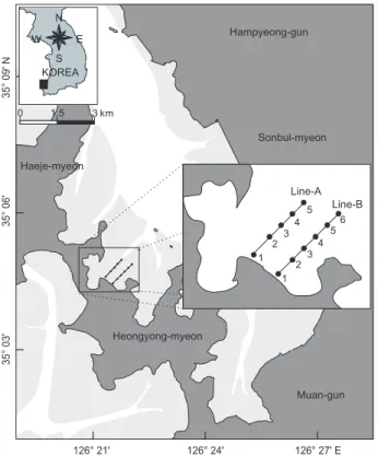
연구지역인함평만은한반도남서쪽의북위
35° 00′-35° 15′,
동경126° 15′-126° 30′
사이에있는북서-
남동방향으로길게 뻗어있는형태를가진반폐쇄적인내만이다(Fig. 1).
만의전체 적인크기는길이17 km,
최대폭12 km
로우리나라에서도비 교적큰만에속하고,
만의북서쪽에폭약1.8 km,
최대수심23 m
인만입구가위치하고있다(Ryu et al., 1999; Cho et al.,
2001; Kim et al., 2005).
만입구에서북서-
남동방향으로수 심10-20 m
사이의U
자형의주조류로(tidal channel)
가형성 되어있고,
주조류로양쪽에는좁은폭을가진수심5-10 m
정 도의작은조류로와이들가장자리에수심3 m
이내의얕은조 간대가넓게발달해있다.
조간대의폭은1-4.5 km
정도로매우 길며,
그면적은49.6 km
2로전체함평만면적의50%
이상을 차지하고있다(Kim and Chang, 1998; Lee and Jun, 2009).
또 한,
조간대내에는크고작은조간대사주(intertidal sand bar),
조류세곡(tidal creek)
등이혼재해있다(Ryu et al., 1998; Lee and Jun, 2009)
만의북서쪽에위치한좁은입구로인해외해수와만내해수 의교환은제한적이며
,
만내에발달한많은조류로와넓은조 간대로인해연구지역내해수의유동은매우복잡하다.
전반 적으로강한바람과매일불규칙적인조석에큰영향을받는 데,
조류의방향은창조시남동방향,
낙조시북동방향의흐름 을보이고,
조류의유속은만의입구쪽에서 창조시125 cm/
s,
낙조시138 cm/s
로서낙조우세환경을보인다(Ryu et al., 1999; Cho et al., 2001).
조석은일조부등(diurnal ineqaulity)
이심한반일주조석(semidiurnal tide)
으로서,
소조차는205.4 cm,
대조차는425.3 cm,
평균조차는약315 cm
이며, Da- vies(1964)
의분류기준에의하면중조차(mesotide)
환경에해 당된다(Ryu et al., 1999; Chu et al., 2000).
Distribution No distribution
lgnition Loss (%)
Mean Grain Size (Ø)
y = 0.58 x 1.11 r = 0.88 G=gravel
sG=sandy gravel msG=muddy sandy gravel gM=gravelly mud gmS=gravelly muddy sand gS=gravelly sand (g)M=slightly gravelly mud (g)mS=slightly gravelly muddy sand (g)S=slightly gravelly sand M=mud
sM=sandy mud mS=muddy sand S=sand
GRAVEL G
mG
gM (g)M sM M
MUD
1:9 Mud:Sand5:5 9:1SAND CLAY
2:1 Clay:SiltSILT
trace 0.01%
5%
30%
80%
90%
50%
10%
Percent Gravel
mS C M Z
sC sM sZ
cS S
mS zS
(g)mS (g)S S
gmS gS
msG sG
SAND
y = 2.65 x -13.35 r = 0.64
S=sand cS=clayey sand mS=muddy sand zS=silty sand sC=sandy clay sM=sandy mud sZ=sandy silt C=clay M=mud Z=silt
10
8
6
4
2
00 2 4 6 8
April June August October
1
2 3
4 5
1 2
3 4
5 6
1 2
3 4
5
1 2
3 4
5 6
1 2
3 4
5
1 2
3 4
5 6
1 2
3 4
5
1 2
3 4
5 6 April 2009
Benthic algae (Area : 0.41km
2) Benthic algae (Area : 0.38km
2)
Benthic algae (Area : 0.34km
2) Benthic algae (Area : 0.29km
2)
June 2009
August 2009 October 2009
Line-A
Line-B
Line-A
Line-B
Line-A
Line-B
Line-A
Line-B
Elevation relative to MS L (m)
Distance from coastline (m)
0 0 -1 -2 -3 -4 -5 -6
-7 100 200 300 400 500 600 700 800 900 1000 1100 1200 13001400 0
-1 -2 -3 -4 -5 -6 -7
1
1
2
2 3
3 4
4 5
5 6
No Distribution Distribution
Transect A
MSL MSL
Transect B -
1 234 5 1
2 34 5 6
0 1.5 3 km
S KOREA
Hampyeong-gun
Sonbul-myeon
Heongyong-myeon Haeje-myeon
Muan-gun Line-A
Line-B E
W N
35° 09' N35° 06'
126° 21' 126° 24' 126° 27' E
35° 03'
Station No.
Percentage (%)
A1 100
80 60 40 20
0 A2 A3 A4 A5 B1 B2 B3 B4 B5 B6
Gravel Sand Silt Clay
Fig. 1. A map showing the location of study area and the sampling sites for collecting the intertidal sediment and pore water in the southern part of Hampyeong Bay from April to October 2009.
황동운·고병설
696
만내담수의유입은주변에큰강이없어작은하천을통해 유입되고있으나그양은미미하며
(Lee and Jun, 2009),
강수 량은연평균약1,100 mm
로서주로여름철(6-8
월)
에집중된 다.
풍속은연평균4.2 m/s
로겨울에는한랭건조한북서풍이,
여름에는고온다습한남풍계열의바람이우세하다(Ryu et al.,
1999).
만내표층퇴적상은조립질퇴적물의경우만입구와수로부근
,
만안쪽내측조간대에우세하고세립질퇴적물은수 로양측면조간대에우세하게분포한다(Ryu et al., 1998).
만의북측해안에는
100-400 m
고도의비교적높은산들이위치해있고
,
만의안쪽남동해안에는고도가낮은구릉과평지가 발달해있다.
함평만주변의지질은중생대쥬라기편마상화강 암(gneissose grantie)
과시대미상의화강암질편마암(granitic gneiss),
반상변정편마암(porphyroblastic gneiss)
으로이루어 져있으며,
만의중앙부를경계로북서부일대는편마상화강암 이분포하고남동부일대는화강암질편마암이,
그리고이들사 이에는소규모의반상변정편마암이혼재해 있다(Ryu et al., 1998; 1999).
조사항목 및 분석방법
전남서부함평만내조간대해조류분포지역의퇴적환경및 저서환경특성을파악하기위하여
2009
년4-10
월사이에2
개 월간격으로함평만남부마산리조간대내2
개의측선을선정 하여해조류분포지역과비분포지역으로나누어총11
개정점 에서퇴적물및공극수시료를채취하였다(Fig. 1).
퇴적물시 료는표층0-2 cm
내의퇴적물만을고밀도폴리에틸렌병(high density polyethylene bottle)
에담아냉장및냉동상태로보관 하여실험실로운반한후입도(grain size)
와강열감량(igni- tion loss, IL),
화학적산소요구량(chemical oxygen demand, COD),
산휘발성황화물(acid volatile sulfide, AVS)
을Hwang et al. (2010)
이실시한방법에따라분석하였다.
공극수시료는퇴적물채취정점주변에작은구멍을만들어
고이는물을채취하여수온과염분은휴대용염분계
(Oakion,
Model Salt 6 and Hach, Model Sension 5),
그리고pH
는휴대 용pH
센서(Oakion, Model pHTestrs 20)
를이용하여현장에 서측정하였으며,
영양염류(NO
3--N, NO
2--N, NH
4+-N, PO
43-P, Si(OH)
4)
는25 mm GF/F
여과지와주사기형여과세트를이용 하여현장에서여과한후냉동상태로보관하여실험실로옮겨 영양염자동분석기(Alliance, Model INTEGRAL FUTURA and Seal analytical GmbH, Model QUAATRO)
로분석하였 다.
여기서 질산질소(NO
3--N),
아질산질소(NO
2--N),
암모니 아질소(NH
4+-N)
의합을 용존무기질소(dissolved inorganic nitrogen, DIN),
인산인(PO
43--P)
은용존무기인(dissolved in- organic phosphorus, DIP),
규산규소(Si(OH)
4)
는용존무기규 소
(dissolved inorganic silicate, DSi )
로정의하였다.
조간대의지형적특성을파악하기위한지형조사는
2009
년4
월에해안선부근에기준점을선정한후2
개의측선을따라광파거리측정기
(Topcon, Model GTS-751)
를사용하여지형적 인변화를보이는지점의고도를측정하는방법으로행하였다.
여기서,
지형조사를위해사용한기기는3 km
의수평거리에± 2 mm
의고도오차를보이는것으로알려져있다.
이와함께 해조류분포지역의면적은퇴적물과공극수의측선조사시기 에휴대용GPS(Garmin, Model GPS-5)
를이용하여해조류가 분포하는가장자리를따라도보로이동하면서위경도좌표를 알아낸후실험실에서그이동경로를연결하여면적을산출하였다
.
해조류의생물량은40 cm×40 cm
크기의방형구를이용하여방형구내에출현한해조류를모두채집한후실험실로 옮겨이온교환수로퇴적물을제거한다음건조기에넣고
40℃
에서건조하여항량을구하였으며이를단위면적당건중량으 로환산하였다
.
결과 및 고찰 해조류 분포면적 및 생물량 변화
함평만주변에는산업시설이나마을이발달하지않아오염원 이거의없고
,
많은양의유량을가진하천이존재하지않아담 수의유입이적음에도불구하고해조류인가시파래가여름철 일정기간을제외한연중분포한다.
따라서,
이연구가진행된 함평만남부마산리조간대내해조류의분포면적및생물량변 화를살펴보았다.
2009
년4
월부터10
월까지해조류분포지역의면적은4
월에0.41 km
2, 6
월에0.38 km
2, 8
월에0.34 km
2, 10
월에0.29 km
2 로4
월에서10
월로갈수록그면적은점차감소하는경향을보 였으며, 10
월의경우4
월의초기관측시보다30%
정도해조 류의분포면적이작았다(Fig. 2).
해조류의생물량또한, 4
월 에43.8 g dry-wt/m
2(246 g wet-wt/m
2)이었으나, 6
월에37.2 g dry-wt/m
2(215 g wet-wt/m
2), 8
월에35.1 dry-wt/m
2(201 g wet-wt/m
2), 10
월에33.9 g dry-wt/m
2(192 g wet-wt/m
2)
로초기관측시보다약
20%
정도감소하였다.
이러한가시파래의분포면적및생물량변화는이들의생태학적특징과밀접한관 련이있는것으로보인다
.
즉,
가시파래의경우환경변화에매 우민감하여작은오염에도장애를받고지속적인성장을위해 서10℃
의전후의온도가필요한데(Yoon et al., 2000, 2003),
봄철 이후강한일조량과증가한강수량에 의한육상으로부 터하천혹은지하수를통한담수의유입으로함평만내해수 의수온이상승하고염분이감소하면서서식환경이바뀌어그 면적및생물량이변화하는것으로보인다.
실제,
이연구기간 동안퇴적물내공극수중수온,
염분, pH
는4
월에각각12.7- 15.4℃, 27.4-33.0, 7.0-7.5
범위였으나, 8
월에는각각25.2-28.6
℃, 26.9-31.5, 7.7-8.1
범위로큰변화를보였으며(Table 1),
이연구와비슷한시기에진행된
2009
년국립수산과학원에서조사한함평만주변해수중수온과염분또한
5
월에수온16.3-
18.2℃,
염분은32.0-32.2
범위였으나, 8
월에는수온24.7-26.8
함평만 해조류 서식지내 해양환경 특성
697
℃,
염분은30.0-30.8
범위로가시파래가성장하기에적합하지않은환경이었다
(NFRDI, 2010).
해조류 분포지역의 조간대 지형
함평만주변의해안은대부분높이
10 m
미만의불안전한토양층이나연약한풍화암층을가진해안절벽
(sea cliff)
으로급 경사면을이루고있으며,
여름철높은해수면의상승과겨울철폭풍및계절풍의영향으로매우활발한침식을받고있다
(Lim
et al., 2002).
함평만의경우창조시간이낙조시간보다약1
시 간정도길기때문에(Lee and Jun, 2009),
이러한침식작용에 의해발생한퇴적물은외해로빠져나가지못하고대부분함평 만내측조간대에집적될수있으며,
실제함평만조간대는연평균집적률이
3.7 mm/yr
로서퇴적작용이우세하게나타난다(Ryu et al., 1999).
특히,
조간대에조석작용에의해형성된조 류로는이들퇴적물의이동통로로서퇴적물의이동,
분산및 집적에매우중요한역할을한다(Wells et al., 1990).
따라서,
연구지역인함평만남부마산리조간대의해조류분포지역주 변의수리환경특성및퇴적양상에대한이해를돕기위해지 형변화를살펴보았다
.
2009
년4
월함평만남부마산리조간대에서해조류분포지역 내2
개의측선을선정하여그지형단면조사하였으며,
그결과 를Fig. 3
에도시하였다.
측선A
의경우,
전연구지역이평균해 수면(mean sea level, MSL)
아래에존재하였으며,
해안가로부터간조선방향으로약
150 m
까지급경사를보이다200 m
바깥쪽으로는완만한경사를보였다
.
특히, 150-400 m
사이에는 크고작은조류세곡이발달해있었으며,
약600 m
와900 m
부 근에깊이5 m
이상의깊고넓은조류로가존재하였다.
여기서,
900 m
부근의조류로는600 m
부근의조류로보다훨씬깊고넓어도보로서의지형조사는불가능하여추가적인조사는이 루어지지않았다
.
측선B
또한측선A
와유사하게전연구지역 이평균해수면아래에존재하였고,
해안가에서부터간조선방향으로약
250 m
까지급경사를이루다그이후부터다소완만한경사를보였다
.
하지만,
측선A
와달리450-650 m
사이에의Distribution No distribution
lgnition Loss (%)
Mean Grain Size (Ø)
y = 0.58 x 1.11 r = 0.88 G=gravel
sG=sandy gravel msG=muddy sandy gravel gM=gravelly mud gmS=gravelly muddy sand gS=gravelly sand (g)M=slightly gravelly mud (g)mS=slightly gravelly muddy sand (g)S=slightly gravelly sand M=mud
sM=sandy mud mS=muddy sand S=sand
GRAVEL G
mG
gM (g)M sM M
MUD
1:9 Mud:Sand5:5 9:1SAND CLAY
2:1 Clay:SiltSILT
trace 0.01%
5%
30%
80%
90%
50%
10%
Percent Gravel
mS C M Z
sC sM sZ
cS S
mS zS
(g)mS (g)S S
gmS gS
msG sG
SAND
y = 2.65 x -13.35 r = 0.64
S=sand cS=clayey sand mS=muddy sand zS=silty sand sC=sandy clay sM=sandy mud sZ=sandy silt C=clay M=mud Z=silt
10
8
6
4
2
00 2 4 6 8
April June August October
1
2 3
4 5
1 2
3 4
5 6
1 2
3 4
5
1 2
3 4
5 6
1 2
3 4
5
1 2
3 4
5 6
1 2
3 4
5
1 2
3 4
5 6 April 2009
Benthic algae (Area : 0.41km
2) Benthic algae (Area : 0.38km
2)
Benthic algae (Area : 0.34km
2) Benthic algae (Area : 0.29km
2)
June 2009
August 2009 October 2009
Line-A
Line-B
Line-A
Line-B
Line-A
Line-B
Line-A
Line-B
Elevation relative to MS L (m)
Distance from coastline (m)
0 0 -1 -2 -3 -4 -5 -6
-7 100 200 300 400 500 600 700 800 900 1000 1100 1200 13001400 0
-1 -2 -3 -4 -5 -6 -7
1
1
2
2 3
3 4
4 5
5 6
No Distribution Distribution
Transect A
MSL MSL
Transect B -
1 234 5 1
234 5 6
0 1.5 3 km
S KOREA
Hampyeong-gun
Sonbul-myeon
Heongyong-myeon Haeje-myeon
Muan-gun Line-A
Line-B E
W N
35° 09' N35° 06'
126° 21' 126° 24' 126° 27' E
35° 03'
Station No.
Percentage (%)
A1 100
80 60 40 20
0 A2 A3 A4 A5 B1 B2 B3 B4 B5 B6
Gravel Sand Silt Clay
Fig. 2. The temporal variations of benthic macro algae distribution in the southern intertidal zone of Hampyeong Bay from April to October 2009. The distribution areas of benthic macro algae gradually decreased during the study periods.
황동운·고병설
698
비교적평탄한지형이나타날뿐조간대곳곳에많은조류세곡 과조류로가발달해있었다
.
한편
, 2009
년4
월에해조류는측선A
의경우해안가로부터 약100-180 m, 200-600 m,
그리고650-900 m
사이에,
즉,
전체적으로해안가와큰조류로를제외한
MSL
로부터약4-5 m
아래의비교적평탄한지역에해조류가분포하고있었다
.
측선B
의경우에도해안가와큰조류로를제외한MSL
아래약4-5 m
깊이에해조류가분포하였으나, A
측선과달리해안가로부 터약200 m
부근과250-400 m, 600-800 m, 900-1,100 m,
그 리고약1,200 m
부근의일부지역에번무하고있었다.
따라서,
해조류가분포하는지역과분포하지않는지역의퇴적및저서 환경차이를보기위해측선A
의경우총5
개정점(
분포지역- A2, A3, A4 ;
비분포지역- A1, A5),
측선B
의경우총6
개정 점(
분포지역- B2, B4, B5 ;
비분포지역- B1, B3, B6)
을선정 하여퇴적물과공극수시료를채취하여지화학적특성을나타 내는여러가지요인들을살펴보았다.
퇴적물의 입도 및 유기물 함량 특성
함평만남부마산리조간대의퇴적환경특성을살펴보기위 하여조사한각시기별퇴적물중평균입도
(mean grain size, Mz), WC, IL, COD, AVS
분석결과를에나타내었다
.
퇴적 물의입도분석결과,
연구기간내퇴적물중자갈은0-27.7% (
평균4.9±8.1%),
모래는0.3-63.1% (
평균18.6±22.1%),
실트와점토는각각
8.8-72.9% (
평균59.0±25.3%), 5.1-40.7%
(
평균24.5±11.2%)
범위였다(Fig. 4).
해안가부근의조간대 상부인A1
과B1
그리고B3
정점을제외한모든지역에서실트와점토의함량이
70%
이상으로세립한퇴적물이우세하였다
.
각시기별조사정점에따른자갈,
모래,
실트,
점토함량을 기초로Folk (1968)
의삼각좌표에도시한결과,
연구기간동 안퇴적물은역니질사(gravelly muddy sand, gmS),
약역니질 사(slightly gravelly muddy sand, (g)mS),
약역질니(slightly gravelly mud, (g)M),
니(mud, M),
역질니(gravelly mud, gM),
실트(silt, Z),
니(mud, M)
의총7
개퇴적물유형(sedimentary type)
으로나타났다(Fig. 5).
이러한결과를바탕으로퇴적물의 조직특성에따라퇴적상(sedimentary facies)
은약역질니((g) M),
역니질사(gmS),
실트(Z)
인총3
개의퇴적상으로구분되었 다.
약역질니퇴적물은양측선의조간대중앙부와간조선부근 인A2, A3, B2, B3, B5, B6
정점에서나타나고역니질사퇴적 물은퇴적물은양측선의조간대상부지역인A1, B1
정점그리고실트퇴적물은주로
A
측선의간조선부근인A4, A5
정점과B4
정점에우세하게분포하였다.
입도분석결과를바탕으로
Folk and Ward (1957)
계산식에 의하여구한퇴적물의통계학적특성을나타내는Mz
는연구기 간내1.0-7.7 Ø (
평균5.6±2.1 Ø)
범위로조립사(coarse sand)
와세립실트(fine silt)
사이였다(Table 1).
그러나,
해안가부근 의조간대상부지역인A1, B1
정점을제외하면,
모든시기에 연구지역내퇴적물은조립실트(coarse silt, 6.0 Ø)
와세립실트(fine silt, 8.0 Ø)
사이였으며전반적으로는중립실트(medium silt, 7.0 Ø)
가우세하였다(Table 1).
또한,
전체적으로퇴적물 은연구기간동안조간대상부지역인A1, B1
정점과A
측선의 간조선부근의A4, A5
정점에서4
월부터10
월까지시간이지 날수록다소세립해지는경향을보인반면,
조간대중부지역인A2, A3, B2, B3
정점부근에서는다소조립해지는경향을보였다
.
이는여름철해수면상승과태풍으로인해연구지역주 변의조간대중부지역에서재부유한세립질퇴적물들이외해Distribution No distribution
lgnition Loss (%)
Mean Grain Size (Ø)
y = 0.58 x 1.11 r = 0.88 G=gravel
sG=sandy gravel msG=muddy sandy gravel gM=gravelly mud gmS=gravelly muddy sand gS=gravelly sand (g)M=slightly gravelly mud (g)mS=slightly gravelly muddy sand (g)S=slightly gravelly sand M=mud
sM=sandy mud mS=muddy sand S=sand
GRAVEL G
mG
gM (g)M sM M
MUD
1:9 Mud:Sand5:5 9:1SAND CLAY
2:1 Clay:SiltSILT
trace 0.01%
5%
30%
80%
90%
50%
10%
Percent Gravel
mS C M Z
sC sM sZ
cS S
mS zS
(g)mS (g)S S
gmS gS
msG sG
SAND
y = 2.65 x -13.35 r = 0.64
S=sand cS=clayey sand mS=muddy sand zS=silty sand sC=sandy clay sM=sandy mud sZ=sandy silt C=clay M=mud Z=silt
10
8
6
4
2
00 2 4 6 8
April June August October
1
2 3
4 5
1 2
3 4
5 6
1 2
3 4
5
1 2
3 4
5 6
1 2
3 4
5
1 2
3 4
5 6
1 2
3 4
5
1 2
3 4
5 6 April 2009
Benthic algae (Area : 0.41km
2) Benthic algae (Area : 0.38km
2)
Benthic algae (Area : 0.34km
2) Benthic algae (Area : 0.29km
2)
June 2009
August 2009 October 2009
Line-A
Line-B
Line-A
Line-B
Line-A
Line-B
Line-A
Line-B
Elevation relative to MS L (m)
Distance from coastline (m)
0 0 -1 -2 -3 -4 -5 -6
-7 100 200 300 400 500 600 700 800 900 1000 1100 1200 13001400 0
-1 -2 -3 -4 -5 -6 -7
1
1
2
2 3
3 4
4 5
5 6
No Distribution Distribution
Transect A
MSL MSL
Transect B -
1 234 5 1
2 34 5 6
0 1.5 3 km
S KOREA
Hampyeong-gun
Sonbul-myeon
Heongyong-myeon Haeje-myeon
Muan-gun Line-A
Line-B E
W N
35° 09' N35° 06'
126° 21' 126° 24' 126° 27' E
35° 03'
Station No.
Percentage (%)
A1 100
80 60 40 20
0 A2 A3 A4 A5 B1 B2 B3 B4 B5 B6
Gravel Sand Silt Clay
Fig. 3. Schematic diagrams represent the cross-sections of topography and the sampling locations from shoreline to low sea level at transects A (upper) and B (lower) in the southern part of Hampyeong Bay. The filled and opened bars represent the distribution and no distribution areas of benthic macro algae at transects A and B, respectively.
Distribution No distribution
lgnition Loss (%)
Mean Grain Size (Ø)
y = 0.58 x 1.11 r = 0.88 G=gravel
sG=sandy gravel msG=muddy sandy gravel gM=gravelly mud gmS=gravelly muddy sand gS=gravelly sand (g)M=slightly gravelly mud (g)mS=slightly gravelly muddy sand (g)S=slightly gravelly sand M=mud
sM=sandy mud mS=muddy sand S=sand
GRAVEL G
mG
gM (g)M sM M
MUD
1:9 Mud:Sand5:5 9:1SAND CLAY
2:1 Clay:SiltSILT
trace 0.01%
5%
30%
80%
90%
50%
10%
Percent Gravel
mS C M Z
sC sM sZ
cS S
mS zS
(g)mS (g)S S
gmS gS
msG sG
SAND
y = 2.65 x -13.35 r = 0.64
S=sand cS=clayey sand mS=muddy sand zS=silty sand sC=sandy clay sM=sandy mud sZ=sandy silt C=clay M=mud Z=silt
10
8
6
4
2
00 2 4 6 8
April June August October
1
2 3
4 5
1 2
3 4
5 6
1 2
3 4
5
1 2
3 4
5 6
1 2
3 4
5
1 2
3 4
5 6
1 2
3 4
5
1 2
3 4
5 6 April 2009
Benthic algae (Area : 0.41km
2) Benthic algae (Area : 0.38km
2)
Benthic algae (Area : 0.34km
2) Benthic algae (Area : 0.29km
2)
June 2009
August 2009 October 2009
Line-A
Line-B
Line-A
Line-B
Line-A
Line-B
Line-A
Line-B
Elevation relative to MS L (m)
Distance from coastline (m)
0 0 -1 -2 -3 -4 -5 -6
-7 100 200 300 400 500 600 700 800 900 1000 1100 1200 13001400 0
-1 -2 -3 -4 -5 -6 -7
1
1
2
2 3
3 4
4 5
5 6
No Distribution Distribution
Transect A
MSL MSL
Transect B -
1 234 5 1
2 34 5 6
0 1.5 3 km
KOREAS
Hampyeong-gun
Sonbul-myeon
Heongyong-myeon Haeje-myeon
Muan-gun Line-A
Line-B E
W N
35° 09' N35° 06'
126° 21' 126° 24' 126° 27' E
35° 03'
Station No.
Percentage (%)
A1 100
80 60 40 20
0 A2 A3 A4 A5 B1 B2 B3 B4 B5 B6
Gravel Sand Silt Clay
Fig. 4. The average percentage composition of gravel, sand, silt, and clay in intertidal surface sediment in the southern part of Hampyeong Bay during the study periods.