The Cases of International Standardization of Sea Names and Their Implications for Justifying the Name East Sea*
Sungjae Choo**
바다 이름의 국제적 표준화 사례와 동해 표기 정당화에의 시사점*
주성재**
Abstract:This study aims to categorize and analyze internationally standardized sea names based on their origins.
Especially noting the cases of sea names using country names and dual naming of seas, it draws some implications for complementing logics for restoring the name East Sea. Of the 110 names for 98 bodies of water listed in the book titled Limits of Oceans and Seas, the most prevalent cases are named after adjacent geographical features; followed by commemorative names after persons, directions, and characteristics of seas. These international practices of naming seas are contrary to Japan’s argument for the principle of using the name of archipelago or peninsula. There are several cases of using a single name of country in naming a sea bordering more than two countries, with no serious disputes.
This implies that a specific focus should be given to peculiar situation that the name East Sea contains, rather than the negative side of using single country name. In order to strengthen the logic for justifying dual naming, it is suggested, an appropriate reference should be made to the three newly adopted cases of dual names, in the respects of the history of the surrounding region and the names, people’s perception, power structure of the relevant countries, and the process of the standardization of dual names. In order to endow East Sea with the meaning of the east of the Eurasian continent, westerners’ perception on the Far East should be elaborated in more detail.
Key Words : sea names, international standardization, East Sea, country name, dual naming, Limits of Oceans and Seas
요약:이 연구는 국제적으로 표준화된 바다 이름을 그 기원에 따라 분류하고 분석하는 것을 목적으로 한다. 특히 국가명을 사용하는
바다 이름과 두 개의 이름을 병기하는 경우에 주목하여 동해-일본해 이름을 둘러싼 논리를 평가하고자 한다. ‘해양과 바다의 경계’
책자에 수록된 98개 바다의 110개 이름을 분석한 결과, 인근 지리적 실체의 이름을 사용하는 경우가 가장 많으며, 다음으로 개인 이 름, 방위, 바다의 특성 등이 사용된 것을 알 수 있다. 이러한 다양한 기원의 바다 이름은 해양을 나누는 열도나 반도의 이름을 사용하 는 것이 일반적인 원칙이라고 하는 일본의 주장과 배치된다. 여러 국가에 접하고 있는 바다가 한 국가 이름을 사용하면서도 심각한 분쟁이 없는 경우가 많은 것은 단일 국가의 이름을 사용하는 것이 부당하다는 네거티브 방식의 주장보다는 동해 명칭의 강력한 상징 성을 강조하는 것이 더 바람직하다는 시사점을 준다. 병기의 필요성을 정당화하기 위해서는 최근 병기가 결정된 세 개의 사례로부터 해당 지역과 명칭의 역사적 배경, 인식, 관련 국가의 세력 구조, 병기의 과정 등의 측면에서 시사점을 찾는 것이 중요하다. 동해에 유 라시아의 동쪽이라는 의미를 부여하기 위해서는 극동지역에 대한 서양인들의 인식에 대한 연구가 선행되어야 함이 지적된다.
주요어:바다 이름, 국제적 표준화, 동해, 국가 이름, 병기, 해양과 바다의 경계
* This research was supported by the Kyung-Hee University Research Fund in 2005 (KHU-20050414).
** Associate Professor, Department of Geography, Kyung-Hee University, [email protected]
1. Introduction
The efforts for restoring the name East Sea have been focused on analyzing the use of names appearing in old maps for the concerned area and, based on these statistics, emphasizing the logic of having to use East Sea. Kim (2003) summarized that studies on the name East Sea have been progressed in three phases; i) collecting and analyzing western old maps in the 1970s and 1980s, ii) developing analytical models and theories in the 1990s, and iii) adopting and applying theoretical discussions in the 21st century.
In addition to this approach of studying old maps, it is required to extend the scope of study into the sphere of international standardization of geographical names. Persuasive logics should be developed in view of the objective principles of the standardization. This means an extension into the field of toponymy and development of diverse logics based on the toponymic studies with the subjects of sea names.
The principles of the international standardi- zation of geographical names, academically accumulated in the field of toponymy and practically recommended by international organizations dealing with geographical names, e.g. United Nations Conference on the Standardi- zation of Geographical Names (UNCSGN) or International Hydrographic Organization (IHO), have several facets. These include the issue of how long and how frequently a geographical name has been used, namely historical legitimacy issue (Munro, 2004; Atoui, 2004), the issue of who have used the geographical name in what territory, which is exonym and endonym issue (Kadmon, 1997; Kadmon, 2004; Adamic, 2004), and also the issue of which name would be adopted when more than two names coexist (Kadmon, 2004). Recently, discussions on the
meaning of geographical names as cultural heritage and the principles of commemorative naming after famous personnels are actively being made1).
These principles should be reviewed and fortified by several case studies of geographical names. This study aims to provide one of these case studies by listing sea names in the world and categorizing them into some classes of their origins. Especially noting the cases of sea names using country names and dual naming of seas, this study intends to draw some implications for supplying logic for the name East Sea, and find future research directions and strategies.
Before going into the discussion, it should be noted that examining origins of geographical names would not be an easy job. Sometimes, it is not eligible to find the ultimate origin of the name. When a name is shared by a city and a sea, the city name could have been adopted for referring to the sea, or the city with its formation could have used the name of its bordering sea.
When a sea was named after its adjacent region and the region name had its own origin, then it would be very difficult to determine the ultimate origin of the sea; whether the region name or its origin.
Moreover, there could be found very little literature telling the background or evidence of the origin of name. Therefore, many of the origins of geographical names would be very ambiguous in nature. Each one of the names should be studied one by one through literature review and field survey. These limitations were also coincided by former studies on maritime feature names by Murphy (1999) and Raper (2007).
Sea names used in this study are those listed in the book Limits of Oceans and Seas, which is called S-23, published by IHO. There are, of course, other sea names not listed in this publication, but used by people and maps all over the world. But this book deserves to be
recognized as an authoritative list of internationally standardized sea names. This study generally uses the third edition of this book published in 1953, the most recent authorized one, but also refers to a final draft of the fourth edition prepared in 2002. This draft is not yet approved by member states of IHO, mainly because of the disputes between Korea and Japan on the name of East Sea or Sea of Japan.
This study considers just specific names, not generic terms. Generic terms of bodies of water include not only sea and ocean, but also gulf, passage, strait, channel, bay, waters and bight.
Some are called by their transliterated or transcribed generic term, like Skagerrak where
‘rak’ means waterway or Seto Naikai where
‘naikai’ means inland sea. Despite the existence of these diverse generic terms, this study uses
‘sea’ as a common noun representing any kind of body of water.
In order to examine the origins of sea names, an extended search for encyclopedia by way of internet or printed books was made. When there are conflicts in explanation, the judgment of the origins should be inevitably subjective.
This paper consists of three parts. First, it begins with reviewing the current status of the disputes surrounding the name between the Korean Peninsula and the Japanese Archipelago.
From this review, debates in relation to the practices of naming seas are summarized.
Second, it analyzes sea names all around the world in terms of their origins. A specific note is given to the cases of sea names using country names and dual naming of seas. Third, attempts are made to evaluate the logics which have been used for arguing for the name East Sea, and according to this evaluation, some suggestions are provided.
2. Current Status of the Name East Sea versus Sea of Japan
1) Arguments of Japan and Korea2)
The Japanese government has recently changed its position to ignore the dispute surrounding the name East Sea or Sea of Japan and now extends offensive activities to actively persuade the legitimacy of the name Sea of Japan. From a series of booklets and movie pictures3), as well as strong counterargument at the international conferences, Japan’s arguments are summarized as follows.
• Sea of Japan with its long history is an established name. Sea of Japan has such a long history to appear in 1602 in an old map by Mateo Ricci. In the 17th to 18th centuries, the sea was called with various names, but in the late 18th to early 19th centuries, the name Sea of Japan began to be established by European explorers.
• Sea of Japan is appropriate in terms of principles of naming seas. The most frequently used method of naming sea areas separated from an ocean is to use the name of a major archipelagic arc or a peninsula that separates the sea area in question from the ocean.
Examples include Sea of Japan, Andaman Sea, Gulf of California, and Irish Sea.
• Sea of Japan is authorized by international organizations and used by most of world maps.
The United Nations confirms that Sea of Japan is the standard geographical term and it observes the prevailing practice of its single use. This single name has been continuously used by IHO and most of the textbooks, school atlases and commercially available maps.
The arguments of the Korean side can be
summarized as counterarguments against each of these.
• Various names were used in foreign old maps, but none of them was established. The name shows such a diversity to include Sea of Korea, East Sea, Eastern Sea, Oriental Sea, and Sea of Japan. Although the frequency of using Sea of Japan increased since the 1850s, this increase does not mean that it became an established name. A considerable number of maps still did not have a determined name for this sea area.
The name East Sea has been used for more than 2000 years and it has appeared in Korean old maps since 1531.
• There are diverse cases of naming seas.
Methods of naming seas include using direction from continent or country, naming after adjacent geographical feature, naming after explorer or discoverer, and expressing characteristics of sea. There are several cases which do not use the name of a major archipelagic arc or a peninsula that separates a sea area when naming the sea area separated from an ocean. Examples include Sea of Okhotsk, Bering Sea and North Sea. Experts point out that naming international bodies of water after nations or states is a particularly problematic practice (Murphy, 1999; 2005).
• Sea of Japan is not an authorized name and East Sea is now being recognized by world map-makers. It was critical for the widespread diffusion of the name Sea of Japan that IHO adopted the name in its first edition of Limits of Oceans and Seas in 1929. But IHO now recognizes the problem of its single use and recommends that Korea and Japan reach an agreement on a common name. The UN Secretariat admits that it is UN’s internal practice to use the most frequently used name, but also clarifies that this practice does not support for a specific name. In addition, many
major map-makers of the world have begun to use East Sea simultaneously with Sea of Japan.
In addition to these arguments, the Korean side extends the logics for reducing exonyms and for using dual names, basically depending on the resolutions of UNCSGN and IHO. The name Sea of Japan for the part of Korea is an exonym for Koreans and should be reduced to use (Choo, 2005b; Choo and Lee, 2005). On the basis of UN Resolution III/20 and IHO Technical Resolution A.4.2.6, it is argued, both names should be used when failing to agree on a common name4).
2) Debates in relation to the practices of naming seas
From the arguments of Japan and Korea, some debate points can be summarized exclusively in relation to the practices of naming seas.
First, Japan argues that the most frequently used way of naming sea areas separated from an ocean is to use the name of a major archipelagic arc or a peninsula that separates the sea area from the ocean. Korea takes examples not conforming to this argument.
Second, Korea argues that sea names using country names are very few, and even when this is the case, it would evoke whatever form of disputes between bordering countries. Japan does not extend any direct counterargument, but could implicitly use the logic of Japan’s position separating two bodies of water, as mentioned above.
Third, Korea strongly requests two names of East Sea and Sea of Japan should be used together because no agreement has been reached yet. It could be implied that there are many cases of dual naming of seas. Japan is against this request because dual naming may cause confusion in the international society.
Fourth, Japan points out the inappropriateness
of the name East Sea in that it contains direction from a specific country. In response to this point, Korea argues that East Sea is a translated name of Donghae, a long-standing proper noun, not a directional name. When direction is inherent, it would mean the east of the Eurasian continent.
These debate points are worth evaluating with international sea naming practices. We will be back to each of these points later in this paper.
3. The Cases of International Standardization of Sea Names
1) Origin of sea names
The third edition of the book Limits of Oceans and Seas lists ninety-eight bodies of waters in the world including all the sub-divisions. An analysis of this list shows that the origin of the name belongs to one of the following four categories;
direction, adjacent geographical feature, person name and characteristics. There are eleven names with two of these four categories combined, e.g.
East Siberian Sea or South China Sea. There is also one dual name which belongs to two different categories: Aegean Sea (The Archipelago).
Therefore, when double-counting is allowed, there are 110 cases of sea name origins which are internationally standardized.
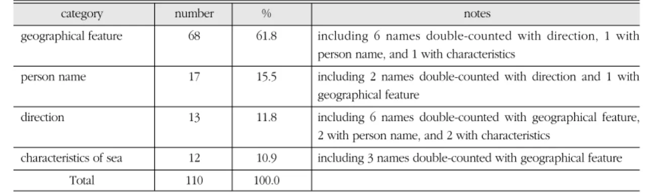
Of these 110 cases, the greatest part is occupied by those named after adjacent geographical features; 68 cases or 61.8% (Table 1). The second greatest category is commemorative names after explorers, saints or politicians; 17 cases or 15.5%.
This is followed by direction, 13 cases or 11.8%, and characteristics of seas, 12 cases or 10.9%.
Sea names using geographical features can be divided into four types; those names after port, city or region within a country, country, region across countries, and ethnic group (Table 2). As many as two-thirds of the sea names after geographical features, 42 cases, are using names of city, port or region smaller than a country.
Such port cities as Bristol (U.K.), Kara (Russia), Riga (Latvia), Suez (Egypt), such regions as Bothnia (Finland), Alaska (U.S.A.), Labrador (Canada), and such islands as Andaman (India), Timor (Indonesia), Sulu (Philippines), provided names for adjacent seas. Ancient names are sometimes used, like Ionian Sea (ancient Greek region), Adriatic Sea (old name of Venezia), and Malacca Strait (ancient Malaysian city).
Eighteen sea names originated from names of seventeen countries5). Most of the names came
Table 1. Categories of the origin of sea names
category number % notes
geographical feature 68 61.8 including 6 names double-counted with direction, 1 with person name, and 1 with characteristics
person name 17 15.5 including 2 names double-counted with direction and 1 with geographical feature
direction 13 11.8 including 6 names double-counted with geographical feature, 2 with person name, and 2 with characteristics
characteristics of sea 12 10.9 including 3 names double-counted with geographical feature
Total 110 100.0
Note: Twelve names out of ninety-eight sea divisions have dual origins. Therefore, 110 cases in total are analyzed.
Source: IHO, 1953, Limits of Oceans and Seas, third edition.
from one of the countries bordering the sea. One exception is Indian Ocean which is not bordered with India. Four names use adjacent regions across countries: Arctic Ocean was named after the Arctic, Baltic Sea after a legendary island of Baltia (or Balcia) which had existed across the countries near this region6), Bay of Bengal after the region of Bengal in the Gangetic delta waters, and Gulf of Guinea after the coastal region of Africa.
Those sea names using ethnic group names can be included under this category. Ethnic groups range from such large ones as Arabian and Caribbean to such minority groups as Tomini
(Indonesia) and Ligurian (ancient Italy).
There are seventeen seas named after persons (Table 3). These can be sub-divided into four types. More than half of the names originated from explorers of the U.K., Russia, Sweden and the Netherlands. Others include one admiral and two politicians, two saints, one hero in Etruscan mythology, and very exceptionally Greek god of giant, Atlas.
Among the thirteen sea names using directions, just three names are using directions only; North Sea, the Northwestern Passages and Mediterra- nean Sea, meaning north of the European Continent, northwestern passage of Canada and Table 2. Seas named after geographical features
type name
Source: IHO, 1953, Limits of Oceans and Seas, third edition.
Adriatic Sea Aegean Sea Alboran Sea Andaman Sea Balearic (Iberian Sea) Bali Sea
Banda Sea Bay of Biscay Bay of Fundy Bristol Channel Celebes Sea Ceram Sea Chuckchi Sea East Siberian Sea Flores Sea
Greenland Sea Gulf of Aden Gulf of Alaska Gulf of Aqaba Gulf of Boni Gulf of Bothnia Gulf of California Gulf of Riga Gulf of Suez Halmahera Sea Ionian Sea Java Sea Kara Sea Labrador Sea Laccadive Sea
Makassar Strait Malacca Strait Molukka Sea Savu Sea Sea of Azov Sea of Okhotsk Seto Naikai or Inland Sea Skagerrak
Strait of Gibraltar Sulu Sea
The Coastal Waters of Southeast Alaska and British Columbia Timor Sea port city or region within
a country (42)
Gulf of Finland Norwegian Sea English Channel Gulf of Mexico Gulf of Oman
Gulf of Iran (Persian Gulf) Inner Seas off the West Coast
of Scotland
Irish Sea and St. George’s Channel
Indian Ocean Mozambique Channel Singapore Strait Gulf of Thailand (Siam)
South China Sea (Nan Hai) Eastern China Sea (Tung Hai) Japan Sea
Philippine Sea Great Australian Bight Solomon Sea country
(18)
Arctic Ocean Baltic Sea
Bay of Bengal Gulf of Guinea region across countries
(4)
Arabian Sea Caribbean Sea
Gulf of Tomini Ligurian Sea ethnic group
(4)
middle of land, respectively (Table 4). Others include direction from a country, such as Inner Seas off the West Coast of Scotland, South China Sea, East China Sea, or direction from a region within a country, such as Seto Naikai, East Siberian Sea, and the Coastal Waters of Southeast Alaska and British Columbia. North and South Atlantic Oceans and North and South Pacific Oceans are dividing large oceans into parts.
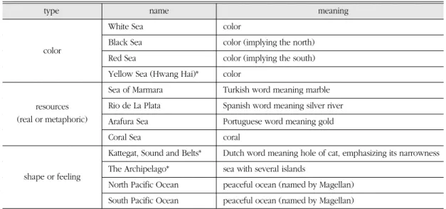
Twelve sea names originated from expressions of the characteristics of seas7) (Table 5). Four names, White Sea, Black Sea, Red Sea and Yellow Sea, express color. In some cultures, however, color does have meaning more than color itself. For example, ‘black’ in Black Sea might mean the north and ‘red’ in Red Sea might mean the south in the ancient civilization. This
came from the assignment of colors to the direction of the compass.
Four names express resources near the sea area, either real or metaphoric. ‘Marmara’ in Sea of Marmara is a Turkish word meaning marble and ‘Arafura’ in Arafura Sea is a Portuguese word meaning gold. Rio de La Plata is Spanish words meaning silver river. All these names, with Coral Sea, imply the abundance of each resource or metaphoric appearance of the sea area.
Four names originated from their shape or feeling. Kattegat is a Dutch word meaning the hole of cat, which emphasizes the narrowness of the waterway. The Archipelago, another name of Aegean Sea within bracket, express its characteristics of containing several islands.
Pacific Ocean, divided into north and south, was Table 3. Seas named after persons
type name origin of the name
Barentsz Sea name of Dutch explorer
Leptev Sea(or Nordenskjöld Sea)* name of Russian explorer(name of Swedish explorer)
Baffin Bay name of British explorer
Davis Strait name of British explorer
Hudson Bay name of British explorer
Hudson Strait name of British explorer
Bering Sea name of Russian explorer
Bass Strait name of British explorer
Tasman Sea name of Dutch explorer
Beaufort Sea name of British admiral
Lincoln Sea name of American politician
Bismarck Sea name of German politician
Irish Sea and St. George’s Channel* name of saint Gulf of St. Lawrence name of saint
Tyrrhenian Sea name of hero in Etruscan mythology North Atlantic Ocean name of Greek god Atlas
South Atlantic Ocean name of Greek god Atlas
Note: The names with asterisk have been changed in a final draft of the fourth edition (2002) into single names of Leptev Sea and Irish Sea.
Source: IHO, 1953, Limits of Oceans and Seas, third edition.
explorer
saint
god or hero in mythology admiral or politician
Table 4. Sea names using directions
type name meaning
North Sea north of the European Continent
The Northwestern Passages northwestern passage of Canada
Mediterranean Sea middle of land
Inner Seas off the West Coast of Scotland inner sea of Scotland South China Sea (Nan Hai)* sea in the south of China Eastern China Sea (Tung Hai)* sea in the east of China Seto Naikai or Inland Sea* inland sea of Japanese port Seto
East Siberian Sea sea in the east of Siberia
The Coastal Waters of Southeast Alaska and sea in the southeast of Alaska and
British Columbia British Columbia
North Atlantic Ocean northern part of Atlantic Ocean South Atlantic Ocean southern part of Atlantic Ocean North Pacific Ocean northern part of Pacific Ocean South Pacific Ocean southern part of Pacific Ocean
Note: The names with asterisk have been changed in a final draft of the fourth edition (2002) into single names of South China Sea, East China Sea and Seto Naikai.
Source: IHO, 1953, Limits of Oceans and Seas, third edition.
direction only
part of ocean direction from a country
direction from a region within a country
Table 5. Seas names expressing characteristics
type name meaning
White Sea color
Black Sea color (implying the north)
Red Sea color (implying the south)
Yellow Sea (Hwang Hai)* color
Sea of Marmara Turkish word meaning marble Rio de La Plata Spanish word meaning silver river Arafura Sea Portuguese word meaning gold
Coral Sea coral
Kattegat, Sound and Belts* Dutch word meaning hole of cat, emphasizing its narrowness The Archipelago* sea with several islands
North Pacific Ocean peaceful ocean (named by Magellan) South Pacific Ocean peaceful ocean (named by Magellan)
Note: The names with asterisk have been changed in a final draft of the fourth edition(2002). Hwang Hai, a transcribed name of Yellow Sea, was omitted. Kattegat, Sound and Belts was sub-divided into Kattegat, Lillebælt, Sound Sea and Storebælt. The Archipelago, another name of Aegean Sea within bracket, was deleted.
Source: IHO, 1953, Limits of Oceans and Seas, third edition.
color
shape or feeling resources (real or metaphoric)
named by Portuguese explorer Magellan who expressed the peacefulness of the ocean.
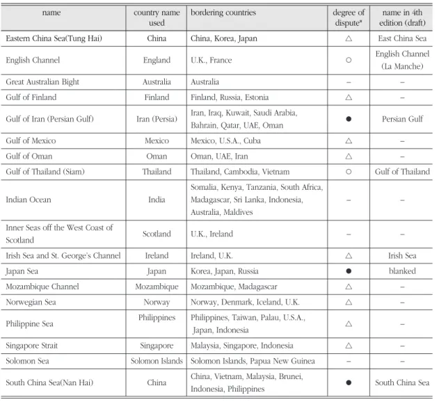
2) Sea names using country names and the degree of dispute
Let us look at the eighteen cases of sea names using country names in more detail. The seventeen countries whose names are adopted as
sea names include Australia, China, England, Finland, India, Iran (Persia), Ireland, Japan, Mexico, Mozambique, Norway, Oman, Philippines, Scotland, Singapore, Solomon Islands, and Thailand. Just one case, Great Australian Bight, borders one country, Australia. Most of the others are bordering two to four countries, and even eight to ten countries (Table 6).
According to Murphy (1999), three names are
Table 6. Sea names using country names
name country name bordering countries degree of name in 4th
used dispute* edition (draft)
Eastern China Sea(Tung Hai) China China, Korea, Japan △ East China Sea
English Channel England U.K., France ○ English Channel
(La Manche)
Great Australian Bight Australia Australia – –
Gulf of Finland Finland Finland, Russia, Estonia △ –
Gulf of Iran (Persian Gulf) Iran (Persia) Iran, Iraq, Kuwait, Saudi Arabia,
● Persian Gulf Bahrain, Qatar, UAE, Oman
Gulf of Mexico Mexico Mexico, U.S.A., Cuba △ –
Gulf of Oman Oman Oman, UAE, Iran △ –
Gulf of Thailand (Siam) Thailand Thailand, Cambodia, Vietnam ○ Gulf of Thailand Somalia, Kenya, Tanzania, South Africa,
Indian Ocean India Madagascar, Sri Lanka, Indonesia, – –
Australia, Maldives Inner Seas off the West Coast of
Scotland U.K., Ireland – –
Scotland
Irish Sea and St. George’s Channel Ireland Ireland, U.K. △ Irish Sea
Japan Sea Japan Korea, Japan, Russia ● blanked
Mozambique Channel Mozambique Mozambique, Madagascar △ –
Norwegian Sea Norway Norway, Denmark, Iceland, U.K. △ –
Philippine Sea Philippines Philippines, Taiwan, Palau, U.S.A.,
△ –
Japan, Indonesia
Singapore Strait Singapore Malaysia, Singapore, Indonesia △ –
Solomon Sea Solomon Islands Solomon Islands, Papua New Guinea – –
South China Sea(Nan Hai) China China, Vietnam, Malaysia, Brunei,
● South China Sea Indonesia, Philippines
Note: Judgment of the degree of dispute is based on Murphy (1999). Each icon represents the followings: ●high dispute, ○ moderate dispute, △ low dispute, – insufficient evidence
Source: IHO, 1953, Limits of Oceans and Seas, third edition; IHO, 2002, Names and Limits of Oceans and Seas, final draft of the fourth edition.
under high degree of dispute between bordering countries; Persian Gulf, Japan Sea and South China Sea. He found from reported evidence of controversy over the names by internet and newspaper indexing sources that active efforts to oppose current naming practices were made;
Persian Gulf versus Arabian Gulf, Japan Sea versus East Sea, and South China Sea versus Bien Dong. The high degree of contentiousness of these cases should be, according to Murphy, because they are the names of a state with a recent history of political or economic hegemony in the region.
Two cases are included in the Murphy’s category of moderate degree of dispute; English Channel and Gulf of Thailand. Different renderings are carried out on national maps but little active efforts to oppose current naming practices are made for these cases. The contention would be due to a long history of conflict between the states bordering the sea;
U.K. and France for English Channel and Thailand, Cambodia and Vietnam for Gulf of Thailand.
The other cases show little evidence of concern over current naming practices, hence low degree of contention. The reasons for not being contentious could be explained with one of the following four recognitions (Murphy, 1999, 511):
• Only one country has a significant border on the sea: Great Australian Bight, Inner Seas off the West Coast of Scotland, Norwegian Sea and Philippine Sea
• The sea bears the name of a country with no hegemonic potential in the region: Gulf of Oman, Irish Sea and Solomon Sea.
• The sea bears the name of a country with no history of hegemonic dominance in the region:
Gulf of Mexico, Indian Ocean, Mozambique Channel and Singapore Strait.
• There are special geopolitical considerations at
play that militate against controversy: Gulf of Finland (Estonia’s historic ethno-cultural ties to Finland and its need for Finnish support) and East China Sea (Japan and Korea’s concern not to upset power balances and undermine a name reflecting U.K.’s presence in Hong Kong).
However, Murphy (Murphy, 1999, 509) empha- sizes that the idea of attaching the name of a single state or nation to an international common is a potentially problematic practice because it usually connotes exclusive ownership or control by a single people, not a collective. The issues of East Sea versus Sea of Japan and Persian Gulf versus Arabian Gulf are at the forefront of this diagnosis. Bien Dong, meaning East Sea in Vietnamese, began to be appear instead of South China Sea in the late 1980s Vietnamese maps. As Vietnam has emerged as one of the economic actors in the world, receiving a higher international profile, there grows gradually increasing visibility this toponymic issue.
All of the sea names with some degree of dispute, has undergone changes in their names in the final draft of the fourth edition of Limits of Oceans and Sea, circulated in 2002. The two pages for Japan Sea were left blank. Gulf of Iran (Persian Gulf) was standardized as Persian Gulf.
Some other bracketed names also disappeared in South China Sea, Eastern China Sea (changed to East China Sea) and Gulf of Thailand. The latter name of Irish Sea and St. George’s Channel was also gone. On the contrary, English Channel, with a French name, changed to a dual name English Channel (La Manche).
3) Dual sea names
There are eleven dual sea names in the third edition of S-23. Several formats are adopted for this notation of dual naming; using a coordinate
conjunction and/or, bracket, or combination of these. Dual sea names can be divided into three types (Table 7). First, there are names after two different geographical features or names using current and old names of one country. Andaman or Burma Sea and Balearic (Iberian Sea) belong to the former case while Gulf of Iran (Persian Gulf) and Gulf of Thailand (Siam) belong to the latter.
Second, there are also names with combination of different origins. Aegean Sea (The Archipelago) has a combined origin of geographical feature and shape while Irish Sea and St. George’s Channel has geographical feature and person name. Leptev Sea (or Nordenskjöld Sea) is peculiar in that names of a Russian and a Swedish explorer) are used together.
Third, a transcribed name sometimes comes together. Such transcribed names as Naikai, Tung
Hai, Nan Hai and Hwang Hai are used together for Inland Sea, Eastern China Sea, South China Sea, and Yellow Sea.
All these eleven dual names disappear in the final draft of the fourth edition of S-23. All the first names remain, except Persian Gulf where Gulf of Iran was deleted. However, it should be noted that there are also cases in which dual names are newly adopted (Table 8). Bay of Biscay is named with Golfe de Gascogne, each of which represents adjacent Spanish and French region. La Manche, which means ‘the sock’, is adopted to be used with English Channel. A new sub-division of English channel is named as Dover Strait (Pas de Calais), which originates from British and French cities, respectively. To be noted is that all these three names have French origins and written in the French language.
All these findings imply that justifications for Table 7. Dual seas names
type name origin of the name name in 4th
edition (draft) name of Indian islands or
name of country or ethnic group
name of Spanish islands (name of peninsula) Balearic Sea Gulf of Iran (Persian Gulf) name of country (name of old country) Persian Gulf Gulf of Thailand (Siam) name of country (name of old country) Gulf of Thailand
name of ancient Greek town (characteristics of sea) name of country and name of British saint name of Russian explorer (or name of Swedish explorer) Seto Naikai or Inland Sea name of Japanese port/ direction or
Seto Naikai translated name
Eastern China Sea (Tung Hai) name of country/ direction (transcribed name) East China Sea South China Sea (Nan Hai) name of country/ direction (transcribed name) South China Sea
Yellow Sea (Hwang Hai) color (transcribed name) Yellow Sea
Source: IHO, 1953, Limits of Oceans and Seas, third edition; IHO, 2002, Names and Limits of Oceans and Seas, final draft of the fourth edition.
geographical feature
combination of origins
transcribed name
Andaman Sea
Aegean Sea
Irish Sea
Leptev Sea Andaman or Burma Sea
Aegean Sea (The Archipelago)
Irish Sea and St. George’s Channel
Leptev Sea (or Nordenskjöld Sea) Balearic (Iberian Sea)
dual naming of seas could be recognized case by case. It should be noted, however, when adjacent countries share the same geographical feature, there seems to be high possibility that names from each of the countries could be adopted together.
4. Evaluation of the Current Logics and Future Research Directions
Now, let us turn to the debate points summarized in the first section of this paper and attempt to evaluate in view of the cases of international standardization of sea names. Each of this evaluation is followed by some suggestions and future research requirements.
1) General principles of naming seas
It is found, first of all, that there are diverse types of naming seas. Although more than half of the names are after geographical feature adjacent to the sea, there are also recognizable cases which originated from person names, direction, or characteristics of seas.
The Japan’s argument for the principle of using the name of archipelago or peninsula is supported by the cases of Balearic Sea which is divided by Balearic Island from the Mediterranean Sea and Mozambique Channel which is divided by Mozambique from the Indian Ocean, as well as
those examples taken by Japan.
On the other hand, however, there are more seas found which do not conform to the Japan’s argument. In addition to Sea of Okhotsk, Bering Sea and North Sea, as mentioned before, Tyrrhenian Sea, Ionian Sea, Gulf of St. Lawrence, Gulf of Mexico, and Caribbean Sea do not use any of the name of islands or peninsula that separate the sea from the larger body of water.
Therefore, Japan’s assertion that it is ‘the most frequently used method’ cannot help losing its ground. But it should be borne in mind that there are also cases supporting this argument. More important is to reveal historical backgrounds around each sea and its surrounding region and the process of settlement of its name. Similarities and difference between cases would show how strong the logic would be. This kind of detailed case study focusing on each sea name’s history is left over for future research.
2) Country name issue
It is not correct to say that sea names using country names are very few because there are as many as eighteen cases of this kind. It is not correct either to state that Sea of Japan is the only case of naming a sea which borders more than two countries but uses the single name of one country. Such seas as Gulf of Finland, Gulf of Mexico, Gulf of Thailand, Norwegian Sea, Philippine Sea and South China Sea are bordering more than two countries, but using one country Table 8. New dual seas names in the 4th edition of S-23 (draft)
name bordering countries origin of the name
Bay of Biscay (Golfe de Gascogne) Spain, France name of Spanish region (name of French region) Dover Strait (Pas de Calais) U.K., France name of British city (name of French city) English Channel (La Manche) U.K., France name of country (characteristics: shape of a sock) Source: IHO, 1953, Limits of Oceans and Seas, third edition; IHO, 2002, Names and Limits of Oceans and Seas, final draft of the
fourth edition.
name.
Moreover, few of these names are reported to be under serious disputes. Among the three cases known to be conspicuous by Murphy (1999), the body of water between Iran and Arabian countries has been standardized as Persian Gulf in the final draft of the fourth edition of S-23, and the argument for the Vietnamese name Bien Dong for South China Sea has not yet emerged over the surface. Therefore, the case of East Sea or Sea of Japan is the only issue which remains still unresolved.
Considering the reasons for there not being such big disputes in the other cases of sea names using country names, provided by Murphy (1999), a specific focus should be given to peculiar situation that the name East Sea contains.
This is turning from a negative strategy that the name of a sea after a single country would be problematic to a positive one that the name East Sea is to be used. Murphy argues that the high degree contentiousness should be because this is the name of a state with a recent history of political or economic hegemony in the region. He seems to be right, but the name East Sea would be beyond this explanation for Korean people, with regard to its symbolic meaning.
It is required, therefore, to emphasize the distinctiveness of the case of East Sea, rather than generalized principles of sea names. This is the point where further historical research is demanded to categorize cases of using the name East Sea and reveal its essential meaning to Korean people (Choo, 2007). Many arguments that East Sea has symbolic meaning for Koreans as a tutelary god or mother’s breast should be supported by abundant systematic research.
3) Dual naming issue
All the eleven dual names listed in the third edition of S-23 were standardized with single
names in the final draft of the fourth edition.
There has been little reporting of serious disputes in the process of this standardization. Although strong arguments for Arabian Gulf rather than Persian Gulf are coming from the Arabian countries, the name was finally standardized as Persian Gulf. Therefore, it could be said that simplifying names by deleting nicknames is the trend.
However, for the Korean position that dual naming of East Sea and Sea of Japan would be an interim measure before an agreement on a common name is reached, more recognition should be given to the newly adopted three dual names. These names are for the bodies of water bordering either U.K. and France or Spain and France. All of these bodies are almost equally shared by two countries.
This is a positive sign for the logic of dual naming inserting the name East Sea. This sea area is for the most part bordered by Korea and Japan.
Therefore, in order to strengthen the logic for justifying dual naming, an appropriate reference should be made from these three cases of Bay of Biscay (Golfe de Gascogne), English Channel (La Manche), and Dover Strait (Pas de Calais), in the respects of the history of the surrounding region and the names, people’s perception, power structure of the relevant countries, and the process of standardizing with dual names.
4) Directional naming issue
Although there are thirteen sea names using directions, just three cases are solely using directions. Even among these, just North Sea is a directional name of sea shared by some countries, and thus comparable to the case of East Sea.
When a meaning of the east of the Eurasian continent is given, rather than the east of Korea, the status of the Korean peninsula matters as the
east end. There could be different perspective to see this east end: it could be the east of China or the east of Russia. Confusion could exist with East China Sea. But one positive clue could be found in the practices of naming Oriental Sea or Eastern Sea for this sea area in western old maps.
This implies that western people perceived the Korean peninsula as the east end they could get to. This field of research, westerners’ perception on the Far East, is to be carried out more elaborately.
In response to Japan’s point that the name East Sea contains direction from a specific country and thus inappropriateness for this sea area, a counterargument is extended that East Sea is a translated name of Donghae, a long-standing proper noun and an adequate endonym. This argument seems to be reasonable. But one more justification should be made: why East Sea, not Donghae.
This justification could be found in the recent trend of simplifying Chinese transcribed names.
All the transcribed names in the third edition of S- 23, Tung Hai, Nan Hai and Hwang Hai for East China Sea, South China Sea, and Yellow Sea, were deleted in the fourth edition. This translation would be due to the specification of oriental languages which has completely different structure of writing scripts from those using roman alphabets. Developing toponymic principles and transcription or transliteration systems for the oriental languages is another unexplored field of research.
5. Conclusion
This study intends to provide some information on the origins of world sea names and draw some implications for justifying the logics arguing for the name East Sea. Examining sea names
belongs to the field of toponymy, the study of geographical names, which could be called as a part of cartography, cultural, and political geography. Therefore, there should be lots of academic discussions to be reviewed in relation to this topic, but this study sticks to divide sea names into some categories as a general framework for understanding them.
The following conclusions could be reached from this study. Each conclusion is accompanied by future research needs.
First, as there are diverse types of naming seas, it would be very difficult to generalize the principles of their naming. Rather, it would be required to reveal historical background and the process of fixing up each sea name, in relation to the history and geography of its surrounding region.
Second, as there are not a few cases of sea names using country names, it would not be correct to state that Sea of Japan is the only case of naming a sea which borders more than two countries but uses the single name of one country. Rather, it would be more desirable to emphasize the highly symbolic meaning of the name East Sea.
Third, for the cases of dual naming, there are both tendencies to unify into one single name and to use dual names. It is required to make an appropriate reference to the three newly adopted cases of dual names, in the respects of the history of the surrounding region and the names, people’s perception, power structure of the relevant countries, and the process of standardizing with dual names.
Fourth, there is just one case solely using direction for a sea shared by some countries, North Sea. If the name East Sea intends to be endowed with the meaning of the east of the Eurasian continent, like North Sea’s meaning as the north of the European continent, it would be required to examine and elaborate western
peoples’ perception on the east in more detail.
Using a translated name, East Sea, not a transliterated name, Donghae, should also be justified by further research regarding the specificity of oriental languages.
Notes
1) There were active discussions on these two issues in the 9th UN Conference on the Standardization of Geographical Names, held in New York, August, 2007.
In this Conference, a resolution was adopted to preserve geographical names as cultural heritage.
2) This part was excerpted from Choo (2007).
3) The following three booklets were published: Ministry of Foreign Affairs of Japan, 2002, Sea of Japan; Ministry of Foreign Affairs of Japan, 2003, History of the Name “Sea of Japan”; Ministry of Foreign Affairs of Japan, 2006, A Historical Overview of the Name “Sea of Japan”; The Japanese government also produced a movie picture for publicizing the name Sea of Japan in July, 2006, in three languages of Japanese, English and Korean.
4) The UN Resolution III/20 adopted in 1977 reads as follows:
The Conference,
Considering the need for international standardization of names of geographical features that are under the sovereignty of more than one country or are divided among two or more countries,
1. Recommends that countries sharing a given geographical feature under different names should endeavor, as far as possible, to reach agreement on fixing a single name for the feature concerned;
2. Further recommends that when countries sharing a given geographical feature do not succeed in agreeing on a common name, it should be a general rule of international cartography that the name used by each of the countries concerned will be accepted. A policy of accepting only one or some of such names while excluding the rest would be inconsistent in principle as well as inexpedient in practice. Only technical reasons may sometimes make it necessary, especially in the case of small-scale maps, to dispense with the use of certain names belonging to one language or
another.
5) England and Scotland are regarded as countries even though they are parts of the United Kingdom.
6) The origin of the name Baltic is speculative. Some say that it was derived from Latin Balteus, which means belt.
It is claimed that the name was given by its shape like a belt.
7) Explanations in this part are based on contents of various encyclopedia and synthesized by the author.
References
Abler, R. F., 2006, Summary remarks, The 12th International Seminar on the Naming of Seas and East Sea, October 19-21, 2006, Seoul, Korea.
Adamic, M. O., 2004, The use of exonyms in Slovene language with specific attention on the sea names, Paper presented at the Tenth International Seminar on the Naming of Seas:
Special Emphasis Concerning International Standardization of the Sea Names, November 4- 6, 2004, Cite Internationale Universitaire de Paris, Paris, France.
Atoui, B., 2004, La legitimite historique des supports cartographiques comme facteurs determinant dans la consolidation des usages toponymiques et plus particulierment des noms des mers et des oceans, Paper presented at the Tenth International Seminar on the Naming of Seas:
Special Emphasis Concerning International Standardization of the Sea Names, November 4- 6, 2004, Cite Internationale Universitaire de Paris, Paris, France.
Choo, S., 2005a, The naming of East Sea in the context of the principles of international standardization of geographical names, Journal of Geography, 45, 211-226 (in Korean with English abstract).
Choo, S., 2005b, Reducing exonyms created by the Japanese imperialism and restoring the name East Sea, Paper presented at the 11th Inter- national Seminar on the Naming of Seas, October 6-8, 2005, Washington D.C., U.S.A.
Choo, S. and Lee, K-S., 2005, Exonyms created in Korea during the Japanese colonial period and the name of East Sea (Sea of Japan), Paper presented
at the 3rd Meeting of the Working Group on Exonyms, United Nations Group of Experts on Geographical Names, May 19-21, 2005, Ljbljana, Slovenia.
Choo, S., 2006, International practices of naming undersea features and the implication for naming those in East Sea, Journal of the Korean Geographical Society, 41(5), 630-638.
Choo, S., 2007, Recent progress for restoring the name East Sea and future research agenda, Paper presented at the 13th International Seminar on the Naming of Seas, April 26-28, 2007, Vienna, Austria.
Kadmon, N., 1997, Toponymy: The Lore, Laws and Languages of Geographical Names, New York:
Vantage.
Kadmon, N., 2004, Bi- and multi-lingual marine and lacustrine names: consent and dissent, Paper presented at the Tenth International Seminar on the Naming of Seas: Special Emphasis Con- cerning International Standardization of the Sea Names, November 4-6, 2004, Cite Internationale Universitaire de Paris, Paris, France.
Kim, S., 2003, A case study on the East Sea and nomina geographica, History of Management, 18, 279- 294 (in Korean).
Munro, D., 2004, The standardization of geographical names: achieving the impossible?, Paper presented at the Tenth International Seminar on
the Naming of Seas: Special Emphasis Concerning International Standardization of the Sea Names, November 4-6, 2004, Cite Internationale Universitaire de Paris, Paris, France.
Murphy, A. B., 1999, The use of national names for international bodies of water: critical perspective, Journal of the Korean Geographical Society, 34(5), 507-516.
Murphy, A. B., 2005, The use of national names for international bodies of water: Comparative considerations, Paper presented at the 11th International Seminar on the Naming of Seas, October 6-8, 2005, Washington D.C., U.S.A.
Raper, P., 2007, United Nations resolutions pertaining to the names of seas and oceans, Paper presented at the 13th International Seminar on the Naming of Seas, April 26-28, 2007, Vienna, Austria.
Correspondence: Sungjae Choo, Department of Geography, Kyung-Hee University, Seoul 130-701, Korea (e-mail:
[email protected], phone: 82-2-961-9360, fax: 82-2- 961-0251)
교신: 주성재, 서울시 동대문구 회기동 1번지, 경희대학교 지리 학과(이메일: [email protected], 전화: 02-961-9360, 팩스: 02-961-0251)
Received December 10, 2007 Accepted December 21, 2007