1
STUDY ON PREPARING FOREST DISASTER MAP USING GIS AND RS
Myung-Hee Jo, Wan-Young Song
Dept. of Construction & Geoinformatics Engineering, Kyungil University, KOREA Spatial Information Technology Institute, GEO C&I Co., Ltd
[email protected], [email protected]
ABSTRACT:
Recently there have been a lot of kinds of damages in forest area such as forest fires, forest pest, landslide so that the efficient methods to mange those information and the way to face them are deadly needed.
In this study, there were preparing the various vegetation index map and comparing them with the field surveying the tried to figure out which vegetation index algorism is the best proper to present forest fire damaged area. These all were based on Landsat ETM+ satellite image (2000.10.16).
The result of this study is to select the high correlation algorism among the various vegetation indexes and then construct the forest fire disaster map, the case of forest fires damaged area.
Keyword: Vegetation index, Vegetation vitality, Forest fire damage level, GIS, RS
1. INTRODUCTION
In case of our country of which 65 percentages is forest area, forest fires have been increasing and became a large sized. In this situation, our restoration technique for forest fire damaged area tends to be concentrated on only the restoration of the erosion control and forestation.
Also, this is becoming the significant problem of our ecological environment so that there should exist are scientific and systemic information method.
There have been many cases of studying forest fires, Kang Young, Won (2001) compared KT (Kauth-Thomas) with HIS (Intensity-Hue- Saturation) using satellite images and figured out the better way to present the forest fire damaged area. Cheon, Kim (2002) analyzed the forest fire damaged area by composing KOMPSAT-EOC.
In this study, the various vegetation index maps were constructed and then compared the best one, which could present forest fire damaged area, using Landsat ETM satellite images.
Furthermore, the result of this was compared with field surveying data then defined the high correlation of vegetation index, in order. Finally, the forest fire disaster map was constructed presenting the damage level, high, middle, low.
Fig. 1 Study area [2000, Landsat ETM]
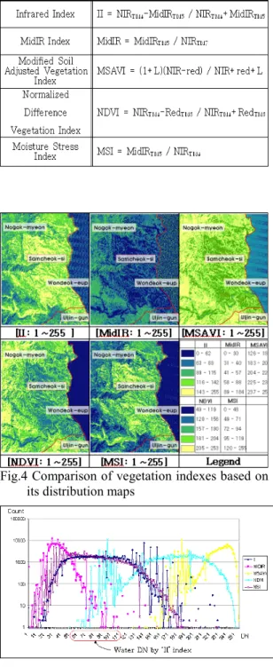
2. STUDY MATERIAL AND METHOD In order to compare the various vegetation index map, there area five index models, which are called as NDVI (Normalized Difference Vegetation Index), II (Infrared Index), MSI (Moisture Stress Index), MidIR (MidiR
2 Index), MSAVI (Modified Soil-Adjusted
Vegetation Index) by using Landsat ETM+(2000.
10. 16).
To verify the result of these, the forest fire damaged map was constructed through GIS DB processing like scanning, vectorizing, projection in order after field study.
For the geometric correction the RMS error was defined in 0.3 pixel (9m) and COST model was used for atmosphere correction. Nearest Neighbor method was used to resampling. Fig. 2 shows the entire study flow processing.
Fig. 2 Study flow chart
3. CONSTRUCTING FOREST FIRE DISATER MAP
3.1 Constructing GIS DB
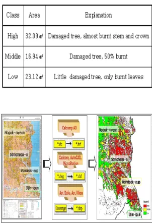
In order to classify and present forest fire damage level, high, middle and low GIS DB was first constructed through scanning, tracing, vectorizing in order. Table 1 shows the definition of forest fire damage level and Fig. 3 shows the result of GIS construction.
Table 1. Classification of forest fire damage level
Fig. 3 GIS DB construction in study area
3.2 Constructing vegetation index distribution map using Landsat ETM+ image
Vegetation index has mainly used to figure out the characteristic of vegetation in study area and vital index so that the distribution map of vegetation on earth could be constructed.
As shown in Table 2., there are five vegetation index algorithm such as NDVI (Normalized Difference Vegetation Index), II (Infrared Index), MSI (Moisture Stress Index), MidIR (MidiR Index), MSAVI (Modified Soil-Adjusted Vegetation Index) by using Landsat ETM+(2000.
10. 16).
Result of vegetation distribution characteristic has generally the similar DN value pattern between MSI and II and especially stream section of II has the most wide (62-112) while most of them have DN value of 30-141.
Each stream section of MidIR and MSAVI has more wide value distribution as show in Fig. 4, and Fig. 5 shows the characteristic of DN value distribution of each vegetation index.
Table 2. Vegetation indexes
3 Fig.4 Comparison of vegetation indexes based on
its distribution maps
Fig. 5 Characteristic of DN value distribution on each vegetation index.
3.2 Constructing forest fire disaster map using vegetation distribution map
As shown in Fig. 6, the forest fire disaster map was constructed considering forest damage three classes, high, middle and low.
Fig. 6 The forest fire disaster map
As the result of comparing the field study and each vegetation index, II has 32.37㎢, 26.16㎢
and 13.10㎢ mapping to high, middle, low, respectively and it is expected to have 26.84㎢
area difference comparing field study data. The rest of comparing result was figured out as shown Table 3.
Table 3. Comparison of area on each vegetation index of forest damage
[Unit :㎢]
6. CONCLUSIONS AND FURTHER STUDY
In this study, the GIS DB was first constructed based on forest fire damage area field trip and the vegetation vitality distribution maps were are constructed by using Landsat ETM+.
Also, the forest fire disaster damage map having its damage level was constructed after verifying the vegetation vitality distribution map and field study.
As the result, MSI and II are very sensitive to the ecology rate, moisture and moisture of soil and MidIR has the high correlation with moisture of soil. Also, there is possibility that MSAVI can be applied to various vegetation studies because this has wide DN values of forest section comparing other vegetation indexes.
In addition, MidIR is proved that it is not
4 proper vegetation index because it has difficulty
to figure between forest fire damage and none damage area also there is 36.53㎢ area difference from field study while MSI index is figured out as the most proper vegetation index having 5.97㎢
difference area from reference data also it has 8.13㎢ difference area form field study.
For the further works, there should be more proper spatial characteristic model or index to figure out forest fires, forest pest and landslide so that the detail and exact forest area damage should be verified. For this, the high resolution images such as IKONOS satellite images or KOMSAT MSC should be used.
REFRERANCE
Myung-Hee Jo, "The Application of Spatial Information Technology for The Forest Fire Information Management", The workshop on Forest Fire Monitoring, 2005.4.11, (KARI) Myung-Hee Jo, “Forest Fire Information System Using Spatial Technologies in Korea”, The Workshop on Initiatives for Detection and Control of Forest Fire, 2005.2.1, Hokkaido University.
Myung-Hee Jo, “The Application of Space Technology for Forest Fire Information System in Korea”, Asian WS on Satellite Technology Data Utilization for Disaster Monitoring, 2005.1.20, Kobe.
Budd,J,T,C.,and E.Jmilton, 1982, Remote sensing of salt marsh vegetation in the first four proposed Thematic Mapper, International Journal of Remote Sensing 3(2), pp.147-161
John R. jensen, 2000, Introductory digital image processing second edition, Prentice Hall.
Myung-Hee Jo, Myung-Bo Lee, Si-Young Lee, Yun-won Jo, Seong-Ryul Back., 2000, The Development of Forest Fire Forecasting System using Internet GIS and Satellite Remote Sensing Proceeding of the 21st ACRS, Vol.1, pp.1161-1166.
Myung-Hee Jo, Sung-Jae Kim, Kwang-jae Lee, 2003, The extraction ethod for the best vegetation distribution zone using satellite images in urban area, Proceedings of the 24th Asian Conference on Remote Sensing 2003, pp.181-183.
Myung-Hee Jo, Yun-Won Jo, Jeong-soo Oh, Myung-Bo Lee, Joon-Bum Kim, 2002, A Landscaped ecological approach for restoration of orest fire damaged area using satellite images and GIS, Korea long-term ecological research, Proceedings of An
International Symposium, 2002.6l pp.53.
Sung-Jae Kim, Joon-bum Kim, Myung-Hee Jo, Yong-Doo Lee, Ki-Dong Bu, 2004, Developing 3D forest stand allocation information management system to restore forest fire damaged area, Sam-chuk in Korea, Papers and Proceedings of the Geographic Information System Association, pp.53-56.
Sung-Jae Kim, Myung-Hee Jo, Joon-Bum Kim, Myung-Bo Lee, Joo-Hoon Lim, 2004, Implementation of the virtual reforestation system using spatial data, Proceedings of International Symposium on Remote Sensing 2004 & 20th Anniversary of the Korean Society of Remote Sensing, pp.77-80.
James E. Vogelmann. 1999. Effects of Landsat Thermatic Mapper radiometric and geometric calibrations on selected land cover analyses. Pecora 14 Proceeding.
pp143-153.
Jensen. 1996. Introductory digital image processing.
![Fig. 1 Study area [2000, Landsat ETM]](https://thumb-ap.123doks.com/thumbv2/123dokinfo/5197789.604915/1.892.461.765.672.934/fig-study-area-landsat-etm.webp)