This is an Open-Access article distributed under the terms of the Creative Commons Attribution Non-Commercial License (http://creativecommons.org/licenses/
by-nc/3.0) which permits unrestricted non-commercial use, distribution, and reproduction in any medium, provided the original work is properly cited.
*Eun Hyung Kim, Gachon University Professor of Landscape Architecture. [email protected]
A Study on a Conceptualization-oriented SDSS Model for Landscape Design
조경설계를 위한 공간개념화 지향의 공간의사결정지원시스템 모델에 대한 연구
Eun Hyung Kim
김은형*
요 약 본 논문은 조경설계를 위한 창의적 개념화를 지향하는 공간 의사 결정 시스템 모델에 대한 연구이다. (1)정보의 폭발 및 무시 (2)원칙성과 융통성의 딜레마 (3)비구조화된 성격의 계획 및 설계라는 세가지 특징 때문에, 현재 정보중심 의 GIS는 큰 역할을 못하고 있다. 이에 현재의 정보중심의 GIS에 대한 대안으로 공간 개념화를 지향하는 SDSS(공간의 사결정지원시스템)모델을 제시하고자 한다. 미래의 공간 개념화 지향의 SDSS는 인지적 관점을 기반으로 한 공간개념 화를 현재의 GIS기술과 연계시킴으로써 조경설계의 비구조적인 문제를 효율적이고, 창조적으로 해결할 수 있다. 공간 개념화 지향의 SDSS 모델은 (1)인간정보처리 (2)도구 및 이론의 상호작용 (3)인지과학 및 실천인식론 (4)의사결정지원 시스템 (5)인간과 컴퓨터의 상호작용 (6)창조적인 사고라는 핵심이론 및 기술을 반영한다. 향후 구현될 공간 개념화 지 향의 SDSS는 설계자가 공간계획 및 설계상에서 “숨겨진 조직”을 파악할 수 있게 하고, 생성 및 개념화 능력을 통해 새로 운 아이디어를 개발하고 이를 다른 설계자와 공유할 수 있게 한다. 공간개념화는 (1)버블다이어그램 지향의 설계지원 시스템 (2)어의적 기억의 확장으로서의 프로토타입 (3)삽화적 기억의 확장으로서 스크립트라는 세 가지 핵심 아이디어 를 통해 공간 설계의 개념화를 보다 용이하게 할 수 있다. 앞으로 이 세 가지 아이디어는 계획 및 설계를 위한 GIS기술의 미래 방향을 제시할 수 있을 것이다.
키워드 : 공간의사결정지원시스템, 버블 다이어그램, 프로토타입 정교화, 비구조화된 문제, 공간개념화, 인간정보처리 지오디자인
Abstract By combining the role of current GIS technology and design behaviors from the cognitive perspective, spatial conceptualization can be extended efficiently and creatively for ill-structured problems. This study elaborates the model of a conceptualization-oriented SDSS(Spatial Decision Support System) for a landscape design problem.
Current information-oriented GIS technology plays a minor role in planning and design. The three attributes in planning and design problems describe how the deficiencies of current GIS technology can be seen as a failure of the technology. These are summarized: (1) Information Explosion/Information Ignorance (2) Dilemma of Rigor and Relevance (3) Ill-structured Nature of planning and Design. In order to implement the conceptualization idea in the current GIS environment, it will be necessary to shift from traditional, information-oriented GISs to conceptualization- oriented SDSSs. The conceptualization-oriented SDSS model reflects the key elements of six important theories and techniques. The six useful theories and techniques are as follows; (1) Human Information Processing (2) Tool/Theory Interaction (3) The Sciences of the Artificial and Epistemology of Practice (4) Decision Support Systems (DSSs) (5) Human-Computer Interaction (HCI) (6) Creative Thinking. The future conceptualization-oriented SDSS can provide capabilities for planners and designers to figure out some “hidden organizations” in spatial planning and design, and develop new ideas through its conceptualization capability. The facilitation of conceptualization has been demonstrated by presenting three key ideas for the framework of the SDSS model: (1) bubble-oriented design support system (2) prototypes as an extension of semantic memory, and (3) scripts as an extension of episodic memory in a cognitive pschology perspective. The three ideas can provide a direction for the future GIS technology in planning and design.
Keywords :SDSS, Bubble Diagram, Prototype Refinement, Ill-structured problem, Spatial Conceptualization, Human Information Processing, Geodesign
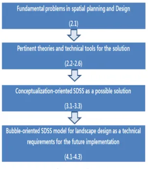
Figure 1. Structure of this study
1. Introduction
While current information-oriented GIS technology plays a minor role in planning and design, the model of a conceptualization-oriented SDSS (Spatial Decision Support System) can optimize the use of current GIS technology for solving ill-structured problems.
This study elaborates the model of a conceptualiza- tion-oriented SDSS for the future landscape design, and develops requirements for the tools that can extend the spatial conceptualization in the SDSS environment.
In this study, direct implementation of the SDSS is not the purpose to adapt to currently available computer technologies but rather to provide a direction for the future implementation of spatial decision support sys- tems in planning and design environments. The even- tual goal of this study is to provide planners and de- signers with a tool for efficiency and creativity. In the SDSS environment, human is an independent variable and machine is a dependent variable. To optimize effi- ciency and creativity, human values and wisdom must be harmonized with information and knowledge pro- vided by the SDSS.
Chapter 2 describes the following: while current in- formation-oriented GIS technology has been a good tool for structured problems, it has not been a suppor-
tive device for ill-structured problems. To solve this problem, theories and techniques are reviewed.
In chapter 3, a conceptualization-oriented SDSS is introduced as a method to solve the problems described in the chapter 2.
In chapter 4, a bubble-oriented SDSS is developed for the application of the method developed in Chapter 3. It demonstrates that a conceptualization-oriented SDSS can facilitate landscape design problems better than ex- isting GIS technologies.
2. Theoretical Review
This chapter tries to figure out fundamental problems in planning and design in terms of GIS application and introduce theories and techniques to solve the problems
2.1 Three Fundamental Attributes in Planning and Design
Human “cognitive limits(seven chunks plus, minus two)”[16] are assumed to be the main source from which the three attributes emanate: (1) “Information Explosion/Information Ignorance,” (2) “Dilemma of Rigor and Relevance,” and (3) “Ill- structured Problems.”
The three attributes in planning and design problems describe how the deficiencies of current GIS technol- ogy can be seen as a failure in GIS environment.
(1) GIS products have the capacity to generated in- formation explosively but most of it is ignored because it exceeds human cognitive capacity. (2) “Dilemma of Rigor and Relevance” occurs because both technological knowledge and artful intuitions are required to solve planning and design problems[21]. (3) Most important Planning and Information-oriented GIS products have proven successful with routine problems but have diffi- culty with those that are ill- structured[11]. These three attributes deal with the problem of human cognitive limits. Therefore, it is essential to confront these funda- mental attributes and recognize the need for an effec- tive conceptualization aid.
2.2 Human Information Processing
Since human cognitive capacity can not be extended by itself, it is essential to take advantage of tools that
can extend human conceptualization power. This study are some strategies for extension of human cognitive capacity based on cognitive psychology. The human memory is divided into three parts; sensory, short-term, and long-term memory[1]. Among the three memories, the short-term memory, as a working memory, processes given information and then transfers it to long-term memory. Because of the limited information processing capacity of the short-term memory, “complexity” may become a problem, and limit human comprehension.
While short-term memory is working memory uti- lized in conceptualization, long-term memory is a base for information and knowledge.
Episodic memory refers to a person’s “autobiographical memory, to the personally experienced and remembered events of a lifetime.” These memories are part of your personal history and are not generally shared by others.
Semantic memory refers to a person’s general world knowledge, including vocabulary and rules of lan- guage, and the general knowledge that relates concepts and ideas to one another.
2.3 Tool/Theory Interaction
Edward Hall, an anthropologist, explains man has been able to improve or specialize various functions by developing his extensions. The computer is an ex- tension of the brain, the telephone extends the voice, the wheel extends the legs and feet[7]. The main point of the tool/theory interaction theory is that there are many “organized” complexity problems that wait for proper tools to organize the complexity. By identifying the “hidden organizations” in the complex problems, the nature of the problems can get less “wicked.”[22]
Because humans have cognitive limits in perceiving data, there is a need to reshape current GIS technology to function as a tool for thinking. Perception depends not on the actual data available to us but rather on how we represent it.
2.4 Decision Support Systems (DSSs)
The main issue in DSS is how to cope with un- anticipated variability and avoid brittleness in a com- plex, ill-defined problem solving task. The solution is
“conceptualize the decision situation”. The function of
human “concept” permits both generalization (deduction) and induction of rules of category membership[1].
Therefore, conceptualization is a cognitively merging area of deduction and induction.
DSS can help users to improve their conceptualiza- tion power through: (1) Enhancing the ability to experi- ment with several possible worlds or possible strategies (2) Enhancing the ability to visualize or make concrete, in order to better see the implications of user concepts (3) Enhancing error tolerance by providing feedback about the result of actions[19].
2.5 Human-computer interaction (HCI) The discipline of HCI consists of two main sub- disciplines. The first, software engineering primarily concerns the computer side of interaction. The second, ergonomics primarily concerns the human side of the interaction[13].
The purpose of the two main sub-disciplines of HCI, software engineering and ergonomics, is to optimize human-computer interaction.
This study is focused only on the human side of the interaction. Because ergonomics is more important for adaptive problem solving of ill-structured problems.
Therefore HCI will be described in the context of how a designer as an ill- structured problem solver can opti- mize his/her conceptualization.
2.6 Creative Thinking
In landscape design, because it is not a generalized routine problem, design ideas can usually be presented by the prototypes of certain design situations.
Design is classified as follows: (1) prototype refine- ment (2) prototype adaptation and (3) prototype creation.
(1) Prototype refinement; design activity involves working within the constraints of a particular class of designs. This also involves selecting from sets of can- didate design decisions and adjusting parameters[4].
(2) Prototype adaptation; activity involves extending the boundaries of a particular class of designs. That is adjusting the concepts that define the space of designs.
(3) Prototype creation; activity is where totally new prototypes emerge.
Most design situations seem to fall within the model of prototype refinement or adaptation. Using a proto- type may be the most efficient way of acquiring the proper knowledge. The structure and procedure of pro- totype design can often provide a useful analogy for a new site. Also, the prototype is also a good evalua- tion tool for the new design because previous solutions should have been empirically tested and proven to be successful.
In conclusion, because of the problem of human cog- nitive limits, there have been no tools to overcome cog- nitive limits. Even if powerful computer technologies can improve information-oriented GIS products, plan- ners and designers will still be constrained. Therefore, it is essential to confront these fundamental attributes and recognize the need for an effective conceptualiza- tion aid. While computer information processing pro- vides the basis for information-oriented GIS technology, human information processing is a crucial part of the total problem solving process called planning and design. If conceptualization can be extended by the new tool, conceptualization-oriented SDSSs, problem solving in planning and design can be improved.
3. A Conceptualization-oriented SDSS Model
This chapter presents the model of a conceptualiza- tion- oriented SDSS intended to address ill-structured planning and design problems in GIS environments.
In order to implement the conceptualization idea in the current GIS environment, it will be necessary to shift from traditional, information-oriented GISs to con- ceptualization-oriented SDSSs. This model will be ap- plied to a landscape design problem in chapter 4 as a method.
3.1 Current Use of GIS technology in Landscape Design
A dear distinction between traditional GIS technol- ogy and conceptualization-oriented SDSSs is that while GISs are a general-purpose tool to automate routine problems, the SDSS deals with the fundamental ill- structuredness of the entire planning and design proc-
ess and includes more than GIS functions for specific problems such as a residential landscape design.
A “factor-oriented GIS”[15] is sum of the factor maps that reflect a certain aspect of reality. In a factor- oriented GIS environment, quantitative and inductive approaches have been useful for less subjective and straightforward applications such as resource management and other quantifiable tasks. In addition to these ap- proaches in current GIS products, landscape design in- cludes uniqueness and qualitative characteristics that cannot be easily included in the sum of quantified factors. The role of current GIS technology in the de- sign process involves only providing accurate and easi- ly recognizable information and images.
3.2 Conceptualization-oriented SDSS A conceptualization-oriented SDSS can provide ca- pabilities for planners and designers to figure out some
“hidden organizations” in land use planning and design, and generate and develop new ideas through its con- ceptualization capability.
The SDSS has the following characteristics:
(1) Its focus is not on computer information process- ing but on “Human Information Processing[12].” It does not mean that both are exclusive. It includes the both.
(2) The role of current information extricated GIS technology as an information presentation tool is ex- tended by the SDSS to include visual thinking capa- bilities such as “linked views” and “multiple representa- tions.”[17] This extension is based on “Tool/Theory Interaction” described earlier.
(3) It has the embedded design process. When a user is demanded for problem solving, the needed knowl- edge can be promptly provided in the SDSS.
(4) It can facilitate adaptation to ill-structured prob- lems as well as routine and administrative ones.
In summary, a conceptualization-oriented SDSS is an extension of information-oriented GIS technology to attack ill-structured problems. The SDSS can be generally established by combining some useful func- tions in current GIS technology with other required as- pects that are unique in a design problem(Table 1).
Table 1. From Information-oriented GISs toward a conceptualization-oriented SDSS
Information-Oriented
GISs ▶ Conceptualization-oriented SDSSs Computer Information
Processing
Human Information Processing Presentation Tool Conceptualization Tool Explicit Knowledge-driven
GISs
Implicit knowledge-driven SDSSs
Routine and Administrative Problems
Nom-routine and Ill-structured Problems Quantitative Analysis Integration of Qualitative
Analysis Limited User Interface
(Single View) Linked views interface General-purpose GISs Relational SDSSs Convergent Thinking Tool Divergent Thinking Tool
Black Box system Contest-oriented and interactive System Dependency on GIS
Technical Intermediaries Independent SDSS Partial Accomplishment Total Accomplishment
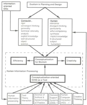
Figure 2. Morphology of a Conceptualization-oriented SDSS
3.3 Six useful ideas for developing the conceptualization-oriented SDSS Model The conceptualization-oriented SDSS will be pre- sented as a model that reflects the key elements of six important theories and techniques reviewed in the previous chapter: “Human Information Processing,”
“Tool/Theory Interaction,” “The Sciences of the Artificial and Epistemology of Practice,” “Decision Support Systems (DSSs)[18],” “Human-Computer Interaction (HCI),” and “Creative Thinking[4].”
The Figure 2 shows that six theories and techniques are combined into the model of the SDSS for the better application of current information-oriented GIS tech- nology in planning and design.
Information-oriented GIS technology supports only one side of the dualism. Because of all these difficulties, the dualism of “rigor” and “relevance”[12] seems ever- present in planning and design. The dualistic problem can be represented as the dilemma between technical rationality and artful competency when they cannot be combined. These two aspects of planning and design have rarely been harmoniously combined for pro-
fessional practice. Most planners and designers seem to be biased to either one of the two poles: rigorous science and relevant practice.
Conceptualization is a key to integrate the dualistic characteristics of planning and design.
4. A Bubble-oriented SDSS Model for Landscape Design
This chapter elaborates a bubble-oriented SDSS model as an application of a conceptualization-oriented SDSS model for a residential site design. For the oper- ation of the SDSS elements, important SDSS functions are described to approach the landscape design problem.
Because of the iterative nature of design, the role of GIS technology does not have to end in the design process. Abstract design still requires proper spatial in- formation for the idea development.
For example, it is important for the designer to know specific information about a particular design area that may be in a bubble. By combining the GIS capability for spatial data exploration and abstract design process, designers can speed up their design process: the im- proved responsiveness in exploratory capability may
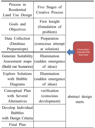
Table 2. A landscape design process with information- oriented GISs
Process in Residential Land Use Design
Five Stages of Creative Process
Goals and Objectives
First Insight (fomulation of
problem) Data Collection
(Database Preparatiopn)
Preparation (conscious attempt
at solution) Generate Suitability
Assessment maps (Build out Scenarios)
Illumination (sudden emergence
of ideas) Explore Solutions
with Bubble Diagrams
Illumination (sudden emergence
of ideas)
abstract design starts Conceptual Plan
with Several Alternatives
verification (conscious development) Develop Individual
Bubbles with Design Criteria
Final Plan
lead designers to a more creative virtual world.
Here, information-oriented GIS technology is effec- tively extended into the design process toward a con- ceptualization-oriented SDSS. In Table 2, the unilateral capability of current GIS products can be specifically explained. The use of current GIS products in land- scape design stops at generating suitability assessment maps after overlaying perhaps three or four maps. It is helpful to generate several suitability scenarios to determine priorities for the final recommendation but the results are often less persuasive than the efforts made in the generation of composite maps. This is due to the fact that the results from GIS technology cannot effectively include a client’s qualitative criteria and ex- periential knowledge of the design site.
Because of the iterative nature of design, the role of GIS technology does not have to end in the design process. Abstract design still requires proper spatial in- formation for the idea development. For example, it is important for the designer to know specific in- formation about a particular design area that may be
in a bubble. By combining the GIS capability for spatial data exploration and abstract design process, designers can speed up their design process: the improved re- sponsiveness in exploratory capability may lead design- ers to a more creative virtual world. Here, information- oriented GIS technology is effectively extended into the design process toward a conceptualization-oriented SDSS.
4.1 Structure of a conceptualization-oriented SDSS Model for landscape design
As mentioned, one fundamental attribute in planning and design is its ill-structured nature. Designers must adapt to new design problems with uncertainty. They cannot have one complete solution procedure that is applicable to all design problems. Based on their expe- rience and skill, problems can be structured.
In the design process, there are three fundamental design elements to complete an entire design: 1) “proper (or general) knowledge,” 2) “rational (or personal) de- sign process,” and 3) “conceptualization of the knowl- edge and process” for adaptive solution development.
In human information processing, the sources of proper knowledge are semantic memories, the sources of the rational design process are episodic memories that are not generally shared by others, and conceptualization of the knowledge and process described above happens in the short-term memory. Extension of human memo- ries is a key for conceptualizing ill-structured problems in planning and design.
As seen in Figure 3 below, the “proper knowledge”
can be gained from design prototypes as an extension of semantic memory. The “rational and personal design process” can be represented by scripts as an extension of episodic memory. Long-term memories, semantic and episodic, provide short-term memory with general knowledge and a personal design process to be conceptualized. Interactions between the memories are established in the SDSS for a total accomplishment of a design task.
In conclusion, bubble diagrams are a conceptualized spatial expression of spatial information, prototypes and scripts in short-term memory. Creative ideas are conceptualized in the short-term memory with the help of long term memories.
Figure 3. Structure of a Conceptualization-oriented SDSS Model for Landscape Design[10]
Figure 4. Bubble-oriented SDSS Model in Landscape Design[10]
Figure 5. Different levels of cognitive depth for the conceptual bubbles
4.2 Three Key Ideas for the SDSS Structure By extending the processing capability of the proper knowledge and the rational process simultaneously, conceptualization can be more effectively conducted.
The SDSS can be implemented by three key Ideas:
(1) “Bubble-oriented Design Support System,” (2)
“Prototype as an Extension of Semantic Memory,” and (3) “Script as an Extension of Episodic Memory”. These ideas provide a framework of the SDSS for a landscape design.
4.2.1 Bubble-oriented SDSS Model in Landscape Design
From a cognition-saving perspective, the bubbles are the areas where the designer’s limited cognitive ca- pacity must concentrate. The remaining blank area is shallow in design thinking because the area can be used mostly in the master plan stage for mechanically and aesthetically connecting the designs in the bubbles. The limited capacity of the short-term memory charac- terized as “seven chunks plus, minus two,” is an im- portant factor to be considered here because only some seven items(bubbles) can be held in the fast, short-term memory. By compressing the process of design think- ing into a single unit, the cognitive limitation in ill- structured design problems can be overcome.
This bubble-oriented design support system is more responsive to a top- down approach because it can be applied to complicated spatial design problems which require GIS technology. It should be noted that the areas covered by the design modules can be considered as cognitive bubbles, as opposed to drawn bubbles in a top-down approach, and it is still possible for the SDSS to provide spatial information and knowledge as a design is developed for specific problems.
Particular capability can be achieved by the SDSS functions, “Linked Views” and “Multiple Representa- tions” later[2].
The Figure 4 below shows that the bubbles in the residential design example indicate several layers of design thinking and information processing.
The Figure 5 shows they are cognitively deeper than
Table 3. A script for the landscape design[10]
Headers Design Behavior
Goals and Objectivesdivergent thinking idea generation for a vision
Information Collection and Analysis
information collection information analysis (information query and
analysis maps) Suitability
Assessment
what-if questions (build out scenario) tracing-paper overlay
suitability maps Conceptual Design draw bubble diagrams look for
big ideas
Conceptual Plan
convergent thinking study prototypes idea development generate alternatives test the alternatives in an overall context
Individual Bubbles
more technical questions more prototypes in detail mere design criteria relate other bubbles for an
overall design
Master Plan
collect individual designs from the bubbles connect the designs
with circulation and planting other blank areas in terms of the levels of abstraction
represented.
4.2.2 Prototype as an Extension of Semantic Memory As discussed in 2.6 Creative Thinking, the majority of spatial designs are adaptations of solutions pre- viously used. Proven models to be emulated become prototypes. In a design environment, general world knowledge includes graphic symbols, design rules, and prototype designs. Alexander’s “pattern language[6]”
is analogous to the linguistic language in the semantic memory. Each pattern describes a problem that occurs over and over again in our environment, and then de- scribes the core of the solution to that problem, in such a way that you can use this solution, without ever do- ing it the same way twice. The idea of using the pat- terns as atoms of conceptual structure becomes more significant for computerization of the design process.
This idea can be also applied to the landscape design process. Such ideas have been accumulated in the land- scape design, and these become prototype designs.
4.2.3 Script as an Extension of Episodic Memory A major advantage of bringing the design process into the open is that others can participate and contrib- ute information and insights that are outside the realm of the designer’s knowledge and experience[9]. This is significant for computerization of design because current computer technology is good at explicit and procedural tasks. If extraordinary things can exist on the background of ordinary ones, the design process must be rational and explicit to generate extraordinary and creative designs.
Designers develop a preference for a particular way of structuring their process of design and hold strong attitudes about appropriate procedure[14]. A personal design process can be externalized to some extent in the SDSS as a script. Because a script also contains general information about a particular setting, the script consists of several headers that either name the script or refer to some semantically related concept that is a part of the script. In the landscape design, the headers can be named as follows: Goals and Objective, Informa- tion Collection and Analysis, Suitability Assessment, Conceptual Design, Conceptual Plan, Module Design,
Master Plan. Each designer can have their own scripts as “design precedents[5]” in the SDSS.
In the Table 3, design behaviors are good examples of the script. Human knowledge of the real world is organized in bundles of related information they define as scripts[20]. As a script contains general information about a particular setting, phrases or words that activate a script are called “headers”, which either name the script or refer to some semantically related concept that is a part of the script. In a general sense, a header is nothing more than a prime, a concept that activates a related body of knowledge. A script is also activated by the whole set of “frames” (also called “slots”), which are details of a header and describes specific events within the script. The examples are “drawing bubble diagrams” as a more specific level of Conceptual Design, and “developing designs of cluster housing” as the one of Modular Design. This prepares the designer to re- ceive specific information, design rules and knowledge about those frames. When a design prototype is ex- tracted from the prototype library, it must be modified in each designer’s script for further development. This script should be able to reflect each designer’s style
Table 4. SDSS Functions for the Landscape Design[10]
SDSS Functions Operation
Linked Views
The capability for a designer to maneuver from one level of
abstraction to another Multiple
Representations
The capability of exposing hidden dimensions
Spatial Analysis Function
The capability of identifing suitable areas by extracting unsuitable areas for development
from each spatial information category
Drawing Function for graphic ideation and communication
Externalizing a designer’s thinking by drawing
Direct Manipulation
Methods for computer interface as a collection of objects that are directly analogous to object in the
real world Evaluation
Functions to Test Feasibility of Ideas
A Design’s comparison of his/her working design with other levels
of designs in a design process
Idea Log
Maintaining Idea log can be a significant cue for other Design
problems Measurement
Function for Area Measurement the actual facilities Color and Texture Excitement and clarity to
idea-sketching Copy, Cut and Paste Manipulation prototypes
Snapshot Function Effective way to show the source of the design idea to others Scale Manipulation
Function
Reduction or enlargement of the object to a certain scale and particular design process for the residential design.
The script is one particular designer’s precedence that can be applied to other design situation. By having the two cognitive extension tools, prototypes and scripts, the SDSS can extend the designer’s semantic and epi- sodic memory limitation. This capability is important because while the designer has to find proper in- formation and knowledge, his/her intuitive thinking process can be disconnected with his/her attention ori- ented to other directions, and the original idea might be buried again under his/her sub-conscious memory level. In this way, the designer’s cognitive load can be reduced and his/her attention can stays on a more intuitive thinking process that can lead more creative products.
4.3 Important SDSS Functions for the Residential Design
The role of information-oriented GIS technology for the design problem is extended throughout the entire design process by SDSS functions such as “linked views” and “multiple representations.” This novel ap- proach is expected to facilitate efficiency and creativity in planning and design and can motivate the future di- rection of current GIS technology in land use planning and design.
An adaptive approach to ill-structured problems is essential in the design environment, most commands or functions should be provided as instruments. In ad- dition, flexibility is the key to organizing the functional aspects of the SDSS. Flexibility can create incon- sistency in understanding of the system but provide a more creative way of using the system for the user.
Important SDSS functions are described for the oper- ation of the SDSS elements; (1) Linked Views (2) Multiple Representations (3) Spatial Analysis Function (4) Drawing Function for graphic ideation and commu- nication (5) Direct Manipulation (6) Evaluation Functions to Test Feasibility of Ideas (7) Idea Log (8) Measurement Function for Area (9) Color and Texture (10) Copy, Cut and Paste (11) Snapshot Function (12) Scale Manipulation Function.
The main features of SDSS Functions are described in the following Table 4.
5. Conclusion
The model of a conceptualization-oriented SDSS has been elaborated for a landscapel design problem in this study. As described earlier, dualism of planning and design becomes integrated through conceptualization.
By embedding this conceptualization power throughout planning and design process, a total accomplishment of problem solving can be made in the SDSS environ- ment while current GIS technology can support plan- ning and design only partially.
Based on the limited processing capability of “seven
plus, minus two” items for a short-term memory, the bubble-oriented design system is discussed. The three ideas, “Bubble-oriented Design Support System,”
“Prototype as an Extension of Semantic Memory,” and
“Script as an Extension of Episodic Memory,” can fa- cilitate extending a designer’s short- and long-term memories toward a total accomplishment of a design task. These ideas provide a framework of the SDSS for the residential design.
Hopefully, the idea can provide a direction for the future application of GIS technology in landscape design. By combining the role of current GIS technol- ogy and design behaviors from the cognitive perspective, spatial conceptualization can be extended efficiently and creatively for ill-structured problems.
It is argued that a conceptualization-oriented SDSS model is a “contingency framework” for the adaptive problem solving. And this study has demonstrated the possibility of opening a new “technological oppor- tunity”[8] in planning and design. The recent emer- gence of geodesign[23,3] technologies can drive the opportunity into reality and more researches need to be done.
References
[1] Ashcraft, M. H. 1989, Human Memory and Cognition, Scott, Foresman and Company.
[2] Batey, P. W. J; Breheny, M. J. 1978, Methods in Planning. Part II: a Prescriptive' Review, Town Planning Review, 49:502-517.
[3] Carl S. 2012, A Framework for Geodesign:
Changing Geography by Design, Journal of Landscape Architecture, July 2, pp. 87.
[4] Coyne, R. D. et al. 1990, Knowledge-Based Design Systems, Addison-Wesley Publishing Company.
[5] Coyne, R. D; Yokozawa, M. 1992, Computer Assistance in Designing from Precedent, Environ- mental and Planning B: Planning and Design, 19:143-171.
[6] Galle, P. 1991, Alexander Patterns for Design Computing: Atoms of Conceptual Structure, Environ- mental and Planning B: Planning and Design, 18:
327-346.
[7] Hall, E. T. 1966, The Hidden Dimension, New
York: Doubleday & Company.
[8] Harris, B. 1988a, The Emerging Unity of Science and Humanism in Planning, Journal of American Planning Association. Autumn, pp. 521-524.
[9] Jones, C. J. 1970, Design Method: Seeds of Human Futures, Wiley-lnterscience.
[10] Kim, E. H. 1993, From Information- oriented Geographic information Systems Toward Conceptualization-oriented Spatial Decision Support Systems in Planning and Design, Ph.D.
Dissertation, University of Massachusetts.
[11] Langendorf, R. 1985, Computer and Decision Making, Journal of the American Planning Association, 51(4):422-33.
[12] Lindsay, P. H; Norman, D. A. 1977, Human Information Processing, Academic Press: New York, Sanfrancisco, London.
[13] Long, J. 1989, Cognitive Ergonomics and Human Computer Interaction: an Introduction, In Long, J; Whitefield, A. (Eds), Cognitive Ergonomics and Human Computer Interaction. New York:
Cambridge University Express.
[14] Lynch, K; Hack, G. 1984, Site Planning, The MIT Press.
[15] MacDougall, E. B. 1975, The Accuracy of Map Overlays, Landscape Planning, 2:23-30.
[16] Miller, G. A. 1956, “The Magical Number Seven, Plus or Minus Two: Some Limits on Our Capacity for Processing Information”, PSYCHOLOGICAL REVIEW, 63(2):81-97.
[17] Mannheim, K. 1949, Man and Society: in an Aoe of Reconstruction, New York: Harcourt.
[18] Rasmussen, J. 1988, Decision Support Systems- Designing to Extend the Cognitive Limits, Handbook of Human-Computer Interaction edited by Helander, M., Elsevier Science Publishers B.V., pp. 997-1030.
[19] Rich, E; Knight, K. 1991, Artificial Intelligence, Mcgraw-Hill, Inc.
[20] Schank, R. C; Abelson, R. P. 1977, Scripts, Plans.
Goals and Understanding, Hillsdale, NJ: Erlbaum.
[21] Schön, D. A. 1983, The Reflective Practitioner, New York: Basic Books.
[22] Weaver, W. 1967, an Essay on Science and Com- plexity, Science and Imagination, Basic Books,
Inc.
[23] William, R. M. 2012, Introducing Geodesign:
The Concept, Esri. <http://www.esri.com/library/
whitepapers/pdfs/introducing-geodesign.pdf>
Received:2014.10.31 Revised :2014.12.22 Accepted:2014.12.29
![Figure 3. Structure of a Conceptualization-oriented SDSS Model for Landscape Design[10]](https://thumb-ap.123doks.com/thumbv2/123dokinfo/5119575.333068/7.799.82.383.100.375/figure-structure-conceptualization-oriented-sdss-model-landscape-design.webp)
![Table 3. A script for the landscape design[10]](https://thumb-ap.123doks.com/thumbv2/123dokinfo/5119575.333068/8.799.412.722.120.523/table-a-script-for-the-landscape-design.webp)
![Table 4. SDSS Functions for the Landscape Design[10]](https://thumb-ap.123doks.com/thumbv2/123dokinfo/5119575.333068/9.799.415.722.124.754/table-sdss-functions-for-the-landscape-design.webp)
