29(12); 1185~1198; December 2020 https://doi.org/10.5322/JESI.2020.29.12.1185
ORIGINAL ARTICLE
국립공원의 합리적 공간관리를 위한 비오톱 유형화 및 평가 연구
염정헌․한봉호1)*
강릉원주대학교 환경조경학과,
1)서울시립대학교 조경학과
Biotope Classification and Evaluation for Rational Spatial-management of National Park
Jung-Hun Yeum, Bong-Ho Han1)*
Department of Environmental Landscape Architecture, Gangneung-Wonju National University, Gangneung 25457, Korea
1)
Department of Landscape Architecture, University of Seoul, Seoul 02504, Korea
Abstract
This study aimed to suggest a framework for biotope classification and evaluation based on habitat values to rationally establish management areas of national parks. The factors and indicators related to the biotope classification and evaluation were established based on integration from those of previous studies. The decision tree evaluation process was applied to the classification and evaluation of the biotope type level. The evaluation of the biotope group level was carried out to determine the weight and the AUEM (Adding Up Estimation Matrix) was applied for the final grades. As a result, the biotope type of Seolaksan National Park was classified into 43 types and Odaesan National Park was classified into 41 types. Bukhansan National Park, which is located in a metropolitan city, was classified into 49 types. In terms of biotope evaluation, grade Ⅲ had a ratio of 50.6%, the highest in Seolaksan national park. The ratios of grade I and grade II, which have great ecological-value, were respectively 12.0% and 36.5%. Grade II was 48.2%, the highest ratio in Odaesan National Park. The ratios of grades I and II were 10.8% and 37.9%, respectively. Grade III was 54.8%, the highest ratio in Bukhansan national park, and the ratios of grade I and grade II, which have great ecological-value were, respectively, 11.4% and 25.7%. The biotope values of major national parks were evaluated according to the type focusing on the actual vegetation. This framework can be considered for application to the spatial management of other types of protected areas.
Key words : Habitat value, Spatial managing, Actual vegetation, Protected areas
1)
1. 서 론급격한 도시개발에 따른 도시환경 개선 및 친환경적
도시관리의 중요성은 그 어느 때보다 중요한 시기이다.
특히, 도시공간에 대한 생태적 가치 보전과 인간의 이용 갈등이 빈번한 사회적 구조속에서 자연생태적 가치를
Received 15 July, 2020; Revised 23 November, 2020;
Accepted 23 November, 2020
*
Corresponding author: Bong-Ho Han, Department of Landscape Architecture, University of Seoul, Seoul 02504, Korea
Phone : +82-2-6490-2844 E-mail : [email protected]
ⓒ The Korean Environmental Sciences Society. All rights reserved.
This is an Open-Access article distributed under the terms of the Creative Commons Attribution Non-Commercial License (http://
creativecommons.org/licenses/by-nc/3.0) which permits unrestricted non-commercial use, distribution, and reproduction in any medium, provided the original work is properly cited.
본 논문은 2015년도 서울시립대학교의 박사 학위논문의 일부입니다.
객관적으로 유형화하고, 평가할 수 있는 비오톱 지도에 대한 사회적 필요성이 대두되었으며, 자연환경보전법상 에서 시단위 이상의 지자체는 ‘도시생태현황지도’를 작 성하도록 하였다. 공간적 경계를 갖는 특정 생물군집의 서식 공간(Sukopp and Weiler, 1988)으로 정의되는 비 오톱(biotope)은 도시의 과밀화와 팽창화에 따른 자연생 태계의 원리에 기반한 생태적 측면과 인간행태적 측면이 포함된 경관생태적으로 해석 되며(Ra, 1997) 도시 환경 관리에 중요한 도구로서 활용되고 있다. 이와 더불어, 생 태적 가치를 객관화하여 공간단위에 반영할 수 있다는 특성을 반영하여 비오톱 맵핑(mapping) 기반의 보호지 역 관리 필요성도 지속적으로 제기되고 있다(Qiu et al., 2010; Schiele et al., 2015). 우리나라 국립공원은 생물 다양성이 우수한 보호지역 유형으로서 보전 중심의 현명 한 이용을 추구하는 지역이다. 하지만, 생태계 가치에 기 반 하지 않은 단순 지형에 의한 용도지구 설정 문제(Yim et al., 1987; Jo et al, 1997) 등 공간 관리에 있어서의 생 태적 가치 반영의 필요성이 지속적으로 요구되고 있다.
기존의 국내 비오톱 관련 주요 연구는 독일의 비오톱 유 형분류에 대한 사례 연구(Choi and Lee, 2007)를 시작 으로 하여, 비오톱의 표준안 마련을 위한 유형 분류 및 방 법을 체계화(Choi et al., 2009; Choi, 2010; Kim and Oh, 2013)하고, 기 구축된 도시별 도시생태현황지도를 활용하여 도시 비오톱의 특성을 분석(Kim et al., 2015) 하는 등 비오톱 분류 및 평가체계 틀 구축을 위한 연구가 주류를 이루고 있다. 또한, 비오톱 유형의 객관화 제고를 위한 식물군집 특성 활용연구(Kim et al., 2015), 도시숲 과 야생조류 서식처 관리를 위한 비오톱 활용연구(Oh et al., 2008; Noh et al., 2013)가 진행 되었고, 비오톱 기반 의 경관평가, 자연체험 및 휴양가치 모형 개발(Cho et al., 2010; Park et al., 2012), 도시관리 차원에서 구도심 지역의 용도지역별 비오톱 유형 평가 방법론(Park and Han, 2015) 등의 연구도 수행되었다. 하지만, 대부분의 연구는 도시지역을 대상으로 이루어졌으며, 생물다양성 이 우수한 보호지역을 대상으로 하여 수행된 연구는 미 흡하였다.
따라서, 본 연구는 우리나라의 대표적 보호지역 유형 인 국립공원을 대상으로 하여, 생태적 가치를 반영한 비 오톱 지도의 유형분류 및 평가 방법을 제시함으로써 향 후, 공원관리 정책의 기초자료를 제공하고자 하였다.
2. 연구방법
2.1. 연구대상지
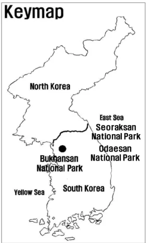
연구대상지는 IUCN Category Ⅱ 유형으로, 생물다 양성 및 경관가치가 우수한 설악산국립공원(1970년 지 정), 오대산국립공원(1975년 지정)과 대표적 도시근교형 국립공원인 북한산국립공원(1983년 지정)을 대상으로 하였다. 지정면적은 설악산국립공원 398.2 ㎢, 오대산국 립공원 326.3 ㎢, 북한산국립공원 76.9 ㎢ 등이며, 용도 지구상 보전성격이 강한 공원자연보존지구의 면적은 설 악산국립공원이 전체면적의 84.3%, 오대산국립공원이 49.8%, 북한산국립공원이 38.4% 등이었다. 특히, 북한 산국립공원의 경우, 연 탐방인원이 5,574,539명(‘19년 기준)으로 이용압력이 매우 높은 국립공원이다(www.
knps.or.kr, 2020)(Fig. 1).
Seoraksan National Park
Odaesan National Park
Fig. 1. The location map of the survey sites.
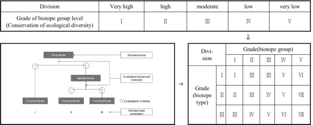
Division Very high high moderate low very low Grade of biotope group level
(Conservation of ecological diversity) Ⅰ Ⅱ Ⅲ Ⅳ Ⅴ
⇓
⇒
Divi- sion
Grade(biotope group)
Ⅰ Ⅱ Ⅲ Ⅳ Ⅴ
Grade (biotope
type)
Ⅰ Ⅰ Ⅲ Ⅲ Ⅴ Ⅵ
Ⅱ Ⅱ Ⅲ Ⅳ Ⅴ Ⅶ
Ⅲ Ⅲ Ⅳ Ⅴ Ⅵ Ⅶ
Fig. 2. Classification and evaluation system of biotope.
2.2. 조사분석방법
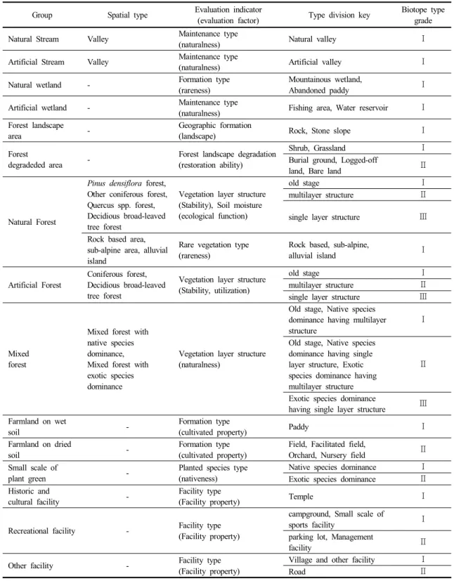
비오톱 조사는 1/5,000수치지형도에 정사영상자료와 임상도로 1차 토지이용 및 침엽수, 활엽수 경계를 구분하 고, 현장 조사하여 구축된 자료를 기반으로 하여 비오톱 유형화 및 평가를 진행하였다. 비오톱 조사결과는 ArcGIS 10.1을 활용하여 맵핑하였다. 소분류 유형화 및 평가는 의사결정나무방법(Choi, 2009)을 적용하였으며, 중분류 가중치는 중분류 유형에서의 가치를 보정하는 개 념으로써 비오톱 유형 평가 목표인 생물종 및 서식처 보 존 가치 범위를 5개 등급으로 구분하였다. 최종 비오톱 유형 평가는 합산평가매트릭스 방법을 사용하였으며, 소 분류 유형과 중분류 유형 가중치를 종합하여 총 7단계의 가치 등급으로 구분하였다(Fig. 2).
비오톱 유형 및 평가를 위한 지표(항목)는 선행 연구 (Table 1)에서 제시된 내용을 종합하여 설정하였다. 하 천은 정비유형을 지표로 중분류하였고, 소분류는 중분류 유형을 유지하였다. 습지는 정비유형으로 중분류 하였고, 생성유형과 조성유형을 통해 소분류 하였다. 산림은 산 림경관유형과 산림식생생성유형에 따라 중분류하였고, 산림경관유형은 지형생성과 산림경관훼손, 산림식생생 성유형은 식생층위구조와 토양습도조건, 희귀식생유형 등으로 각각 소분류 하였다. 조성녹지는 녹지규모에 따 라 중분류하였고, 식재수종유형에 따라 소분류 하였다.
경작지는 토양 습도조건에 따라 중분류하였고, 조성유형 에 따라 소분류 하였다. 시가화지역은 역사·휴양 공간 등
으로 중분류하였고, 시설지 종류를 고려하여 소분류하였 다.
특히, 산림의 식생발달기간과 관련한 장령림의 설정 기준은 공원별 식생이 양호한 지역의 식물군집구조 연구 에서 제시된 평균흉고직경 자료를 활용하였다. 설악산국 립공원은 주전골, 저항령계곡(Lee et al., 1997a; Lee et al., 1997b), 자양천 일대, 백담계곡(Lee et al., 1998a;
Lee et al., 1998b), 오대산국립공원은 호령봉 일대 계곡 부(Park et al., 1996), 노인봉 일대(Choi, 1996), 월정사 일대(Lee et al., 2008), 북한산국립공원은 소귀천계곡, 무수골계곡(Bukhansan National Park Office, 2012), 송추계곡(Bukhansan National Park Dobong Office, 2014) 등이었다. 설악산국립공원과 오대산국립공원 중 일부 지역은 Choi(2009)의 연구에서 적용한 수종별 회 귀식을 적용하여 보정하였다.
3. 결과 및 고찰
3.1. 비오톱 유형화
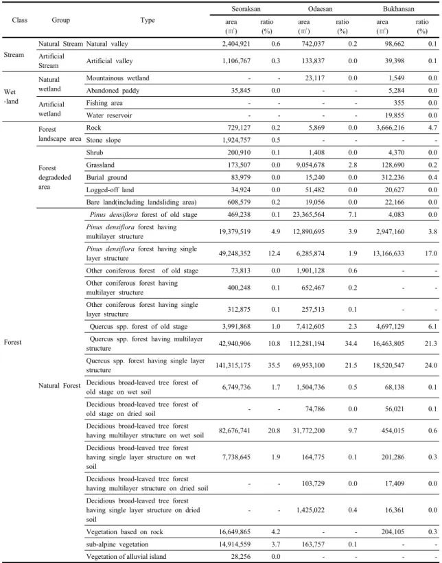
설악산국립공원, 오대산국립공원, 북한산국립공원 등 세 개의 국립공원 유형을 목록화 한 결과(Table 2), 대분 류는 하천, 습지, 산림, 경작지, 조성녹지, 시가화지역, 기 타 등 7개 유형으로 구분되었고, 중분류유형은 자연형하 천, 인공형하천, 자연형습지, 인공형습지, 산림경관지, 산 림훼손지, 자연림, 인공림, 혼효림, 습윤지성경작지, 건조 지성경작지, 소규모조성녹지, 역사시설지, 휴양기반시설지,
Class Group Type
Indicator(Factor) Ref. Indicator(Factor) Ref.
Stream ∙ Maintenance area(naturalness)
1, 2, 3, 4, 6, 10,
∙ Maintenance area(naturalness)
1, 2, 3, 4, 6, 10 Wetland ∙ Maintenance area(naturalness) ∙ Formation type(rareness)
∙ Construct type(utilization)
Forest
∙ Forest landscape(landscape) 3
∙ Geographic formation
(ecological function) 5
∙ Forest landscape degradation
(restoration ability) 10
∙ Forest vegetation formation type
(naturalness) 2, 4, 6, 10
∙ Vegetation growth period
(Stability and utilization) 2, 7, 10
∙ Vegetation layer structure(Stability) 2, 3, 6, 10
∙ Soil moisture(ecological function) 2, 10
∙ Rare vegetation type(rareness) 2, 4, 6, 10 Artificial green ∙ Green scale(utilization) 6, 10 ∙ species type(nativeness) 2, 10 Farmland ∙ Soil moisture
(ecological function) 2 ∙ Formation type(cultivated property) 2, 10 Urbanized area ∙ Historical & cultural value
(historicity․culturalness) 9 ∙ Facility type(Facility property) 8, 9
*1: Ministry of Environment, 2008, 2: Goyangsi, 2008, 3: Kim, 2005, 4: Ra and Lee, 2000, 5: Korea Forest Service, 2009, 6:
Siheungsi, 2007, 7: Yoo et al., 2007, 8: Jeon et al., 2004, 9: Cho et al., 2009, 10: Choi, 2009 Table 1. Indicators of biotope classification and evaluation
일반시설지, 조사불가능지 등 총 16개이었다. 소분류유 형은 설악산국립공원이 42개 유형, 오대산국립공원이 41개 유형, 북한산국립공원이 49유형이었다(Table 2).
산림의 장령림 구분 기준이 되는 평균 흉고직경급 분 석결과, 설악산국립공원은 평균 흉고직경이 39 cm, 오대 산국립공원은 평균 흉고직경이 43 cm로 도출되었고, 북 한산국립공원은 평균 흉고직경이 29 cm로 분석되었다.
이에 따라, 장령을 구분하는 기준으로 평균흉고직경 기 준은 오대산과 설악산은 40 cm, 북한산국립공원은 30 cm로 설정하였다. 설악산국립공원은 조사불가능지를 제 외한 대분류 6개, 중분류 13개, 소분류 42개 등으로 유형 화 되었다. 대분류 유형 중 대부분이 산림(98.7%)이었 고, 하천 0.9%, 시가화지역 0.3%, 경작지 0.2% 등의 순 으로 분포하였다. 하천유형 중 자연형 계곡 하천은 산림 계곡의 중․상류부가 포함되었으며, 인공형 계곡 하천은 공원 내부 한계천, 쌍천, 영실천 등의 계곡부 하류가 포함 되었다. 습지유형 중 자연형 습지는 과거 논경작지가 휴 경에 의해 묵논습지화된 지역이었으며, 대부분 공원 경 계부 설악동 일대에 분포하였다. 산림유형은 산림경관지
인 암반이 전체면적의 0.2%이었고, 울산바위, 공룡능선 등이 포함되었다. 전석지 및 너덜지대는 전체면적의 0.5%이었고, 귀때기청봉 일대 등 능선부에 산발적으로 분포하였다. 산림훼손지는 전체면적의 0.3%로 분포하였 다. 자연림은 전체의 97.2%이었고, 전체 면적의 17.4%
인 소나무림은 대부분의 능선을 중심으로 분포하였다.
기타침엽수림은 전체면적의 0.2%이었고, 참나무류림은 전체면적의 47.3%이었다. 대청봉일대와 신선봉일대를 중심으로 아고산식생이 전체면적의 3.7%로 분포하였고, 저항령계곡과 한계천일대에 하중도식생이 발달하였다.
또한, 황철나무림을 포함한 단층구조의 습윤지성 낙엽활 엽수림은 전체 면적의 1.9%이었고, 저항령계곡에 넓게 분포하였다. 인공림은 전체의 0.1%이었고, 혼효림은 전 체의 0.4%이었다. 장령의 인공림 침엽수림은 백담지구 에 일부 분포하였다. 경작지유형은 논, 밭, 과수원 묘포장 등이었고, 대부분 공원 경계부에 산발적으로 분포하였다.
조성녹지유형은 소규모 자생종 우점의 조성녹지, 외래종 우점의 조성녹지가 분포하였고, 시가화지역 유형은 역사 시설지인 사찰, 휴양기반시설인 주차장, 공원관리시설
Class Group Type
Seoraksan Odaesan Bukhansan
area (㎡)
ratio (%)
area (㎡)
ratio (%)
area (㎡)
ratio (%)
Stream
Natural Stream Natural valley 2,404,921 0.6 742,037 0.2 98,662 0.1
Artificial
Stream Artificial valley 1,106,767 0.3 133,837 0.0 39,398 0.1
Wet -land
Natural wetland
Mountainous wetland - - 23,117 0.0 1,549 0.0
Abandoned paddy 35,845 0.0 - - 5,284 0.0
Artificial wetland
Fishing area - - - - 355 0.0
Water reservoir - - - - 19,855 0.0
Forest
Forest landscape area
Rock 729,127 0.2 5,869 0.0 3,666,216 4.7
Stone slope 1,924,757 0.5 - - - -
Forest degradeded area
Shrub 200,910 0.1 1,408 0.0 4,370 0.0
Grassland 173,507 0.0 9,054,678 2.8 128,690 0.2
Burial ground 83,979 0.0 15,240 0.0 312,236 0.4
Logged-off land 34,924 0.0 51,482 0.0 20,627 0.0
Bare land(including landsliding area) 608,579 0.2 19,056 0.0 22,166 0.0
Natural Forest
Pinus densiflora forest of old stage 469,238 0.1 23,365,564 7.1 4,083 0.0 Pinus densiflora forest having
multilayer structure 19,379,519 4.9 12,890,695 3.9 2,947,160 3.8
Pinus densiflora forest having single
layer structure 49,248,352 12.4 6,285,874 1.9 13,166,633 17.0
Other coniferous forest of old stage 73,813 0.0 1,901,128 0.6 - -
Other coniferous forest having
multilayer structure 400,248 0.1 652,467 0.2 - -
Other coniferous forest having single
layer structure 312,875 0.1 257,513 0.1 - -
Quercus spp. forest of old stage 3,991,868 1.0 7,412,605 2.3 4,697,129 6.1 Quercus spp. forest having multilayer
structure 42,940,906 10.8 112,281,194 34.4 16,463,805 21.3
Quercus spp. forest having single layer
structure 141,315,175 35.5 69,953,100 21.5 18,520,547 24.0
Decidious broad-leaved tree forest of
old stage on wet soil 6,749,736 1.7 1,504,736 0.5 68,138 0.1
Decidious broad-leaved tree forest of
old stage on dried soil - - 74,786 0.0 56,021 0.1
Decidious broad-leaved tree forest
having multilayer structure on wet soil 82,676,741 20.8 31,772,200 9.7 454,015 0.6 Decidious broad-leaved tree forest
having single layer structure on wet soil
7,738,645 1.9 164,775 0.1 201,286 0.3
Decidious broad-leaved tree forest
having multilayer structure on dried soil - - 103,729 0.0 17,409 0.0
Decidious broad-leaved tree forest having single layer structure on dried soil
- - 1,425,022 0.4 16,361 0.0
Vegetation based on rock 16,649,865 4.2 - - 204,105 0.3
sub-alpine vegetation 14,914,559 3.7 163,757 0.1 - -
Vegetation of alluvial island 28,256 0.0 - - - -
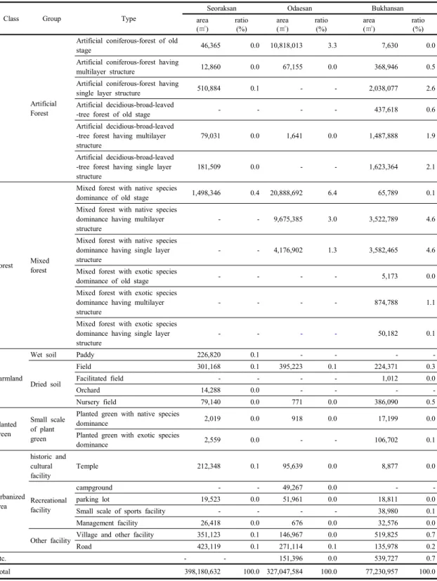
Table 2. Area and ratio according to the biotope types
Class Group Type
Seoraksan Odaesan Bukhansan
area (㎡)
ratio (%)
area (㎡)
ratio (%)
area (㎡)
ratio (%)
Artificial Forest
Artificial coniferous-forest of old
stage 46,365 0.0 10,818,013 3.3 7,630 0.0
Artificial coniferous-forest having
multilayer structure 12,860 0.0 67,155 0.0 368,946 0.5
Artificial coniferous-forest having
single layer structure 510,884 0.1 - - 2,038,077 2.6
Artificial decidious-broad-leaved
-tree forest of old stage - - - - 437,618 0.6
Artificial decidious-broad-leaved -tree forest having multilayer structure
79,031 0.0 1,641 0.0 1,487,888 1.9
Artificial decidious-broad-leaved -tree forest having single layer structure
181,509 0.0 - - 1,623,364 2.1
Forest Mixed forest
Mixed forest with native species
dominance of old stage 1,498,346 0.4 20,888,692 6.4 65,789 0.1
Mixed forest with native species dominance having multilayer structure
- - 9,675,385 3.0 3,522,789 4.6
Mixed forest with native species dominance having single layer structure
- - 4,176,902 1.3 3,582,465 4.6
Mixed forest with exotic species
dominance of old stage - - - - 5,173 0.0
Mixed forest with exotic species dominance having multilayer structure
- - - - 874,788 1.1
Mixed forest with exotic species dominance having single layer structure
- - - - 50,182 0.1
Farmland
Wet soil Paddy 226,820 0.1 - - - -
Dried soil
Field 301,168 0.1 395,223 0.1 224,371 0.3
Facilitated field - - - - 1,012 0.0
Orchard 14,288 0.0 - - - -
Nursery field 79,140 0.0 771 0.0 386,090 0.5
Planted green
Small scale of plant green
Planted green with native species
dominance 2,019 0.0 918 0.0 17,199 0.0
Planted green with exotic species
dominance 2,559 0.0 - - 106,702 0.1
Urbanized area
historic and cultural facility
Temple 212,348 0.1 95,639 0.0 8,877 0.0
Recreational facility
campground - - 49,267 0.0 - -
parking lot 19,523 0.0 51,961 0.0 18,811 0.0
Small scale of sports facility - - - - 38,980 0.1
Management facility 26,418 0.0 676 0.0 32,576 0.0
Other facility Village and other facility 351,123 0.1 146,967 0.0 519,825 0.7
Road 423,119 0.1 271,114 0.1 135,978 0.2
Etc. - - 151,396 0.0 539,727 0.7
Total 398,180,632 100.0 327,047,584 100.0 77,230,957 100.0
Table 2. continue
유형 등이 포함되었다. 기타 일반시설은 마을의 기타 건 축물과 접근 도로 유형이 포함되었다.
오대산국립공은 조사불가능지를 제외한 대분류 7개, 중분류 13개, 소분류 40개이었다. 대분류 유형 중 대부 분이 산림(99.6%)이었고, 하천 0.2%, 시가화지역 0.1%, 경작지 0.1% 등의 순으로 분포하였다. 하천유형 중 자연 형 계곡 하천은 산림 계곡의 중․상류부가 포함되었다. 인 공형 계곡 하천은 공원 내부의 오대천 계곡부 하류가 포 함되었다. 습지유형 중 자연형 습지는 질뫼늪, 소황병산 늪, 조개동늪 등 3개소의 산지습지이었다. 산림유형은 산 림경관지인 암반이 삼선암 일대에 소규모로 분포하였다.
산림훼손지는 전체면적의 2.8%이었다. 자연림은 전체의 82.8%이었고, 전체 면적의 12.9%인 소나무림은 백두대 간을 중심으로 표고가 낮은 동측 소금강지구 일대에 주 로 분포하였다. 기타침엽수림은 전체면적의 0.9%이었 고, 전나무, 잣나무, 주목 등 침엽수림이 다양하게 분포하 였다. 참나무류림은 전체면적의 58.2%이었고, 인공림과 혼효림은 각각 3.3%, 10.7%이었다. 특히, 장령의 인공 림 침엽수림은 오대천 인접부 및 공원 경계부에 주로 분 포하였다. 경작지유형은 밭, 묘포장 등이었고, 대부분 병 내리와 동산리의 공원경계부에 산발적으로 분포하였다.
조성녹지유형은 소규모 자생종 우점의 조성녹지가 일부 분포하였다. 시가화지역 유형은 역사시설지인 사찰, 휴 양기반시설인 야영장, 주차장, 공원관리시설 등의 유형 이 포함되었다. 기타 일반시설은 마을의 기타 건축물과 접근 도로 유형이 포함되었다.
북한산국립공원은 조사불가능지를 제외한 대분류 7 개, 중분류 14개, 소분류 48개이었다. 대분류 유형 중 대 부분이 산림(97.1%)이었고, 시가화지역 1.0%, 경작지 0.8%, 하천 0.2%, 조성녹지 0.1% 등의 순으로 분포하였 다. 하천유형 중 자연형 계곡 하천은 산림 저지대를 제외 한 계곡부와 우이령길 교현리 계곡, 사기막골, 송추계곡 상류 등이 포함되었다. 인공형 계곡 하천은 공원 내부 송 추계곡 하류, 정릉계곡 하류, 우이천 하류 등이 포함되었 다. 습지유형 중 자연형 습지는 도봉사 전면 습지의 물봉 선 군락지 이었다. 묵논습지는 송추 울대습지와 상장능 선에서 북한산로로 만나는 일대에 일부 분포하였다. 산 림유형은 산림경관지인 암반이 전체면적의 4.7%이었고, 자운봉, 만장봉 등 북한산국립공원의 주능선을 따라 형 성된 암봉 등이 포함되었다. 산림훼손지는 전체면적의
0.6%로 분포하였다. 자연림은 전체의 73.6%이었고, 전 체 면적의 20.8%인 소나무림은 주로 주능선을 기점으로 서측의 송추지구와 북한산성 지구, 구기지구에 집중 분 포하며 원도봉, 우이, 도봉, 수유, 정릉지구의 능선부를 중심으로 분포하였다. 장령의 소나무림은 송추계곡 상류 부에 일부 분포하였다. 신갈나무림을 중심으로 전체 면 적의 51.4%로 분포하는 참나무류림은 소나무가 집중 분 포하는 지역을 제외 한 대부분의 지역에 분포하였고, 낙 엽활엽수림은 정릉계곡과 우이령일대 계곡부를 중심으 로 일부 분포하였다. 인공림은 전체의 7.7%인 이었고, 혼효림은 10.5%이었다. 장령의 인공림 침엽수림은 송추 계곡과 사패능선이 만나는 일부지역에 분포하였다. 경작 지유형은 주로 밭과 묘포장 유형이 포함되었고, 북한산 성지구, 송추지구 공원 경계인접부에 분포하였다. 조성 녹지유형은 소규모 자생종 우점의 조성녹지와 소규모 외 래종 우점의 조성녹지 유형으로 구분되었다. 시가화지역 유형은 역사시설지인 사찰, 휴양기반시설인 야영 및 휴 양시설, 주차장, 소규모체육시설지, 공원관리시설 유형 등이 포함되었다. 기타 일반시설은 마을의 기타 건축물 과 접근 도로 유형이 포함되었다.
3.2. 비오톱 평가
비오톱 소분류 평가는 공간의 유형, 평가지표의 기준 에 따라 평가되었다(Table 3). 자연형 하천은 다양성 동․
식물의 서식공간으로서 중요한 기능을 하는 지역과 산림 계곡부 하류의 안전성 등을 전제로 하상과 호안이 인공 화 된 지역을 중분류에서 구분하였고, 소분류유형에서는 등급 Ⅰ로 평가하였다. 자연습지 중 묵논습지는 생물다 양성이 높고 야생동물의 중요서식지 역할을 하고 있어 (Francisco et al., 2001) 등급 Ⅰ로 평가하였고, 인공형 습지는 중분류에서 가치 구분을 하였고, 소분류 평가는 등급 Ⅰ로 평가하였다.
산림 중 산림경관 유형은 산림경관지와 산림훼손지유 형을 구분하여 평가하였다. 산림경관지 유형은 지형생성 을 지표로 하여 경관성을 기준으로 평가하였으며, 설악 산국립공원 대부분의 암봉은 등급 Ⅰ로 평가되었다. 산 림훼손지의 경우 자연적 천이가 진행 중인 초지 및 관목 식생지의 경우 등급 Ⅰ로 평가하였고, 묘지, 벌채지, 산림 나지(산사태지역 포함) 등 산림경관훼손 유형은 등급 Ⅱ 으로 평가하였다. 자연림의 경우, 자연성이 높고 식생
Group Spatial type Evaluation indicator
(evaluation factor) Type division key Biotope type grade
Natural Stream Valley Maintenance type
(naturalness) Natural valley Ⅰ
Artificial Stream Valley Maintenance type
(naturalness) Artificial valley Ⅰ
Natural wetland - Formation type
(rareness)
Mountainous wetland,
Abandoned paddy Ⅰ
Artificial wetland - Maintenance type
(naturalness) Fishing area, Water reservoir Ⅰ Forest landscape
area - Geographic formation
(landscape) Rock, Stone slope Ⅰ
Forest
degradeded area - Forest landscape degradation
(restoration ability)
Shrub, Grassland Ⅰ
Burial ground, Logged-off
land, Bare land Ⅱ
Natural Forest
Pinus densiflora forest, Other coniferous forest, Quercus spp. forest, Decidious broad-leaved tree forest
Vegetation layer structure (Stability), Soil moisture (ecological function)
old stage Ⅰ
multilayer structure Ⅱ
single layer structure Ⅲ Rock based area,
sub-alpine area, alluvial island
Rare vegetation type (rareness)
Rock based, sub-alpine,
alluvial island Ⅰ
Artificial Forest
Coniferous forest, Decidious broad-leaved tree forest
Vegetation layer structure (Stability, utilization)
old stage Ⅰ
multilayer structure Ⅱ
single layer structure Ⅲ
Mixed forest
Mixed forest with native species dominance, Mixed forest with exotic species dominance
Vegetation layer structure (naturalness)
Old stage, Native species dominance having multilayer structure
Ⅰ
Old stage, Native species dominance having single layer structure, Exotic species dominance having multilayer structure
Ⅱ
Exotic species dominance
having single layer structure Ⅲ Farmland on wet
soil - Formation type
(cultivated property) Paddy Ⅰ
Farmland on dried
soil - Formation type
(cultivated property)
Field, Facilitated field,
Orchard, Nursery field Ⅱ Small scale of
plant green - Planted species type
(nativeness)
Native species dominance Ⅰ Exotic species dominance Ⅱ Historic and
cultural facility - Facility type
(Facility property) Temple Ⅰ
Recreational facility - Facility type
(Facility property)
campground, Small scale of
sports facility Ⅰ
parking lot, Management
facility Ⅱ
Other facility - Facility type
(Facility property)
Village and other facility Ⅰ
Road Ⅱ
Table 3. Evaluation grade according to the biotope type
Class Biotope group Biotope type Final grade
Group grade Type grade
Stream Natural Stream Ⅰ Natural valley Ⅰ Ⅰ
Artificial Stream Ⅱ Artificial valley Ⅰ Ⅲ
Wetland
Natural wetland Ⅰ Mountainous wetland Ⅰ Ⅰ
Abandoned paddy Ⅰ Ⅰ
Artificial
wetland Ⅱ Fishing area Ⅰ Ⅲ
Water reservoir Ⅰ Ⅲ
Forest
Forest landscape
area Ⅰ Rock Ⅰ Ⅰ
Stone slope Ⅰ Ⅰ
Forest
degradeded area Ⅳ
Shrub Ⅰ Ⅴ
Grassland Ⅰ Ⅴ
Burial ground Ⅲ Ⅵ
Logged-off land Ⅲ Ⅵ
Bare land(including landsliding area) Ⅲ Ⅵ
Natural Forest Ⅰ
Pinus densiflora forest of old stage Ⅰ Ⅰ
Pinus densiflora forest having multilayer structure Ⅱ Ⅱ Pinus densiflora forest having single layer structure Ⅲ Ⅲ
Other coniferous forest of old stage Ⅰ Ⅰ
Other coniferous forest having multilayer structure Ⅱ Ⅱ Other coniferous forest having single layer structure Ⅲ Ⅲ
Quercus spp. forest of old stage Ⅰ Ⅰ
Quercus spp. forest having multilayer structure Ⅱ Ⅱ Quercus spp. forest having single layer structure Ⅲ Ⅲ Decidious broad-leaved tree forest of old stage on wet
soil Ⅰ Ⅰ
Decidious broad-leaved tree forest of old stage on dried
soil Ⅰ Ⅰ
Decidious broad-leaved tree forest having multilayer
structure on wet soil Ⅱ Ⅱ
Decidious broad-leaved tree forest having single layer
structure on wet soil Ⅲ Ⅲ
Decidious broad-leaved tree forest having multilayer
structure on dried soil Ⅱ Ⅱ
Decidious broad-leaved tree forest having single layer
structure on dried soil Ⅲ Ⅲ
Vegetation based on rock Ⅰ Ⅰ
sub-alpine vegetation Ⅰ Ⅰ
Vegetation of alluvial island Ⅰ Ⅰ
Artificial Forest Ⅱ
Artificial coniferous-forest of old stage Ⅰ Ⅲ
Artificial coniferous-forest having multilayer structure Ⅱ Ⅲ Artificial coniferous-forest having single layer structure Ⅲ Ⅳ Artificial decidious-broad-leaved-tree forest of old stage Ⅰ Ⅲ Artificial decidious-broad-leaved-tree forest having
multilayer structure Ⅱ Ⅲ
Artificial decidious-broad-leaved-tree forest having single
layer structure Ⅲ Ⅳ
Table 4. Final grade by Adding Up Estimation Matrix
Class Biotope group Biotope type Final grade
Group grade Type grade
Forest Mixed forest Ⅱ
Mixed forest with native species dominance of old stage Ⅰ Ⅲ Mixed forest with native species dominance having
multilayer structure Ⅰ Ⅲ
Mixed forest with native species dominance having single
layer structure Ⅱ Ⅲ
Mixed forest with exotic species dominance of old stage Ⅱ Ⅲ Mixed forest with exotic species dominance having
multilayer structure Ⅱ Ⅲ
Mixed forest with exotic species dominance having single
layer structure Ⅲ Ⅳ
Farmland
Wet soil Ⅲ Paddy Ⅰ Ⅲ
Dried soil Ⅳ
Field Ⅱ Ⅴ
Facilitated field Ⅱ Ⅴ
Orchard Ⅱ Ⅴ
Nursery field Ⅱ Ⅴ
Planted green
Small scale of
plant green Ⅳ Planted green with native species dominance Ⅰ Ⅴ
Planted green with exotic species dominance Ⅱ Ⅴ
Urbanized area
Historic and
cultural facility Ⅴ Temple Ⅰ Ⅵ
Recreational
facility Ⅴ
campground Ⅰ Ⅶ
parking lot Ⅱ Ⅶ
Small scale of sports facility Ⅰ Ⅶ
Management facility Ⅱ Ⅶ
Other facility Ⅴ Vilage and other facility Ⅰ Ⅶ
Road Ⅱ Ⅶ
Etc. - Inhibited area - -
Table 4. continue
발달기간이 길수록 안정성이 높고, 고유식생경관을 형성 하기 때문에, 자연성이 높은 장령의 자연림을 높게 평가 (등급 Ⅰ)하였고, 장령에 포함되지는 않지만 다층구조의 안정적 식생구조를 갖는 자연림을 등급 Ⅱ, 수령이 적고 단층구조는 등급 Ⅲ으로 평가하였다. 특히, 아고산식생 과 하중도식생, 암반식생지 등은 생물다양성 측면에서 중요하며, 회귀성이 높아 등급 Ⅰ로 평가하였다. 장령의 인공림은 야생생물의 서식지 기능을 고려하여 등급 Ⅰ로 평가하였고, 생물 서식지측면에서 다층구조의 인공림은 등급 Ⅱ, 단층구조의 인공림은 등급 Ⅲ으로 평가하였다.
혼효림은 자연성을 평가항목으로 하여 식생유형과 식생 층위구조의 복수의 평가지표를 적용하였다. 소분류 유형 중 자생종이 우점하면서 다층구조인 유형을 가장 높게
평가하였고, 외래종 우점이면서 단층구조인 유형을 가장 낮게 평가하였다.
경작지는 토양 습도조건에 따라 구분되었으며, 습윤 지성경작지는 주민의 생산 터전이자 생물다양성이 높은 논 습지는 등급 Ⅰ로 평가하였고, 건조지성 경작지는 등 급 Ⅱ로 평가하였다. 조성녹지 유형은 소규모의 녹지만 이 분포하였고, 우점하는 식재수종유형의 자생성을 기준 으로하여 소분류 등급을 부여하였다. 자생종 우점의 조 성녹지는 등급 Ⅰ로 평가하였고, 외래종 우점의 조성녹 지는 등급 Ⅱ으로 평가하였다. 시가화지역 유형은 역사․
문화성에 따른 시설지 종류로 소분류 평가를 실시하였다.
역사․문화시설지인 사찰은 대부분 문화재 및 오래된 고건 축물을 보유하고 있어 역사문화시설의 보전적 측면에서
등급 Ⅰ을 부여하였다. 국립공원의 휴양을 위한 기반시 설인 자동차야영장, 소규모체육시설지 등은 등급 Ⅰ, 주 차장, 공원관리시설 등은 휴양을 위한 이용성을 기준으 로 하여 등급 Ⅱ로 평가하였다. 일반시설지는 마을 및 기 타시설는 등급 Ⅰ, 도로는 등급 Ⅱ으로 평가하였다.
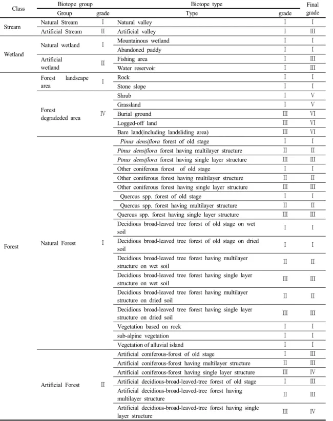
비오톱 중분류 유형 가중치는 생물다양성 보전측면에 서의 중요성을 고려하여 소분류 유형 평가의 범위를 보 정하는 개념으로 설정하며, Choi(2009)에 의해 제시된 비오톱 평가 모형상의 중분류 평가등급을 기반으로 하여, 자연형 하천 및 습지, 산림 경관지, 자연림 등은 등급 Ⅰ, 인공형 하천 및 습지, 인공림, 혼효림 등은 등급 Ⅱ, 습윤 지성 경작지, 소규모 조성녹지는 등급 Ⅲ, 산림 훼손지 및 건조지성 경작지 등은 등급 Ⅳ, 기타 시가화지역은 등급
Ⅴ로 구분하였다.
서식지의 생물다양성 기능 측면에서의 최종 가치 등 급 산정은 비오톱 소분류 유형평가와 중분류 유형 가중 치 부여를 통한 합산평가매트릭스방법을 통해 가치평가 하였다(Table 4). 하천 유형 중 자연형 계곡 하천은 등급
Ⅰ로 평가되었고, 인공형 계곡 하천은 등급 Ⅲ으로 평가 되었다. 습지는 자연형 습지인 산지 습지와 묵논 습지가 등급 Ⅰ로 평가되었다.
산림은 등급 Ⅰ~ Ⅵ까지 평가하였으며, 등급 Ⅰ은 장 령의 소나무림, 참나무류림, 습윤지성 낙엽활엽수 자연 림, 아고산식생, 하중도식생, 암반식생 등이었다. 등급 Ⅱ 는 다층구조의 자연림 이었고, 층위가 형성되지 않은 자 연림과 장령 및 다층구조의 인공림, 장령의, 다층, 단층 구조의 자생종 우점의 횬효림과 다층구조의 외래종 우점 혼효림은 등급 Ⅲ이었다. 습윤지성 경작지인 논은 등급
Ⅲ으로 구분되었고, 건조지성 밭, 과수원, 묘포장 등 경작 지유형은 중분류 가중치를 적용하여 등급 Ⅴ이었다. 휴 식 및 운동공간으로 공원 경계부에 조성된 조성녹지는 등급 Ⅴ~Ⅵ이었다. 시가화비오톱 유형은 최종적으로 등 급 Ⅵ~Ⅶ으로 평가되었고, 역사시설지인 사찰은 등급 Ⅵ 으로 구분하였다. 자동차야영장, 소규모체육시설지, 기 타 시가화지역 등은 모두 등급 Ⅶ로 구분하였다.
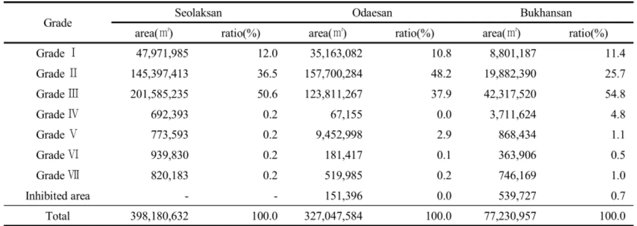
비오톱 유형 평가 등급별 면적 및 비율을 분석한 결과 (Table 5), 설악산국립공원의 등급 Ⅰ지역은 전체 면적 의 12.0%이었고, 모두 생물다양성 및 자연성이 뛰어나 고 안정화된 비오톱 유형이었다. 산림 계곡부 상류와 중 류의 자연형 계곡 하천, 울산바위 등 주요봉우리 및 기존
연구에서 우수한 자연식생군집(Lee et al., 1997a; Lee et al., 1998b)으로 확인된 주전골, 백담계곡, 점봉산 등 장령의 자연림, 아고산식생, 하중도식생, 암반식생 등의 희귀식생유형의 자연림 등이 포함되었다. 등급 Ⅱ지역은 전체 면적의 36.5%이었고, 소나무, 참나무류, 기타침엽 수 등 다층구조의 자연림이 포함되었다. 등급 Ⅲ은 전체 면적의 50.6%이었고, 인공형 하천 및 단층구조의 자연 림 등이 포함되었다. 등급 Ⅳ는 전체면적의 0.2%이었고, 다층구조의 인공림 및 혼효림이 포함되었다. 등급 Ⅴ지 역은 0.2%이었고, 관목식생지, 초지 등 산림훼손지 및 밭, 묘포장 등 경작지 유형이 포함되었다. 등급 Ⅵ지역은 0.2%이었고, 사찰 및 산림나지, 묘지 등을 포함하였다.
등급 Ⅶ지역은 대부분의 시가화지역이었고, 0.2%이었 다.
오대산국립공원의 경우, 비오톱 유형 평과 등급 Ⅰ지 역은 자연하천 및 습지, 암반, 장령의 자연림 등의 유형을 포함하였고, 전체 면적의 10.8%이었다. 모두 생물다양 성 및 자연성이 뛰어나고 안정화된 비오톱 유형이었다.
람사르습지인 질뫼늪, 소황병산늪, 조개동늪 등과 기존 연구를 통해 우수식생군집(Lee et al., 2008)으로 확인된 장령의 월정사 전나무림, 상원사일대의 전나무 및 낙엽 활엽수림, 소금강일대의 대경목의 소나무림 등이 포함되 었다. 등급 Ⅱ지역은 전체 면적의 48.2%이었고, 인공형 하천과 습지, 다층구조의 자연림 등의 유형이 포함되었 다. 등급 Ⅲ지역은 전체 면적의 37.9%이었고, 인공형 하 천 및 습지, 단층구조의 자연림, 장령의 인공림 등이 포함 되었다. 등급 Ⅳ지역은 다층구조의 인공림 및 혼효림이 포함되었고, 면적 비율은 미미하였다. 등급 Ⅴ지역은 2.9%이었고, 관목식생지, 초지 등 산림훼손지 및 밭, 묘 포장 등 경작지 유형이 포함되었다. 등급 Ⅵ지역은 0.1%
이었고, 사찰 및 산림나지, 묘지 등을 포함하였다. 등급
Ⅶ지역은 대부분의 시가화지역이 포함되었다.
북한산국립공원은 등급 Ⅰ지역이 전체 면적의 11.4%
이었고, 모두 생물다양성 및 자연성이 뛰어나고 안정화 된 비오톱 유형이었다. 산림 계곡부 상류와 중류의 자연 형 계곡 하천, 도봉사 전면습지 등 산지습지, 국립공원 특 별보호구역으로 관리 되고 있는 송추 울대습지 등 묵논 습지, 산림 주요봉우리, 장령의 자연림 등이 포함되었다.
등급 Ⅱ지역은 전체 면적의 25.7%이었고, 소나무, 참나 무류, 기타침엽수 등 다층구조의 자연림이 포함되었다.
Grade Seolaksan Odaesan Bukhansan
area(㎡) ratio(%) area(㎡) ratio(%) area(㎡) ratio(%)
Grade Ⅰ 47,971,985 12.0 35,163,082 10.8 8,801,187 11.4
Grade Ⅱ 145,397,413 36.5 157,700,284 48.2 19,882,390 25.7
Grade Ⅲ 201,585,235 50.6 123,811,267 37.9 42,317,520 54.8
Grade Ⅳ 692,393 0.2 67,155 0.0 3,711,624 4.8
Grade Ⅴ 773,593 0.2 9,452,998 2.9 868,434 1.1
Grade Ⅵ 939,830 0.2 181,417 0.1 363,906 0.5
Grade Ⅶ 820,183 0.2 519,985 0.2 746,169 1.0
Inhibited area - - 151,396 0.0 539,727 0.7
Total 398,180,632 100.0 327,047,584 100.0 77,230,957 100.0
Table 5. Area and ratio according to the biotope evaluation grade
등급 Ⅲ지역은 전체 면적의 54.8%이었고, 인공형 하천 및 단층구조의 자연림 등이 포함되었다. 등급 Ⅳ는 전체 면적의 4.8%이었고, 다층구조의 인공림 및 혼효림이 포 함되었다. 등급 Ⅴ지역은 1.1%이었고, 관목식생지, 초지 등 산림훼손지 및 밭, 묘포장 등 경작지 유형이 포함되었 다. 등급 Ⅵ지역은 0.5%이었고, 사찰 및 산림나지, 묘지 등을 포함하였다. 등급 Ⅶ지역은 대부분의 시가화지역 이었고, 전체면적의 1.0%이었다.
비오톱평가 결과, 경관·생물다양성 측면에서 우수한 설악산국립공원, 오대산국립공원내 비오톱 Ⅰ,Ⅱ 등급의 면적 비율이 각각 48.5%, 59.0%이었으며, 도시근교형 의 북한산국립공원(37.1%)보다 높게 분포하였다.
4. 결 론
본 연구는 우리나라 국립공원을 대상으로 하여 생태 적 가치 기반의 공간 관리를 위한 비오톱 유형화 및 평가 틀을 제안하고자 하였다. 생물다양성이 우수한 설악산국 립공원과 오대산 국립공원, 도시근교형의 북한산국립공 원 등을 대상으로 하여 자연성, 희귀성, 경관성, 안전성, 자생성 등의 항목과 관련된 지표를 적용하였으며, 이를 통해, 설악산국립공원은 43개 유형, 오대산국립공원, 41 개 유형, 북한산국립공원 49개 유형으로 구분하였다. 소 분류 3개 등급과 중분류 5개 등급에 대한 합산메트릭스 평가를 통해 최종 7개의 등급으로 공간의 가치를 구분한 결과, 비오톱 Ⅰ등급 지역은 기존 연구에서 확인된 생태 적으로 우수한 식생군집 및 습지 등을 포함하였다. 비오
톱 Ⅰ, Ⅱ 등급을 합한 비율은 설악산국립공원이 48.5%, 오대산국립공원 59.0%, 북한산국립공원 37.1% 등이었 고, 도시근교형의 북한산국립공원의 비율이 상대적으로 낮았다.
본 연구는 기존 도시 공간 관리에 집중된 비오톱 활용 연 구를 보호지역의 범위로 확장 하였다는 데에 의의가 있 다. 연구의 한계로는 비오톱 유형화 및 평가 적용 틀을 제 시하였으나, 지표 및 기준 설정에 대한 정밀성 보완은 필 요할 것이며, 국립공원 관리에 대한 활용 연구 등이 후속 되어야 할 것으로 판단된다.
REFERENCES