Using High-resolution Formosat-2 Images to Study Landslides Caused by Morakot Typhoon
Hsueh-Chun Sha1*, Meng-Chieh Lee 1, Yuei-An Liou1
1. Center for Space and Remote Sensing Research, National Central University, Taiwan, [email protected]
ABSTRACT:
Because of the properties of steep terrain and vulnerable geology of mountainous area of Taiwan and land overuse by humans, hazardous natural events such as typhoon and heavy rainfalls frequently cause mudflows and landslides.
Typhoon Morakot lashed southern Taiwan and caused the most severe landslides in the mountainous area in recent decades. In this study, we use Formosat-2 satellite imagery to identify the changes of surface after this typhoon disaster and investigate different environment factors on this catastrophic landslides generation. According to statistics from Central Weather Bureau, the day accumulation rainfall was over 1,000 mm during typhoon period. Our research areas are Qishan and Lounong watersheds on which the most severe landslide occurred and a total of 229 new landslide sites are found. The geology of this area was sedimentary rocks and low-grade metamorphic rocks influenced by fault and fold. The huge rainfall, and unstable geology and topography are the main factors that cause the landslide in southern part of Taiwan.
KEY WORDS:Formosat-2 satellite imagery, landslides, environment factors
1. INTRODUCTION
Taiwan is an island that lies on the western edge of the Pacific-rim earthquake belt between the boundary of the Eurasian and Philippine Sea Plates, which is an extremely active tectonic region with seismic activities among the highest in the world. The sharp mountains and drastic changes in weather also results in great erosion of the surface rock and soil. All these have resulted in great risk potential for losses of people life and properties.
Furthermore, the excessive utilization of land also resulted in more problems during a natural disaster.
The summer of this year, the typhoon Morakot struck Taiwan during the Aug.5 to Aug. 10, bringing record amounts of rain and washing out roads and bridges. Typhoon Morakot dropped some 2,000 millimeters (80 inches) of rain in Taiwan Aug. 8, causing the worst flooding in five decades, which caused soil erosion. Rivers have burst their banks, washing away buildings, roads and bridges, cutting power lines and flooding city streets as well as farmland.
We use Formosat-2 images to study the disaster areas before and after the disaster in Southern Taiwan.
The disaster areas we concerned are on the two major distributaries of Kaoping River, Nanzihsiian River and Laonong River, in Kaohsiung County in southern Taiwan.
The purpose of this paper is to analyze environment factors such as slope, aspect, altitude, river, and geology to explain why the Lounong watershed crumbled so drastically.
2. MONITORING ON DISASTER AREA In order to understand the aftermath of the landslide disaster in Southern Taiwan, we use Formosat-2 images to monitor the calamity area and edit the landslide sites by the editor module of Arc GIS. The result shows that a total of 229 new landslide sites in southern part of Taiwan are formed after the disaster, and the total area of the landslide sites is 6548.2 ha, and the measure of the largest landslide area is 357.0 ha which is located in Taoyuau township of Kaohsiung county (Figure 1.). The residential district in the disaster area, differentiating from hi-resolution Formosat-2 images, is completely covered by sandstone and mud (Figure 2.), and the landslide area is about 241.7 ha. It was reported that there were 395 households and about 780 residents in Xiaolin village when the disaster occurred, but, based on information, only about 200 people departed from disaster. Typhoon Morakot also resulted in many landslide dams on the mountain areas, especially in the upper river of Qishan and Lounong watershed because of landslide, mudslide and obstruction of magma. The landslide dams would break and cause other disasters, which threaten the lives and wealth of residents in the downstream area (Figure 3.).
Figure 2. Landslide in Xiaolin village
Figure 3. landslide dam with Qishan river
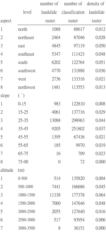
3. ENVIRONMENTAL FACTORS ANALYSIS This study focues on Lounong watershed where the most severe landslide occurred (Figure 4), and we discussed potential possibility of environment factors that caused the landslide. We combine and overlap the
raster data of the landslide area with the slope, aspect, altitude, river, and geology data and perform the zonal statistics analysis. The results show that there are 174 new landslide sites, and the most landslides occur between 1,000-1,500 m while the average altitude of the study area is 1473.3 m. Also the most landslides occur between 25° and 35° slope, and in the eastern, southeast and southern aspects. The highest landslide densities are in Sanhsia Group, Lushan Formation, and Sulo Formation from the geology view, and are in argillite, slate, phyllite, and sandstone interbeds from the lithology view. We could learn from the above information that a mountain area is not suitable to human use if its slope is too steep and its geology was vulnerable.
Table 1. Density of landslide raster
number of number of density of landslide classification landslide aspect
level
raster raster raster
1 north 1088 88617 0.012
2 northeast 2464 87046 0.028
3 east 4845 97119 0.050
4 southeast 5347 111423 0.048
5 south 6202 122764 0.051
6 southwest 4770 131888 0.036
7 west 2736 133316 0.021
8 northwest 1481 113553 0.013
slope ( ° )
1 0-15 983 122810 0.008
2 15-25 4061 137716 0.029
3 25-35 13088 298963 0.044
4 35-45 9205 251802 0.037
5 45-55 1395 67436 0.021
6 55-65 185 9970 0.019
7 65-75 16 709 0.023
8 75-90 0 72 0.000
altitude (m)
1 0-500 514 135820 0.004
2 500-1000 7441 166686 0.045
3 1000-1500 11338 177378 0.064
4 1500-2000 7060 147646 0.048
5 2000-2500 2055 127640 0.016
6 2500-3000 517 93954 0.006
7 3000-3500 8 36151 0.000
Figure 1. Landslide in Taoyuan township
8 3500-3941 0 4203 0.000
We also learn that the landslides extend along the river and would threaten seriously the lives and wealth of residents who lived by river. The details was showed in table 1.
4. CONCLUSION
The effect of the disaster caused by Typhoon Morakot was catastrophic in Southern Taiwan. The purpose of this paper is to analyze environment factors to explain why the Lounong watershed crumbled so drastic.
The study indicates that the main reasons are a river passing by, the vulnerable geology, prevailing distributions of soft sedimentary rock sequence and the low-grade metamorphism, and human development. It might arise formidable disaster beyond anticipated when disastrous natural events such as typhoon, downpour, and earthquake occur. The government should focus on sloping fields and watercourse because of the higher probability for landslide occurring to get the information and trend of environment variation.
5. REFERENCES
Gao, J. and C. P. Lo ,1991. Gis modeling of influence of topography and morphology on landslide occurrence on Nelson County, Virginia, USA. Earth Surface Process and Landforms, (18):579-591.
Hearn G. J.,1995. Landslide and erosionhazard mapping at Ok Tedi Cooper Mine, Papua New Guinea.
Quarterly Journal of Engineering Geology, (28):47-60.
Tiziano Coolotta,2003. Landslide Evaluation: The Landslide Hazard Curves, Journalof Geotechnical and Geoenvironmental Engineering, pp.520~528.
Jones, F. O., Embody, D. R., and Peterson, W. C,1961.
Landslides along the Columbia River Valley, Northeasterm Washington, US Geol.Surv.Prof.367: 98.
Yager, R.,1988. On ordered weighted averaging aggregating operators in multi-criteria decision making.
IEEE T ransactions on Systems, Man, and Cybernetics, vol. 8, 183–190.
Grivetz, E. and Shilling F., 2003 Decision Support for Road System Analysis and Modification on the Tahoe National Forest, Environmental Management, 32(2) :218-233 .
Ravan, S. A. and P. S. Roy ,1997. Satellite remote sensing for ecological analysis of forested landscape.
Plant Ecology , 131: 129-141.
Keefer, D.K., 1984. Landslides Caused by Earthquakes, Geol. Soc. Am. Bull., 95, pp.406-421.
Keefer, D.K.,2000. Statistical Analysis of an Earthquake-Induced Landslide Distribution – the 1989 Loma Prieta, California Event, Engineering Geology, 58, pp.231-249.
Figure 4. Landslide with Lounong watershed