재난관리플랫폼을 이용한 도심지 건물군의 지진피해평가
장성현1, 권동희1, 황찬규2, 최수영3, 최민호4*
1계명대학교 토목공학과 석사과정, 2서울벤처대학원대학교 융합산업학과 부교수,
3GEO C&I 공간정보기술연구소 책임연구원, 4계명대학교 건축토목공학부 조교수
Earthquake Damage Assessment of Buildings in Urban Area using Disaster Management Platform
Sung-Hyun Jang1, Dong-Hee Kwon1, Chan-Gyu Hwang2 Soo-Young Choi3, Min-Ho Chey4*
1Master Student, Department of Civil Engineering, Keimyung University
2Associate Professor, Dept. of Convergence Industry, Seoul Venture University
3Senior Researcher, Geospatial Information Technology Institute, GEO C&I
4Assistant Professor, Faculty of Architecture & Civil Engineering, Keimyung University
요 약 지진은 물리적 특성 상 짧은 시간에 광범위한 지역에 큰 피해를 주는 만큼, 지역사회 기능 회복을 위한 복원력 관점의 지진대응 방안이 필요하다. 이를 위해 본 연구에서는 공공데이터포털정보와 재난관리프로그램(Ergo-EQ)을 이 용하여 시나리오지진에 의한 도심지 건물들의 지진피해를 확률론적으로 평가하였다. 대구광역시 달서구 지역의 주요 건물들에 대한 지진피해평가 수행을 위해 해당 지역의 지형데이터를 활용하고 지역의 지질 및 지반 특성을 반영한 지형 도를 작성하였다. 또한, 상기 건물들의 인프라 특성을 포함하는 통합데이터베이스를 Ergo-EQ 프로그램과 연동되도록 수정하고, 각 건물들에 대해 네 단계 손상수준 별 초과확률을 분석하여 각 건물의 손상도를 평가하였다. 일련의 피해분 석 결과를 통해 각 건물별 지진손상도와 이의 영향 인자 특성을 확인하였다.
주제어 : 지진재난, Ergo-EQ, 학교, 관공서, 손상도
Abstract Because of its physical characteristics, earthquake has a great impact on a wide area in a short time, so it needs a resilience based seismic countermeasures to restore the community function.
For this reason, in this study, the seismic damages of urban buildings were assessed stochastically by virtual earthquakes using public data information and disaster management program(Ergo-EQ). A geographical map reflecting geological characteristics of the target area was created with the buildings and topographic data in Dalseo-gu, Daegu City. In addition, an integrated database including building characteristics was modified to be linked with the Ergo-EQ program. The seismic damages for the buildings were evaluated through the exceedance probability of four different damage levels. From the damage results, it can be identified not only the seismic damage of each building, but also the major factors affecting earthquake damage.
Key Words : Earthquake Disaster, Ergo-EQ, School, Government Office, Damage
*This work has been supported by the contract research program through KISTI in 2019.
*Corresponding Author : Min-Ho Chey([email protected])
Received May 4, 2019 Revised June 4, 2019
Accepted June 20, 2019 Published June 28, 2019
최근 10여 년 전부터 국내에서 발생한 지진 현황 자료 에 따르면, 경주지진(2016년 9월 12일, 규모 5.8)과 포 항지진(2017년 11월 15일, 규모 5.4) 발생을 기점으로 하여 지진위험도 상위 지역을 중심으로 유래 없는 지진 발생 빈도가 기록되었다[1]. 한편, 국내 5 개 주요 도시들 의 등재해도 스펙트럼에 대한 연구 결과에 따르면, 대구·
경북지역의 최대 도시로서 250여만 명의 인구가 밀집되 어 있는 대구광역시가 국내 5대 도시 중 가장 높은 지진 위험도(2,500년 재현주기)를 기록하고 있는 것으로 평가 되었다[2,3].
지진다발지역에서는 지진피해를 감소시키기 위해 일 반적으로 개별 구조물의 내진설계 및 내진보강의 방법으 로 지진저항력을 높이는 것이 1차적인 대응 방안이다. 하 지만, 사회경제적 차원의 피해까지 포함하는 거시적이고 실질적인 지진방재 효과를 얻기 위해서는 도시와 지역 차원의 지진피해예측과 이에 따른 재난복구대책이 실현 될 수 있도록 유도하는 방안이 필요하다. 특히, 우리나라 와 같이 국토공간정보 및 인프라정보에 대한 개방성이 높고 이의 효율적 활용을 위한 IT기술이 우수한 나라에 서는 다양한 시나리오지진 기반의 입체적 지진피해평가 를 통해 지역 및 국가 범위의 지진방재 전략을 도모할 필 요가 있다[4].
Year No. of Mag. 3 or Higher EQs
No. of Sensible
EQs Total No. of EQs
2007 2 5 42
2008 10 7 46
2009 10 10 60
2010 5 5 42
2011 14 7 52
2012 9 4 56
2013 18 48 93
2014 8 11 49
2015 5 7 44
2016 34 55 252
2017 19 98 223
Total 134 224 959
Table 1. Number of earthquakes per year (Earthquake annals of the Korea meteorological
administration, 2017)
대구광역시 달서구 지역의 지형정보 및 인프라정보를 활 용하여 지역 학교 및 관공서에 대한 지진피해평가를 수 행하고자 하였다. 이러한 입체적이고 광범위한 데이터 기 반의 융복합적 문제해결 방안을 통해 지역 주요 인프라 에 대한 지진피해평가뿐만 아니라 추후 해당 지역의 신 뢰성 높은 재난복원력평가에도 기여할 수 있을 것으로 판단된다.
2. 지진피해평가 프로그램
본 연구에서는 지역 기반의 지진피해평가를 위해 MAE(Mid America Earthquake Center, 미국 중부지 진센터)와 NCSA(National Center for Super Computing Applications, 미국 슈퍼컴퓨팅센터)가 공동 개발한 지 진피해평가 플랫폼인 Ergo-EQ를 사용하였다[5-7].
Ergo-EQ는 지진에 의한 구조물의 단계 별 손상확률과 평균손상도 뿐만 아니라 교량, 라이프라인, 나아가 비구 조요소에 대한 피해 분석도 가능하다. 또한, 빅데이터 분 석에 있어서도 다른 유사한 프로그램들이 세밀한 분석 작업이나 다양한 유형으로 구성된 데이터를 처리하는 과 정에서 취약한 구조를 가지고 있는 반면, Fig. 1, 2와 같 이 Ergo-EQ는 다양한 유형의 파일로 구성된 빅데이터 를 많은 알고리즘을 사용해 일괄처리가 가능하도록 시스 템이 설계되었다. 또한 Ergo-EQ는 지속 · 장기적 리스 크 분석 및 관리 가 용이하며, 내진성능목표 달성을 위한 의사결정 측면에서의 강점도 가지고 있다.
Fig. 1. 3D visualized seismic damage using Ergo-EQ
Fig. 2. Data flow of distributed & parallel framework (Ergo-EQ)
3. 대상지역 및 시나리오지진 설정
본 연구에서는 대구광역시 달서구 지역의 학교 및 관 공서 건물을 대상으로 지진피해평가를 수행하였으며, 이 를 위해 지역 인근의 달성단층 활동으로 지진이 발생했 다는 가정 하에 시나리오지진을 설정하였다. 달성단층은 아직 지형조사가 완료되지 않은 단층이지만, 달서구 지역 에서 다소 불리하게 지진피해가 평가될 수 있도록 단층 의 유형, 경사각, 방위각 및 차후각 등의 특성을 적용하여 평가를 수행하였다.
Table 2와 Table 3은 각각 Ergo–EQ에 적용된 달성 단층의 입력정보와 적용된 두 가지 시나리오지진의 특징 을 기술한 것이다. 적용된 시나리오지진은 포항지진의 규 모(M 5.4)와 진원 깊이(7 km)를 그대로 사용하여 진앙 지점을 설정하였고, 이 보다 큰 규모(6.5)의 시나리오지 진을 비교대상으로 함께 적용하였다. 진앙거리는 진앙지 에서 달서구청까지의 거리가 13.1 km, 가장 인접한 거 리는 7.5 km, 또한 가장 먼 지점은 20 km로 측정되었 다. Fig. 3
Type Dip angle Azimuth angle Rake angle
Normal 90° 130° 176°
Table 2. Fault information
Earthquake Lat. Long. Mag. Depth
(km) Scenario 1
35.9N 128.4E 6.5 7
Scenario 2 5.4 7
Table 3. Scenario earthquakes used
Fig. 3. Location of the epicenter adopted
Fig. 4와 Fig. 5는 적용된 두 지진의 특성값들과 한반 도 지반 특성을 반영한 지반감쇠식(Eq. (1))이 적용된 지 진 및 지반환경 하에 달서구 지역에서 나타나는 최대지 반가속도(PGA, Peak Ground Acceleration) 분포를 시각화한 것이다. 붉은색이 진할수록 높은 값의 PGA를 위미하며, 적용된 달성단층의 파열 특성 또한 PGA 값과 분포에 영향을 미친다[8,9].
ln ln
(1)
y : Spectral Acceleration (g) C₁: -2.17 (Strike slip),
-1.92 (Reverse and thrust earthquake) C₂: 1.0 C₃: 1.70
C₄: 2.186 3(M≤6.5) C₅ : 0.32 (M≤6.5) C₄: 0.3825 (M>6.5) C₅ : 0.5882 (M>6.5) rrup : Cclosest distance
Fig. 4. PGA distribution of Dalseo-gu region (Scenario 1)
Fig. 5. PGA distribution of Dalseo-gu region (Scenario 2)
4. 데이터 적용
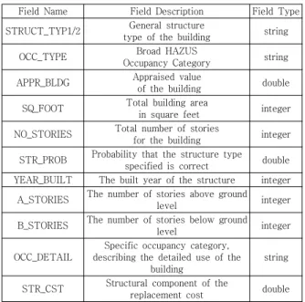
본 연구에서는 달서구지역 소재 학교(초, 중, 고) 건물 62개소와 관공서(구청, 소방서, 경찰서) 건물 21개소를 포함, 총 83개소 건물에 대한 지진피해평가를 위해 국가 공간정보포털의 건축통합정보 및 해당지역의 지형도정보 를 활용하였다. 활용된 데이터로는 건물용도, 건물가치, 준공연도, 구조재료, 연면적 등 주요 건축정보와 위치정 보 등이다. Table 4는 Ergo-EQ에서 사용된 상기 데이 터 항목들을 기술한 것이다[10-12].
Field Name Field Description Field Type STRUCT_TYP1/2 General structure
type of the building string
OCC_TYPE Broad HAZUS
Occupancy Category string
APPR_BLDG Appraised value
of the building double SQ_FOOT Total building area
in square feet integer NO_STORIES Total number of stories
for the building integer STR_PROB Probability that the structure type
specified is correct double YEAR_BUILT The built year of the structure integer
A_STORIES The number of stories above ground
level integer
B_STORIES The number of stories below ground
level integer
OCC_DETAIL
Specific occupancy category, describing the detailed use of the
building
string
STR_CST Structural component of the
replacement cost double
Table 4. Building information (Ergo-EQ)
Ergo-EQ를 통한 지진피해평가에서는 지진(Earthquake
각종 구조물(건물, 교량, 라이프라인 등)들이 해당 구조물 의 고유한 취약도 특성에 따라 물리적 손상을 입게 되는 기본적 피해분석의 순서를 따른다. Fig. 6
Fig. 6. Flowchart of damage assessment (Ergo-EQ)
5. 손상도 분석
Ergo-EQ에서는 지진으로 인한 구조물의 물리적 손상 수준을 경미(Insignificant), 보통(Moderate), 심각 (Heavy), 완전파괴(Complete) 등의 4단계로 구분하며, 이러한 단계 별 손상확률은 P(I), P(M), P(H), P(C)의 항 목으로 각각 표현할 수 있다. 본 연구의 지진피해평가 대 상 구조물의 대표적인 구조형식인 철근콘크리트 구조물 에 대한 단계 별 손상수준은 Table 5와 같이 정의된다.
Damage State Description
Insignificant (I)
Flexural or shear type hairline cracks in some beams and columns near joints or within joints.
Moderate
(M) Most beams and columns exhibit hairline cracks.
Heavy (H)
Some of the frame elements have reached their ultimate capacity indicated in ductile frames by large flexural cracks, spalled concrete and buckled main reinforcement
Complete (C)
Structure is collapsed or in imminent danger of collapse due to brittle failure of nonductile frame elements or loss of frame stability.
Table 5. Description of damage states
단계 별 손상확률을 계산하기 위해 먼저 해당 구조물 의 내진성능평가에 따라 변위스펙트럼(Sd)과 가속도스펙 트럼(Sa)으로 표현되는 성능점을 도출하고, 세 단계의 거
동한계상태(즉시거주-Immediate Occupancy(IS), 인 명안전-Life Safety(LS), 붕괴방지-Collapse Prevention(CP)) 별 초과확률을 반영하는 취약도곡선 (Fig. 7)을 생성한다. 이를 이용해 관계식 Eq. (2)를 적용 하여 해당 스펙트럼가속도(또는 변위)에 따른 단계 별 손 상확률을 상대적 비율의 개념으로 도출할 수 있다 [13-15].
Fig. 7. Computing probabilities of damage states
P(I) = 1 – P(IO) P(M) = P(IO) - P(LS) P(H) = P(LS) - P(CP) P(C) = P(CP)
(2)
최종적으로 상기의 단계 별 손상확률비율에 대한 평균 값(Mean)을 Eq. (3)을 통해 계산하여, 각 구조물들에 대 한 평균손상도(μD)를 구하게 된다. 식에서 i는 네 가지 손 상수준으로서, 이들 수준 별 손상도 비율에 대한 확률모 델은 Table 6과 같다.
· (3)
Damage states,
DSi
Range of Beta distribution (%)
Mean of damage ratio, μD|DSi (%)
Standard deviation of damage ratio, σD|DSi
(%)
1: I [0, 1] 0.5 0.333
2: M [1, 30] 15.5 9.67
3: H [30, 80] 55 16.7
4: C [80, 100] 90 6.67
Table 6. Probabilistic model for structural damage ratio
적용된 두 가지 시나리오지진에 의한 달서구지역 지진 피해평가 결과, 전반적으로 사용된 두 시나리오에서 비슷 한 피해 양상을 보였다. Fig. 8은 시나리오 1에 대한 평 균손상도를 시각화한 것으로 전반적으로 진앙지와 가까 운 거리의 건물들에서 상대적으로 큰 손상도가 나타나는 것을 확인할 수 있다. Fig. 9 및 Fig. 10은 평가 대상 83 개 건물들의 준공연도에 따른 손상도분포를 나타낸 것이다.
Fig. 8. Damage distribution of the buildings in Dalseo-gu Region (scenario 1)
Fig. 9. Mean damage VS. year of built (scenario 1)
Fig. 10. Mean damage VS. year of built (scenario 2)
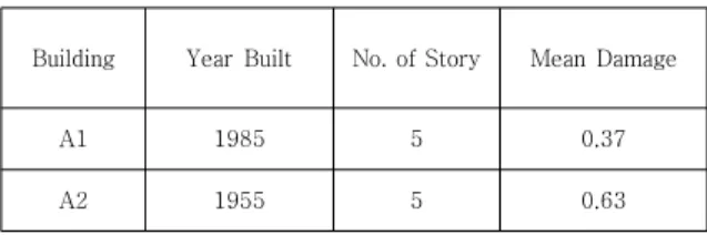
의 층수 및 연면적을 기준으로 손상도를 분석하였다. A 단위는 비슷한 규모(층수 및 연면적)지만 준공연도에 차 이가 있는 경우로서, 평균손상도에서 분명한 차이(0.37
→ 0.63)를 보였다. B 단위는 준공연도에는 차이가 있으 나 연면적(건물규모) 차이의 영향으로 오히려 비슷한 손 상도를 보이는 경우이다.
Building Year Built No. of Story Mean Damage
A1 1985 5 0.37
A2 1955 5 0.63
Table 7. Mean damage VS. built year and story
Building Built Year (No. of story)
Total Floor Area (ft2)
Mean Damage
B1 1991 (4) 28,585 0.39
B2 1963 (5) 76,927 0.37
B3 1984 (5) 62,977 0.36
Table 8. Mean damage VS. built year and total floor area
6. 결론
본 연구에서는 기존의 개별 구조물 차원의 내진성능평 가를 통한 지진대응이라는 지엽적 한계를 극복하기 위한 방안으로, 도심 지역의 물리적 지진손상에 따른 사회경제 적 재난복원력 향상을 목표로 도심 기반의 지진피해평가를 수행하였다. 이를 위해 지진피해평가 플랫폼(Ergo-EQ) 을 활용, 대구광역시 달서구지역의 학교 및 관공서 건물 들을 대상으로 두 가지 시나리오지진에 따른 지진피해를 평가하였으며, 다음과 같은 결론을 도출하였다.
l 사용된 지진피해평가 플랫폼(Ergo-EQ)은 적용된 지진, 단층, 지반, 인프라 특성의 영향을 신뢰성을 확인할 수 있는 수준에서 통합적으로 잘 반영하였 다.
l 지진손상도를 결정하는 여러 인자 중, 구조물의 준
도 파악되나, 평가 대상 건물 수의 한계로 일반적 결론을 도출하기에는 부족하였다.
l 피해예측에 대한 보다 높은 신뢰성을 확보하기 위 해서는 적용되는 시나리오지진, 활성단층, 지반특 성에 대한 보다 정확한 데이터 반영과 함께 충분한 양의 인벤토리 확보가 필요할 것으로 판단된다.
본 연구의 결과를 바탕으로 추후 기타 인프라(교량, 도 로망, 상하수도관망 등) 피해예측으로의 확대 적용과 해 당 지역의 신뢰성 있는 지진환경 및 인프라정보의 도입 으로 지역재난복원력 평가를 위한 기술정책적 방안도 마 련할 수 있을 것으로 기대된다.
REFERENCES
[1] H. K. Kim. (2017). 9.12 Records of earthquake and subsequent 180 days. Korea : Ministry of Public Safety and Security.
[2] J. K. Kim, S. H. Wee & J. B. Kyung. (2016). Uniform Hazard Spectra of 5 Major Cities in Korea. The Korean Journal of the Earth Science Society, 37(3), 162-172.
[3] J. B. Kung, M. J, Kim, S. J. Lee & J. K. Kim. (2016). An Analysis of Probabilistic Seismic Hazard in the Korean Peninsula- Probabilistic Peak Ground Acceleration (PGA). The Korean Journal of the Earth Science Society, 37(1), 52-61.
[4] G. H. Jung, H. S. Lee, O. S. Kwon & K. R. Hwang.
(2016). Earthquake Direct Economic Loss Estimation of Building Structures in Gangnam-Gu District in Seoul Using HAZUS Framework. The Korean Journal of the Earth Science Society, 20(6), 391-400.
[5] S. S. Chai, S. Y. Jang & D. J. Suh. (2018). Design and Implementation of Big Data Analytics Framework for Disaster Risk Assessment. The Korean Journal of Digital Contents Society, 19(4), 771-777.
[6] C. S. Jung. (2013). A Study on Enhancement of Recovery Procedure of Mobile Communication Base stations Subjected to Seismic Loads. Doctoral dissertation, SVU University, Seoul.
[7] C. H. Hwang. (2013) A Study on Urban Damage Assessment by Earthquake Damage Assessment System. Doctoral dissertation, SVU University, Seoul.
[8] K. Sadigh, C. Y. Chang, J. A. Egan, F. Makdisi & R. R.
Youngs. (1997). Attenuation Relationships for Shallow Crustal Earthquakes based on California Strong Motion Data. Research of seismological, 68(1)
180-189.
[9] S. Y. Kang, K. H. Kim, B. C. Suk, H. S. Yoo (2007).
Attenuation Relations in HAZUS for Earthquake Loss Estimations in Korea. The Korean Journal the Earth Science Society 58(6), 15-21.
[10] J. S. Steelman, J. H Song, J. F. Hajjar. (2007). Systemic Validation of Consequence-Based Risk Management for Seismic Regional Losses. Illinois : Mid-America Earthquake center.
[11] K. H. Jung, H. J. Lee, B. C. Park, K. H. Kim. (2003).
Study for the Establishment of Earthquake Disaster Information System. Korea : National Disaster Management Institute.
[12] C. S. Lee et al. (2015). Development of Seismic Fragilities for Urban Infrastructure Network. Seoul : UOS.
[13] J. E. Daniell. (2011). Open Source Procedure for Assessment of Loss using Global Earthquake Modelling software (OPAL). Journal of Natural and Hazards Earth System Sciences, 11(7), 1885-1899.
[14] MAE Center. (2009). Impact of New Madrid Seismic Zone Earthquakes on the Central USA. Illinois : Mid-America Earthquake center.
[15] M. H. Chey, D. H. Kwon, S. H. Jang. (2018). Seismic Damage Assessment of the Buildings in Dalseo-gu, Daegu City, using Ergo-EQ Program. KSCE Magazine.
Nov. 2018. (pp.76-79). Seoul : KSCE PRESS.
장 성 현(Sung-Hyun Jang) [학생회원]
․ 2017년 2월 : 계명대학교 건축토목 공학부(학사)
․ 2017년 3월 ~ 현재 : 계명대학교 토목 공학과 석사과정
․ 관심분야 : 빅데이터, U-City 지진방 재
․ E-Mail : [email protected]
권 동 희(Dong-Hee Kwon) [학생회원]
․ 2017년 2월 : 계명대학교 건축토목 공학부(공학사)
․ 2017년 3월 ~ 현재 : 계명대학교 토목 공학과 석사과정
․ 관심분야 : 열차진동, 비구조요소 내진, 빅데이터
․ E-Mail : [email protected]
황 찬 규(Chan-Gyu Hwang) [정회원]
․ 1988년 2월 : 서울대학교 토목공학 과(공학사)
․ 1990년 2월 : 서울대학교 토목공학과 (공학석사)
․ 1999년 2월 : 코넬대 토목환경 공학 과(공학박사)
․ 2005년 3월 ~ 현재 : 서울벤처대학원 대학교 U-City학과 부교수
․ 관심 분야 : 빅데이터, U-City, 데이터 러닝
․ E-Mail : [email protected]
최 수 영(Soo-Young Choi) [정회원]
․ 2009년 2월 : 계명대학교 토목공학과 (공학사)
․ 2011년 8월 : 계명대학교 토목공학과 (공학석사)
․ 2011년 3월 ~ 현재 : GEO C&I 공간 정보기술연구소 책임연구원
․ 관심분야 : GIS, 빅데이터
․ E-Mail : [email protected]
최 민 호(Min-Ho Chey) [정회원]
․ 1992년 2월 : 동아대학교 건축공학 과(공학사)
․ 2001년 4월 : 캔터베리대 토목공학과 (공학석사)
․ 2008년 5월 : 캔터베리대 토목공학과 (공학박사)
․ 2014년 3월 ~ 현재 : 계명대학교 건 축토목공학부 조교수
․ 관심분야 : 면제진구조설계, 데이터 기반 도시방재
․ E-Mail : [email protected]