SETTING CRITERIA AND MAPPING METHOD FOR NATIONAL ECOLOGICAL NETWORK USING ENVIRONMENTAL
INFORMATION IN SOUTH KOREA
Joungyoon Chun, Seongwoo Jeon
Korea Environment Institute (KEI), [email protected], [email protected] ABSTRACT ...
Ecological network is a planning tool which can be easily apply for spatial planning or environmental plan. But there are no criteria and implication tool of that. So we present in this study that the concept of national ecological network of Korea(NEN) and the criteria and mapping method for its application. NEN has 4 axis classified forest, river, wildlife and coast axis. Each axis has 16 conservative evaluation items, they are composed of environmental or ecological, topological and law criteria. Whole items were modified into Grid format by 30m x 30m resolutions and has 5 steps on methodology; a) absolute evaluation b) relative evaluation c) exclusion of built up areas d) forest patch analysis e) connectivity analysis. After 5 steps of evaluation, the area of core areas was 29,942 ㎢, buffer zones covered 22,324 ㎢, and each accounted for 30% and 23% of national land. Forest axis and river axis was clearly linear form and connected each other, but wildlife axis was dispersed with point form. Therefore, for applying the NEN, it is important that detail habitat map and interconnect implementation among forest, river, wildlife and coast axis of NEN should be necessary.
KEY WORDS: National ecological network, axis, corridor, spatial planning, conservation areas
1. INTRODUCTION
Last half of 20th century, S. Korea has accomplished economic growth very fast so that many developing countries in East Asia and others want to learn and chase the economic growth model of S. Korea. However, compressed economic growth and industrial developments induce many developing actions to the landscape so that significant degradation and loss of habitats have taken place.
In the late 1970s, a concept of ecological network as a spatial planning method has its origin in both in Europe and North America in population dynamics, community ecology and landscape and spatial ecology (Pulliam, 1988; Ricklefs and Schluter, 1993; Smith and Hellmund, 1993; Forman, 1995; Dias, 1996; Farina, 1998; Naveh, 2001; Opdam et al., 2002; Fortin and Dale, 2005; ECNC1, 2008).
In S. Korea, national environment plan (2006~2015) and basic plan of natural environment (2006~2015) has been executed and they contained a concept of core ecological network and it is composed of DMZ2, Baecdu- daegan and coastal areas. And they presented the environmental management range which composed by Han-river with Seoul metropolitan range, Geum-river with Chungcheong range, Youngsan-river with Honam range, Nakdong-river with Youngnam range and Taebaek-Gangwon range.
In this study, we present the concept of national ecological network of Korea(NEN) and the criteria and mapping method for its application.
1 European Centre for Nature Conservation
2 Demilitarized zone
2. A CONCEPT OF NEN
National Ecological Network is flowing ecological habitats containing spatial and ecological connectivity.
The concept was derived by natural environmental law (2004). Through the NEN, unified and systematic approach will be available to nature conservation policies.
And it can be more easily apply to spatial planning.
3. MATERIALS AND METHODS 3.1 Axis and evaluation items
There are four axis of NEN, forest axis, river axis, wildlife axis and coast axis are presented in this study.
The criteria for evaluation and mapping the ecological network are composed of environmental or ecological, topographic and law items. First, in law, forest axis has 11 evaluate items by 8 individual laws. And river axis has 2 items by 2 individual laws. Wildlife axis has 1items by 1 law. Second, in environmental or ecological items, there are 5criteria which are comprised by 10 evaluating items. Third, in topographic items, 2 evaluating items are suggested in this paper.
Whole items of each part of criteria are made by Government of S. Korea, and its dataset are latest version.
To evaluate and handling of dataset, all geographic dataset was exchanged by GRID format, which resolution is 30x30(meter, 1:25,000).
Table1. Conservative evaluation items
Criter ia
items Conservative evaluation items
Evaluation method Envir
onme
Ecosystem conservation
▪1grade area Absolute
▪2grade ▪2grade area near Relative
ntal or ecolo gical
area map(a) the 1grade
▪2grade area remainder
Forest map(a)
▪5,6 wood age Relative
▪3,4 wood age River
(b)
▪national, local 1grade river Absolute
▪national river: 500m buffer zone
▪local 1grade river: 250m buffer zone
wetland (a, b)
▪wetland(extracted by land cover map3)
Absolute
Specified species discovered
area (c)
▪mammal: 500m buffer zone around mid-greate mammal and rare or endangered species discovered areas
▪bird: 500m buffer zone around rare or endangered species counted areas
Absolute
topog raphic
jeongmak (a)
▪1st watershed area Absolute
Drainage area
(a)
▪1st watershed area by standard watershed map
Relative
law protection area by law
(a,b,c,d)
▪protection area (baeckdu-daegan,
ecological-landscape,
natural park(national, provincial, county), wild fauna and flora , special wild fauna and flora , forest for genetic resources , natural monument, DMZ, conservation forests, wetland, waterside, environ. conservation sea, special management sea, marine resources, special islands
Absolute
Etc. exclu sion
Use d are a
▪built-up areas by land cover map and environmental impact assessment & prior environmental review - mountains in basic plan of natural
environment-
-
(a) : forest axis, (b) : river axis, (c) wildlife axis, (d) coast axis
3.2 Forest axis
Environmental or ecological criteria have 2 thematic maps, ecosystem conservation area map and forest map.
In this study, we use 1st and 2nd grade of Ecological conservation area map and 3~6 wood age of forest map.
3 Land cover map is classified by 23 codes
In topographic criteria, jeongmak and drainage area dataset reflect the regional relativities of each local land.
The dataset was deducted by hydrological analysis of ArcGIS, and the source data was DEM and watershed map.
In law criteria, 11 law-origin protected area map was used. The lists of protected area are showed by table 1.
3.3 River axis
River system is classified national and local 1st and 2nd river by river law. Our study, we use national and local 1st river and these buffer zones. The wetland data we used in this thesis is the inland wet area which was extracted by the 510 code of land cover map. We used the latest land cover map made in 2008 using the ©SPOT images of ministry of environment (ME).
3.4 Wildlife axis
Wildlife axis has 3 thematic maps. It is composed by Protection area of wild fauna and flora, special wild fauna and flora and specified species discovered area. The dataset of specified species was extracted on fauna and flora distribution map made by ME.
3.5 Coast axis
Coast axis has 8 thematic maps. Environmental conservation sea and special management sea are protected by sea environment management law. Coastal wetland is designated by wetland conservation law. And ecological-landscape conservation area is protected by natural environment conservation law. Marine resources protection area is protected by planning and use of national land law. Special island is designated by special law for ecology conservation of Dok-do and other islands.
Coast axis also has non-protected areas. Wetland is made by extracted area, code 520 of land cover map, and a dataset of tidalflat produced by ministry of land, transport and maritime affairs. In this study, just showing of coast axis was available, because the coast areas are not managed by ME.
3.6 Evaluation methods
Making the NEN methodology of land area has 5 steps.
Methodological steps are involved starting with absolute evaluation, evaluating relative criteria, exclusion of used areas, analysing of forest patch and finally connectivity analysis.
Absolute evaluation is conducted on ecological significant area or high worth of conservation. Core area and buffer zone are divided by evaluation. The outcome of evaluation is divided core areas and buffer zones. Core areas contain important species or habitats(J. A. Klijn, A.
J. F. M. wan Opstal & I. M. Bouwma, 2003) and protected area. Buffer zones around core areas is safeguard areas from negative influences from surrounding areas ( J. A. Klijn, A. J. F. M. wan Opstal &
I. M. Bouwma, 2003).
Relative evaluation is conducted for peculiar local properties. It uses a grading method, sum of grades of each conservative evaluation item is reclassified by core areas and buffer zones.
Exclusion of used area is performed after overlaying absolute and relative evaluation. Built-up areas of land cover map and project areas exported by environmental impact assessment & prior environmental review are merged into used areas.
Through Forest patch size analysis, it is available that habitat size estimation. Habitat size is important for ecological stability and species diversity (MacArthur, Wilson, 1967). For analysing forest patch, we use 310, 320 and 330 codes of land cover map which classified by forests and extracted the patch size over 1,000ha.
Connectivity analysis is conducted by two steps. First, through core areas analysis, small size core areas are eliminated. Second, using the neighbourhood analysis (Plotnick and Gardner, 1993, R. H. Gardner and R. V.
O’Neill, 2001), interconnectivity of adjacent cell of evaluated area can be analysed.
4. RESULTS AND DISCUSSION 4.1 Area and spatial distribution
After 5 steps of evaluation, the area of core areas was 29,942 ㎢, buffer zones covered 22,324 ㎢, and each accounted for 30% and 23% of national land. In absolute evaluation, the area of core areas was 29%, buffer zones was 4%. The area of overlay map of absolute and relative evaluation was accounted for 37% and 34%. So it is clearly that the relative evaluation could great role to increase buffer zones. We think drainage area of 1st watershed area by standard watershed map to reflect the local topographic attributes. And exclusion of used area showed that 1% and 3% of core areas and buffer zones decreased. We then selected 30% core areas and 23%
buffer zones after the forest patch analysis. And the result showed that many of western and southern small patches were excluded. Last, from the connectivity analysis, less than 1% of decreases were accounted.
29.22
36.06
30.34 30.22
4.15
33.68
31.43
22.95 22.53
37.12
0 5 10 15 20 25 30 35 40
absolute relative used area forest patch connectivity
core buffer
Figure 1. Variation of core areas and buffer zones of evaluation steps
4.2 axis
From the results of our study, 4 axis was derived.
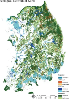
Forest, river, wildlife and coast axis are those. Most of the evaluated area was forest axis and it was counted by 50% of national land. Also the results showed that most patches of forest were connected, so the forest axis can be a significant role to ecological network of S. Korea. River axis was clearly linear form, so it can be a good role to increase the connectivity and make a corridor between separated patches. But not similar to forest and river axis, wildlife axis was dispersed widely of point form. Because of no habitat map and little dataset of wildlife, the area occupied by wildlife axis was very little. It was account for the little survey of wildlife animals. National natural environmental survey has been performed every 10 years by national environmental conservation law, because of lack of budget and qualified specialist. And S. Korea has not habitat map of major species. Coast axis showed around the border of land.
4.3 Implementation of ecological network
Like first mentioned, ecological network can easily apply to spatial planning. First of all, forest axis has clearly connected corridor and almost ecological area occupied so that ecological network and other nature conservation policy reflect the forest axis. River axis has clear linear form so that they play connecting materials (stepping stone) among many dispersed patches. Last, wildlife axis not yet plays independent role in the ecological network, but play a partial role in the NEN by helping of forest and river axis.
Figure 2. Spatial distribution of Ecological Network of Korea
5. CONCLUSIONS
In this study, we presented the concept and evaluation criteria of NEN. And its evaluation was conducted to national land of Korea. Core areas were appointed by 30% and buffer zones were appointed 23% of the national land. And the results of our study, forest axis and river axis were clear linear form and interconnected. But wildlife axis was point form and it was dispersed.
The results showed that the forest axis and river axis can be a significant role to implement the ecological networks. But wildlife axis was not showed linear form so that more dataset of wildlife should be prepared to evaluate ecological network.
References from Journals:
R. H. G. Jongman et al., 2004. European ecological networks and greenways.Landscape and Urban Planning 68( ), pp. 305-319.
References from Books:
MacArthur R. H. and Wilson E. O., 1967, The theory of island biogeography. Princeton University Press, Princeton.
R. H. Gardner and R. V. O’Neill, 2001, Landscape Ecology in theory and practice: pattern and process.
Springer, New York.
References from Other Literature:
J. A. Klijn, A. J. F. M. wan Opstal & I. M. Bouwma, 2003. Indicative map of the Pan-European Ecological Network for central and eastern europe. European Centre for Nature Conservation, Tilburg, The Netherlands.
ACKNOWLEDGEMENTS
This study was part of the “A Study for mapping an ecological network on Nakdong-river with Youngnam range and Youngsan-river with Honam range” and financial supported by Ministry of Environment.