1. Introduction
Imaging sensors provides various type of images depending on the sensor characteristic. The various type of images are often used together to improve the reliability of image fusion and recognition techniques such as the fusion of CCD image and Infrared image for improvement of pedestrian detection performance (Son et al., 2017), the fusion of electro-optical image and infrared image for dual-mode seeker missile (Jung et al., 2017) and the fusion of electro-optical image
and Synthetic Aperture Radar image for urban area classification (Ye, 2012). Imaging sensors of satellites such as Landsat or KOMPSAT (KOrean MultiPurpose SATellite) provide several types of images including RGB and near-infrared (NIR) bands. Image classification is one of the most important technique using the various types of images simultaneously to obtain the information of the scene. Many research studies on image classification have carried out in various application area (Magpantay et al., 2019; Jeon and Kim, 2018; Yoo et al., 2017). Image classification is a process to classify pixels into several groups with
Evaluating the Contribution of Spectral Features to Image Classification Using Class Separability
Chul-Soo Ye
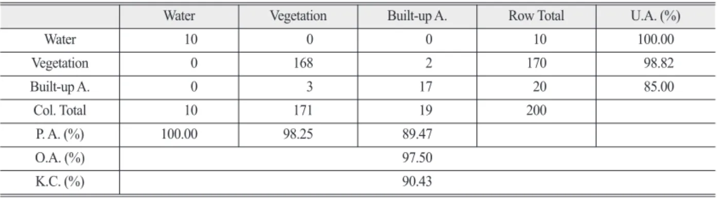
1)†Abstract: Image classification needs the spectral similarity comparison between spectral features of each pixel and the representative spectral features of each class. The spectral similarity is obtained by computing the spectral feature vector distance between the pixel and the class. Each spectral feature contributes differently in the image classification depending on the class separability of the spectral feature, which is computed using a suitable vector distance measure such as the Bhattacharyya distance. We propose a method to determine the weight value of each spectral feature in the computation of feature vector distance for the similarity measurement. The weight value is determined by the ratio between each feature separability value to the total separability values of all the spectral features. We created ten spectral features consisting of seven bands of Landsat-8 OLI image and three indices, NDVI, NDWI and NDBI. For three experimental test sites, we obtained the overall accuracies between 95.0% and 97.5% and the kappa coefficients between 90.43% and 94.47%.
Key Words: image classification, feature selection, class separability Korean Journal of Remote Sensing, Vol.36, No.1, 2020, pp.55~65
https://doi.org/10.7780/kjrs.2020.36.1.5 ISSN 1225-6161 ( Print )
ISSN 2287-9307 (Online)
Article
Received February 7, 2020; Revised February 13, 2020; Accepted February 20, 2020; Published online February 25, 2020
1)
Professor, Department of Aviation and IT Convergence, Far East University
†
Corresponding Author: Chul-Soo Ye ([email protected])
This is an Open-Access article distributed under the terms of the Creative Commons Attribution Non-Commercial License
(http://creativecommons.org/licenses/by-nc/3.0) which permits unrestricted non-commercial use, distribution, and reproduction in
any medium, provided the original work is properly cited.
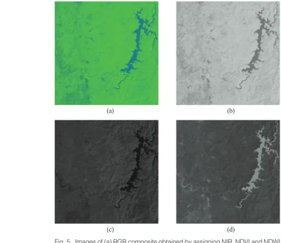
specific attributes. The specific attributes of the earth surface are often detected by optical or microwave sensors. The multispectral bands of optical sensor such as Landsat-8 operational land imager (OLI) are basic sources to distinguish the attributes like vegetation, water, buildings and so on. Each multispectral band has its own spectral property depending on the specific attribute of the earth surface. For example, water has low reflectance property which results in the pixels of dark intensity in the NIR band. Index image such as normalized difference vegetation index (NDVI) (Rouse et al., 1974) has the property that pixels of vigorous vegetation have bright intensity in the NDVI image.
Normalized difference water index (NDWI) (Mcfeeters, 1996) is also a well-known index image used to detect water body, which has relatively bright intensity in the NDWI image.
The index images, however, shows sometimes similar values for other different attributes. For example, grasslands and built-up areas in NDVI and NDWI images were not discriminated from each other (Szabo, 2016). The attributes of the earth surface which have similar spectral property can be distinct from each other by using an additional spectral band or index image. The accuracy of image classification were improved by simply inserting three index images into the Landsat-8 band images (Park et al., 2018). It is common that all features are used in the conventional image classification methods. However, if many features are created by computing spectral or texture property and also are available together in image classification, we need a feature selection method to overcome the problem of efficiency by selecting some relevant features among the features. Nussbaum and Menz (2008) proposed the separability of two classes in the feature to select the most relevant feature to discriminate two classes. The effect of the selected feature on other classes, however, is not considered in their study. In this paper, we analyze the feature selection based on the separability of two classes and
then develop a feature selection method using the separability of all class pairs. We propose a method to select weight values of spectral feature images for multiple classes, which is based on our previous research on the feature weight analysis (Ye, 2019).
2. Methodology
It is common that multiple features are used in image classification. As a feature for the image classification, multi-spectral information such as red, blue and green bands is used to classify the image into multiple classes.
The multi-spectral bands produce index images such as NDVI, NDWI and normalized difference built-up index (NDBI), which are given as follows:
NDVI = (1) NDVI = (2) NDVI = (3) where B represents normally the reflectance of each band. In this study, we use pixel values of each band instead of reflectance because we do not need consider cosine effect due to image acquisition difference and also each index image is rescaled to the range (0, 255) by the min-max normalization.
The NDVI, NDWI and NDBI are useful features to detect vegetation, water and built-up area, respectively.
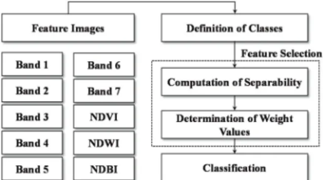
These index images were used as features together with the original Landsat-8 OLI image to classify Landsat- 8 OLI images (Park et al., 2018). We can create spectral features from original band images and also need sometimes to select a part of features or reduce the dimensionality of the features. Fig. 1 shows the overall procedure for the proposed method. After creating index images from Landsat-8 OLI images, we compute the separability of each class pair using the index images together with the seven Landsat-8 band images. The weight value of each feature for image
(B
NIR– B
RED)
(B
NIR+ B
RED)
(B
NIR– B
GREEN)
(B
NIR+ B
GREEN)
(B
SWIR1– B
NIR)
(B
SWIR1+ B
NIR)
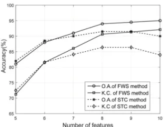
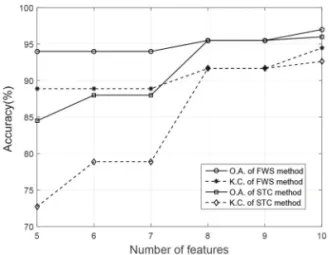
classification is determined by the separability of each class pair. Finally, we classify pixels based on the feature vector distance. In the following sessions, feature selection by the Separability of Two Classes (STC method) and feature selection by feature Weighting based on Separability (FWS) will be explained in detail.
1) Feature Selection by the Separability of Two Classes (STC)
The feature selection is a process to find a subset of features in order to reduce the dimensionality of the features for various purpose. The relevant features which have good separability of two classes are determined by measuring the separability using a suitable distance measure such as the Bhattacharyya distance given as follows:
B = (m
i–m
j)
2+ ln ( ) (4) where (m
i, m
j) and (σ
i, σ
j) are the mean and the variance, respectively, for two classes C
iand C
j. Given a feature image v, v=1, …, V, a measure S
ijvfor the separability of the two classes in the feature v is defined using the Bhattacharyya distance as follows:
S
vij= 2(1 – e
–B) (5) The separabiltiy S
vijis the Jeffries-Matusita distance and is close to zero if the two means and variances are similar to each other, respectively. Nussbaun and Menz (2008) proposed a method to select the most
relevant feature among the features by finding a feature with maximum separability of class pair using the Jeffries-Matusita distance. For example, given three classes, C
i, i=1, 2, 3, the v -th feature value x
vand the mean u
vof v -th feature, we classify pixels using the distance measure D
k, which is a vector distance between the feature vector x and the mean vector u
kof the class C
k, as follows:
D
k= l
v· | x
v– u
vk| ,
(6) l
v= { 0 otherwise 1 if v ∈ {v
12max, v
23max, v
31max}
where v
ijmax= S
vij, v=1, …, V.
The drawbacks of this method is that the separability of the other remaining class pairs. For example, if S
112is maximum, then S
123and S
131is not considered in finding the feature v
12max. The selection of the feature v
ijmaxmay cause positive or negative effect on the separability of S
123and S
131depending on the characteristic of the class C
3. The second drawback is that the number of selected features is basically limited to the number of the class pairs, i.e., one feature is selected for each class pair. This means that some features are not used in image classification. This reduces the possibility of accuracy improvement which may be obtained by the insertion of the features into image classification.
2) Feature Selection by Feature Weighting based on Separability (FWS)
The proposed method for feature selection considers all the separability of the class pairs in each feature v, while the method for feature selection by the separability of two classes uses only one feature with maximum separability for each class pair. We compute the sum J
vof all separability of the class pairs in the featureas follows:
J
v= S
vij(7) The sum J
vrepresents the effect of the feature v on the separability of all class pairs. If the sum J
vhas a high
1 8 2
σ
2i+ σ
2j1 2 σ
2i+ σ
2j2σ
iσ
j∑
V v=1argmax
vN-1
∑
i