http://dx.doi.org/10.7848/ksgpc.2014.32.1.39
이종 위성센서 영상을 이용한 에피폴라 영상 제작
Generation of Epipolar Image Using Different Types of Satellite Sensors Images
성민규1) · 최선용2) · 장세진3)
Sung, Mingyu · Choi, Sunyong · Jang, Sejin
Abstract
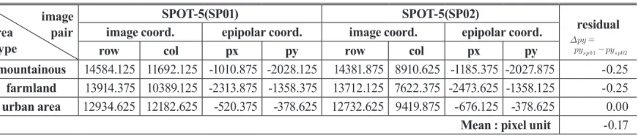
In this study, the epipolar images were created by both methods of resolution adjustment and piecewise approach using RPC(Rational Polynomial coefficients) and ancillary data of IKONOS-2 and SPOT-5 satellite images whose resolutions are different from each other. The stereo geometry of these two satellite images was analyzed and the RPC block modelling was accomplished for generating epipolar images. In order to evaluate the accuracy of created epipolar images, the y-parallaxes were analyzed for the specific points which were apparently identified in mountainous, plain and urban area. Also the RMSEs of the specific points were calculated using the coordinates from the epipolar stereo images and the coordinates from the block triangulation. Y-parallaxes were within one pixel and the RMSEs were within two meters for X, Y and Z each.
Keywords : High Resolution Satellite Image, Picecwise Epipolar, RPC, IKONOS-2, SPOT-5, RMSE
초 록
본 연구에서는 해상도가 서로 다른 고해상 위성영상 IKONOS-2와 SPOT-5 영상의 RPC(Rational Polynomial coefficients)와 위성보조정보 자료 등을 활용하여 해상도 조정 및 piecewise 방법을 적용하여 에피폴라(Epipolar)
영상을 제작하였다. 또한, 에피폴라 영상을 제작하기 위한 선행 작업으로 두 영상의 입체기하 분석과 RPC 블록모
델링을 수행하였다. 제작된 에피폴라 영상의 정확도 평가를 위해 촬영 대상지역 중, 지형의 특성에 따라 산악지, 농 경지, 도심지 및 주거지 등 육안 판독시 식별이 명확한 지점을 세분류하여 Y-시차를 분석하였으며, 이때 사용된 점
을 대상으로 에피폴라 영상의 입체관측을 통해 획득한 3차원 좌표와 원영상의 블록모델링에 의해 계산된 3차원 좌
표 차이의 RMSE를 계산하였다. 분석결과 Y 시차는 1 화소(pixel) 이내, RMSE 오차는 X, Y 및 Z에 대해 2m 이내 임을 확인하였다.
핵심어 : 고해상 위성영상, Piecewise 에피폴라, RPC, IKONOS-2, SPOT-5, RMSE
39 1) Corresponding author · Geographic Information Institute, ChungAng AeroSurvey co., LTD(E-mail: [email protected])
2) Member · Agency for Defense Development(E-mail: [email protected])
3) Member · Geographic Information Institute, ChungAng AeroSurvey co., LTD(E-mail: [email protected])
This is an Open Access article distributed under the terms of the Creative Commons Attribution Non-Commercial License (http://
creativecommons.org/licenses/by-nc/3.0) which permits unrestricted non-commercial use, distribution, and reproduction in any medium, provided the original work is properly cited.
1. 서 론
비약적으로 발전한 수치사진측량, 컴퓨터 관련 분야 및 인 공위성의 기술은 대용량의 고해상도 입체 위성영상 취득 및
이를 이용한 정밀한 3차원 위치정보 추출을 가능하게 하여 대축척 지도 및 정밀 수치표고 제작 등에 다양하게 이용하 고 있다. 3차원 위치정보 추출이 용이한 동일 궤도 입체영상 은 촬영영역이 협소하며, 위성 재방문 주기, 촬영각, 기상상 Orignal article
Received 2014. 01. 21, Revised 2014. 02. 14, Accepted 2014. 02. 28