1
DESIGN OF STANDARD GRIDDED METADATA FOR INTEGRATED MANAGEMENT OF SATELLITE IMAGERY
INFORMATION
Eun young Han and Gee Ju Chae
Telematics and USN Research Division
Electronics and Telecommunications Research Institute {hey63097,cbase} @etri.re.kr
ABSTRACT:
Recently, in Korea, recognizing the importance of satellite imagery and a national project, the development of satellite providing satellite imagery information of 1m high resolution has been carried out.
As the application of satellite imagery information is expanded to the national land, the environment and geographical information, etc, the necessity of integrated management of satellite imagery information increases.
Unfortunately, in case of Korea, currently, the results that institutes for satellite imagery processing produce with satellite imagery have been individually managed.
Integrated Management of Satellite Imagery Information project which is being promoted by ETRI (Electronics and Telecommunication Research Institute) in Korea will provide the solutions for the above mentioned problems.
In this research work, we designed standard metadata for integrated management of satellite imagery information in consideration of international and national standard.
KEY WORDS: Satellite imagery, Standard Metadata, Integrated Management, Geograhical Information
1. INTRODUCTION
The use of satellite imagery is extended as recent technology of remote sensing rapidly develops, and the demand of satellite imagery is increased to conduct spatial analysis
With this trend, since 1990’s, the need of construction of clearing house for distributing satellite imagery has arisen. In oversea, in the center of USA, the satellite images archiving center is running, the use of the satellite images from nongovernmental part as well as governmental part is being spread. Also, Japan and Canada is receiving various satellite images by the initiative of government. And, in order to build the system of distribution for the satellite images, the satellite images archiving center, which saves, manages and distributes the received images, has been founded.
In the case of Korea, satellite KOMPSAT-I has already launched and orbiting. In 2005, satellite KOMPSAT-II carrying the sensor of 1-m resolution imagery is scheduled to launch. Furthermore, in order to apply the images to air and ocean field and GIS(geographical information system) and RS(remote sensing), beyond the conventional view of optic imagery, the need of hyper spectral, SAR, LiDAR images expended more and more
On the other hand, ISO, an international standardization organization, make progress of the standardization of metadata for grid data on the center of FGDC, USA, as the need to increase the efficiency of producing and managing satellite images and the activation of utilizing them is required. In Korea, however, systematic total and management of satellite images is not well because of not exploiting metadata standardization
research result. Thus, It may occur to purchase repeatedly the same satellite images of which price is very high or reproduce the similar satellite images that need much time and cost to produce once. [1]
2. PRESENT:
STATUS OF INTEGRATED MANAGEMENT OF NATIONAL & INTERNATIONAL SATELLITE
IMAGES INFORMATION 2.1 International status
2.1.1 U.S.A.
Owing to NASA(National Aeronautics and Space Administration) and US Department of Defence, the United State of America has been playing an important role to promote and develop space industries and producing satellite images. The Landsat, a remote-sensing satellite has been producing a large number of spatial images information up to recently, even launching Landsat-7.
Moreover, with satellite images, aerial imagery over USA have been being acquired since 1980. These spatial image information is managed by USGS(United State Geological Survery). USGS has several divisions that produce and provide different kinds of spatial information respectively, for example, such as Biological Resources Division, Geologic Division, National Mapping Division and Water Resource Division. Among them, NMD takes charge of generating and managing spatial imagery information. And, also distributes and sales the data to users through various distribution networks. [2]
2 USGS (U.S. Geological Survey) has three Clearing
houses for the distribution of data: EROS (Earth Resources Observation Systems) Data Center Clearinghouse Gateway, Alaska Geospatial Data Clearinghouse Gateway, and GLIS (Global Land Information System) Clearing Gateway. FGDS (Federal Geographic Data Committee) provides the metadata and distribution standard for the USGS.
Standard of Metadata plays an important role to distribute metadata. In NMD, the standard of metadata for distribution made by FGDC(Federal Geographic Data Committee) help receive Metadate from various source.
NASA provides various satellite images from Landsat, NOAA, Corona and SPOT.
Another important project of NMD is the NMP(National Mapping Program) for national map.
NASA
National Mapping Division
FGDC USGS
Satellite Image
Consumer Clearinghouse
(GLIS) Clearinghouse
(Alaska) NMP
business -NAPP -NDOP -LCCP
Clearinghouse (EROS Data Center)
Consumer Consumer Consumer
Figure 1. USA Satellite Imagery Information Service Organization
2.1.2 Canada
In 1962, Canana was the third nation launching an artificial satellite in the world after USA and Ressia. In addition to, in 1972, launching a communication satellite for domestic communication, Canada has driven the research in the field of information technology.
RADARSAT 2 is going to be launched in 2005 after RADARSAT 1 launched in Nov. 1995. Especially, Radar images is mainly acquired rather optical images and is used on various application.
In Canada, CCRS of Geomatics Canada under NRCan(National Resource Canada) receives and manages spatial image information. Geomatics Canada is a governmental organization to manage survey, acquisition and distribution for photogrametry, cartography, remote sensing and GIS. It connects government with organizations through Geomatics Committee and sustains the close collaboration relation with related agencies.
2.1.3 Australia
In Austrailia, ACRES(Australian Centre for Remote Sensing) of AUSLIG(Australian Survey and Land
Information Group) under IRS(Department of Industry Science and Resource) receives, archives, and provides satellite images from Landsat, SPOT, ERS and RADARSA. ACRES discriminates its production with imported images, and acquires, receives satellite image information and distributes it after processing. ACRES have two divisions: DAF(Data Acquisition Facility) and DPF(Data Procession Facility). DAF acquires data of NOAA, MODIS, Landsat 7, SPOT 1~4, RADARSAT and JERS from two receiving antenna located in Alice Spring and Hobart. DPF takes charge of making a catalogue of information and archiving them. ACRES provides two search service: SPOT-LITE Catalogue and Digital Catalogue(TerraServer).
2.1.4 Japan
In Japan, the RESTEC(Remote Sensing Technology Center) collects and spread spatial images, the distributive organization administrated by distributes them to the related agencies and ordinary user. The central organization concerned with spatial images is the NASDA(National Space Development Agency of Japan).
NASDA plays very core role in Space Development Project of Japan and develops space station and remote sensing satellite: MOS and JERS. In addition to, the NASDA is responsible for management of satellite as well as persistent development of space shuttle, space station and remote sensing satellites. The images received by NASDA is provided to RESTEC, which distributes them. RESTEC makes a basic and total research and development for an artificial satellite and remote sensing as well as receive the satellites images and provides to local public bodies, research institutes and universities to apply to the field of environmental analysis, emergency warning and resources investigation. RESTEC provides a service to purchase the product after retrieving data by RADARSAT retrieval system, IRS retrieval system and EUS/WWW.[3]
2.2 Status of Korea
Unlike USGS of USA and RESTEC of Japan, Korea don’t have a satellite images management center that plays a role in receiving and distributing spatial image information nationally. Merely, from 1990s NGIS(National Geographic Information System) is conducted, centring around Korean National Geographic Information Institute(NGI). For digital land information, third year project has been conducted. Moreover, in order to manage and distribute efficiently various digital geographic information, for example, digital map generated by NGIS basic plan, NGIC(National Geographic Information Clearinghouse) is running.
System component and role of NGIC is to manage and operate systematically geographic information provider and consumer through NGIC after building sectional integrated management center around distribution center, especially, to operate governmental system in connection
3 with non governmental system through standardized
geographical information metadata.
On the other hand, domestic satellite images distribution is enabled through importing from abroad and selling in nongovernmental part. Satellite Technology Research Center(SaTRec) launched experimental satellite KITSAT-1(Korea Institute of Technology Satellite-1) in 1992, and constantly KITSAT-3(Korea Institute of Technology Satellite-3) in 1999 through which satellite image information is created for the usage of national research and development and distributed by nongovernmental company. Moreover, STSAT-2(Science and Technology Satellite 2) is expected to launch in Dec., 2005. Furthermore, KARI(Korean Aerospace Research Institute) has made and sold its own satellite images.
KARI launched KOMPSAT-I(Korea Multi-Purpose SATellite I) and built up the organization to distribute to academy, industry and people for the public purpose of using images from electro-optical camera(EOC) and ocean scanning multi-spectral imager(OSMI). The organization is encouraged to promote the field of satellite remote sensing in Korea. [4]
But, Korea don’t have the institute that totally manages and distributes various satellite images that we mentioned above at the national level like USGS in USA.
Thus, ETRI(Electronics Telecommunications Research Institute) has been operating the project of integrated management of satellite image information under the governmental control since 2001 as a fundamental project for wholly managing national and international satellite images and related product and promoting the utilization of satellite images. Moreover, Korean Satellite Imagery Information Management Center(SIMC) is expected to play a role as a satellite image archiving center.[5]
3. STANDARD METADATA SYSTEM DESIGN FOR INTEGRATED SATELLITE IMAGERY INFORMATION
MANAGEMENT 3.1 The presence of SIMC
As mentioned in the previous chapter, SMIC has been being founded and run by ETRI. It intends to save the budget for system construction, manage satellite images systematically and its quality by integrated management.
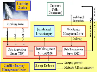
The Integrated Satellite Imagery Information Management System in SIMC constructs the archiving system that plays a central role to manage satellite imagery information database, accomplishment database and metadata database and to manipulate the satellite images transferred from receiving system. Among manipulated data, the data asked through web server by users are provided to the users after the process of searching and ordering. Figure 2 illustrates the web service concept of managing satellite imagery information in SIMC.
The data constructed in SIMC which began to develop in 2001 and now completed in 2005 are 214 scenes in Landsat MSS/TM/ETM+, 95 scenes in SPOT 1, 100
scences in JERS-1, 105 scene in Corona, and 3000 scenes in KOMPSAT-1.
Figure 2 Satellite Imagery Information Service Meanwhile, a record preserving system was planned to manage the archived data efficiently and constantly. And, standard satellite image metadata have been designed to increase the extensibility of the data and the system has been made for recording, managing and archiving the satellite imagery. The task definition, detail design and key technology for a record preserving system.
3.2 The presence of status of abroad standarization of metadata: mainly focussing on ISO/TC211
ISO/TC211(International Organization of Standardization Technical Committee 211) has made
"ISO 19115 Geographic Information - Metadata" since 1996 and the standards have been approved as the international standard in 2003. ISO 19115 defines the schema required for describing geographic information and it provides information for the identification, extent, quality, spatial and temporal schema, and spatial reference and distribution of digital geographic data for vector and gridded data. ISO 19115 has been compromised of two components of the core and comprehensive metadata components.
※ M: Mandatory, C: Conditional, O: Optional Table 1. Core metadata
Dataset title(M) Spatial representation type(O) Dataset reference date(M) Reference system(O) Dataset responsible party Lineage(O)
Geographic location of the
dataset(C) On-line resource(O)
Dataset language(M) Metadata file identifier(O) Dataset character set(C) Metadata standard name(O) Dataset topic category(M) Metadata standard version(O) Spatial resolution of the
dataset(O) Metadata language(O) Abstract describing the
dataset(M) Metadata character set(O) Distribution format(O) Metadata point of contact(M) Additional extent information
for the dataset(O) Metadata date stamp(M)
4 Especially, core metadata(Table 1) consists of the
information mainly for the data identification and should be included when user-defined metadata actually applied.
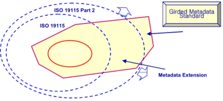
While the ISO 19115 does provide some provisions for imagery and gridded data, the requirements were not fully developed at the time ISO 19115 was drafted. As a result,
"ISO 19115 Part 2 : Extensions for imagery and gridded data" was proposed and approved as a new work item in 2003. This will extend the existing ISO 19115 by defining the schema required for describing imagery and gridded data, mostly in four major sections : identification, data quality, spatial representation, and content
3.3 Standard Metadata System Design for Integrated Satellite Imagery Information Management
Standard metadata system design for integrated satellite imagery information management is accomplished by the data analysis as follows: ISO 19115 Part2, ISO 19129, ISO19130 and remote sensing metadata profile in FGDC, USA. Moreover, the data include provisional NGIS metadata standard in Korea, 1999, geographic information metadata standard for distribution in 2002 and geographic information metadata standard of Korea National Geographic Institute. The analysis of several thematic maps was accomplished to generate various data such as digital elevation models(DEMs), ground control points(GCPs), orthophotography and finally the data is used to develop the accomplishments metadata standard.
And, using these analysis results, satellite imagery and accomplishment metadata standard is presented in conformity with international standard. [Figure 3] shows the design of content model, a extended form of national and international standard metadata,.
Figure 3. Metadata Extensions of ISO 19115 .
4. CONCLUSION
In this paper, as mentioned above, a present state of ‘a project for integrated management of satellite image information’ has been illustrated, and design of grid metadata for managing efficiently satellite image information has been presented. This standard grid metadata will be found, taken and utilized by general public for the purpose of their tasks or research works, if designing national standard grid metadata for distribution of satellite image is completed in the national level in consideration of the national or international present state of standard grid metadata.
References
[1] Gee Ju Chae., 2005. The Issue on Maintenance of Public Security for Satellite Images. IGARSS2005.
[2] USGS Home Page, http://www.usgs.gov [3] RESTEC Home Page, http://www.restec.or.jp [4] Home Page, http://www.kari.re.kr [5] SIMC Home Page, http://simc.etri.re.kr
ISO 19115
ISO 19115 Part 2 Girded Metadata
Standard
Important factor
Metadata Extension