Article
http://dx.doi.org/10.4217/OPR.2015.37.4.249
연구사업 해양자료 관리를 위한 표준화와 해양물리자료 표준(안)
김성대
1*· 최상화
2· 박준용
3· 박수영
21한국해양과학기술원 해양물리연구본부
2한국해양과학기술원 해양관측·자료실
3한국해양과학기술원 해저환경·자원연구본부 (15627) 경기도 안산시 상록구 해안로 787
Data Standardization for Research Ocean-Data Management and Standard Proposal of Physical Oceanographic Data
Sung-Dae Kim
1*, Sang-Hwa Choi
2, Jun-Yong Park
3, and Soo-Young Park
21Physical Oceanography Division, KIOST
2Ocean Observation and Information Section, KIOST
3Marine Geology and Geophysics Division, KIOST Ansan 15627, Korea
Abstract : Standardization work for the ocean data produced by a variety of national oceanographic research projects was conducted in order to establish a national ocean data sharing system. For this work, we first prepared standard proposals for the national research ocean data by reviewing and analyzing of existing international and domestic ocean-data standards. The proposed standards were reviewed and revised by experts in the field of oceanography and academic societies for documentation. The 125-page technical report on the standards of 25 data items was prepared as an output of this research work, which is available free of charge for the public and interested parties. This paper explains the proposed standards of metadata and codes regarding the common properties of all the oceanographic data items. Especially, the standards for the metadata, codes and data formats of 4 physical data items were described in detail. In order to be adopted as the national standards for ocean data, however, the standards suggested here require further development and/or modification based on additional reviews of and ample feedbacks from the relevant academic and technical communities.
Key words : data standardization, metadata standard, physical ocean data, research data, data management
1. 서 론
해양에 대한 물리적, 화학적, 생물적, 지질적, 지구물리 적 특성을 연구하는 과정에서 생산되는 해양과학데이터는 현장에서 관측장비로 측정하는 자료, 시료에 대한 분석자
료, 수치모델 산출자료, 원격탐사자료로 구분할 수 있다.
해양자료 수집에 많은 비용과 시간이 투입되는 만큼, 자료 공유에 대한 요구는 오래전부터 있었으며, 이를 위한 국제 적, 국가적 활동들이 이루어져 왔다(한국해양과학기술원 2014). 상대적으로 자료확보와 품질관리가 용이한 해양물 리자료를 중심으로 다양한 자료유통시스템들이 운영되고 있으며, 최근 들어 다른 분야 자료의 유통시스템들도 증가 하고 있다. 해양 자료와 정보의 처리에서 표준은 매우 중
*Corresponding author. E-mail : [email protected]
요하며, 이에 대한 많은 논의가 있었고 여러 실용적 아이 디어가 개발되고 실행되었으나, 국제표준 개발의 성공 사 례는 많지 않다(ODSBP 2015). 국내외의 연구기관, 국제 기구, 국제 프로그램 등에서는 자체 목적에 따라 다양한 표준을 제시하여 왔으며, 자료에 대한 부가정보인 메타데 이터(metadata)의 표준이 주를 이루고 있다.
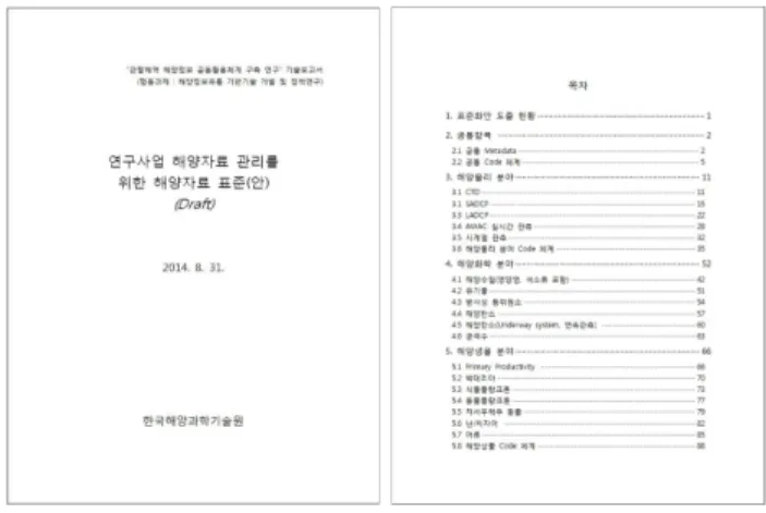
해양수산부에서는 매년 해양연구에 많은 예산을 투입하 고 있으나, 연구사업에서 생산되는 해양자료들은 연구책 임자들이 개별적으로 관리함에 따라 공동활용에 많은 어 려움이 있었다. 이에 해양수산부에서는 해양정보공동활용 체계 구축을 추진하면서, 연구사업 해양자료를 지속적으 로 수집하고 관리할 수 있는 유통체계 구축을 시도하게 되었다. 다수 연구사업에서 생산한 해양자료의 통합 관리, 검색을 위해서 상호호환성 유지가 필수적이며, 이를 위해 표준화된 메타데이터와 자료포맷이 요구된다. 더불어, 자 료의 신뢰성 확보를 위한 품질관리기술의 필요성이 대두 되어, 연구사업 생산자료의 체계적인 관리를 위한 표준화 와 품질관리 기술 개발을 추진하게 되었다. 일차적으로 자 료 및 관련정보 수집이 용이한 해양영토과 연구사업을 대 상으로 기술개발을 수행하고 있으며, 장기적으로는 해양 수산부의 모든 연구과제로 대상을 확대할 계획이다. 우선 적으로 해양영토과 7개 연구사업에서 생산하는 해양자료 항목들을 대상으로 표준화 작업을 수행하였다. 국내외에 서 활용하고 있는 여러 가지 표준에 대한 분석 작업을 수 행하였으며, 이를 기반으로 총 25개 자료항목에 대한 표 준(안)을 마련하였다(Table 1). 전문가 검토, 학계 검토를 거쳐 준비된 표준(안)은 125쪽의 문서(Fig. 3)로 작성되 었으며, 국내에서 자유롭게 사용할 수 있도록 준비되어 있다.
본 논문에서는 이중에서 공통항목과 해양물리 4개 자료 항목에 대한 메타데이터, 자료포맷, 코드체계 표준(안)을 소개하고자 한다. 한국해양과학기술원 메타데이터와 코드 체계(한국해양과학기술원 2014), SeaDataNet 메타데이터 프로파일(Boldrini and Nativi 2012), WOD(World Ocean Database) 자료포맷(NODC 2013), WOCE(World Ocean
Circulation Experiment) 자료포맷(JALADCP 2013, JASADCP 2013) 을 기준으로 물리자료 표준(안)을 도출하 였으며, 전문가들의 개별 검토와 해양학계의 설문조사를 통해 1차적으로 검증하였다. 여기서 제시하는 표준(안)은 추가적인 학문적 검토와 실용적 검토를 통해 지속적으로 개정할 필요가 있다.
2. 표준화 방법
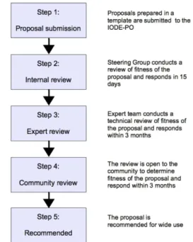
IODE(International Oceanographic Data and Information Exchange) 와 JCOMM(Joint Commission for Ocean- ography Data and Marine Meteorology)에서는 국제적으 로 유통되고 있는 해양자료의 표준 수립을 위하여 Ocean Data Standard and Best Practices Project(ODSBP)를 수행 하고 있다(ODSBP 2015). 이 프로젝트에서는 Fig. 1과 같
Table 1. Ocean-data standards prepared by this study
Group Data item
Common Common Metadata
Physical oceanography CTD, LADCP, SADCP, AWAC Real-time Data, Serial Data
Chemical oceanography Water Quality (inc. Nutrient and Pigment), Organic Matter, Radioisotope, Ocean Carbon, Ocean Carbon (Underway System), Connate Water
Biological oceanography Bacteria, Phytoplankton, Zooplankton, Benthic Invertebrate, Larva and Egg, Fish, Primary Production
Geological oceanography and geophysics Surface Sediment, Core, Deep Sea Core, Depth, Gravity/Magnetic, Shallow Seismic, Deep Seismic
Fig. 1. Standardization procedure of ODSBP (UNESCO
2012)
은 표준화 절차를 수립하고 이에 따라 표준화작업을 수행 하고 있다. 국제기구나 해양기관에서 제안한 표준에 대하 여 내부검토, 전문가검토, 단체검토를 거친 후에 표준 권 고안을 제시하도록 하고 있다. 이번 표준화 작업에서는 ODSBP 절차를 이용하여 자체적인 표준화 절차를 수립하 였다(Fig. 2). 국내외 기존 표준 분석, 표준화 대상 선정, 표준화 도출 과정을 통해 표준(안) 초안을 준비하도록 하 였으며, 준비된 초안에 대하여 전문가 검토 및 단체 검토 를 수행하도록 하였다. 이렇게 도출한 표준(안)은 문서화 를 통해 정리함으로써, 추가적인 광범위한 검토에 대비하 도록 하였다.
앞에서 설명한 표준화 절차에 따라, 국내외 기존 표준 에 대한 분석 작업을 우선 수행하였다. 국제자료유통조 직, 국제공동프로그램, 해양자료센터, 국내해양기관 등에 서 사용하고 있는 표준들을 수집하였으며, 자료교환에 초 점이 있는 자료유통 표준들과 자료항목별 특성을 고려한
표준들로 구분하여 분석하였다. 본 논문에서는 자료유통 표준과 해양물리분야 표준만을 소개한다(Table 2). 두 번 째 절차인 표준화 대상 자료항목 도출을 위하여 해양수 산부 7개 연구사업을 대상으로 해양자료 생산현황을 분 석하였다. 사업별 연차실적계획서, 해양조사계획서 등을 바탕으로 해양물리, 해양화학, 해양생물, 해양지질 및 지 구물리 분야의 총 25개 자료항목을 표준화 대상으로 선 정하였다. 국내외 기존 표준에 대한 분석결과를 바탕으로 연구사업에 적용 가능한 표준(안)을 도출하였다. 표준(안) 은 전체 자료항목에 동일하게 적용하는 공통항목 표준과 개별 자료종류별로 적용하는 자료항목별 표준으로 구성 하였다. 공통항목 표준에서는 해양수산부 연구사업이 단 계별로 운영되는 점, 연구책임자가 바뀔 수 있다는 점 등 연구사업 전반에서 발생 가능한 사항들을 메타데이터로 관리할 수 있도록 하였다. 자료항목별 표준에서는 자료별 특성에 따른 정확도, 품질관리정보, 관측방법, 관측기기 정보들을 위한 메타데이터 항목들과 자료항목별 자료유 통포맷을 제시하였다. 또한, 정보관리 과정에서 반복적으 로 사용되는 정보의 효과적 처리를 위해 코드체계를 제 시하였다.
이렇게 준비한 초안에 대한 전문가 검토를 통해 1차 표 준(안)을 마련하였다. 각 분야별 전문가 모임(10~20인 참 석)을 개최하여 초안을 자세하게 설명하고 개선사항에 대 한 의견을 청취하였다. 이후에 각 전문가를 개별적으로 방 문하여 초안에 대한 의견을 추가로 수집하였다. 제시된 검 토결과를 반영하여 표준(안) 내용을 상세히 설명하는 문서 화 작업을 수행하여 1차 표준(안)을 정리하였다. 이렇게 준비한 1차 표준(안)에 대한 학계 검토를 위해 설문조사를 추진하였으며, 이를 위해 기존 문서를 해양학자들이 이해 하기 쉬운 형식으로 재가공하였다. 2014년도 해양학회에 서 각 분야별로 설문조사를 실시하였으며, 분야별로 50여 건의 설문조사 결과를 취합하였다. 이에 대한 분석작업을
Fig. 2. Standardization procedure of this study
Table 2. International and domestic ocean data standards surveyed in this study
Standards for data sharing
IODE Ocean Data Standard and Best Practices
SeaDataNet Metadata Profile ISO 19115
Standards for physical ocean data
NCEI World Ocean Database WOCE Data Assembly Center Japan Oceanographic Data Center Korea Oceanographic Data Center KIOST Data Management System
Fig. 3. Technical report of standards for ocean research
data management
통해 일부 메타데이터들을 삭제, 수정, 추가하였으며, 최 종적인 문서화 작업을 통해 125쪽의 표준(안)을 만들었다 (Fig. 3).
3. 국내외 해양자료 표준 현황
세계적인 자료공유를 추진하는 국제기구, 각 국가별 해 양자료센터, 국내외 해양관련 기관 등에서는 자체 목적에 따라 표준화를 수행하고 있으며, 나름대로의 장단점이 있 다. 연구사업 해양자료 관리라는 측면에 볼 때, 일부 표준 은 지나치게 많은 메타데이터 요소를 제시함에 따라 실제 로 활용이 어려운 요소들이 많이 포함되어 있다. 반면 몇 몇 표준에서 제시하는 메타데이터 요소들은 연구사업 해 양자료에 충분하지 않아서, 기존 표준을 그대로 사용하기 는 어려우며, 연구사업 해양자료의 특성을 반영하는 표준 을 별도로 준비할 필요가 있다.
자료유통 표준
국제적인 자료유통시스템이나 분산시스템에서는 여러 종류의 자료를 동시에 검색하는 것이 목적이므로, 여러 자 료항목에서 공통으로 사용할 수 있는 메타데이터에 중점
을 두고 표준화를 수행한다. 개별 자료항목의 상세한 특성 을 충분히 반영하지 못하지만, 다수의 주체에 의해 생산된 자료를 한 번에 검색하기에 용이하다. 자료유통이 목적 인 국제표준으로는 IODE ODSBP 표준, SeaDataNet 메 타데이터 프로파일, ISO(International Organization for Standardization) 19115가 있다.
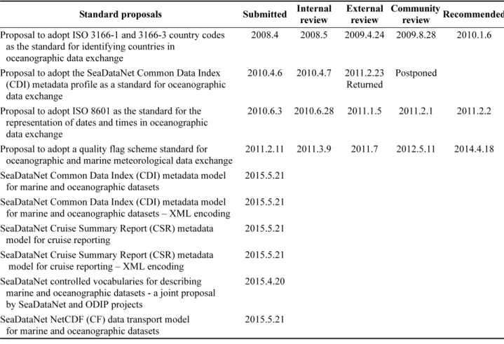
IODE와 JCOMM의 공동 프로젝트인 ODSBP에는 현재 까지 10개의 표준안이 제안되었으며, 이 중에서 3개의 표 준안이 채택되었다(Table 3). ODSBP에서는 2010년에 국 가코드에 대한 표준으로 ISO 3166-1과 3166-3을 채택하 였으며(UNESCO 2010), 2011년에는 날짜/시간 표현에 대 한 표준으로 ISO 8601을 채택하였다(UNESCO 2011).
2013년에는 자료의 품질관리결과를 나타내는 품질표식 (quality flag)의 국제표준을 채택하였는데, 1차 표식 (primary level flag) 와 2차 표식(secondary level flag)로 구 성되어 있다(UNESCO 2013). 한편, 유럽의 SeaDataNet에 서는 자체 메타데이터 표준을 국제 표준으로 2010년에 제 안하였으나, 여전히 전문가 검토과정 중에 있다. SeaDataNet 은 2015년 4월에 SeaDataNet의 표준용어를 국제표준으로 제안하였고, 5월에는 Cruise Summary Report 등 5가지 표준을 추가로 제안하였다. 현재까지 ODSBP에서 채택한
Table 3. Submitted standard proposals to IODE ODSBP (ODSBP 2015) Standard proposals Submitted Internal
review
External review
Community
review Recommended Proposal to adopt ISO 3166-1 and 3166-3 country codes
as the standard for identifying countries in oceanographic data exchange
2008.4 2008.5 2009.4.24 2009.8.28 2010.1.6
Proposal to adopt the SeaDataNet Common Data Index (CDI) metadata profile as a standard for oceanographic data exchange
2010.4.6 2010.4.7 2011.2.23 Returned
Postponed
Proposal to adopt ISO 8601 as the standard for the representation of dates and times in oceanographic data exchange
2010.6.3 2010.6.28 2011.1.5 2011.2.1 2011.2.2
Proposal to adopt a quality flag scheme standard for oceanographic and marine meteorological data exchange
2011.2.11 2011.3.9 2011.7 2012.5.11 2014.4.18 SeaDataNet Common Data Index (CDI) metadata model
for marine and oceanographic datasets
2015.5.21 SeaDataNet Common Data Index (CDI) metadata model
for marine and oceanographic datasets – XML encoding
2015.5.21 SeaDataNet Cruise Summary Report (CSR) metadata
model for cruise reporting
2015.5.21 SeaDataNet Cruise Summary Report (CSR) metadata
model for cruise reporting – XML encoding
2015.5.21 SeaDataNet controlled vocabularies for describing
marine and oceanographic datasets - a joint proposal by SeaDataNet and ODIP projects
2015.4.20
SeaDataNet NetCDF (CF) data transport model for marine and oceanographic datasets
2015.5.21
국제표준들은 코드체계에서 활용 가능한 것으로, 동일한 내용을 다루는 경우에 그대로 사용할 수 있다.
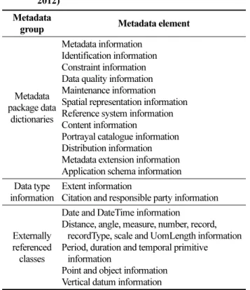
SeaDataNet은 유럽 35개 국가의 44개 해양자료센터가 참여하고 있는 분산네트워크 시스템으로, 여러 자료센터 에서 운영하는 DB 시스템을 일괄 검색하는 서비스를 제 공하고 있다. SeaDataNet CDI(Common Data Index)를 통해 메타데이터 통합 검색이 가능하며, 검색된 자료는 각 자료센터에서 직접 제공하는 방식을 취하고 있다. 여러 기 관의 DB를 통합 검색하는 만큼 표준화된 메타데이터를 일관되게 유지해야 하므로, 메타데이터 표준 수립에 많은 노력을 투입하였다. 우선적으로 사용하는 용어에 대한 표 준화를 수행하였으며, 메타데이터 검증 프로그램을 개발 하여 메타데이터를 제공하는 기관에서 활용하도록 하고 있다. SeaDataNet 메타데이터 프로파일은 기본적으로 ISO 19115 의 메타데이터 요소들을 도입하면서, 일부 요소 들에 대한 세부조건을 변경하여 활용하고 있다. SeaDataNet 의 메타데이터 요소들은 자료세트별 유통을 위한 항목들 로 Table 4와 같으며, 자료정의, 품질정보, 유지보수, 공간 정보, 자료내용 등에 대한 메타데이터들로 구성되어 있 다. 각 메타데이터는 다수의 세부 메타데이터들로 구성되 어 있는데, 세부 메타데이터가 총 400개를 넘어서 모든 요 소들이 실제 활용될 가능성은 많지 않다. 연구사업을 수행 하는 연구자 입장에서는 지나치게 많은 내용을 준비하여
야 하므로, 이번에 도출하는 표준(안)에서 그대로 인용할 수 없다.
ISO는 국제 표준화 기구로 1947년에 설립된 비정부조 직이며, ISO 표준은 자발적(Voluntary) 표준으로 법적인 구속력은 없으나, ISO 표준을 따르지 않을 경우 국제적인 교류에서 불편을 겪을 수 있다. 이런 이유로 대부분의 ISO 회원국들이 ISO 표준을 그대로 따르거나 ISO 국제 표준에 기반 한 국가 표준을 수립하는 추세이다. 해양관련 지리정보 메타데이터는 ISO 19100 시리즈 프로파일을 기 준으로 하고 있으며, SeaDataNet과 국제수로기구(IHO, International Hydrographic Organization) 에서는 메타데이 터 표준 수립과정에서 ISO 19115 스키마를 활용하고 있 다. ISO 19115는 기본적으로 지리정보 표준이므로 해양자 료를 지도상에 표시하기 위한 정보를 기본적으로 다루고 있으며, 자료 자체에 대한 상세정보는 속성정보로 처리한 다. 해양자료관리에 활용 가능한 메타데이터 항목은 SeaDataNet 표준(Table 4)과 동일하며, ISO 19115 문서는 Fig. 4 와 같은 포맷으로 각 세부 메타데이터별 이름, 설명, 필수항목 여부, 최대 출현회수, 자료형태 등을 상세하게 기술하고 있다. 본 연구를 통해 도출한 표준(안)을 문서화 하는 과정에서 ISO19115의 표현양식을 이용하였다.
해양물리자료 표준
해양물리자료는 국내외적으로 가장 널리 사용되는 해양 자료이므로, 오래 전부터 여러 해양기관에서 체계적으로 수집, 관리하였으며, 자체적인 자료저장 서식이나 표준 포 맷 등을 만들어 사용하고 있다. 최근에는 새로운 관측방법 이 개발되면, 국제적인 표준화 작업을 동시에 추진하는 경 향이 있다.
미국 NCEI
1)(National Center for Environmental Table 4. Metadata elements of SeaDataNet metadata profile
introduced from ISO 19115 (Boldrini and Nativi 2012)
Metadata
group Metadata element
Metadata package data
dictionaries
Metadata information Identification information Constraint information Data quality information Maintenance information Spatial representation information Reference system information Content information
Portrayal catalogue information Distribution information Metadata extension information Application schema information Data type
information
Extent information
Citation and responsible party information
Externally referenced
classes
Date and DateTime information
Distance, angle, measure, number, record, recordType, scale and UomLength information Period, duration and temporal primitive
information
Point and object information Vertical datum information
Fig. 4. Metadata description format used in ISO 19115 document (ISO 2003)
1)
NCEI: 미국 NCDC(National Climate Data Center),
NODC(National Oceanographic Data Center), NGDC(National
Geographic Data Center) 의 통합기관, 2015년 4월 발족
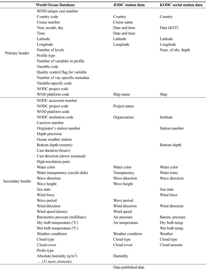
Table 5. Metadata comparison among WOD, JODC and KODC (NODC 2013, JODC 2015, KODC 2015) World Ocean Database JODC station data KODC serial station data
Primary header
WOD unique cast number
Country code Country Country
Cruise number Cruise name
Year, month, day Date and time Date (KST)
Time Date and time
Latitude Latitude Latitude
Longitude Longitude Longitude
Number of levels Num. of obs. depth
Profile type
Number of variables in profile Variable code
Quality control flag for variable Number of var,-specific metadata Variable-specific code
NODC project code
WOD platform code Ship name Ship
Secondary header
NODC accession number
NODC project code Project name WOD platform code
NODC institution code Organization Institute Cast/tow number
Originator’s station number Station number Depth precision
Ocean weather station
Bottom depth (meters) Bottom depth
Cast duration (hours)
Cast direction (down assumed) High-resolution pairs
Water color Water color Water color
Water transparency (secchi disk) Transparency Water trans.
Wave direction Wave direction Wave direction
Wave height Wave height
Sea state Sea state
Wind force Wind force
Wave period Wave period
Wind direction Wind direction Wind direction Wind speed (knots) Wind speed
Barometric pressure (millibars) Air pressure Barom. pressure Dry bulb temperature (
oC) Air temperature Dry bulb temp.
Wet bulb temperature (
oC) Wet bulb temp.
Weather conditions Weather condition Weather
Cloud type Cloud type Cloud type
Cloud cover Cloud cover Cloud amount
Probe type
Absolute humidity (g/m
3) Humidity
… (31 more elements)
Data published date
Line number
Information) 는 해양 분야 세계자료센터 역할을 수행하면 서 IODE Data Center Network을 통해 전 세계 해양물리 자료를 수집하고 있으며, WOD 형태의 데이터세트로 구 성하여 해양학계에 배포하고 있다. WOD는 1993년에 첫 번째 버전이 만들어 졌으며, 가장 최신버전은 2013년에 배포되었다. 기본적으로 수온, 염분자료가 중심을 이루고 있으나, 화학자료나 생물자료도 일부 포함되어 있다. 전 세계에서 매우 다양한 관측방법으로 생산하는 해양자료를 통합관리하고 있으며, 해양학자들이 필요한 부가정보를 같이 제공하기 위해 관측자료에 메타데이터를 헤더형태로 추가하고 있다. 더불어 각 자료에 대한 품질정보, 유효자 리 정보를 제공하고 있으며, 중복적으로 출현하는 정보를 관리하기 위한 다수의 코드체계를 운영하고 있다. WOD 의 1차 헤더에서 각 관측에 대한 항해번호, 날짜, 시간, 장 소, 자료수, 자료항목 수 등의 정보를 담고 있으며, 2차 헤 더는 기상정보를 비롯한 추가 정보들을 다루고 있다. 일본 해양자료센터(JODC)는 IODE 자료센터 네트워크에서 일 본의 국가자료센터 역할을 수행하고 있다. 일본에서 생산
되는 해양물리, 해양화학, 해양생물, 해양지질 분야 자료 를 수집, 관리하고 있으며, 인터넷 정보서비스를 통해 자 료를 해양학계에 제공하고 있다. JODC에서 운영하는 메 타데이터 항목은 기본적으로 WOD의 메타데이터와 유사 하다. 국립수산과학원(NFRDI)에서는 동해, 남해, 황해에 서 격월간으로 정선관측을 수행하고 있으며, 수집한 자료 는 KODC(Korea Oceanographic Data Center) 자체 포맷 으로 배포하고 있다. KODC에서 배포하는 자료파일에는 관측자료와 함께 관련 메타데이터를 헤더 형태로 제공하 고 있으며, WOD 포맷을 많이 따르고 있다. WOD, JODC 정점자료, KODC 정선관측자료의 메타데이터 항목들을 비교하면 Table 5와 같다. 관측과 관련된 기본 정보(위치, 시간, 선박 등)과 일부 부가정보(기상, 파도)는 모든 자료 포맷에 포함되어 있으며, 품질정보, 캐스팅방향, 수심 정 밀도 등은 WOD에만 포함하고 있다. 정점관측 자료의 관 리에 필요한 기본적인 메타데이터들은 대부분 포함되어 있으나, 연구사업과 항해에 대한 상세정보가 충분히 포함 되어 있지 않다.
Table 6. WOCE metadata of Shipboard ADCP (JASADCP 2012)
Group Metadata
Header information (1)
Cruise details
- Platform (ship)
- Port to port date/time ranges - Port to port position ranges
- Chief scientist and affiliation at time of the cruise
- SADCP PI/agency responsible for the overseeing the casts - Project title
- Secondary project title
Cruise identification
- Originator’s cruise ID
- Cruise ID given by ship management - Project ID-1
- Project ID-2
- SADCP data center ID
Profile specifics
- Profile identification
Originator’s station ID and cast ID Project station ID and cast ID SADCP data center profile ID - Profile date/time range
Year base: yyyy
Start, bottom, and end ship time for SADCP calculation CTD bottom time (YYYYMMDDHHMMSS.s) - Profile position
Start to end latitude positions (−90 to 90) Start to end longitude positions (0 to 360)
Header information (2)
Barotropic tide as u, v (m/sec), model type (ASCII string, fixed options) Ocean depth (m)
Maximum cast depth (m) Magnetic deviation (deg)
Navigation type (ASCII string, fixed options: GPS, DGPS, GLONASS, non-conventional)
NCEI 로 통합되기 이전의 NODC와 NCDDC(National Coastal Data Development Center) 는 하와이 대학의 ADCP 연구실과 함께 JASADCP(Joint Archive of Shipboard ADCP) 와 JALADCP(Joint Archive of Lowered ADCP)를 구축하였다. JASADCP와 JALADCP는 일본해양자료센터 (JODC, Japan Oceanographic Data Center)와 공동으로 ADCP의 WOCE 자료취합센터(WOCE Data Assembly Center) 를 운영하였다. WOCE 자료취합센터는 Shipboard ADCP 와 Lowered ADCP의 자료 관리를 위한 메타데이터 항목과 자료유통 포맷을 제시하고 있다. Shipboard ADCP 의 메타데이터 항목은 Table 6과 같으며, ADCP 관측자료 는 netCDF 포맷과 ASCII 포맷으로 관리하고 있다. 기본
적으로 ADCP 자료를 관리하는데 필요한 메타데이터와 자료포맷을 모두 제시하고 있어서, 자료 자체의 관리에 는 충분하지만, 본 연구에서 활용하기 위해서는 연구사 업 관련정보와 관측정보의 메타데이터를 추가할 필요가 있다.
한국해양과학기술원(KIOST)에서는 연구사업 수행과정 에서 생산한 자료의 통합 관리를 위한 자료관리시스템을 구축하였으며, 데이터베이스 시스템을 이용하여 자료를 관리하고 있다. 해양물리, 해양화학, 해양생물, 해양지질 자료의 체계적 관리를 위해 메타데이터와 코드체계를 정 비하였으며, 이를 모두 저장·관리할 수 있는 데이터베이 스를 구축하였다. 한국해양과학기술원의 모든 자료는 연 구사업을 통해 생산되는 만큼 연구사업명, 연구책임자, 사업기간 등의 사업관련 정보를 기본적으로 다루고 있다.
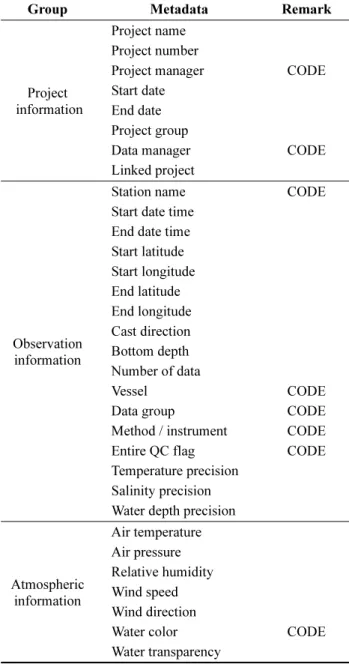
CTD 메타데이터와 자료포맷은 WOD, GTSPP(Global Temperature Salinity Profile Program), ARGO(Array for Real-time Geostrophic Oceanography) 자료포맷을 참고하 여 만들었으며, 전체 프로파일에 대한 QC 정보, 수심, 수 온, 염분의 정밀도 정보, 측정방향, 선박정보 등과 함께 각 수심에서의 각 자료항목의 품질정보를 관리하고 있다.
CTD 자료의 메타데이터 항목은 Table 7과 같으며 이번 표준(안) 도출에서 가장 많이 활용하였다.
4. 해양자료 표준(안)
이번에 도출한 표준(안)에서는 메타데이터 항목, 코드체 계, 자료포맷에 대한 표준을 제시하였다. 메타데이터는 모 든 자료항목에 동일하게 적용되는 공통 메타데이터와 자 료항목별로 적용되는 메타데이터로 구성하였으며, 코드체 계는 공통코드와 연구분야별 코드체계로 구성하였다(Fig.
5). 자료포맷은 자료항목별로 표준(안)을 제시하였다.
표준(안) 도출과정에서 기존 국내외 표준을 참고하였으 며, 전체적으로 한국해양과학기술원 메타데이터 구성을 기반으로 전체 구조를 설계하고 각 자료항목별로 필요한 메타데이터 요소들을 추가하는 방식으로 진행하였다. 공 통항목 표준(안) 도출과정에서는 해양수산부 연구사업 진 행과 관련된 정보를 다루는 항목들을 대폭 추가하였다. 기 Table 7. Metadata of KIOST CTD data (KORDI 2011)
Group Metadata Remark
Project information
Project name Project number
Project manager CODE Start date
End date Project group
Data manager CODE Linked project
Observation information
Station name CODE Start date time
End date time Start latitude Start longitude End latitude End longitude Cast direction Bottom depth Number of data
Vessel CODE
Data group CODE
Method / instrument CODE Entire QC flag CODE Temperature precision
Salinity precision Water depth precision
Atmospheric information
Air temperature Air pressure Relative humidity Wind speed Wind direction
Water color CODE
Water transparency
Fig. 5. Components of suggested standards for research
data management
존 KIOST에서 다루던 1년 단위의 사업정보와 더불어, 장 기적으로 단계별로 운영되는 연구프로그램에 대한 정보를 포함하는 메타데이터 항목들을 추가하였다. 항해에 대한 메타데이터 항목에서는 항해 총괄책임자와 자료별 관측책 임자를 구분하여 관리할 수 있도록 하였으며, SeaDataNet 메타데이터에서 다루는 자료책임자, 시간, 위치등의 기본 정보들도 포함시켰다. 자료항목별 표준(안) 도출과정에서 는 각 항목별로 기존에 널리 사용되는 표준을 기준으로 다른 표준의 내용을 추가하는 방식을 적용하였다. CTD와 시계열 자료의 표준(안) 도출에는 KIOST 메타데이터와 NODC, KODC 의 표준포맷을 이용하였는데, 추가적으로 부착된 센서에서 생산하는 관측자료와 품질정보를 모두 관리할 수 있도록 하였다. ADCP 자료의 주요 메타데이터 와 자료포맷은 기본적으로 WOCE 기준을 준용하였는데, 관측장비의 설정상태, 자료처리 프로그램 등을 메타데이 터에 포함시켰다. 또한, 중복된 값이 자주 발생하는 메타 데이터들을 다루기 위하여 가능한 많은 코드체계를 도입 하였으며, 국제적으로 통용되는 표준이 있는 경우에는 그 대로 활용하였다. 도출한 표준(안)의 문서화에는 ISO 19115 의 양식(Fig. 4)을 이용하여 자체 양식을 만들었으며, 각 항목의 필수 여부, 다수 출현 여부, 코드 활용에 대한 내용을 포함하고 있다(Table 8, 11, 14).
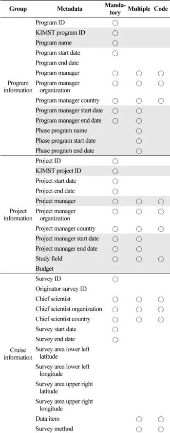
공통항목 표준(안)
모든 자료항목에 동일하게 적용할 수 있는 메타데이터 와 코드체계로 공통항목 표준(안)을 구성하였다. 공통 메 타데이터 요소들은 연구프로그램 정보, 연구사업 정보, 항 해정보로 구분할 수 있다(Table 8). 장기간 진행되는 연구 프로그램의 단계 구분, 연구책임자 변경 사항 등을 연구프 로그램 메타데이터에서 관리하며, 1년 단위 연구사업과 관련된 한국해양과학기술진흥원 관리번호, 연구책임자, 예산 등은 연구사업 메타데이터에서 관리한다. 항해 메타 데이터에서는 책임과학자, 탐사영역, 자료항목 등에 대한 정보를 다루고 있다. 각 메타데이터에 대한 설명은 Table 8 과 같이 문서화하였으며, 필수 항목인 경우는 mandatory 컬럼에, 자료가 여러 개 발생할 수 있는 경우는 multiple 컬럼에, 반복되는 값으로 code 활용이 필요한 경우는 code 컬럼에 표기하였다.
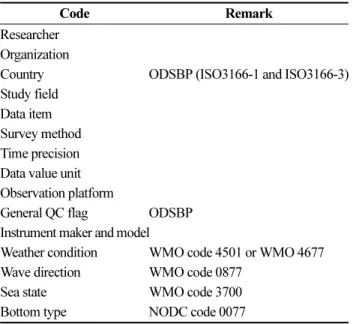
공통항목 메타데이터 중에서 연구기관명, 연구책임자 이름, 자료 단위, 관측기기 등 중복된 값이 자주 발생하는 항목은 코드체계를 도입하였다(Table 9). 이를 통해 자료 오류를 최소화하고, 데이터 무결성을 보장할 수 있다. 코 드들 중에서 국제표준이 있는 경우 이를 사용하도록 하였 으며, 새로운 정보들을 계속 추가해야 하는 코드들은 자체 적으로 코드를 생산하도록 하였다. 각 코드에 대한 상세한
Table 8. List of common metadata elements (gray background cells indicate newly added or modified elements in this study)
Group Metadata Manda-
tory Multiple Code
Program information
Program ID ○
KIMST program ID ○
Program name ○
Program start date ○ Program end date
Program manager ○ ○ ○
Program manager
organization ○ ○ ○
Program manager country ○ ○ ○ Program manager start date ○ ○ Program manager end date ○ ○
Phase program name ○
Phase program start date ○ Phase program end date ○
Project information
Project ID ○
KIMST project ID ○
Project start date ○
Project end date ○
Project manager ○ ○ ○
Project manager
organization ○ ○ ○
Project manager country ○ ○ ○ Project manager start date ○ ○ Project manager end date ○ ○
Study field ○ ○ ○
Budget
Cruise information
Survey ID ○
Originator survey ID
Chief scientist ○ ○ ○
Chief scientist organization ○ ○ ○ Chief scientist country ○ ○ ○ Survey start date ○
Survey end date ○
Survey area lower left latitude
Survey area lower left longitude
Survey area upper right latitude
Survey area upper right longitude
Data item ○ ○
Survey method ○ ○
설명은 Table 10과 같은 양식으로 문서화 하였으며, 각 코드요소들의 필수 여부와 다른 코드 활용 여부를 명시 하였다.
해양물리자료 표준(안)
해양물리자료 중에서 CTD, SADCP, LADCP, 시계열 자료에 대한 메타데이터, 데이터포맷, 코드체계에 대한 표준(안)을 도출하였다. CTD 자료에 대한 메타데이터는 관측정보, 자료항목정보, 부가정보로 구성하였으며, 각 메타데이터 요소의 필수 여부, 다수 여부, 코드 활용 여부 를 문서화하였다(Table 11). 관측정보 메타데이터로는 관 측일시, 위치, CTD 캐스팅 방향 등이 있으며, 선박을 이 용한 항해정보는 공통항목의 메타데이터와 연계하도록 하였다. 자료항목 정보는 자료항목, 단위, 정밀도, 관측책 임자 등에 대한 메타데이터로 구성하였으며, 부가정보는 투명도, 파랑, 기온, 바람 등에 대한 메타데이터들로 구 성하였다. 부가정보는 KIOST, WOD, KODC에서 공통 적으로 다루는 항목들을 포함시켰으며, 관측자의 주관적 인 견해가 포함되는 구름형태, 구름분포 등의 정보는 제 외하였다.
Table 10. Example of a code for common metadata (researcher code)
Code elements Description Mandatory Code
Researcher ID Unique researcher identifier ○
Researcher name Name of researcher ○
Researcher organization Institute of researcher ○ ○
Researcher country Nationality of researcher ○ ○
Academic degree Academic degree ○
Study area Major/interesting study area
Table 11. List of metadata elements for CTD
Group Metadata Manda-
tory Multiple Code
Observation information
Cast ID ○
Originator cast ID
Date ○
Time ○
Time precision ○ ○
Latitude ○
Latitude precision ○
Longitude ○
Longitude precision ○ End date
End time
Time precision ○
End latitude End latitude precision End longitude End longitude precision Number of level
Profile type ○
Cast direction ○ ○
Data item information
Number of data item ○
Data item ○ ○ ○
Data value unit ○ ○ ○
Data value precision ○
Entire cast QC flag ○
Principal investigator ○ ○ ○
Principal investigator
organization ○ ○ ○
Principal investigator country ○ ○ ○
Observation platform ○
CTD instrument ○ ○
CTD instrument calibration ○
Auxiliary information
Weather condition ○
Transparency
Wave direction ○
Wave height
Sea state ○
Air pressure Air temperature Wind speed Wind direction Table 9. Code list for common metadata
Code Remark
Researcher Organization
Country ODSBP (ISO3166-1 and ISO3166-3) Study field
Data item Survey method Time precision Data value unit Observation platform
General QC flag ODSBP Instrument maker and model
Weather condition WMO code 4501 or WMO 4677 Wave direction WMO code 0877
Sea state WMO code 3700
Bottom type NODC code 0077
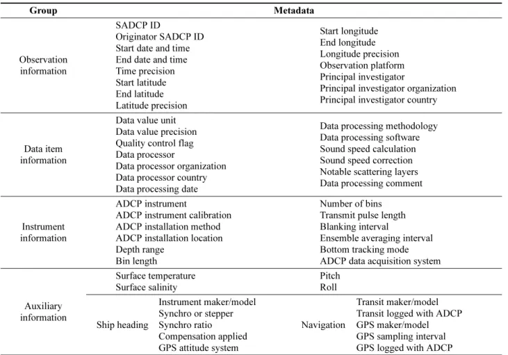
Table 12. List of metadata elements for SADCP
Group Metadata
Observation information
SADCP ID
Originator SADCP ID Start date and time End date and time Time precision Start latitude End latitude Latitude precision
Start longitude End longitude Longitude precision Observation platform Principal investigator
Principal investigator organization Principal investigator country
Data item information
Data value unit Data value precision Quality control flag Data processor
Data processor organization Data processor country Data processing date
Data processing methodology Data processing software Sound speed calculation Sound speed correction Notable scattering layers Data processing comment
Instrument information
ADCP instrument
ADCP instrument calibration ADCP installation method ADCP installation location Depth range
Bin length
Number of bins Transmit pulse length Blanking interval
Ensemble averaging interval Bottom tracking mode ADCP data acquisition system
Auxiliary information
Surface temperature Surface salinity
Pitch Roll
Ship heading
Instrument maker/model Synchro or stepper Synchro ratio
Compensation applied GPS attitude system
Navigation
Transit maker/model Transit logged with ADCP GPS maker/model GPS sampling interval GPS logged with ADCP
SADCP 자료에 대한 메타데이터는 관측정보, 자료항목 정보, 장비정보, 부가정보로 구성하였다(Table 12). 자료항 목 정보에는 단위, 품질표식, 자료처리방법에 대한 메타데 이터들을, 기기정보에는 ADCP 장비 종류, 선박에서의 부 착방법, 빈(bin) 관련 정보, 자료수집시스템 등에 대한 메 타데이터들을 포함하였다. 선박에 부착된 ADCP는 선박 의 움직임에 따라 자료에 오류가 발생할 수 있으므로, ADCP 자료처리에 반드시 필요한 선박상태정보인 Pitch, Roll, Ship Heading, Navigation을 부가정보로 메타데이터 에 포함하였다. LADCP 자료의 메타데이터에는 하향 ADCP 와 상향 ADCP 기기에 대한 메타데이터들과 함께, 자료처리에 필요한 SADCP 자료, CTD 자료에 대한 메 타데이터들이 포함되어 있다(Table 13). ADCP 자료의 메타데이터에 대한 자세한 내용은 표준(안) 문서에 기술 하였다.
연속관측 시계열 자료의 메타데이터에는 기본적인 정점 관측 메타데이터에 시작시각, 종료시각, 관측간격, 관측장 비 설치 등에 대한 메타데이터를 추가하였다(Table 14).
연속관측에서는 시간 경과에 따라 관측수심과 기상상태가
변하므로 메타데이터에는 이를 포함시키지 않았다. 대신, 자료에 관측시간과 관측수심을 저장하도록 자료포맷을 제 시하였으며, 기상정보도 필요에 따라 자료에 추가할 수 있 도록 구성하였다.
이번에 도출한 표준(안)에서는 4가지 자료항목에 대한 데이터포맷 표준(안)도 제시하였다. 일반적으로 많이 사용 하는 ASCII 포맷 표준(안)을 제시하였으며, 각 수심에서 의 자료별 품질정보를 포함하도록 하였다. 자료포맷에 대 한 설명에는 메타데이터와 동일한 형식의 문서양식을 이 용하였다(Table 15). ADCP 자료의 경우에는 ASCII 포맷 과 함께 netCDF 포맷 표준(안)을 제시하였으며, netCDF 에 대한 CDL(Common Data Language)을 제공하였다 (Table 16).
해양물리자료 메타데이터에 대한 코드 목록은 Table 17
과 같으며, CTD 프로파일, 캐스팅, 품질표식, 장비, ADCP
장비, 구성, 자료수집 시스템, 자료처리방법 등을 코드로
관리하도록 하였다. 모든 자료항목에서 같이 사용할 수 있
는 국가, 연구책임자 등의 코드는 공통항목에서 제시한 코
드를 사용하면 된다.
Table 13. List of metadata elements for LADCP
Group Metadata
Observation information
LADCP cast ID
Originator LADCP cast ID Start date and time Bottom date and time End date and time Time precision Start latitude End latitude Latitude precision Start longitude
End longitude Longitude precision Ocean depth Profile max depth Magnetic deviation Observation platform Principal investigator
Principal investigator organization Principal investigator country
Data item information
Data value unit Data value precision Quality control flag Data processor
Data processor organization Data processor country Data processing date
Data processing methodology Data processing software Sound speed calculation
Depth calculation
Percent of 3 beam solution Data processing comment Barotropic velocity reference Barotropic U velocity Barotropic V velocity Barotropic velocity error Barotropic tide model Barotropic tide U velocity Barotropic tide V velocity
Instrument information
Downward looking instrument
ADCP instrument ADCP calibration Bin length Number of bins Transmit pulse length Blanking interval Ping staggered
Ping transmission interval Number of pings
Velocity ambiguity Single ping accuracy Coordinate system Bottom tracking mode Comments
Upward looking instrument
ADCP instrument ADCP calibration Bin length Number of bins Transmit pulse length Blanking interval Ping staggered
Ping transmission interval Number of pings
Velocity ambiguity Single ping accuracy Coordinate system Comments
Auxiliary information
SADCP profile data Pegasus profile data Bottom track profile
Navigation time series CTD time series
5. 결론 및 토의
연구사업 해양자료의 공동 활용을 목적으로 자료 관리 를 위한 표준화작업을 수행하였다. 표준화를 위한 자체 절 차를 수립하였고, 절차에 따라 국내외 해양자료표준 분석, 표준안 도출, 전문가 검토, 학계 검토 과정을 거쳐 총 125 쪽의 표준(안) 문서를 작성하였다. 이 과정에서 한국해양 과학기술원을 비롯하여 WOD, WOCE, KODC, SeaDataNet, ISO19115의 표준을 이용하여 연구사업 자료관리를 위한 메타데이터, 코드체계, 자료포맷에 대한 표준안을 만들었 다. 공통항목 표준(안)에서는 장기 연구프로그램과 1년 단 위 연구사업의 모든 정보를 관리할 수 있는 메타데이터
항목들을 추가하였으며, 연구진행중에 발생하는 변경사항 들도 관리할 수 있는 코드체계를 도입하였다. 자료항목별 표준(안)에서는 각 관측자료 정밀도와 수심별 자료의 품질 정보를 관리할 수 있도록 함으로써, 여러 사업에서 생산하 는 해양자료의 신뢰성 확보에 노력하였다.
여기서 제시한 표준(안)은 기본적으로 해양자료의 생산 특성을 반영한 자료관리에 초점을 맞추고 있으므로, 국제 표준 후보인 SeaDataNet 메타데이터 프로파일이나 지리 정보 표준인 ISO 19115와 직접 호환되지는 않는다.
SeaDataNet 표준과 ISO 19115는 가공된 데이터세트의 유
통을 위한 표준이며, 그 내용이 매우 복잡하고 XML
(extensible markup language) 활용이 필요하므로, 해양연
구자들이 바로 사용하기에는 어려운 점이 많다. 따라서 해 양연구자들에게 중요한 자료생산관련 정보에 중점을 두 고, 정보처리도 용이한 형태로 표준(안)을 만들었다. 꼭 필 요한 정보는 모두 포함하도록 노력하였으며, 변환프로그 램을 작성하여 자료유통에 사용하면, 국제표준과의 상호 Table 14. List of metadata elements for serial data
Group Metadata Manda-
tory Multiple Code
Observation information
Cast ID ○
Originator cast ID
Start date ○
Start time ○
Time precision ○ ○
Latitude ○
Latitude precision ○
Longitude ○
Longitude precision ○ End date
End time
Time precision ○
End latitude End latitude precision End longitude End longitude precision Water depth
Bottom type ○
Data item information
Number of data item ○ ○
Data item ○ ○ ○
Data interval ○
Data value unit ○ ○ ○
Data value precision ○
Quality control flag ○ ○
Principal investigator ○ ○ ○ Principal investigator
organization ○ ○ ○
Principal investigator
country ○ ○ ○
Observation platform ○
Observation instrument ○ ○
Observation instrument
calibration ○
Table 15. Example of description of ASCII data format (CTD)
Data Item Remark Manda-
tory Multiple Code
Depth Observation depth ○ ○
Depth QC QC flag for depth ○ ○
Temperature Water temperature ○ ○ Temperature
QC
QC flag for water
temperature ○ ○
Salinity Salinity ○ ○
Salinity QC QC flag for salinity ○ ○
DO Dissolved oxygen ○
DO QC QC flag for
dissolved oxygen ○ ○
… … (additional data
item) ○
… QC … (QC flag for
additional item) ○ ○
Table 16. Example of netCDF data file (shipboard ADCP) netcdf sadcp {
dimensions:
time = 178 ; // Number of ensembles lat = 100 ; // a geographical location lon = 100 ; // -- " --
depth = 64 ; // velocities were sampled at 64 depth variables:
long time(time) ;
time:FORTRAN_format = "" ; time:units = "True Julian Day" ; time:type = "UNEVEN" ; float lat(lat) ;
lat:FORTRAN_format = "" ; lat:units = "degree_north" ; lat:type = "EVEN" ; float lon(lon) ;
lon:FORTRAN_format = "" ; lon:units = "degree_west" ; lon:type = "EVEN" ; :
(skip) :
float depth(depth) ;
depth:FORTRAN_format = "" ; depth:units = "m" ;
depth:type = "EVEN" ; float U(time, depth, lat, lon) ;
U:name = "U" ;
U:long_name = "EAST VELOCITY" ; U:generic_name = "u" ;
U:FORTRAN_format = " " ; U:units = "cm s-1" ; float V(time, depth, lat, lon) ;
V:name = "V" ;
V:long_name = "NORTH VELOCITY" ; V:generic_name = "v" ;
V:FORTRAN_format = " " ; V:units = "cm s-1" ; :
(skip) : // global attributes:
:CREATION_DATE = " " ; :CRUISE = " " ;
:INST_TYPE = " " ;
:DATA_TYPE = "ADCP" ;
:WATER_MASS = " " ;
:DATA_CMNT = " " ;
호환성을 확보할 수 있다.
표준(안)의 내용이 많아서, 본 논문에서는 공통항목에 대한 표준(안)과 해양물리 4개 자료항목의 표준(안)에 대 하여만 소개하였다. 본 논문에서 다루지 않은 해양화학, 해양생물, 해양지질 및 지구물리 자료의 표준(안)을 소개 하는 논문도 추가적으로 작성할 계획이다.
이번에 도출한 표준(안)은 추가적인 학문적 검토와 실 제 적용을 통해 문제점을 도출하고 지속적으로 개정할 필 요가 있다. 국내 여러 해양관련 기관의 이해관계를 조절하 면서, 국가표준 수립을 주도할 수 있는 위원회 또는 조직 이 필요한 상황이며, 본 연구결과는 향후 국가표준 도출을
위한 기본 자료로 활용되기를 기대한다.
사 사
이 논문은 해양수산부 재원으로 한국해양과학기술진흥 원의 지원을 받아 수행된 연구입니다(관할해역 해양정보 공동활용 체계구축 연구-해양정보유통 기반기술 개발 및 정책 연구).
참고문헌