INTRODUCTION OF J-OFURO LATENT HEAT FLUX VERSION 2
:Masahisa Kubota1, Hiroyuki Tomita2, Shinsuke iwasaki1, Tsutomu Hihara1 and Ayako Kawatsura1
1School of Marine Science and Technology, Tokai University 3-20-1, Shizu-orido, Shizuoka, Shizuka, JAPAN 424-8610
e-mail; [email protected]
2Institute of Observational Research for Global Change, Japan Agency for Marine and Earth Science Technology, Yokosuka, JAPAN
ABSTRACT
Japanese Ocean Flux Data Sets with Use of Remote Sensing Observations (J-OFURO) includes global ocean surface heat flux data derived from satellite data and are used in many studies related to air-sea interaction. Recently latent heat flux data version 2 was constructed in J-OFURO. In version 2 many points are improved compared with version 1. A bulk algorithm used for estimation of latent heat flux is changed from Kondo (1975) to COASRE 3.0(Fairall et al., 2005). In version 1 we used NCEP reanalysis data (Reynolds and Smith, 1994) as SST data. However, the temporal resolution of the data is weekly and considerably low. Recently there are many kinds of global SST data because we can obtain SST data using a microwave radiometer sensor such as TRMM/MI and Aqua/AMSR-E.
Therefore, we compared many SST products and determined to use Merged satellite and in situ data Global Daily (MGD) SST provided by Japan Meteorological Agency. Since we use wind speed and specific humidity data derived from one DMSP/SSMI sensor in J-OFURO, we obtain two data at most one day. Therefore, there may be large sampling errors for the daily-mean value. In order to escape this problem, multi-satellite data are used in version 2. As a result we could improve temporal resolution from 3-days mean value in version 1 to daily-mean value in version 2.
Also we used an Optimum Interpolation method to estimate wind speed and specific humidity data instead of a simple mean method. Finally the data period is extended to1989-2004.
In this presentation we will introduce latent heat flux data version 2 in J-OFURO and comparison results with other surface latent heat flux data such as GSSTF2 and HOAPS etc. Moreover, we will present validation results by using buoy data.
KEY WORDS: J-OFURO2, LATENT HEAT FLUX, SATELLITE DATA
1. INTRODUCTION
Ocean actively changes heat, water and momentum with atmosphere at ocean surface. The exchanged heat, water and momentum are transported by general ocean and atmospheric circulations with global scale. Since the exchanging and transporting processes play important roles for global climate, estimates of those fluxes between atmosphere and ocean and of those transports by ocean and atmospheric circulations are quite important for understanding the mechanism of global climate. However, it is difficult to globally estimate those fluxes and transports by using in situ observation data such as ship observation data because in situ data are extremely sparse in time and space.
However, we can derive considerably homogeneous data with high resolution using analysis and satellite data.
Therefore, it is considered that analysis and satellite data are suitable for obtaining globally-covered fluxes between ocean and atmosphere.
We constructed ocean surface flux data sets mainly using satellite data. The data set named by Japanese Ocean Flux data sets with Use of Remote sensing Observations (J-OFURO) has been provided for scientists (Kubota et al.,2002). Recently new surface heat
flux products were constructed in J-OFURO as the version 2 (J-OFURO2). In the following, the differences between J-OFURO1 and J-OFURO2 associated with latent heat flux are described in section 2, and the comparison results with buoy data and characteristics of J-OFURO2 latent heat flux are shown in section 3.
Finally some conclusions are given in section 4.
2. DIFFERENCES BETWEEN J-OFURO1 AND J-OFURO2
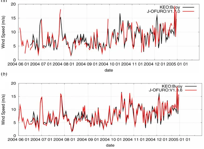
In the version 2 many points are improved compared with the version 1 fro estimation of turbulent heat fluxes. There are three major differences between J-OFURO1 and 2 latent heat flux (LHF). First, multi-satellites data are used in J-OFURO2, while data of only one DMSP Special Sensor Microwave Imager was used for estimation of turbulent heat fluxes. This is based on results from Tomita and Kubota (2007) who demonstrated remarkable reduction of sampling error by using multi-satellite data, in particular in the region of large daily variability. For example, we used all available SSMIs (F08-F15), European Remote-sensing Satellite (ERS) 1/2, QuikSCAT, the Advanced Microwave Scanning Radiometer–EOS (AMSR-E), and the TRMM
Microwave Imager (TMI) for estimation of daily wind speeds. We could recognize that the usage of multi-satellite data is quite effective even if any bias adjustments are not applied for each sensor. On the other hand only available SSMIs (F08-F15) are used for estimation of air specific humidity at present because it is not easy to estimate accurate air specific humidity using AMSR-E and TMI data still now. This is a future issue for J-OFURO3.Many kinds of data are merged by an Optimum Interpolation method (Kako and Kubota, 2006) into daily-mean data with a spatial resolution of 1 degree.
Second, we changed gridded sea surface temperature (SST) data from Reynolds OI SST data (Reynolds and Smith, 1994) to Merged satellite and in-situ data Global Daily (MGD) SST data provided by Japanese Meteorological Agency (JMA). This change is based on results of Iwasaki, Kubota and Tomita (2007) in which intercomparison and evaluation are carried out for five kinds of global SST products. MGD SST was constructed by using infrared SSTs (NOAA/Advanced Very High Resolution Radiometer), Microwave SSTs (Aqua/AMSR-E) and in-situ data (Kurihara et al., 2006).
Next, the bulk formula was also changed from Kondo (1975) to Coupled Ocean-Atmosphere Response Experiment (COARE) bulk algorithm (Version 3.0).
However, warm layer and cool skin effects are not included in J-OFURO2.
The estimation method for sensible heat flux was drastically changed. In J-OFURO1 we used a method proposed by Kubota and Mitsumori (1997) calculating sensible heat flux by multiplying latent heat flux by the climatological Bowen ratio derived from the European Centre for Medium Range Weather Forecasting (ECMWF) data. However, in J-OFURO2 the sensible heat flux is estimated by COARE 3.0 using our merged wind speed, MGD SST data and the National Centers for Environmental Prediction (NCEP)/National Center for Atmospheric Research Reanalysis (NRA1) air temperature data.
Finally the temporal resolution is improved from 3-day mean to daily mean. Also the data period is extended from 1992-2000 to 1988-2005. Radiation data in J-OFURO1 covers the region of the eastern Indian Ocean and the western and central Pacific Ocean between 60°N and 60°S, 80°E and 160°W, because we use only Japanese geostationary satellite for estimation of radiation flux. However, there are many cases for most scientists to need global flux data. Therefore, we provide global net heat flux data estimated by our turbulent heat flux data and the International Satellite Cloud Climatology Project (ISCCP) radiation data in J-OFURO2. However, we estimated the upward longwave radiation using MGD SST data by ourselves.
3.
COMPARISON RESULTS WITH BUOY DATA
We compared J-OFURO2 latent heat flux with in situ latent heat flux data observed by the Kuroshio
Extension Observatory (KEO) buoy. In June 2004, the KEO buoy was deployed in the Kuroshio Extension recirculation gyre at 144.6°E, 32.4°N by NOAA/Pacific Marine Environmental Laboratory (PMEL) to monitor air-sea heat, moisture and momentum fluxes, and upper ocean temperature and salinity. The bias and the Root Mean Square (RMS) error for a daily-mean value of J-OFURO2 latent heat flux are 7 W m–2 and 42 W m–2, respectively. Kubota et al. (2007) showed those values for NRA1 latent heat flux are 38 and 48 W/m2, respectively. Therefore, J-OFURO2 latent heat flux may give us accurate latent heat flux compared with NRA1 latent heat flux.
4. AIR-SEA INTERACTION
. It is famous there exist many warm eddies In the Kuroshio and Kuroshio Extension regions. It is very interesting we can find fine-scaled distribution of latent heat flux associated with that of sea surface anomaly observed by TOPES/POSEIDON altimeter. Such characteristics cannot be found in other latent heat flux fields such as J-OFURO1, OAflux and ECMWF Reanalysis (ERA) 40. The feature suggests ocean plays an active role for atmosphere over the warm eddies. As mentioned before, use of multi-satellite data improves accuracy of turbulent heat fluxes. Moreover, use of multi-satellite data contributes to represent the fine structure of heat fluxes over the Kuroshio/Kuroshio Extension Regions.
5. CONCLUSION
We constructed new surface heat flux products, J-OFURO Version 2. Many points are improved in Version 2 compared with the version 1 fro estimation of turbulent heat fluxes. The temporal resolution is changed from 3-daye mean to daily-mean value. The data period is from 1988 to 2005. While a bulk formula by Kondo(1975) was used in the version 1, COARE 3.0 (Fairall et al., 2003) is used in the version 2. It is most important to use mult-satellite data in the version 2 for estimation of turbulent heat fluxes. We carried out comparison of J-OFURO 2 turbulent heat fluxes with KEO buoy data. Both of the bias and RMS error are small compared with the results with NRA data. It is concluded that use of multi-satellite data can improve accuracy of turbulent heat fluxes. Moreover, it is suggested that J-OFURO 2 latent heat flux may reproduce fine structure of air-sea interaction using multi-satellite data. The J-OFURO2 data can be found at http://dtsv.scc.u-tokai.ac.jp/J-OFURO2.
ACKNOWLEDGMENT:
This study was performed under the Category 7 of MEXT RR2002 Project for Sustainable Coexistence of Human, Nature and the Earth. Also this study was supported by the Japan Aerospace Exploration Agency.
REFERENCES:
Fairall, C. W., E. F. Bradley, J. E. Hare, A. A. Grachev, and J. B. Edson, 2003: Bulk parameterization of
air-sea fluxes: Updates and verification for the COARE algorithm, J. Climate, 16, 571–591.
Iwasaki, S., M. Kubota and H. Tomita, 2007:
Inter-comparison and evaluation of global sea surface temperature products, (submitted to Int. J. Remote Sens.)
Kako, S. and M. Kubota, 2006: Relationship between El Nino event and interannual variability of significant wave height, Atmosphere-Ocean, 44, 377-395.
Kondo, J., 1975: Air-sea bulk transfer coefficients in
diabatic.conditions. Bound. –Layer Meteor., 9, 91-112.
Kubota, M. and S. Mitsumori, 1997: Sensible heat flux estimated by using satellite data over the North Pacific. In: Remote Sensing of Subtropical Ocean, ed. By C.T. Liu, Elsevier,
127-136.
Kubota, M., N. Iwasaka, S. Kizu, M. Konda and K.
Kutsuwada, 2002: Japanese ocean flux data sets with use of remote sensing observations(J-OFURO), J. Oceanogr., 58, 213-225.
Kubota, M., N. Iwabe, M.F. Cronin, and H. Tomita, 2007: Surface heat fluxes fro the NCEP/NCAR and NCEP/DOE reanalyses at the KEO buoy site, J. Geophys. Res. (accepted).
Kurihara, Y., T. Sakurai, and T. Kuragano, 2006: Global daily sea surface temperature
analysis using data from satellite microwave radiometer, satellite infrared radiometer and in-situ observations, Weath. Bulletin, 73, special issue, s1–s18. (in Japanese)
Reynolds, R. W. and T. M. Smith, 1994: Improved global sea surface temperature analyses using optimum interpolation. J. Climate, 7, 929-948.
Tomita, H. and M. Kubota, 2007: Usage of multi- satellite data for estimating accurate daily-mean surface latent heat flux, (submitted to Int. J.
Remote Sens.)
(a)
(b)
Figure 1. Time variation of wind speed data observed by KEO buoy and derived from (a). single satellite (DMSP/SSMI, F10) and (b). multi-satellite ( DMSP/SSMI F13,14 and 15, Aqua/AMSR-E and QSCAT) data.
Figure 2. Time variation of LHF of J-OFURO2 and observed by KEO buoy.
Figure 3, Same figure as Fig,.1 except SHF.
Figure 4. Sea surface height anomaly derived from TOPEX/POSEIDON and latent heat flux by J-OFURO2, OAflux and ERA40 in the Kuroshio and Kuroshio Extension regions.