J. Korea Inst. Build. Constr. Vol. 19, No. 3 : 239-246 / Jun, 2019
https://doi.org/10.5345/JKIBC.2019.19.3.239 www.jkibc.org
3D Point Cloud 기반 4D map 생성을 통한 노후화 시설물 유지 관리 방안
The Maintenance and Management Method of Deteriorated Facilities Using 4D map Based on UAV and 3D Point Cloud
김 용 구
11) 권 종 욱
2*Kim, Yong-Gu
1Kwon, Jong-Wook
2*Integrated PhD program, Graduate School, Yeongnam University, Gyeongsan-si, Gyeongbuk-do, 38541, Korea
1Professor, Department of Architecture, Yeongnam University, Gyeongsan-si, Gyeongbuk-do, 38541, Korea
2Abstract
According to the survey on the status of aged buildings in Korea, A number of concrete buildings deterioration such as houses and apartment buildings has been increased rapidly. To solve this problem, the research related to the facility management, that is one of the importance factor, for monitoring buildings has been increased. The research is divided into Survey-based and Technique-based. However, the problem is that Survey-based research is required a lot of time, money and manpower for management. Also, safety cannot be guaranteed in the case of high-rise buildings. Technique-based research has limitations to applying to the current facility maintenance system, as detailed information of deteriorated facilities is difficult to grasp and errors in accuracy are feared. Therefore, this paper contribute to improve the environment of facility management by 4D maps using UAV, camera and Pix4D mapper program to make 3D model. In addition, it is expected to suggest that residents will be offered easy verification to their buildings deterioration.
Keywords : unmanned aerial vehicle, 3d point cloud, 3d modeling, facility management
1. 서 론
1.1 연구의 배경 및 목적
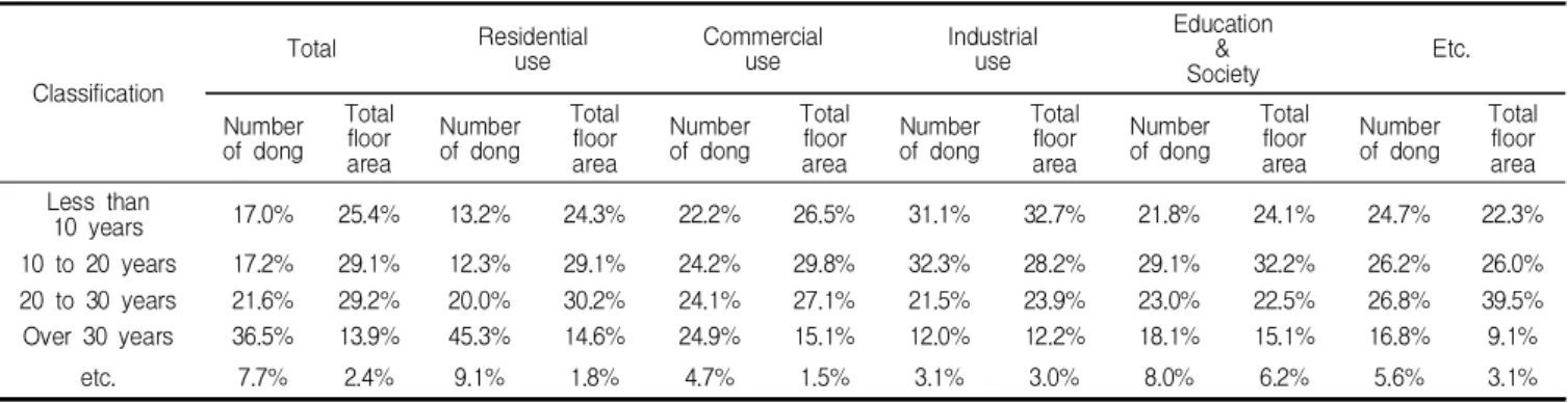
국내 용도별 노후 건축물 현황(Table 1)에 따르면 주거 용, 상업용, 공업용, 문교・사회용 등 여러 용도별 시설물 의 노후화가 급속히 진행되고 있음을 알 수 있다. 특히, 30년 이상 된 건축물은 전국의 36.5%로 전년대비 0.5%
증가하였다[1]. 이에 정부는 노후화 시설물의 안정성 검측
Received : March 19, 2019 Revision received : May 16, 2019 Accepted : May 30, 2019
* Corresponding author : Kwon, Jong-Wook
[Tel: 82-53-810-2438, E-mail: [email protected]]
ⓒ2019 The Korea Institute of Building Construction, All rights reserved.
및 유지관리에 대한 관심을 높이고 있으나 한국의 인프라는 질적인 개선을 이루지 못하고 있으며, 결국 국가 경쟁력 향상에 대한 긍정적 기여 또한 약하다[2].
시설물의 노후화는 우리 사회에 다음과 같은 문제를 초 래한다. 먼저 미관상 시설물의 아름다움을 저해시킬뿐더러 시설물의 내구력을 약화시킨다. 또한 열교현상을 야기 시 켜 건축물의 에너지 손실량을 증가시키는 대표적인 요인 중 하나이다[3]. 앞선 문제를 해결하기 위해 진행되는 시설 물 유지관리 작업은 대부분 검측자가 균열 스케일, 균열 현미경 등의 도구를 이용하여 수작업으로 이루어지고 있 다. 그러나 이는 많은 시간과 인력이 요구되고 검측 과정에 서 주관이 개입될 우려가 있어 검측 결과에 따른 개인차가 발생하는 단점이 있다[4,5]. 또한 기존의 방법은 건물 높이 가 높아질수록 작업자의 안전성을 보장하기 어렵다. 검측
The Maintenance and Management Method of Deteriorated Facilities Using 4D map Based on UAV and 3D Point Cloud
Classification
Total Residential
use Commercial
use Industrial
use
Education
&
Society Etc.
Number of dong
Total floor area
Number of dong
Total floor area
Number of dong
Total floor area
Number of dong
Total floor area
Number of dong
Total floor area
Number of dong
Total floor area Less than
10 years 17.0% 25.4% 13.2% 24.3% 22.2% 26.5% 31.1% 32.7% 21.8% 24.1% 24.7% 22.3%
10 to 20 years 17.2% 29.1% 12.3% 29.1% 24.2% 29.8% 32.3% 28.2% 29.1% 32.2% 26.2% 26.0%
20 to 30 years 21.6% 29.2% 20.0% 30.2% 24.1% 27.1% 21.5% 23.9% 23.0% 22.5% 26.8% 39.5%
Over 30 years 36.5% 13.9% 45.3% 14.6% 24.9% 15.1% 12.0% 12.2% 18.1% 15.1% 16.8% 9.1%
etc. 7.7% 2.4% 9.1% 1.8% 4.7% 1.5% 3.1% 3.0% 8.0% 6.2% 5.6% 3.1%
Table 1. Status of deteriorated facilities used (National Statistical Office, 2017)
자는 리프트 등의 장비들로 시설물 유지관리 작업을 진행하 고 있으나 추락사고와 같은 안전사고로 이어지는 경우가 빈번히 발생하여 작업자의 생명을 위협할 수 있다.
따라서 본 연구는 4차 산업혁명의 핵심 기술인 UAV (Unmanned Aerial Vehicle)의 효과적인 데이터 수집 방 식과 3D Point Cloud를 기반으로 생성되는 3D map에 세 부적인 내용을 추가하여 4D map 시설물 유지관리 방안을 제안하고자 한다. UAV는 무인한공기의 약자로 최근 건설 산업(인프라 점검 및 시공) 중에서 향후 10년간 세계적으로 상업화될 가능성이 가장 높은 분야로 전망하고 있다[6]. 검 측자가 검측할 수 없는 사각지대 영역의 데이터를 획득할 수 있으며, 수작업으로 진행되는 검측 방법보다 빠르므로 작업시간을 단축할 수 있고 검측자를 대신하여 노후 데이터 를 획득할 수 있어 이에 따른 작업비용을 절약할 수 있다.
또한 기존의 글이나 수치만으로 표시된 노후화 정보를 3D Modeling 기법을 통해 시각화함으로써 전문가 혹은 해당지역 주민들이 노후 시설물에 대한 데이터를 쉽게 열람 하고 이해할 수 있다.
1.2 연구의 절차
본 연구의 절차는 Figure 1과 같다. 첫째, 현장답사를 통해 선정된 낙후지역을 조사하여 UAV 영상촬영을 위한 비행경로를 설정한다. 둘째, 선정한 지역의 3D Point Cloud 생성을 위한 시설물의 이미지를 획득한다. 이는 3D model map을 형성하기 위한 기본 데이터로 이용된 다. 셋째, 획득한 이미지의 3D Point Cloud data를 바탕 으로 시설물을 3D modeling 한다. 넷째, 3D model map에 관련 노후화 데이터를 기입하여 4D 지도를 생성 한다. 이는 3D modeling data를 시각화하기 위한 단계 이다.
Figure 1. Research procedure for deteriorated facilities
2. 문헌고찰
한국의 인프라 경쟁력에 대한 순위 상승(2016년도 기준 14위, 2017년도 8위)에도 불구하고 앞선 문제에 대응하는 미국, 영국 등 선진국의 우수한 추진 정책 동향과 달리 한국 은 인프라 부문에서 뚜렷한 차이를 보인다[7].
Table 2에서 보는바와 같이 선진국의 공통적인 정책 방 향은 노후 인프라에 대한 투자를 늘리는 것과 인프라의 자 동화·첨단화를 강조하고 있다.
Nation Content
USA
The "Fixing America's Surface Transport" Act, a national transportation budget, was established in 2015 to provide plans that investing in areas such as roads,
safety, public transportation, railways, R&D approximately $305 billion between the next five years
(2016~2020).
UK
The UK's NIPD plans to invest about 300 billion pounds of its five-year budget in energy, transportation
and social infrastructure.
German
Just like other developed countries, they are increasing their investments in aging infrastructure. In FTIP 2030, maintenance and replacement of existing infrastructure facilities are top priorities, followed by
new infrastructure deployment.
Australia
Emphasizes the need for infrastructure automation and advanced technologies and long-term planning for
infrastructure reconstruction and investment as the environment changes rapidly in the future.
Table 2. Trends in infrastructure implementation
in advanced countries
Type Author Content
Survey- based literature
Park [9]
The maintenance costs of school facilities were analyzed through the data collection
of school facilities maintenance data and survey/ interview survey, and the establishment and utilization of the data
warehouse.
Lee [10]
Measures for safety and maintenance management of port facilities were presented by comparing them with the details of the importance analysis and
satisfaction survey using IPA.
Choi [11]
The management plans for apartments were presented by surveying cases and finding problems through field visits after
analyzing the status.
Jung [12]
The survey was conducted by surveying the management status of apartments and
forming a questionnaire. The difference between importance and performance of the survey was compared through a paired
t-test.
Technique -based literature
Son [13]
The purpose of the Act was to propose a systematic military facility maintenance system by providing the technologies for facility maintenance and periodic facility
maintenance by using drones.
Woo [14]
A safety inspection plan using the aduino and sensor was proposed to investigate
the maintenance status of an aging educational facility and to solve the
problem.
Woo [15]
Using 3D photo scanning and laser scanning technology, 3D modeling was created and used as a base material for
future BIM-based facility maintenance applications.
Kim [16]
For facility inspection, individual images were generated based on images from UAV and DSLR and the accuracy of the images was verified through ground points.
이에 한국은 드론 영상을 기반으로 하여 노후화 시설물 을 점검하는 방법 등 여러 방안을 제시하고 있지만 실질적 으로 시설물 유지관리에 대한 본질적인 문제를 해결하기 어렵고 전문가 이외에는 결과 해석에 대한 어려움이 따른다 [8].
Table 3은 노후화 시설물에 대한 유지관리방안을 조사 를 기반으로 하는 문헌과 기술을 기반으로 하는 문헌으로 나누었다. 조사를 기반으로 하는 노후화 시설물 유지관리 방안은 기초에 근거하는 자료수집과 설문 및 면담을 바탕으 로 법령 혹은 제도에 대해 비판하여 기존의 안전·유지보 수 관리방안의 문제점을 개선하고자 하는 경향이 있다. 기 술을 기반으로 하는 노후화 시설물 유지관리방안은 인간을 대신할 수 있는 장비와 프로그램 혹은 알고리즘 등의 기술 적 요인들을 이용하여 보다 효과적인 안전·유지보수 관리 방안을 제시하는 경향을 보인다.
노후화 척도를 관리자가 직접 수집해야하므로 오랜 시간이 소모되며 유지관리를 위한 인력과 시간이 증가함에 따라 비용 또한 증가하게 된다. 이를 해결하기 위한 기술 기반의 유지관리는 광범위한 노후화 시설물 유지관리 영역을 특정 기술을 통해 단시간에 획득할 수 있으며 추가적인 비용이 발생하지 않는다. 그러나 시설물에 대한 노후화 데이터의 세부적인 내용을 파악하기 어려워 정확성에 대한 오류가 우려되므로 현 시설물 유지관리 시스템에 적용하기에는 제 한적인 부분이 존재한다.
따라서 본 논문은 기존의 제한적인 UAV 촬영기법을 보 완하기 위해서 해당지역의 광역 3D Model 생성을 위한 자동화 UAV 비행촬영기법과 4D map의 시설물 상세내용 을 추가하기 위한 소형 UAV 및 카메라의 국부촬영기법을 도입하였다. 이는 노후화 시설물에 대한 상세 내용을 파악 할 수 있어 현 유지관리 시스템에 적용할 수 있으며 접근성 이 용이해 결과적으로 주민들이 쉽게 이해할 수 있는 기술 기반의 노후화 시설물 유지관리 방안을 제안한다.
3. 연구방법론
3.1 현장조사
Figure 2는 대구광역시 비산 4동, 내당 2, 3동 지역 일대 를 나타낸다.
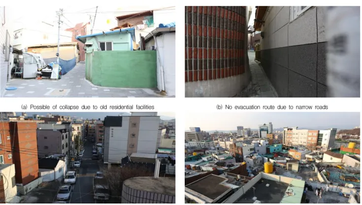
이 지역은 대구광역시의 중심지인 반월당과 주요교통시 설(서문시장역, 청라언덕역[환승역])이 인접해 있음에도 불구하고 낙후된 주거시설로 인한 붕괴 위험성, 좁은 길로 인한 대피경로 미확보, 차량 주차로 인한 소방차량 진입
Figure 2. Bisan 4-dong(飛山洞) & naedang 2, 3-dong(內唐洞)
The Maintenance and Management Method of Deteriorated Facilities Using 4D map Based on UAV and 3D Point Cloud
(a) Possible of collapse due to old residential facilities (b) No evacuation route due to narrow roads
(c) Unable to enter fire truck due to narrow parking space (d) Possible fire transfer due to adjacent buildings Figure 3. Problems in bisan 4-dong(飛山洞) & naedang 2, 3-dong(內唐洞)
불가능, 인접 건물들로 인한 화재 전이 가능성 등의 여러 문제점이 있다(Figure 3).
시설물의 노후화는 리모델링과 재개발 사업과 같은 방법 으로 해결할 수 있으나 일부 주민들의 반대와 사업진행에 소모되는 막대한 예산 등 여러 가지 이유들로 인해 주거환 경은 더욱 악화되고 있다. 앞선 문제를 해결하기 위해서는 노후화 시설 보수 및 유지・관리 방안에 대한 시스템 구축 이 절실하다. 따라서 본 연구는 주민들의 안전을 위해 현실 적 방안을 제시하고 검토하여 문제를 해결하고자 한다.
3.2 노후 시설물 데이터 취득경로 설정
Figure 4는 UAV 비행촬영 영역과 UAV가 이륙·착륙 하는 장소이다. 비산 4동과 내당 2, 3동 중 시설물의 노후 화가 극심하고 기타 여러 문제점을 지니고 있는 지역일대를 비행촬영 영역으로 설정하였다. UAV는 DJI사의 Inspire 2가 이용되었고 비행촬영 시간은 1회에 약 15~20분 소요 되며, 비행촬영 횟수는 총 6번에 걸쳐 진행하였다.
비산 4동과 내당 2, 3동은 경사가 있는 비탈면의 지형이 므로 UAV의 수평비행작업 중 건물에 부딪힐 우려가 발생 할 수 있다. 그러므로 비상시 UAV를 수동으로 제어하기
Figure 4. UAV’s position and flight photography
위해서 지역 일대가 잘 보이는 곳을 UAV의 이・착륙 장소 로 선정하게 되었다.
3.3 노후 시설물 데이터 취득
UAV을 이용하여 노후화 시설물을 촬영하기 위해 사용
Figure 5. Create 3D maps with Pix4D mapper
a) Photography location according to slope b) Deteriorated facilities 3D map in Bisan/Naedang–dong Figure 6. Result of Pix4D mapper project
된 어플리케이션은 DJI GO 4, Pix4D capture이다. DJI GO 4는 DJI의 UAV를 수동으로 조종하기 위한 어플리케 이션이고 Pix4D capture는 DJI 제품을 자동 비행 및 촬영 하기 위해 사용되는 어플리케이션이다. Pix4D capture는 POLYGON, GRID, DOUBLE GRID 등의 비행경로를 선 택하여 지역 일대 및 건물을 다양한 방법으로 비행 및 촬영 할 수 있다. 본 연구에서는 3D models로 이루어진 mapping 작업이 필요하므로 DOUBLE GRID의 비행촬영 경로로 연구를 진행하였다.
3.4 Pix4D mapper를 이용한 3D map 생성
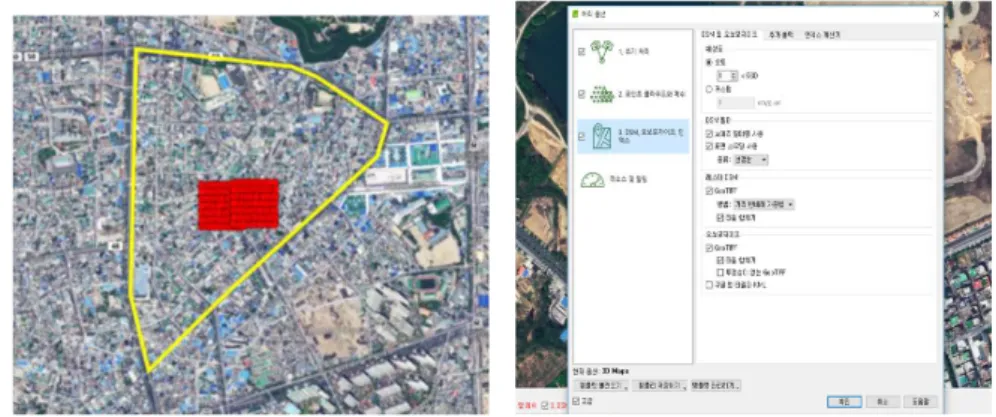
본 연구는 Pix4D mapper를 이용하여 총 822장의 사진 을 3D Modeling 하였다 (Figure 5-a). 촬영영역은 황색 의 선으로 표시된 비산・내당동 내 시설물이며 촬영지점은 적색의 원으로 표시되어 있다 (Figure 5-b). 프로젝트의
단계는 총 3단계로 (1) 초기처리, (2) 포인트 클라우드와 메쉬, (3) DSM, 오쏘모자이크, 인덱스로 구성되어있다 (Figure 5-c). 1단계는 키포인트 이미지 스케일의 크기를 조절할 수 있으며, 품질 보고를 위한 프리뷰를 생성할 수 있다. 2단계는 UAV로 촬영된 영상을 3D Point Cloud로 변환하여 형성된 점들의 집합으로 하나의 Mesh를 생성할 수 있다. 그 밖에 Point Cloud의 이미지 스케일과 포인트 밀도를 조절할 수 있으며 3D 텍스쳐 메쉬 관련 옵션을 선택 할 수 있다. 또한 Pix4D mapper 외 다른 프로그램에 파일 을 호환하기 위해 확장자(LAS, LAZ, PLY, XYZ 등)를 변환하여 새로운 3D Point Cloud 파일을 생성할 수 있다.
3단계는 DSM 및 오쏘모자이크를 생성하기 위한 단계이다.
등고에 따른 높낮이를 색상으로 표현 가능하며 해상도, 필 터 등이 조절 가능하다. 또한 구글 맵과 생성된 프로젝트를 오버랩하여 하나의 지도로 생성할 수 있다.
The Maintenance and Management Method of Deteriorated Facilities Using 4D map Based on UAV and 3D Point Cloud
Figure 7. Add detailed data for 4D map using autodesk recap
3.5 3D map에 객관적 data 기입(4D map 생성)
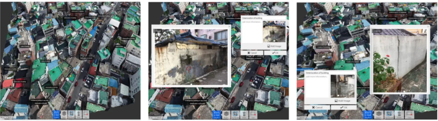
Figure 6은 Pix4D mapper를 통해 생성된 3D map이 다. 비행촬영 위치가 기록된 GPS 정보는 해당지역 일대의 높낮이를 알 수 있다. 또한 비행촬영영상 데이터를 기반으 로 생성된 3D map은 시설물의 노후화 데이터를 시각화함 으로써 전문가의 시설물 유지관리 관련 업무와 주민들의 노후화 시설물에 대한 인식에 용이하게 사용될 수 있다.하지만 인접건물, 주변시설과의 충돌 및 사생활 침해를 방지하기 위해 비행촬영지점과 시설물과의 거리를 적정 길 이 이상으로 설정해야한다는 점과 드론비행촬영은 동적인 상황에서 진행된다는 점은 획득되는 시설물 노후화 데이터 에 대한 정확도를 낮추는 원인이 된다. 따라서 노후화 시설 물에 대한 데이터의 정확성을 높이기 위해 Figure 7과 같은 4D map 생성 과정이 필요하다. 4D map은 3D mapping 과정에서 특정 요인으로 인해 생성되지 않은 부분과 3D map에서 시설물에 대한 정보를 확인하기 어려운 부분을 추가적으로 보충하기 위해 만들어진 시설물 유지관리 지도 이다. Figure 7은 콘크리트의 균열, 박리, 손상 등을 지도상 으로 한눈에 파악할 수 있을뿐더러 화재의 위험성이 있는 건물 등과 같은 건물의 특이사항을 기입할 수 있다. 또한 해당 건물에 대한 상세한 설명이나 사진, 수치 등을 기입할 수 있다. 이러한 4D map을 생성하기 위해 Autodesk ReCap 프로그램을 사용하였고 노후화 시설물에 대한 추가 데이터는 카메라와 DJI사의 Spark(소형 UAV)를 이용하 여 촬영하였다.
결과적으로 4D map은 3D mapping 과정에서 사각지대 로 인해 생성되지 않은 데이터를 획득할 수 있으며 해당 건물에 대한 노후화 위치 및 정도를 한눈에 파악할 수 있다.
또한 시설물에 대한 상세한 데이터를 사진과 글로 기록할
수 있어 시설물 유지관리 전문가와 해당지역 주민들의 노후 화 시설물 현황 분석과 이해에 도움을 준다.
4. 결론 및 향후 연구방향
4.1 결론
본 연구에서는 효과적인 시설물 유지관리 방안을 제안하 기 위하여 4차 산업혁명의 핵심 기술인 UAV의 효과적인 데이터 수집 방식과 3D Point Cloud를 기반으로 생성되는 3D map에 세부적인 내용을 추가하여 4D map을 생성하였 으며, 다음과 같은 결론을 얻을 수 있다.
1) 노후화 시설물에 대한 객관적・주관적 데이터를 기반 으로 4D 지도를 생성하여 노후화된 시설물의 데이터 를 축적시킴으로써 건물 보수 공사에 대한 명백한 데 이터가 될 수 있으며, 이를 기반으로 시설물 붕괴 사고 로 인한 인명피해를 사전에 예방할 수 있다.
2) 드론을 이용한 지속적인 노후화 시설물 유지관리방안 은 광범위한 범위의 데이터를 인력 및 비용적 손실 없이 빠른 시간 내에 획득할 수 있으며, 사각지대에 놓여 검측할 수 없는 시설물의 노후화 데이터 또한 획득할 수 있다.
4.2 향후 연구방향
본 연구의 향후 진행방향은 다음과 같다.
1) UAV의 비행촬영 중 인접건물 및 주변시설(가로등, 나무, 전봇대, 전선 등)은 시설물의 데이터 취득 시 촬영 불가능 영역을 형성하게 되며, UAV는 이런 환 경에서의 충돌을 방지하기 위해서 비행고도를 적정 높이 이상으로 설정해야한다. 이는 3D Modeling
타내는 것에 대한 원인이 된다. 따라서 생성되는 3D Modeling의 질적 향상을 위해 UAV를 이용한 국부 촬영 및 카메라 촬영과 같은 수동적인 촬영 기법이 필요하지만 많은 시간과 인력이 소모된다. 그러므로 근접 촬영을 자동화할 수 있는 구체적인 연구방안이 필요하며 다각도의 촬영 영상을 추가적으로 획득하 여 데이터를 누적시킴으로써 Mesh의 표면을 명확 하게 할 수 있는 지속적인 데이터 수집이 필요하다.
2) 생성된 4D 지도는 산업체를 통해 고가의 프로그램 으로 생성되어 분석되므로 주민들이 손쉽게 열람하 기에 한계가 존재하며 별도의 프로그램으로 제작하 기 위해서도 많은 비용이 소모된다. 따라서 시설물 유지관리 서버 구축 및 시스템 개발을 통해, 인터넷 열람과 같은 접근성이 용이한 해결방안이 필요하 다.
3) 4D map의 시설물 노후화 척도를 바탕으로 인명 대피 및 통제, 구조 등의 우선순위를 매길 수 있다 면 급작스러운 기후변화(태풍, 지진 및 홍수 등)가 발생했을 경우 지도에 표시된 우선순위를 기반으로 자연재해에 대하여 즉각적이고 탄력적인 대응이 가 능하다. 따라서 4D map을 인명 대피 및 통제, 구조 와 관련하여 활용할 수 있도록 본 연구의 추가적인 연구방안이 필요하다.
4) 3D Point Cloud로 생성된 3D modeling의 치수와 촬영영상 속 균열부위의 폭과 길이 등의 치수가 실 제 건물과 균열에 비교하였을 때, 어느 정도의 정확 성을 갖는지에 대한 내용이 연구범위에 포함되지 않아 노후화 데이터 해석에 대한 한계가 존재한다.
따라서 3D modeling으로 형성된 건물과 균열에 대한 data가 실제의 건물 및 균열과 비교하여 갖게 되는 정확성을 명확하게 나타낼 수 있는 부분의 연 구방안이 필요하다.
요 약
국내 시설물의 노후화가 급속히 진행되고 있음에 따라 정부는 노후화 시설물의 안정성 검측과 유지관리에 대한 관심을 높이고 있다. 이에 본 연구는 대구광역시 서구 비산 4동/내당 2, 3동의 노후화 지역일대를 조사하고, 비행촬
지도를 구현하였다. 또한 3D 지도에 객관적/주관적 데이 터를 추가적으로 기입함으로써 주민들이 쉽게 이해할 수 있으며, 관리자가 노후화 시설물에 대한 유지·보수 관리 를 보다 수월하게 진행할 수 있는 4D 지도 생성 방안을 제시하였다.
키워드 : 무인항공기, 3차원 포인트 클라우드, 3D 모델링, 시설물 관리
Acknowledgement
This research was supported by a grant(2017 R1D 1A3B03033404) from Korea Science and Engineering Foundation.