초고층 건축물 외부공간의 토지 피복 상태와 온도와의 관계 연구 1a
한봉호2‧김홍순3‧정태준3‧홍석환4*
The Related Research with the Land Cover State and Temperature in the Outer Space of the Super-High-Rise Building
1aBong-Ho Han
2, Hong-Soon Kim
3, Tae-Jun Jung
3, Suk-Hwan Hong
4*요 약
본 연구는 초고층 건축물 외부공간의 식물 피복 상태가 온도변화에 미치는 영향을 파악하고자 서울시에 위치한 초고층 건축물 12개소를 대상으로 연구를 수행하였다. 초고층 건축물 외부공간의 토지 피복 유형별 온도 차이 분석을 위해 6개 유형(외곽도로, 포장지, 관목/초지, 단층교목식재지, 다층식재지, 수경시설)으로 건축물외부공간의 피복유형을 구분하였으며 토지이용유형별 대표지점에서 온도를 실측하였다 . 건축물 12개소의 주변 환경차이를 고려하기 위해 외곽도로의 중앙부에 대조구를 선정하여 온도를 측정한 후 일원배치 분산분석을 토대로 유사한 온도경향을 보이는 대상지를 4개 그룹으로 분류하였다. 분류된 그룹의 토지 피복 유형과 외부 공간 온도와의 일원배치 분산분석결과, 주로 단층교목식재지, 수경시설, 다층식재지는 저온역에 속하였으며, 관목/초지, 포장지, 외곽도로는 고온역에 속하였 다. 저온역과 고온역의 온도차이는 약 1.06~6.17℃의 차이를 보였다. 그러나 조성된 식재지와 수경시설 면적의 협소, 건축물로 인한 일사도달량의 저감과 반사량의 증가 등으로 초고층 건축물 외부공간 온도에 미치는 영향이 다양하게 나타났다 . 이에 각 공간에 필요한 녹지량과 수공간의 면적을 조성 전 미리 산출하여, 효과를 발휘할 수 있는 최소한의 면적과 녹지량을 확보할 필요성이 있었다.
주요어: 토지 피복, 도시온도, 온도저감, 일원배치 분산분석, 다층식재지, 수경시설
1 접수 2010년 11월 3일, 수정(1차: 2010년 12월 27일, 2차: 2010년 12월 30일), 게재확정 2010년 12월 31일
Received 3 November 2010; Revised(1st: 27 December 2010, 2nd: 30 December 2010); Accepted 31 December 2010 2 서울시립대학교 조경학과 Dept. of Landscape Architecture, Univ. of Seoul, Seoul(130-743), Korea([email protected]) 3 서울시립대학교 대학원 조경학과 Graduate School, Univ. of Seoul, Seoul(130-743), Korea([email protected])
4 서울시립대학교 도시과학연구원 Institute of Urban Sciences, Univ. of Seoul, Seoul(130-743), Korea([email protected]) a 본 연구는 국토해양부 첨단도시개발사업의 연구비지원(과제번호# 09첨단도시A01)에 의해 수행되었음.
* 교신저자 Corresponding author([email protected])
ABSTRACT
In order to understand the influence that the plant cover condition of the high-rise building outer space causes to the temperature change, we selected 12 high-rise building constructed in Seoul City. The land cover type of the outside was classified into six type(outer road, paved surface, shrub/grassland, single-layer tree planting-site, multi-layer planting-site, and waterscape facilities) and the temperature was measured at the representative point for each type in order to analyze the land cover temperature differential for each type of the high-rise building outer space. The study area showing the temperature tendency to be similar based upon one way analysis of variance after selecting the central part of the outer road for a control and measuring a temperature in order to consider the neighboring environmental difference of the dozen building was classified into 4 groups. As to the
one-way layout result of variance analysis with the land cover type of the classified group and outer space temperature, the single-layer tree planting-site, waterscape facilities, and multi-layer planting-site belonged mainly to the low temperature section. The shrub/grassland, paved surface, and outer road belonged to the high temperature region. The temperature difference between low temperature region and high temperature region is about 1.06~6.17℃. However, the temperature in the Outer Space of the Super-High-Rise Building was variously appeared by the influence such as the cramped of the created planting-site and waterscape facilities area, the increase of amount of solar radiation and the reduction of reflection amount of light due to building etc..
Thus, the composition all produced the area of the green quantity required for each space and water space in advance. It was determined that there were the minimum area displaying an effect and the necessity to it secures the green quantity.
KEY WORDS: LAND COVER, CITY TEMPERATURE, TEMPERATURE DECREASING, ONE WAY ANALYSIS OF VARIANCE, MULTI-LAYER PLANTING-SITE, WATERSCAPE FACILITIES
서 론
최근 초고층 공동주택이 도시중심적인 개발로 인한 심각 한 택지난과 주택난을 해결하는 방법으로 선호되고 있다.
시대적 요구와 건설기술의 발달로 인하여 현재 수도권을 비롯하여 대도시를 중심으로 30~40층 이상의 초고층 공동 주택이 계속 건설되고 있으며, 앞으로도 초고층의 공동주택 이 계속하여 계획되고 건설될 전망이다(Kim et al., 2006).
이러한 고밀화는 도시의 생태학적 변화를 일으켜 도시외 곽지역과 대도시지역의 생물들에게 서로 상이한 영향을 주 게 되었다(Figuerola and Mazzeo, 1998; Cleugh and Grimmond, 2001; White et al., 2002). 최근 도시의 포장된 지표면이나 건물의 벽면은 낮 동안에 열을 축적하고, 방출 하는 능력이 자연 상태의 토지에 비하여 월등히 높아 인공 구조물로 인한 피복현상이 도시열섬을 유발하는데 중요한 역할을 하는 것이 정량적으로 분석되고 있다. 결과적으로 인공구조물로 인한 지표면 피복의 변화는 단순히 온도를 상승시켜 도시열섬만을 유발하는 것이 아니라 풍향과 풍속 을 왜곡시키는 원인으로 작용하기도 하며, 이로 인한 도시 미기후 변화는 대기흐름의 정체로 대기오염을 가중시켜 시 민의 쾌적한 일상에 직접적인 영향을 미치게 된다(Ahn et al., 2010).
초고층 공동주거단지에서는 이러한 환경에의 부정적 변 화를 억제하기 위한 옥외공간에 대한 관심이 증가하고 있고, 거주자의 옥외공간에 대한 요구를 반영하여 각 건설사들은 앞 다투어 공동주거 단지에서 옥외 공간 계획에 차별화를 지향하고 있다. 이러한 결과는 과거의 공동주거단지 옥외공 간보다 더욱 질적인 향상을 가져오고 있는 상황(Lee, 2007) 이며, 물리적인 공간의 질적 향상과 더불어 온도와 토지 피
복유형간의 연구를 통한 거주자들의 온열쾌적감에 대한 관 심도 증대되고 있다.
현재 도시의 지표면 온도에 대한 연구는 각 공간 열 패턴 과 그 공간의 지표면과의 관계에 대해 과거 20년 동안 많은 상관관계가 밝혀지고 있다(Gallo et al., 1993; Nichol, 1998; Quattrochi and Ridd, 1998; Streutker, 2002; Wilson et al., 2003; Weng et al., 2004; Lu and Weng, 2006; Xian and Crane, 2006). 그리하여 최근 몇 년 동안, 과학자들은 인간의 활동에 의해 유발된 토지 피복과 토지이용 변화가 도시 기후에 대한 큰 영향을 미치고 있다는 것을 인식하였 고(Wei and Fu, 1998; Lambin et al., 1999; Hillel and Rosenzweig, 2002; Gao et al., 2003), 이러한 발견은 토지 표면온도와 녹지용적량 사이의 관계에 초점을 맞추는 연구 가 진행되는데 큰 역할을 하였다 (Gillies and Carlson, 1995;
Gillies et al., 1997; Gallo and Owen, 1998; Weng, 2001;
Goward et al., 2002). 관련 연구의 방법으로는 현장 측정, 원격 분석을 기반으로 하는 모델링 등 다양한 방법이 사용 되고 있다(Klysik and Fortuniak, 1999; Quattrochi and Luvall, 1999; Streutker, 2003; Voogt and Oke, 2003).
이러한 연구를 통해 동시간대에 지표면 피복 재료 중 벽 돌 블록 포장 영역과 수 공간 영역간의 차이가 최대 6.7℃의 차이를 나타낸다는 연구결과(Lim et al., 2008)와 더불어 지표면의 피복 재료 특성에 따라 공동주택 단지 내에서의 온도분포양상이 달라질 수 있음을 확인하였다 (Jo and Ahn, 1999).
따라서 본 연구는 최근 증가하고 있는 초고층 건축물의
외부 공간 조성시 토지 피복유형에 따른 온도와의 관계를
파악하고 쾌적한 외부 공간 조성을 위한 방안을 모색하기
위해 , 초고층 건축물 외부 토지 피복유형별 온도실측을 통
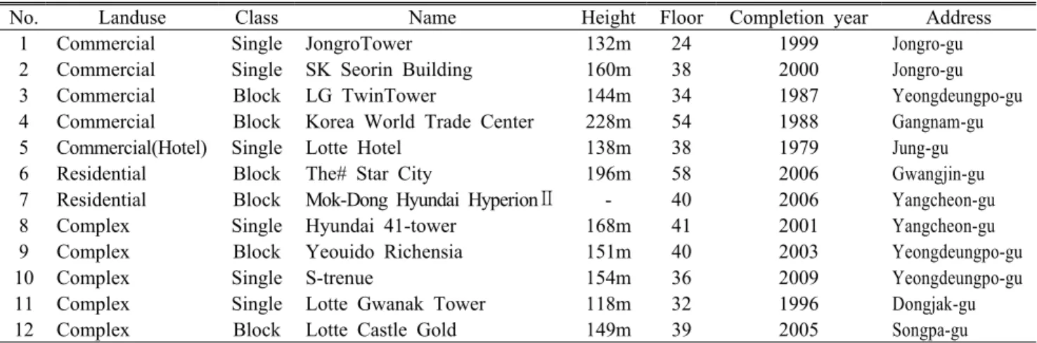
No. Landuse Class Name Height Floor Completion year Address
1 Commercial Single JongroTower 132m 24 1999 Jongro-gu
2 Commercial Single SK Seorin Building 160m 38 2000 Jongro-gu
3 Commercial Block LG TwinTower 144m 34 1987 Yeongdeungpo-gu
4 Commercial Block Korea World Trade Center 228m 54 1988 Gangnam-gu
5 Commercial(Hotel) Single Lotte Hotel 138m 38 1979 Jung-gu
6 Residential Block The# Star City 196m 58 2006 Gwangjin-gu
7 Residential Block Mok-Dong Hyundai HyperionⅡ - 40 2006 Yangcheon-gu
8 Complex Single Hyundai 41-tower 168m 41 2001 Yangcheon-gu
9 Complex Block Yeouido Richensia 151m 40 2003 Yeongdeungpo-gu
10 Complex Single S-trenue 154m 36 2009 Yeongdeungpo-gu
11 Complex Single Lotte Gwanak Tower 118m 32 1996 Dongjak-gu
12 Complex Block Lotte Castle Gold 149m 39 2005 Songpa-gu
Table 1. The general situation of the study site
Seoul
12 11
9 10 8 7
5 6
4 3
2 1
01 2.5 5 10 (km)
Figure 1. Location map of the study site 하여 저온역과 고온역의 온도차이를 검증하고자 하였다.
재료 및 방법
1. 연구대상지
연구대상지 선정은 2단계로 구분하였는데, 국내 초고층 건축물 중 2010년까지 완공예정인 초고층 건축물을 높이 순으로 정렬하여 50위까지를 1단계로 선정하였다. 2단계는 선정된 건축물 중 우리나라에서 가장 큰 도시인 서울 지역 을 대상으로 서울 시내 24층 이상의 초고층 건축물의 조성 시기, 규모, 용도, 지역 등을 고려하여 12개소를 선정하였 다. 지역별로 살펴보면 서울특별시 종로 일대에 상업지 2개 소, 상업지(호텔) 1개소, 송파/강남 일대에 상업지 1개소, 주거지 1개소, 주상복합지 2개소, 여의도/목동 일대에 상업 지 1개소, 주거지 1개소, 주상복합지 3개소이었다. 사용 용 도에 따라 상업지, 상업지(호텔), 주거지, 주상복합지로 나 누었으며, 건축물의 연계정도에 따라 단일건물과 건물군으 로 구분하였다. 건축물의 높이는 118~228m, 층고는 24~54 층에 이르기까지 다양하였다(Table 1, Figure 1).
종로타워는 남측으로는 종각과 청계천이 있었고, 고층상 업업무지가 밀집하여 인접하고 있었다. SK서린빌딩은 청 계천의 북측에 있으며, 세종로 사거리와 종각사거리 사이에 위치하였다. LG트윈타워는 동측에는 여의도공원이 있고, 북측에는 마포대교 교차로가 위치하며, 북동쪽에 한강이 흐 르고 있었다. 한국종합무역센터는 대단위 블록으로 조성되 어 있었으며, 3면이 10차선 이상의 도로로 둘러싸여 있었 다. 롯데호텔은 을지로입구 사거리 남서측에 위치하고 있으 며, 고밀도 초고층 건물들이 인접하고 있었다. 더샵스타시 티는 건국대학교의 남측에 위치하고 있으며, 남동측에는 대 면적 교육시설, 동남측에는 저층 다세대주택이 밀집하고 있
었다 . 목동 현대하이페리온Ⅱ은 안양천의 서측에 위치하고
있으며 사면이 4차선 이상의 도로로 둘러싸여있다. 현대41
타워는 초고층 빌딩이 밀집하여 있으며, 동측에는 대규모
주차장, 목동종합운동장 및 안양천이 위치하고 있었다. 여의
도 리첸시아는 남측에 샛강 및 올림픽대로가 위치하며 , 북측
에는 대규모 아파트단지인 시범아파트 , 은하아파트 등이 위
치하고 있다 . 에스트레뉴는 북서측에 여의도 공원이 위치하
고, 동측엔 한강이 위치하며, 고층 오피스빌딩이 밀집하여
인접하고 있었다 . 롯데관악타워는 보라매공원의 동측에 위
치하고 있었으며 , 초고층 건물들이 인접하고 있고, 남측에는
저층 주거지가 밀집하여 있다. 롯데캐슬골드는 잠실역 사거
리 북동측에 위치하고, 서측에는 녹지율이 높은 공동주거지
가 위치하며 , 남측에 롯데월드 및 석촌호수가 있었다.
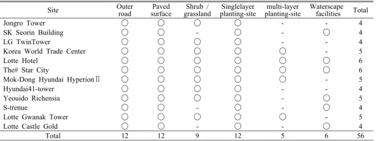
Site Outer
road Paved
surface Shrub /
grassland Singlelayer
planting-site multi-layer
planting-site Waterscape facilities Total
Jongro Tower ◯ ◯ ◯ ◯ - - 4
SK Seorin Building ◯ ◯ - ◯ - ◯ 4
LG TwinTower ◯ ◯ ◯ ◯ - - 4
Korea World Trade Center ◯ ◯ ◯ ◯ ◯ - 5
Lotte Hotel ◯ ◯ ◯ ◯ ◯ ◯ 6
The# Star City ◯ ◯ ◯ ◯ ◯ ◯ 6
Mok-Dong Hyundai HyperionⅡ ◯ ◯ ◯ ◯ ◯ - 5
Hyundai41-tower ◯ ◯ ◯ ◯ - - 4
Yeouido Richensia ◯ ◯ ◯ ◯ - ◯ 5
S-trenue ◯ ◯ - ◯ - ◯ 4
Lotte Gwanak Tower ◯ ◯ ◯ ◯ ◯ - 5
Lotte Castle Gold ◯ ◯ - ◯ - ◯ 4
Total 12 12 9 12 5 6 56
Table 2. Land cover type and number of study area (Unit : ea)
2. 조사분석방법1) 토지 피복 유형화
초고층 건축물 외부 공간 전체에 대한 토지 피복 현황은 1/1,000 지형도를 바탕으로 현장에서 각각의 유형을 구분하 여 조사하고 이를 전산 입력하였다. 대상지 내 토지 피복별 유형은 1차적으로 포장지, 식재지, 수경시설로 구분하였다.
포장지는 대상지 내의 포장지와 대상지에 인접한 외곽도로 로 구분하였고, 식재지는 층위구조 유형을 기준으로 관목/초 지, 단층교목식재지, 다층식재지로 구분하였다. 그리하여 외 곽도로, 포장지, 관목/초지, 단층교목식재지, 다층식재지, 수 경시설로 최종 6가지 토지 피복 유형을 설정하였다.
외곽도로 유형은 12개 건물의 주변 환경차이를 고려하기 위해 통제변인이 유사하다고 판단된 대상지 외 주변의 외곽 도로 중앙부에 대조구를 선정하였다. 대상지 내 포장지유형 은 통제변인의 제한이 어렵기 때문에 외곽도로의 피복과 동 일하나 구분하여 설정하였다. 관목/초지는 식재지 중 교목성 상의 수목이 없이 관목과 초지 층위로만 이루어진 지역으로 설정하였다. 단층교목식재지는 교목성상의 수목이 식재되어 있으나 하층수목이 부재한 곳으로 설정하였다. 다층식재지 는 식재지 중 교목성상과 관목/초지가 모두 식재된 곳으로 설정하였으며, 수경시설은 수 공간이 확보된 곳이거나 관련 시설이 위치한 곳으로 설정하였다.
2) 온도 측정
(1) 온도 측정일 선정건축물 외부 공간 녹지의 온도 저감 효과 측정 적정 시기 를 확인하기 위하여 서울시의 2005~2009년 월간 평균 온도 분석을 실시한 결과, 8월이 온도가 가장 높았고 그 중 8월
4~19일 사이의 온도가 다른 날짜에 비해 높은 분포를 보였 다 . 이에 본 연구는 연중 온도가 가장 높은 시기로 판단되는 시기를 고려하여 2010년 8월 17일, 하루 중 가장 더운 시간 인 14~16시 사이에 측정하였다.
(2) 온도 측정 방법
각 대상지 조사구별 온도 측정은 2인 1개조로 토지 피복유 형별로 측정을 실시하였다. 온도 측정은 오차범위가 ±0.5℃
인 TES-1341 계측기를 사용하여 측정 장소의 지상 1.5m에 서 7회 반복 측정하였으며, 관측된 온도를 근거로 지점별 평균 온도를 도출하여 온도 측정표를 작성하였다.
3) 통계분석
본 연구에서는 분산분석 중 일원배치 분산분석방법을 택 하여 두 단계에 걸쳐 실행하였다. 첫 번째는 주변여건이 상 이한 대상지들의 온도분포차이를 고려하기 위하여 실행하 였다. 유사한 온도분포를 보이는 대상지를 분류하기 위하여 대조구로 선정한 건축물을 둘러싸는 외곽도로에서 7회 반 복 측정한 온도의 평균값을 기준으로 대상지들을 각각 그룹 화 하였다 . 두 번째는 선행된 분산분석에서 분류된 그룹들 의 토지 피복 유형별 온도를 기준으로 분산분석을 실행하였 다. 그리하여 각 그룹별 토지 피복 유형들을 저온역 그룹과 고온역 그룹으로 분류해 토지 피복 유형별 온도 차이를 검 증하였다.
토지 피복유형에 따라서 온도 차이를 알아보기 위하여
영가설은 ‘토지 피복유형에 따라 온도차이가 있다.’로 설정
하였다. 다중비교 방법에는 Tukey HSD와 Dunkan의 방법
을 사용하였다.
Site
Lane Area ratio
Total area(㎡) Outer
road Building Paved
surface Shrub /
grassland Single-layer
planting-site Multi-layer
planting-siteWaterscape facilities
Jongro Tower 8 32.4 49.9 4.6 13.1 - - 6,503
SK Seorin Building 8 61.8 14.2 2.3 21.3 - 0.4 5,484
LG TwinTower 8 37.6 48.4 1.6 12.4 - - 13,982
Korea World Trade Center 14 54.8 35.3 2.9 1.2 5.2 0.6 184,603
Lotte Hotel 8 64.6 27.3 1.1 5.1 1.3 0.6 18,085
The# Star City 4 21.5 34.2 12.0 7.7 23.6 1.0 40,127
Mok-Dong Hyundai HyperionⅡ 8 26.3 42.0 6.9 7.0 17.8 - 28,818
Hyundai41-tower 8 53.5 39.6 1.4 5.5 - - 8,047
Yeouido Richensia 4 34.3 38.7 2.1 22.9 - 2.0 6,818
S-trenue 12 54.3 32.8 - 10.9 - 2.0 3,300
Lotte Gwanak Tower 12 40.5 45.4 5.2 0.2 8.7 - 4,530
Lotte Castle Gold 12 39.7 42.1 2.2 15.3 - 0.7 21,968
Average - 42.3 37.5 3.8 10.22 4.72 0.61 29,118
Table 3. Area ratio(lane for outer road) of land cover type of study area (Unit: %)
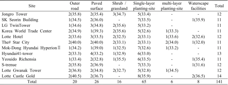
Site Outer
road
Paved surface
Shrub / grassland
Single-layer planting-site
multi-layer planting-site
Waterscape facilities Total
Jongro Tower 2(35.8) 2(35.4) 3(34.7) 5(33.4) - - 12
SK Seorin Building 1(34.5) 2(36.0) - 7(33.5) - 1(35.9) 11
LG TwinTower 1(34.6) 3(34.8) 2(35.6) 5(33.2) - 11
Korea World Trade Center 2(34.9) 1(39.3) 2(35.6) 5(32.6) 1(33.3) - 11
Lotte Hotel 2(33.6) 3(33.5) 2(32.5) 2(33.1) 1(33.6) 2(32.6) 12
The# Star City 2(40.0) 2(40.0) 2(33.1) 2(33.1) 2(34.0) 1(32.0) 11
Mok-Dong Hyundai HyperionⅡ 1(34.2) 1(39.0) 1(32.5) 7(32.6) 1(33.2) - 11
Hyundai41-tower 2(33.3) 4(33.2) 1(32.9) 6(33.0) - - 13
Yeouido Richensia 1(33.4) 2(32.8) 1(35.5) 6(33.5) - 1(35.4) 11
S-trenue 2(35.8) 2(36.9) - 7(33.3) - 1(31.6) 12
Lotte Gwanak Tower 2(36.8) 2(34.8) 2(32.7) 5(32.8) 1(34.5) 12
Lotte Castle Gold 2(40.5) 2(36.7) - 8(35.9) - 2(36.5) 14
Total 20 26 16 65 6 8 141
Table 4. The number of temperature measurement spot by land cover type(average temperature(℃)) (Unit : ea)
결과 및 고찰
1. 토지 피복 유형 분류
대상지 12개소의 토지 피복유형별로 분류한 결과, 대상 지별 토지 피복유형 개수는 종로타워 4개 유형, SK서린빌 딩 4개 유형, LG트윈타워 4개 유형, 한국종합무역센터 5개 유형, 롯데호텔 6개 유형, 더샵스타시티 6개 유형, 목동 현 대하이페리온Ⅱ 5개 유형, 현대41타워 4개 유형, 여의도 리 첸시아 5개 유형, 에스트레뉴 4개 유형, 롯데관악타워 5개 유형, 롯데캐슬골드 4개 유형이었다. 외곽도로와 포장지, 단 층교목식재지의 유형들은 모든 곳에서 나타나고 있으나 관
목/초지, 다층식재지, 수경시설들을 조성한 곳은 상대적으 로 적었다. 유형은 전체적으로 4~5개 유형인 지역이 많았고 6개 유형이었던 곳은 롯데호텔과 더샵스타시티 2개소가 있 었다(Table 2).
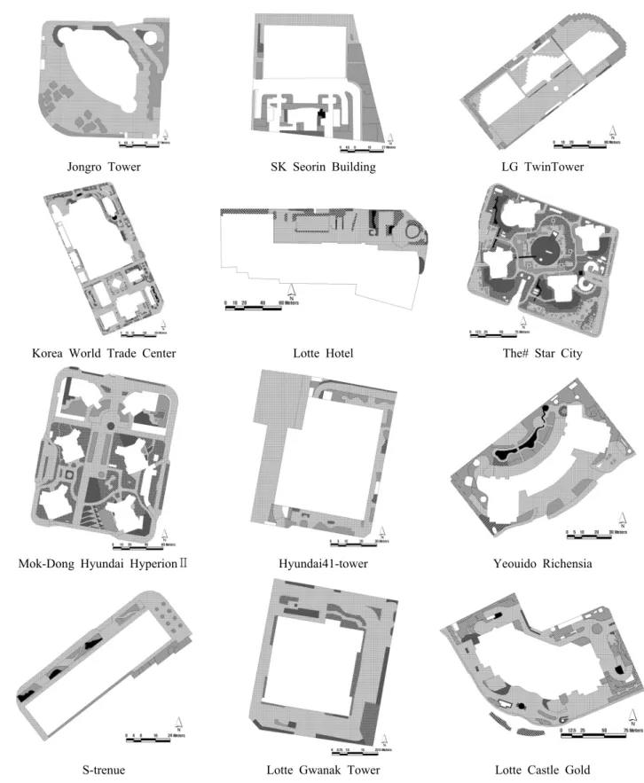
Table 3은 대상지 12개소의 토지 피복 유형별 면적비율 과 외곽도로 차선 수이다. 건폐지의 평균 면적비율은 42.3%, 포장지는 37.5%로 건폐지와 포장지 등 인공물이 차지하고 있는 면적이 79.8%로 넓었다. 식재지 19.2% 중 다층식재지의 면적비율은 10.8%, 단층교목식재지 3.8%, 관목/초지 3.8%이었으며, 수 공간을 포함한 녹지는 20.2%
이었다 (Figure 2).
Jongro Tower SK Seorin Building LG TwinTower
Korea World Trade Center Lotte Hotel The# Star City
Mok-Dong Hyundai HyperionⅡ Hyundai41-tower Yeouido Richensia
S-trenue Lotte Gwanak Tower Lotte Castle Gold
Figure 2. Land cover condition of the study site
( )
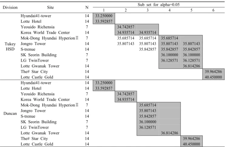
Division Site N Sub set for alpha=0.05
1 2 3 4 5 6
Tukey HSD
Hyundai41-tower 14 33.250000
Lotte Hotel 14 33.592857
Yeouido Richensia 7 34.742857
Korea World Trade Center 14 34.935714 34.935714
Mok-Dong Hyundai HyperionⅡ 7 35.685714 35.685714 35.685714
Jongro Tower 14 35.807143 35.807143 35.807143 35.807143
S-trenue 14 35.842857 35.842857 35.842857
SK Seorin Building 7 36.100000 36.100000
LG TwinTower 7 36.128571 36.128571
Lotte Gwanak Tower 14 36.814286
The# Star City 14 39.964286
Lotte Castle Gold 14 40.450000
Duncan
Hyundai41-tower 14 33.250000
Lotte Hotel 14 33.592857
Yeouido Richensia 7 34.742857
Korea World Trade Center 14 34.935714
Mok-Dong Hyundai HyperionⅡ 7 35.685714
Jongro Tower 14 35.807143
S-trenue 14 35.842857
SK Seorin Building 7 36.100000
LG TwinTower 7 36.128571
Lotte Gwanak Tower 14 36.814286
The# Star City 14 39.964286
Lotte Castle Gold 14 40.450000
Table 6. Homogeneous subsets according to the temperature of study site's outer road (Unit : ℃)
LeveneStatistic df Mean
Square F Sig.
6.460 11 65.152 117.187 .000
Table 5. Test of homogeneity of variances of outer road
2. 토지 피복 유형별 온도 측정 및 분석
1) 토지 피복 유형별 온도 측정
토지 피복 유형에 따라 대상지별로 온도 측정지점을 11~14개소 선정하여 각 측정지점에서 7회씩 반복하여 온도 를 측정하였다. 온도 측정결과에 따라 반복한 7회의 평균값 을 그 지점의 대표값으로 선정하였다. 총대상지의 유형 중 단층교목식재지에서의 측정 개소수가 65개로 가장 많았으 며, 포장지, 외곽도로, 관목/초지, 수경시설, 다층식재지 순 으로 26개소, 20개소, 16개소, 8개소, 6개소이었다(Table 4).
2) 기준 측정값에 의한 대상지 그룹화
기준 측정된 외곽 도로를 중심으로 일원배치 분산분석을 실시하여 대상지별 온도분포가 유사한 지역을 4개 그룹으 로 분류하였다(Table 5). 온도가 가장 낮은 Group-1은 현대 41타워, 롯데호텔, Group-2는 여의도 리첸시아, 한국종합무 역센터, Group-3은 목동 현대하이페리온Ⅱ, 종로타워, 에스 트레뉴, SK서린빌딩, LG트윈타워, 롯데관악타워, 온도가 가장 높은 Group-4는 더샵스타시티, 롯데캐슬골드이었다
(Table 6, Table 7).
3) 대상지 그룹별 온도 분석
(1) Group-1기존 측정값에 의해 1차 분류된 그룹별로 토지 피복유형
별 온도와의 관계를 알아보기 위하여 일원배치 분산분석을
실시하였다(Table 8). 온도가 가장 낮고 고르게 측정된
Group-1에 속한 현대41타워, 롯데호텔의 경우 Table 9에서
저온역그룹에 수경시설, 관목/초지, 단층교목식재지가 속하
였고 고온역그룹에 포장지 , 외곽도로, 다층식재지가 분류되
었지만 그룹 간 온도 차이는 거의 없었다 . 가장 낮은 온도를
보인 수경시설과 가장 높은 온도를 보인 다층식재지의 온도
Group Site(average temperature(℃)) 1 Hyundai 41-Tower(33.3),
Lotte Hotel(33.6) 2 Yeouido Richensia(34.7),
Korea World Trade Center(34.9)
3
Mok-Dong Hyundai HyperionⅡ(35.6), JongroTower(35.8),
S-trenue(35.8),
SK Seorin Building(36.1), LG TwinTower(36.1), Lotte Gwanak Tower(36.8) 4 The# Star City(40.0),
Lotte Castle Gold(40.5)
Table 7. The study area classification for each temperature distribution of the outer road
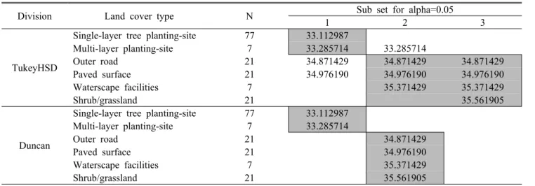
Division Land cover type N Sub set for alpha=0.05
1 2 3
TukeyHSD
Waterscape facilities 14 32.564286
Shrub/grassland 22 32.613636
Single-layer tree planting-site 56 33.003571 33.003571
Paved surface 49 33.338776
Outer road 28 33.421429
Multi-layer planting-site 7 33.628571
Duncan
Waterscape facilities 14 32.564286
Shrub/grassland 22 32.613636
Single-layer tree planting-site 56 33.003571 33.003571
Paved surface 49 33.338776 33.338776
Outer road 28 33.421429 33.421429
Multi-layer planting-site 7 33.628571
Table 9. Homogeneous subsets of Group-1 according to land cover type (Unit: ℃)
LeveneStatistic df Mean
Square F Sig.
13.859 5 3.476 6.574 .000
Table 8. Test of homogeneity of variances of Group-1
차는 1.06℃이었다. 이 중 롯데호텔은 건축물이 남측에 위 치하여 측정지점 대부분이 그늘지역이었다. 이는 건축물로 인해 감소된 지면도달 일사량으로 고층건물의 영향을 많이 받는 지점들의 온도가 낮게 측정되도록 기인한 것으로 추정 되었다(Pack and Kim, 2010). 반면 현대41타워의 경우는 대상지내 조성된 식재지의 면적이 협소하여 측정된 온도의 차이가 적고 고르게 측정된 것으로 추정되었다. 특히 다층 식재지는 조성된 유형의 사례수가 적고 면적이 협소하여 온도 측정시 다른 측정지점보다 온도가 높게 나오는 현상이 있었다.
(2) Group-2
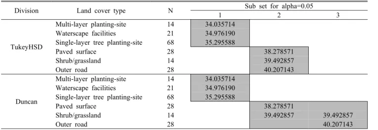
토지 피복유형별 다중비교를 통하여 Group-2에 속한 여 의도 리첸시아, 한국종합무역센터의 온도분포 분류를 실시 하였다 (Table 10, Table 11). 저온역그룹에 단층교목식재 지, 다층식재지, 외곽도로가 속하였고, 고온역그룹에는 포 장지, 수경시설, 관목/초지가 속하였다. 가장 온도가 낮은 단층교목식재지와 가장 온도가 높은 관목/초지의 온도 차이 는 약 2.45℃의 차이를 보였다. 수경시설은 수공간의 면적 이 협소하여 그 영향이 거의 없었던 것으로 추정되었다. 관 목/초지는 온도가 높게 나타났는데 이는 식재지의 수고별 식재량은 모두 온도저감에 효과적이고 그 효율성은 교목, 소교목 , 관목의 순이나, 교목과 소교목의 차이는 아주 작은 반면, 지면에 도달하는 일사량을 차단하지 못하는 관목층은 그 역할이 거의 없더라는 기존 연구결과(Yoon, 2004)와 일 치하였다.
(3) Group-3
가장 많은 대상지가 포함된 Group-3에는 목동 현대하이
페리온Ⅱ, 종로타워, 에스트레뉴, SK서린빌딩, LG트윈타
워, 롯데관악타워가 속해있으며 이들 대상지의 온도분포분
류를 토지 피복유형별 다중비교을 실시하였다(Table 12,
Table 13). 저온역그룹에 단층교목식재지, 수경시설, 다층
식재지가 속하였으며, 고온역그룹에는 관목/초지, 포장지,
외곽도로가 속하였다. 가장 온도가 낮은 단층교목식재지와
가장 온도가 높은 외곽도로의 온도 차이는 약 2.97℃의 차
이를 보였고 , 저온역그룹에 상대적으로 온도가 낮은 식재지
와 수경시설이 속하여 포장면이 아닐 때 온도가 더 낮다는
것이 관찰되었다 . 이는 식재지와 수경시설이 포장면에 비해
저온역에 속한다는 선행 연구 (Hong and Lee, 2004; Hong
et al., 2005)와 유사한 결과로 확인되었다. 고온역그룹에는
Levene
Statistic df Mean
Square F Sig.
15.547 5 179.481 81.419 .000
Table 12. Test of homogeneity of variances of Group-3
LeveneStatistic df Mean
Square F Sig.
18.423 5 32.821 8.085 .000
Table 10. Test of homogeneity of variances of Group-2
Division Land cover type N Sub set for alpha=0.05
1 2 3
TukeyHSD
Single-layer tree planting-site 252 33.123016
Waterscape facilities 14 33.714286 33.714286
Multi-layer planting-site 14 33.850000 33.850000
Shrub/grassland 56 34.130357
Paved surface 85 35.829412
Outer road 63 36.093651
Duncan
Single-layer tree planting-site 252 33.123016
Waterscape facilities 14 33.714286 33.714286
Multi-layer planting-site 14 33.850000
Shrub/grassland 56 34.130357
Paved surface 85 35.829412
Outer road 63 36.093651
Table 13. Homogeneous subsets of Group-3 according to land cover type (Unit: ℃)
Division Land cover type N Sub set for alpha=0.05
1 2 3
TukeyHSD
Single-layer tree planting-site 77 33.112987
Multi-layer planting-site 7 33.285714 33.285714
Outer road 21 34.871429 34.871429 34.871429
Paved surface 21 34.976190 34.976190 34.976190
Waterscape facilities 7 35.371429 35.371429
Shrub/grassland 21 35.561905
Duncan
Single-layer tree planting-site 77 33.112987
Multi-layer planting-site 7 33.285714
Outer road 21 34.871429
Paved surface 21 34.976190
Waterscape facilities 7 35.371429
Shrub/grassland 21 35.561905
Table 11. Homogeneous subsets of Group-2 according to land cover type (Unit: ℃) 관목/초지, 외곽도로, 포장면이 속하였다.
건축물의 외부 공간 조성시 온도가 낮았던 수경시설과 단층교목식재지, 다층식재지는 수면을 핵으로 그 주변에 증 발산량이 많은 교목 또는 교목+아교목의 층위구조를 갖도 록 식재하며, 가능한 한 물의 순환을 촉진시킬 수 있는 분수 대, 벽천 등의 설치가 온도저감에 효율적(Yoon et al., 2008) 인 것으로 보고되었다. 그러나 무분별한 식재지와 수경시설 의 조성은 기류속도의 저감과 습도 증가로 인해 거주자의 온열쾌적감은 떨어지는 결과(Lim et al., 2008)를 초래하므
로 풍향, 풍속, 국지성환류, 바람길 등에 대한 사전의 면밀한 검토 후 조성을 할 필요성이 있다고 판단된다.
(4) Group-4
토지 피복유형별 다중비교를 통하여 Group-4에 속한 더
샵스타시티, 롯데캐슬골드의 온도분포분류를 실시하였다
(Table 14, Table 15). Group-4는 저온역그룹에 다층식재지,
수경시설, 단층교목식재지가 속하였으며, 고온역그룹에는
포장지 , 관목/초지, 외곽도로가 속하였다. 가장 온도가 낮은
Group A-Group B-Group 1 Waterscape facilities(32.6), Shrub/grassland(32.6),
Single-layer tree planting-site(33.0) Paved surface(33.3), Outer road(33.4), Multi-layer planting-site(33.6)
2 Single-layer tree planting-site(33.1),
Multi-layer planting-site(33.3) Outer road(34.9), Paved surface(35.0),
Waterscape facilities(35.4), Shrub/grassland(35.6) 3 Single-layer tree planting-site(33.1),
Waterscape facilities(33.7), Multi-layer planting-site(33.9) Shrub/grassland(34.1), Paved surface(35.8), Outer road(36.1)
4 Multi-layer planting-site(34.0), Waterscape facilities(35.0),
Single-layer tree planting-site(35.3) Paved surface(38.3), Shrub/grassland(39.5), Outer road(40.2)
Table 16. Analysis synthesis(average temperature(℃))
Division Land cover type N Sub set for alpha=0.05
1 2 3
TukeyHSD
Multi-layer planting-site 14 34.035714
Waterscape facilities 21 34.976190
Single-layer tree planting-site 68 35.295588
Paved surface 28 38.278571
Shrub/grassland 14 39.492857
Outer road 28 40.207143
Duncan
Multi-layer planting-site 14 34.035714
Waterscape facilities 21 34.976190
Single-layer tree planting-site 68 35.295588
Paved surface 28 38.278571
Shrub/grassland 14 39.492857 39.492857
Outer road 28 40.207143
Table 15. Homogeneous subsets of Group-4 according to land cover type (Unit: ℃)
LeveneStatistic df Mean
Square F Sig.
30.645 5 163.675 30.786 .000
Table 14. Test of homogeneity of variances of Group-4
다층식재지와 가장 온도가 높은 외곽도로의 온도 차이는 총 4가지 Group 중 가장 큰 폭인 약 6.17℃의 차이를 보였다.
온도분포상 유형의 분류는 Group-3과 유사하게 분류되었 다. 다층식재지, 수경시설과 단층교목식재지가 저온역인 저 온역그룹에 속하였고, 고온역그룹에는 포장지, 관목/초지와 외곽도로가 속하였다. 이 중 관목/초지유형은 그 면적이 협 소하고, 일사에 대한 지표도달양을 감소시키지 못하여 측정 된 온도가 높게 나타난 것으로 추정된다. Group-4에서 토지 피복유형을 포장지와 다층식재지, 단층교목식재지의 온도 차이는 2.98~4.24℃로 나타났다.
(5) 종합
Table 16은 4개 그룹의 저온역과 고온역에 속한 유형들 을 종합한 결과로서, 단층교목식재지와 다층식재지, 수경시
설은 대체적으로 저온역으로 분류되었고, 포장지와 외곽도 로, 관목/초지는 고온역으로 분류되었다. Group-1, Group-2, Group-3, Group-4의 분산분석 결과를 통하여 토지 피복유 형이 인공물로 조성된 포장지와 외곽도로는 식재지로 조성 된 곳에 비하여 온도가 약 1.06~6.17℃ 더 높은 것으로 나타 났다. 건물의 영향으로 그늘진 지역을 측정한 온도는 자료 비교에 다소 문제가 있었고, 소규모로 조성된 식재지나 수 경시설의 효과는 미미한 것으로 판단되었다 . 이에 각 공간 에 필요한 녹지량과 수공간의 면적을 조성 전 미리 산출하 여, 효과를 발휘할 수 있는 최소한의 면적과 녹지량을 확보 할 필요성이 있다고 판단되었다 .
최근 고밀한 도심지역에서 초고층 건축물들이 건설되는
경향이 증가하고 있다 . 이러한 도시개발은 도시환경을 악화
시키는 원인이 되고 있으며, 특히 도시온도를 높여 도시열
섬현상을 발생시키고 있다. 도시의 온도가 높아지는 영향을
저감시키기 위해서는 기본적으로 건물외부공간의 양적녹
지증진이 필요하며, 조성 방법에 따라 온도저감에 의한 냉
방부하 저감 등 에너지 소비 감소효과를 높일 수 있다. 본
연구를 통해 조성된 녹지 중 단층교목식재지와 다층식재지
로 조성된 지역이 상대적으로 저온역에 대다수 포함된 것을 밝혀내었다. 초고층 건축물의 외부공간의 조성 시 단층교목 식재지, 다층식재지와 수경시설로 조성 한다면 본 연구결과 인 1.06~6.17℃의 저감효과와 유사한 효과를 볼 수 있을 것으로 판단되었다. 또한, 건물 외부의 변수와 기후에 대한 영향이 많은 실측조사에 대해 지속적인 온도 측정과 관련연 구에 대한 지속성이 필요하다고 판단되었다.
인용문헌
Ahn, J.S., H.D. Kim and S.W. Kim(2010) Effect of Difference of Land Cover Conditions on Urban Thermal Environment in Daegu Using Satellite and AWS Data. Journal of the Environmental Sciences 19(3): 281-293. (in Korean with English abstract)
Cleugh, H.A. and C.S.B. Grimmond(2001) Modelling regional scales surface energy exchanges and CBL growth in a heteroge- neous, urban-rural landscape. Bound Lay Meteorol 98: 1–31.
Figuerola, P.I. and N. Mazzeo(1998) Urban–rural temperature dif- ferences in Buenos Aires. Int J Climatol 18: 1,709–1,723.
Gallo K.P., A.L. McNab, T.R. Karl, J.F. Brown, J.J. Hood and J. D.
Tarpley(1993) The use of NOAA AVHRR data for assessment of the urban heat island effect. J Appl Meteorol 32: 899–908.
Gallo, K.P. and T.W. Owen(1998) Assessment of urban heat island:
A multi-sensor perspective for the Dallas-Ft. Worth, USA region. Geocarto International 13: 35–41.
Gao, X.J., Y. Luo, W.T. Lin, Z.C. Zhao and F. Giorgi(2003) Simulation of effects of land use change on climate in China by a regional climate model. Adv Atomos Sci 20: 583–592.
Gillies, R.R. and T.N. Carlson(1995) Thermal remote sensing of surface soil water content with partial vegetation cover for in- corporation into climate models. Journal of Applied Meteorology 34: 745–756.
Gillies, R.R., T.N. Carlson, J.Cui, W.P. Kustas and K.S.
Humes(1997) A verification of the ‘riangle’method for obtain- ing surface soil water content and energy fluxes from remote measurements of the Normalized Difference Vegetation in- dex(NDVI) and surface radiant temperature. International Journal of Remote Sensing 18: 3,145–3,166.
Goward, S.N., Y. Xue and K.P. Czajkowski(2002) Evaluating land surface moisture conditions from the remotely sensed temper- ature/vegetation index measurements: An exploration with the simplified simple biosphere model. Remote Sensing of Environment 79: 225–242.
Hong, S.H. and K.J. Lee(2004) Variation Profiles of Temperature by Green Area of Apartments in Gangnam, Seoul. Korean Journal of environment and Ecology 18(1): 53-60. (in Korean with English abstract)
Hong, S.H., K.J. Lee and B.H. Han(2005) Analysis of Temperature Profiles by Land Use and Green Structure on Built-up Area.
Korean Journal of environment and Ecology 19(4): 375-384.
(in Korean with English abstract)
Jo, H.K. and T.W. Ahn(1999) Function of Microclimate Amelioration by Urban Greenspace. The Korean Institute of Landscape Architecture 27(4): 23-28. (in Korean with English abstract)
Kim, J.C., K.S. Kim and S.J. Lee(2006) A Study on the Area Distribution Ratio in the Public Space of Super High-rise Apartment. Journal of Architectural Institute of Korea Vol.2 No.1: 15-20. (in Korean with English abstract)
Klysik, K. and K. Fortuniak(1999) Temporal and spatial character- istics of the urban heat island of Lodz, Poland. Atmospheric Environment, 33: 3,885−3,895.
Lambin E.F., X. Baulies, N. Bockstael, G. Fischer, T. Krug, R.
Leemans, E.F. Moran, R.R. Rindfuss, Y. Sato, D. Skole , B.L.
II. Turber and C. Vogel(1999) IGBP Report No.48=IHDP Report No. 10: Land-use and land-cover change im- plementation strategy. IGBP Secretariat, The Royal Swedish Academy of Sciences, pp. 75–85.
Lee, S.H.(2007) A study on Usage of the Public Open Space in High Rise Mixed-use Building. Thesis for the Degree of Master, Graduate School, Seoul National University of Technology, 95pp. (in Korean with English summary)
Lim, J.Y., H.K. Hwang, D.S. Song and T.Y. Kim(2008) Assessment on Thermal Environment and Human Thermal Comfort in Residential Building Block through Field Measurement.
Presented at the 2008 annual meeting of the Korean Solar Energy Society, pp. 311-317.
Lu, D. and Q. Weng(2006) Spectral mixture analysis of ASTER im- ages for examining the relationship between urban thermal fea- tures and biophysical descriptors in Indianapolis, Indiana, USA. Remote Sens Environ 104: 157–167.
Nichol, J.E.(1998) Visualization of urban surface temperatures de- rived from satellite images. Int J Remote Sens 19: 1,635–1,637.
Park, M.H. and H.D. Kim(2010) Cool Island Intensity in a Large Urban Green in Downtown Daegu: Seasonal Variation and Relationship to Atmospheric Condition. Journal of the Environmental Sciences 19(1): 81-87. (in Korean with English abstract)
Quattrochi, D.A. and M.K. Ridd(1998) Analysis of vegetation within a semiarid urban environment using high spatial reso- lution airborne thermal infrared remote sensing data. Atmos Environ 32: 19–33.
Quattrochi, D.A. and J.C. Luvall(1999) Thermal infrared remote sensing for analysis of landscape ecological processes: meth- ods and applications. Landscape Ecology 14(6): 577-598.
Seong, T.J. and G.J. Si(2009) Research Methodology. Hakjisa,
478pp. (in Korean)
Streutker, D.R.(2002) A remote sensing study of the urban heat is- land of Houston, Texas. Int J Remote Sens 23: 2,595–2,608.
Streutker, D. R.(2003) Satellite-measured growth of the urban heat island of Houston, Texas. Remote Sensing of Environment 85:
282−289.
Voogt, J.A. and T.R. Oke(2003) Thermal remote sensing of urban climates. Remote Sensing of Environment 86: 370−384.
Wei, H.L. and C.B. Fu(1998) Study of the sensitivity of a regional model in response to land cover change over northern China.
Hydrol Process 12: 2,249–2,265.
Weng, Q.(2001) A remote sensing-GIS evaluation of urban ex- pansion and its impact on surface temperature in the Zhujiang Delta, China. International Journal of Remote Sensing 22:
1,999–2,014.
Weng, Q., D. Lu and J. Schubring(2004) Estimation of land surface temperature—egetation abundance relationship for urban heat island studies. Remote Sens Environ 89: 467–483.
White, M.A., R.R. Nemani, P.E. Thornton and S.W. Running(2002)
Satellite evidence of phenological differences between urban- ized and rural areas of the eastern United States deciduous broadleaf forest. Ecosystems 5: 260–277.
Wilson, J.S., M. Clay, E. Martin, D. Stuckey and V.R. Kim(2003) Evaluating environmental influences of zoning in urban eco- systems with remote sensing. Remote Sens Environ 86: 303–
321.
Xian, G. and M. Crane(2006) An analysis of urban thermal charac- teristics and associated land cover in Tampa Bay and Las Vegas using Landsat satellite data. Remote Sens Environ 104: 147–
156.
Yoon, Y.H.(2004) Positive Study of How Green Zones in the City Effect the Relief of Micro-Climate Control. Korean Journal of environment and Ecology 22(2): 279-286. (in Korean with English abstract)
Yoon, Y.H., B.J. Park, W.T. Kim and H.S. Cho(2008) The Intensity of the Urban Heat Island by Seasons According to Land Use Patterns. Journal of the Korea Planners Association 43(4):
21-30. (in Korean with English abstract)