UAV를 이용한 농경지 분광특성 및 식생지수 분석*
이근상
1·최연웅
2※Analysis of Cropland Spectral Properties and Vegetation Index Using UAV*
Geun-Sang LEE
1·Yun-Woong CHOI
2※1
요 약
원격탐사 기술은 플랫폼 개발, 탐사면적 및 탐사기능 등 양적 및 질적 향상의 관점에서 지속적 으로 발전되어왔으며 비용절감 및 현장자료보완의 방법으로 유용하게 활용되고 있다. 최근에는 농 업분야에서의 활용사례와 관련연구가 증가하는 추세에 있으며 농경지의 상태를 탐지하고 정량화하 여 농경지 및 농업환경에 대한 관리방안 수립 및 정책지원이 가능하기 때문에 농작물 생육이상 판 별, 시계열 정보에 의한 작황 추정 등 다양한 분야에서 연구되고 있다. 본 연구에서는 다중분광센 서를 장착한 UAV를 이용하여 간척지 농경지에 대한 식생지수를 분석하고자 하였다. 한편, UAV 를 이용하여 취득한 다중분광영상 자료로부터 산정된 식생지수의 정확도를 평가하기 위해서 현지 조사를 실시하였다. 현지조사에 의한 식생지수와 UAV 다중분광영상으로부터 산정된 식생지수간의 상관성을 평가함으로써 가장 적절한 식생지수를 도출하였으며 대상지역 전체에 대한 식생지수 분 석에 활용하고자 하였다.
주요어 : 원격탐사, 분광특성, 식생지수, 무인항공기
ABSTRACT
Remote sensing technology has been continuously developed both quantitatively and qualitatively, including platform development, exploration area, and exploration functions.
Recently, the use cases and related researches in the agricultural field are increasing.
Also, since it is possible to detect and quantify the condition of cropland and establish management plans and policy support for cropland and agricultural environment, it is
2019년 11월 27일 접수 Received on November 27, 2019 / 2019년 12월 17일 수정 Revised on December 17, 2019 / 2019년 12월 18일 심사완료 Accepted on December 18, 2019
* 본 연구는 2019학년도 전주비전대학교 교내 연구비 지원에 의하여 이루어졌으며 이에 감사드립니다.
1 전주비전대학교 지적토목학과 Dept. of Cadastre & Civil Engineering, Vision College of Jeonju 2 조선이공대학교 토목건설과 Dept. of Civil Construction Engineering, Chosun College of Science &
Technology
※ Corresponding Author E-mail : [email protected]
being studied in various fields such as crop growth abnormality determination and crop estimation based on time series information. The purpose of this study was to analyze the vegetation index for agricultural land reclamation area using a UAV equipped with a multi-spectral sensor. In addition, field surveys were conducted to evaluate the accuracy of vegetation indices calculated from multispectral image data obtained using UAV. The most appropriate vegetation index was derived by evaluating the correlation between vegetation index calculated by field survey and vegetation index calculated from UAV multispectral image, and was used to analyze vegetation index of the entire area.
KEYWORDS : Remote sensing, Spectral property, Vegetation index, UAV
서 론
원격탐사 기술은 플랫폼 개발, 탐사면적 및 탐사기능 등 양적 및 질적 향상의 관점에서 지 속적으로 발전되어왔으며(Hunt
et al
., 2003;Toevs
et al
., 2011), 비용절감 및 현장자료보완의 방법으로 유용하게 활용되고 있다
(Laliberte
et al
., 2007; Boothet al
., 2008).최근에는 농업분야에서의 활용사례와 관련연구 가 점차 증가하는 추세에 있으며(Lee
et al
., 2011; Namet al
., 2015), 토양, 작물, 기후를 포함하는 농경지의 상태를 탐지하고 정량화하여 농경지 및 농업환경에 대한 장·단기적인 관리 방안과 정책지원 자료 제공이 가능하기 때문에 농작물 생육이상 판별, 시계열 정보에 의한 작 황 추정모형 구축 등 다양한 분야에서 연구되고 있다(Honget al
., 2012; Naet al
., 2013).특히, 근적외선(near infra red, NIR)영역의 파 장을 반사하는 식물 내 엽록소의 분광학적 특성 에 기반한 식생지수(vegetation index, VI)는 원격탐사 분야에서 식생분포와 생육특성을 평가 하는 대표적인 지표로 사용되어 왔다(Tomas and Gausman, 1977; Na
et al
., 2016).한편, 기술의 발전에 따라 고해상도의 자료를 안정적, 반복적으로 취득할 수 있다는 장점을 이유로 공간정보 제작, 방재, 국토개발, 농업 및 환경분야 등 다양한 분야에서 무인항공기 (unmanned aerial vehicle, UAV)의 활용 및 관련연구가 활발하게 진행되고 있다(Flynn and
Chapra, 2014; Zaman
et al
., 2014; Choiet al
., 2015; Pajares, 2015; Su and Chu, 2015; Leeet al
., 2016; Watanabe and Kawaharab, 2016; Jeonget al
., 2018).일반적으로 위성영상은 광범위한 지역의 공간 정보를 획득할 수 있는 장점에 비해 기상조건 등 광학적 간섭이 크고, MODIS(MODerate resolution Imaging Spectroradiometer), AVHRR (Advanced Very High Resolution Radiometer) 등 짧은 주기의 반복적인 영상취득이 가능한 저 해상도 위성영상을 제외하고는 시공간적 해상도 의 제약이 있어(Morel
et al
., 1977; Hassanet al
., 2011), 우리나라와 같이 소규모 면적에 여러 작물을 재배하는 혼작형태의 작부체계 환 경에서는 공간해상도가 낮아 정밀 농업 모니터 링에 적합하지 않은 문제점이 있다(Park and Park, 2015). 그러나, 최근 활용도가 높아지고 있는 무인항공기를 이용한 원격탐사는 신속성, 동시성을 가지며 소규모 지역에 대해 고해상도 영상자료를 얻을 수 있기 때문에 특정 장소에 대하여 더욱 정밀한 분석이 가능하며(Kimet al
., 2014; Naet al
., 2016), 대축척 수치지도 및 3차원 공간정보 제작을 위한 충분한 정확도 확보가 가능한 것으로 알려져 있다(Leeet al
., 2015).농업분야에서의 무인항공기 활용연구는 농업 환경 감시 및 모니터링, 토지피복분류, 작황분석 및 생육추정 등을 중심으로 진행되어 왔다 (Herwitz
et al
., 2004; Dieteret al
., 2005;Hassan
et al
., 2011; Junget al
., 2015;Feng
et al
., 2015). Candiagoet al
.(2015)은 UAV의 다중분광(multispectral)센서를 이용하 여 취득한 영상을 식생지수를 이용하여 정밀농 업에 활용할 수 있는 자료 생성방안을 연구하였 고, Leeet al
.(2015)은 UAV를 이용하여 취득 한 영상에서 식생지수를 추출하고 질소 생산량 과의 비교를 통하여 재배단지 내 질소 생산량의 공간적 분포 특성을 추정하였다. Leeet al
. (2016)은 UAV와 다중분광 카메라를 이용하여 시계열 다중분광 영상을 촬영하고 정규화식생지 수(normalized difference vegetation index, NDVI)를 추출하였으며, 생성된 NDVI를 이용한 작물의 생체량, 엽록소 함량 및 질소량 등 작물 생육 인자 추정이 가능하다고 제시하였다. Naet al
.(2016)은 고랭지배추를 대상으로 생육기 간 동안 드론 영상을 이용하여 생성한 시계열 NDVI와 기상요인 및 생육인자와의 상관성을 분 석하고, 이를 이용하여 원격탐사 기반의 고랭지 배추 생육추정 모형을 개발하였다. Imet al
. (2018)은 드론을 이용하여 무의 시들음병 피해 지역의 가시광선영역과 근적외선 영역의 영상을 취득하고, 무, 땅, 비닐 영역의 NDVI값을 비교 하였으며, 무의 시들음병 정도에 따라 정상, 초 기, 중기, 말기로 구분하여 NDVI 값 비교를 수 행하였다. Kim and Na(2019)는 드론을 이용 하여 농산물의 작황 및 재배면적을 모니터링 하 고자 하였다. 표본 필지에 대하여 현장조사 데 이터와 NDVI를 토대로 작황추정 모형을 구성하 여 농업작황 모니터링에 필요한 다양한 종류의 재배현황맵을 체계적으로 제작하였고 공간정보 기반의 정식면적 변화정보를 통해 해당 작물의 출하량 변화 예측에 효율적으로 활용 가능할 것 으로 판단하였다. 또한, 농촌진흥청 국립농업과 학원에서는 채소의 안정적인 공급을 위해 재배 면적 및 단수 예측이 필요하다고 판단하여 2015년부터 2018년까지 4년간 채소 작황과 관 련된 연구에 UAV를 적극적으로 활용하고 있다 (Naet al
., 2016).본 연구에서는 다중분광센서를 장착한 UAV를 이용하여 간척지 농경지에 대한 식생지수를 분석 하고자 하였다. 한편, UAV를 이용하여 취득한 다
중분광영상 자료로부터 산정된 식생지수의 정확도 를 평가하기 위해서는 분광계(spectrometer)를 이용하여 주요지점에 대한 현지조사를 실시하였 다. 이를 통해 본 연구에서는 현지조사에 의한 식생지수와 UAV 다중분광영상으로부터 산정된 식생지수간의 상관성을 평가함으로써 가장 적절 한 식생지수를 도출하였으며 대상지역 전체에 대한 식생지수 분석에 활용하고자 하였다.
연구 방법
1. 식생지수
1960년대 이후 원격탐사 자료로부터 식물의 생물학적 특성을 나타내는 다양한 인자들을 밝 혀내고자 노력해 왔으며, 이러한 노력의 대부분 은 식생지수의 개발로 이어져왔다. 식생지수는 단위가 없는 복사값으로 녹색식물의 상대적 분 포량과 활동성, 엽면적지수, 엽록소함량, 엽록소 함량 및 광합성 흡수복사량 등과 관련된 지표로 써, 학자들마다 여러 가지 반사파장에 따른 식 생군락의 밀도와의 상관을 밝히는데 이용되면서 구성식의 조합들은 대체로 각 파장 반사율들의 비율로 나타내고 있다(Shin
et al
., 2003; Naet al
., 2016).최초의 식생지수는 Birth and McVey(1968) 에 의해 발표된 단순식생지수(Simple Ratio, SR)로 적색과 근적외선 파장영역 반사값의 비 로 나타낸 것이다(Broge
et al
., 2002).Pearson and Miller(1972)은 작물의 초장과 엽록소 함량, 엽면적 등 작물군락의 밀도에 관 계되는 요인이 가시광선영역과 근적외선영역의 파장들의 반사량과 밀접한 관련이 있다고 보고 이 반사파장들을 이용한 조합으로 RVI(Ratio Vegetation Index)를 제시하였다.
Rouse
et al
.(1974)은 식생의 적색과 근적외 선 파장대 반사값 차이를 구하여 식생의 반사특 성을 강조하고 이를 두 반사값의 합으로 나누어 일반화한 NDVI를 개발하여 제시하였고 현재 가 장 광범위하게 이용되고 있다. 또한, Hardiskyet al
.(1983)에 의하여 고안된 적외선지수(Normalized Difference Infrared Index, NDII)는 습지연구에 있어서 NDVI보다 식물의 생체량과 수분 스트레스에 민감하게 반응하며, Rock
et al
.(1986)은 Landsat TM 자료의 근 적외선과 중적외선 밴드를 이용하여 수분 영향 지수(Moisture Stress Index, MSI)를 제시하 였고, Huete(1988)은 NDVI 계산식에 식물과 배경이 되는 토양의 1차적인 분광반응에서 나타 나는 토양의 영향을 최소화하기 위하여 토양보 정인자 L을 추가한 토양조절 식생지수(Soil Adjusted Vegetation Index, SAVI)를 제안하 였다.그 밖에 현재까지 제안되고 있는 것은 약 50 여종 이상이 있으나(Na
et al
., 2016), 본 연구 에서는 Red, Green, Blue, Red Edge, NIR 밴 드의 반사율을 활용하여 표 1과 같이 NDVI, GNDVI(Green Normalized Difference Vegetation index), SAVI, NDRE 식생지수를 분석하였다.특히 본 연구에서 사용된 Micasense Rededge 카메라의 특성을 반영하기 위해 NDRE 식생지 수를 포함하였다.
먼저 정규화식생지수(NDVI)는 가장 범용적 으로 채택되고 있는 식생지수 중 하나이며 적색 과 근적외선 파장을 이용한다. 일반적으로 다양 한 지표 구성물질 중 구름, 물, 논 등과 같이 수 분을 포함하는 경우에는 가시광선이 근적외선보 다 반사값이 크기 때문에 NDVI 값은 음수가 되 며, 암석, 마른 토양 등은 두 파장대에서 반사특 성이 거의 같기 때문에 NDVI 값이 0에 가깝게 된다. 또한 녹색식물인 경우 가시광선 영역의 반사율이 근적외선 영역보다 작으므로 NDVI 값
이 양수로 나타난다.
두 번째 녹색정규화식생지수(GNDVI)는 NDVI 의 변형형태중 하나로 작물내의 엽록소의 변화 에 민감하게 반응하므로 녹색작물 생체량의 캐 노피 변이를 평가하는데 NDVI 보다 유용하였다 고 보고되고 있다(Gitelson
et al
., 1996).NDVI에서 적색파장 대신 엽록소 흡수에 민감한 반응을 보이는 녹색파장과 근적외선파장의 조합 으로 녹색식물에 적용되고 있다.
토양조절 식생지수(SAVI)는 NDVI 계산식에 식물과 배경이 되는 토양의 1차적인 분광반응에 서 나타나는 토양의 영향을 최소화하기 위한 토 양보정인자 L을 추가하였다(Huete, 1988). 토 양보정인자 L값을 0.5로 하였을 경우 토양밝기 에 따른 변이를 최소화하고 다른 토양에서도 추 가적인 보정절차가 필요없는 것으로 알려져 있 다(Heute and Liu, 1994).
마지막으로 적변식생지수(NDRE : Normalized Difference Red-edge Index)는 정규식생지수 와 더불어 식생의 건강도와 활력도를 가장 잘 나타내는 지수로 정규식생지수가 적색광의 주파 수를 이용한다면, NDRE는 적색광과 근적외선 사이의 전이지역에 있는 주파수대역을 이용한 다. 일반적으로 NDVI는 작물 생육주기의 초기 및 중기성장 즉 파종, 발아, 출수, 개화, 만개, 신록초기에 있어 엽록소 함량 및 수관밀도의 변 화량을 측정하는 가장 효과적인 식생지수이다.
그러나, 수관밀도가 높은 경우 작물의 잎에 흡 수되는 적색밴드의 광량이 수관 내에 축적된 생 체량에 상관없이 최고값에 달하게 되어 생육주 기의 중기 및 말기의 모든 경작지에 있어서
Name Equation
NDVI(Normalized Difference Vegetation Index)
GNDVI(Green Normalized Difference Vegetation Index)
SAVI(Soil Adjusted Vegetation Index)
NDRE(Normalized Difference Red Edge)
TABLE 1. Vegetation Index applied this studyNDVI 값의 포화되어 공간적인 변화량을 정확히 측정할 수 없는 문제가 발생한다. NDRE는 적 색밴드대신 적변(red edge)밴드를 이용함으로 써, 생체량이 극에 달한 상황에서도 클로로필 함량의 변화를 보다 민감하게 보여줄 수 있다 (Hornbuckle, 2016; Thompson
et al
., 2017)2. 대상지역선정
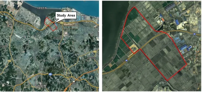
본 연구에서는 그림 1과 같이 충남 당진시 가곡리의 석문 간척지 일부지역을 연구대상지로 선정하였다. 농어촌공사에서는 석문간척지에 대 단위 농경지를 조성하여 지역주민들로부터 일정 량의 임대료를 받고 동물 사료용 작물인 총체벼 와 옥수수를 재배하도록 하고 있다. 그러나 해 당지역은 간척지를 개간한 것으로 일부 농경지 의 경우 염해로 인해 작물이 성장하지 못하는 지역도 많이 분포하고 있다. 따라서 식생지수의 평가를 통해 해당필지별로 작물의 생육상태를 정기적으로 모니터링할 필요가 있으며 이를 통 해 염해로 인해 생육이 저하된 작물을 포함하고 있는 필지에 대해서는 임대료를 할인해 주는 업 무도 지원할 필요가 있다. 따라서, 본 연구에서 는 석문 간척지 일부지역을 대상지로 선정하여 식생지수에 대한 정확도를 평가하고 향후 필지
별로 식생지수 현황과 염해피해 정도를 상호 비 교하는데 기초자료로 활용하고자 하였다.
3. 자료구축 및 식생지수 분석
본 연구에서는 자료구축을 위하여 2019년 8 월 7일과 9월 21일에 현지조사 및 UAV 촬영 을 실시하였다. 분광계를 활용한 현지조사시 정 확한 위치를 취득하기 위하여 GNSS 측량기를 활용하였으며 VRS(virtual references station) 방식으로 GRS80 TM 좌표를 취득하였다. VRS 측량은 정밀도 ±3~5㎝를 확보할 수 있으므로 UAV 촬영영상에서 해당 픽셀별 식생지수를 정 확하게 확인할 수 있다. 1차 조사시기인 8월 7 일에는 24점을 선정하였으며, 2차 조사시기인 9월 21일에는 23점을 선정하였다.
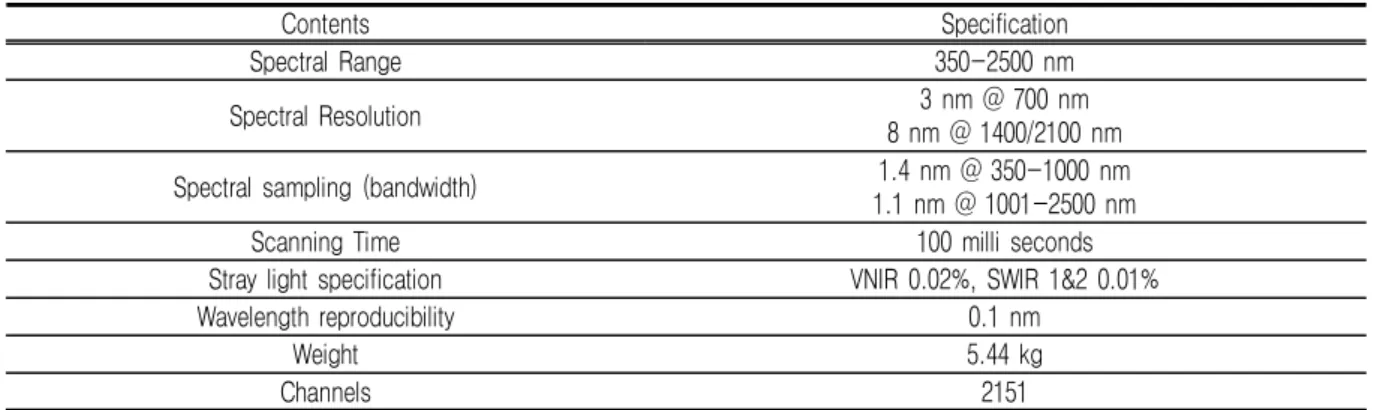
현지조사를 통한 식생지수 계산을 위해 표 2 의 ASD FieldSpec4 분광계를 활용하였으며, 현장조사 시점에 태양복사에너지의 특성을 고려 한 분광정보를 취득하기 위하여 전용복사판을 활용한 캘리브레이션을 실시하였다.
각 현장조사지점별로 식생지수에 활용되는 R, G, B, RE, NIR 밴드에 대한 반사율을 측정하고 해당 지점에 대한 GRS80 TM 좌표와 작물종류 그리고 사진 등을 정리하였으며 표 3은 대표적
FIGURE 1. Study Area
으로 여러 지점 중 벼를 재배하고 있는 지점에 대한 조사 내용을 보여준다.
또한 본 연구에서는 (주)케바드론의 KD-2 Mapper에 Micasense RedEdge 다중분광 카메 라를 장착하여 대상지역에 대한 R, G, B, RE, NIR 밴드별 분광특성 정보를 취득하였고
NDVI, NDRE, SAVI, GNDVI 식생지수를 산정 하였으며 조사지점에 식생지수를 추출하였다.
표 4는 Micasense RedEdge 다중분광 카메라 의 제원이다.
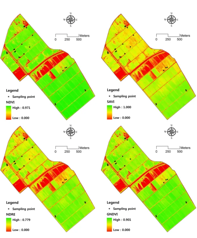
그림 2는 첫번째 조사시점인 8월 7일에 UAV를 이용하여 촬영된 분광정보를 이용하여
Contents Specification
Spectral Range 350-2500 nm
Spectral Resolution 3 nm @ 700 nm
8 nm @ 1400/2100 nm
Spectral sampling (bandwidth) 1.4 nm @ 350-1000 nm
1.1 nm @ 1001-2500 nm
Scanning Time 100 milli seconds
Stray light specification VNIR 0.02%, SWIR 1&2 0.01%
Wavelength reproducibility 0.1 nm
Weight 5.44 kg
Channels 2151
TABLE 2. Specification of spectrometer (ASD FieldSpec4)
Location(m) Reflectance
X(N) Y(E) R G B RE NIR
487244.7 169648.5 0.0240 0.0614 0.0227 0.1395 0.4276
TABLE 3. Field survey contents for sampling point (Crops: rice plant)
Contents Specification
Dimensions 8.7 cm × 5.9 cm × 4.54 cm
Spectral Bands Blue(475 nm), Green(560 nm), Red(668 nm), Red edge(717 nm), Nir(840 nm)
Ground Sample Distance 8 cm per pixel at 120 m
Capture Rate 1 cpature per second, 12-bit RAW
Field of view 47.2° HFOV
Weight 231.9 g
TABLE 4. Specification of Micasense Rededge camera
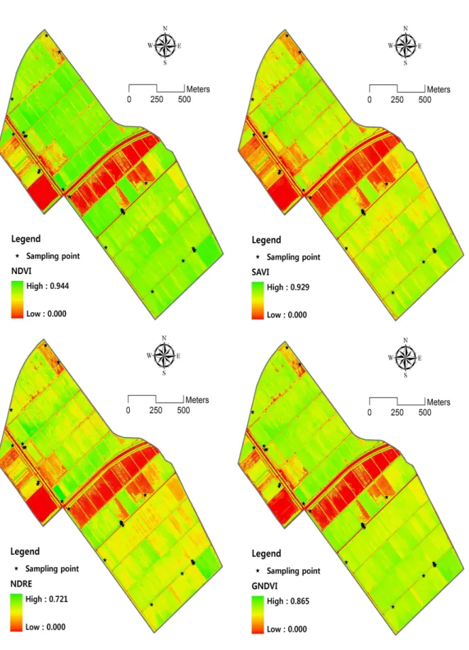
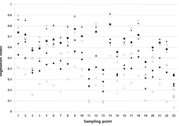
계산한 식생지수에 24개 현지조사지점을 나타 낸 결과이며 그림 3은 두 번째 조사시점인 9월 21일에 촬영된 분광정보를 이용하여 계산한 식 생지수 및 23개 현지조사지점을 나타낸 결과이 다. 또한 그림 4와 그림 5는 각각 1차 및 2차
현지조사에 의2하여 취득된 분광정보에 의하여 산정된 각 현지조사 지점의 식생지수 산정결과 와 UAV 촬영을 통하여 취득된 분광특성 정보 를 활용하여 계산한 각 현지조사 지점별 식생지 수 산정결과를 함께 나타낸 결과이다.
FIGURE 2. Vegetation indices calculated by multispectral image obtained by UAV (1st field survey)
FIGURE 3. Vegetation indices calculated by multispectral image obtained by UAV (2nd field survey)
FIGURE 4. Vegetation indices calculated by the 1st field survey
FIGURE 5. Vegetation indices calculated by the 2nd field survey
결과 및 고찰
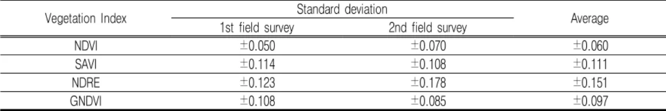
본 연구에서는 분광계를 이용하여 현지 조사 한 분광특성을 참값으로 가정했을 때 현지조사 에 의하여 취득된 분광정보를 이용하여 산정된 식생지수와 UAV 영상자료에 의하여 산정된 식 생지수간의 오차를 분석하기 위해 각 조사지점 별로 표준편차를 표 5와 같이 계산하였다.
1차 및 2차 조사결과에 대한 표준편차를 평 균한 결과 NDVI의 표준편차가 ±0.060로 가장 낮게 나타났으며 NDRE의 표준편차가 ±0.151 로 가장 높게 나타났으며 NDVI > GNDVI >
SAVI > NDRE 순으로 분석되었다.
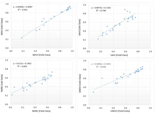
또한 분광계를 이용하여 현지 조사한 식생지 수와 UAV 영상자료에 의한 식생지수간의 회귀 분석을 실시하고 상관계수와 결정계수를 계산하 여 표 6에 제시하였다. 전체적으로 식생지수의 상관계수와 결정계수가 높게 나타나 현지조사 식생지수와 UAV 식생지수간에 유의미한 결과 를 보였으며, 특히 NDVI의 평균 상관계수가 0.984로 매우 높게 나타났다. 상관계수와 마찬 가지로 NDVI의 평균 결정계수가 0.968로 가장 높게 나타났으며 SAVI가 0.765로 가장 낮은 값을 보였다. NDVI 식생지수와 다른 식생지수 간의 표준편차의 차이에 비해 상관계수의 차이 가 크지 않은 것은 계산식의 차이에 따른 결과
로 해석된다.
그림 6과 7은 NDVI, SAVI, NDRE, GNDVI 에 대한 1차 및 2차 현지조사 식생지수와 UAV 식생지수간의 회귀분석 결과를 나타낸 것이다.
결 론
본 연구에서는 다중분광센서를 장착한 UAV 를 이용하여 간척지 농경지에 대한 다중분광영 상을 취득하고 대상지역에 대한 식생지수를 분 석하였다. 또한 정확도 평가를 위하여 분광계를 이용하여 주요지점에 대한 현지조사를 실시하였 고 현지조사에 의한 식생지수와 UAV 다중분광 영상으로부터 산정된 식생지수간의 상관성을 평 가함으로써 가장 적절한 식생지수를 도출하였다.
현지조사에 의하여 취득된 분광정보를 이용하 여 산정된 식생지수와 UAV 영상자료에 의하여 산정된 식생지수간의 조사지점별 표준편차를 분 석한 결과 NDVI의 표준편차가 ±0.060로 가장 낮게 나타났으며 NDVI, GNDVI, SAVI, NDRE 순으로 분석되었다. 또한, 분광정보 취득방법에 따른 식생지수간의 회귀분석을 실시하고 상관계 수와 결정계수를 계산한 결과 NDVI의 상관계수 와 결정계수가 가장 높게 나타났으며 모든 식생 지수에 대하여 전반적으로 상관계수와 결정계수 가 높게 나타나 현지조사 식생지수와 UAV 식
Vegetation Index Standard deviation
Average 1st field survey 2nd field survey
NDVI ±0.050 ±0.070 ±0.060
SAVI ±0.114 ±0.108 ±0.111
NDRE ±0.123 ±0.178 ±0.151
GNDVI ±0.108 ±0.085 ±0.097
TABLE 5. Standard deviation of vegetation indices
Vegetation Index Correlation coefficient Coefficient of determination 1st field survey 2nd field survey Average 1st field survey 2nd field survey Average
NDVI 0.980 0.987 0.984 0.961 0.975 0.968
SAVI 0.893 0.856 0.875 0.798 0.732 0.765
NDRE 0.925 0.967 0.946 0.856 0.936 0.896
GNDVI 0.921 0.976 0.949 0.848 0.952 0.900
TABLE 6. Result of regression analysis
FIGURE 6. Result of regression analysis between the 1st field surveyed vegetation index and UAV vegetation index
FIGURE 7. Result of regression analysis between the 2nd field
surveyed vegetation index and UAV vegetation index
생지수간의 유의미한 결과를 보이고 있으나 NDVI의 표준편차가 가장 낮게 나타난 것으로 볼 때 UAV 영상자료를 이용한 식생지수를 산 정하는 경우 NDVI가 현지조사 값을 기준으로 가장 높은 정확도를 나타냈다.
REFERENCES
Birth, G.S. and G.R. McVey. 1968.
Measuring the Color of Growing Turf with a Reflectance Spectrophotometer.
American Society of Agronomy, 60:640- 643.
Booth, D.T., S.E. Cox, T. Meikle and H.R.
Zuuring. 2008. Ground-cover measurements:
assessing correlation among aerial and ground-based methods. Environmental Management 42(6):1091-1100.
Broge, N.H. and J.V. Mortensen. 2002.
Deriving green crop area index and canopy chlorophyll density of winter wheat from spectral reflectance data.
Remote Sensing of Environment 81(1):
45-57.
Candiago, S., F. Remondino, M.D. Giglio, M.
Dubbini, and M. Gattelli. 2015. Evaluating Multispectral Images and Vegetation Indices for Precision Farming Applications from UAV Images. Remote Sensing 7:4026-4047.
Choi, Y.W., J.H. You and G.S. Cho. 2015.
Accuracy analysis of UAV data processing using DPW. Journal of the Korean Society for Geospatial Information Science 23(4):3-10 (최연웅, 유지호, 조기 성. 2015. DWP를 이용한 UAV 자료 처리의 정확도 분석. 한국지형공간정보학회 23(4):3 -10).
Dieter H., Z. Werner, S. Gunter, and S.
Peter. 2005. Monitoring of gas pipelines - a civil UAV application. Aircraft Engineering and Aerospace Technology 77:352-360.
Feng, Q., J. Liu, and J. Gong. 2015. UAV Remote Sensing for Urban Vegetation Mapping Using Random Forest and Texture Analysis. Remote Sensing 7:
1074-1094.
Flynn, K.F. and S.C. Chapra. 2014. Remote Sensing of submerged aquatic vegetation in a shallow Non-turbid river using an unmanned aerial vehicle. Remote Sensing 6:12815-12836.
Gitelson, A., Y.J. Kaufman and M.N.
Merzlyak. 1996. Use of a green channel in remote sensing of global vegetation from EOS-MODIS. Remote Sensing of Environment 58(3):289-298.
Hardisky, M. A., V. Klemas and R.M.
Smart. 1983. The influence of soil salinity, growth form, and leaf moisture on the spectral radiance of Spartina alterniflora canopies. Photogrammetric Engineering & Remote Sensing 49:77–83.
Hassan, F.M., H.S. Lim and M.Z. Mat Jafri.
2011. CropCam UAV for Land Use/Land Cover mapping over Penang Island, Malaysia, Pertanika Journal of Science &
Technology, 19:69-76.
Herwitz, S.R., L.F. John, S.E. Dunagan, R.G. Higgins, D.V. Sullivan, J. Zheng, B.M. Lobitz, J.G. Leung, B.A. Gallmeyer, M. Aoyagi, R.E. Slye and J.A. Brass.
2004. Imaging from an unmanned aerial vehicle: agricultural surveillance and decision support, Computers and Electronics in Agriculture 44:49-61.
Hornbuckle, J., J. Brinkhoff, C. Ballester and S. North. 2016, Using Satellite And Drones For Water And Nitrogen Management Decision Making, CRDC.
Hong, S.Y., J.N. Hur, J.B. Ahn, J.M. Lee, B.K. Min, C.K. Lee, Y.H. Kim, K.D. Lee, S.H. Kim, G.Y. Kim, and K.M. Shim.
2012. Estimating rice yield using MODIS NDVI and meteorological data in Korea.
Korean Journal of Remote Sensing 28(5):509-520 (홍석영, 허지나, 안중배, 이지민, 민병걸, 이충근, 김이현, 이경도, 김선 화, 김건엽, 심교문. 2012. MODIS NDVI와 기상자료를 이용한 우리나라 벼 수량 추정.
한국원격탐사학회지 28(5):509-520).
Huete, A.R. 1988. A soil-adjusted vegetation index(SAVI). Remote Sensing of Environment 25(3):259-309.
Huete, A.R. and H.Q. Liu. 1994. An error and sensitivity analysis of the atmospheric- and soil-correcting variants of the NDVI for the MODIS-EOS. IEEE Transactions on Geoscience and Remote Sensing 32(4):897-905.
Hunt, E.R., J.H. Everitt, J.C. Ritchie, M.S.
Moran, D.T. Booth, G.L. Anderson, P.E.
Clark and M.S. Seyfried. 2003.
Applications and research using remote sensing for rangeland management.
Photogrammetric Engineering & Remote Sensing 69(6):675-693.
Im, S.H., S.I. Hassan, L.M. Dang, K.B. Min and H. Moon. 2018. Analysis of Fusarium Wilt Based on Normalized Difference Vegetation Index for Radish Field Images from Unmanned Aerial Vehicle. The Transactions of the Korean Institute of Electrical Engineers 67(10):
1353-1357 (임수현, Syed Ibrahim Hassan, Lien Minh Dang, 민경복, 문현준. 2018. 무 인기로 촬영한 무 재배지 영상의 정규식생지 수(NDVI)를 활용한 병충해 분석 연구. 전기 학회논문지 67(10):1353-1357).
Jeong, S.H., Y.W. Choi and G.S. Cho. 2018.
Basic Data Investigation Method of Crop Insurance using Spatial Information Based on UAV. Journal of the Korean Society for Geospatial Information Science 26(3):61-68 (정승현, 최연웅, 조기성. 2018.
무인항공기 기반 공간정보를 활용한 농작물보 험 기초자료 수집기법 연구. 대한공간정보학 회지 26(3):61-68).
Jung, K.S., Y.S. Kim, and S.R. Oh. 2015.
Technical Development of Flood Damage Estimation using UAV. Water for future, 48(1):51-59 (정관수, 김연수, 오성렬.
2015. UAV를 활용한 홍수피해산정 기술 개 발. 물과 미래 48(1):51-59).
Kim, D.I., Y.S. Song, G. Kim, and C.W.
Kim. 2014. A study on the application of UAV for korean land monitoring. Journal of the Korean Society of Surveying, Geodesy, Photogrammetry and Cartography 32(1):29-38 (김덕인, 송영선, 김기홍, 김창 우. 2014. 무인항공기의 국토모니터링분야 적용을 위한 연구. 한국측량학회지 32(1):
29-38).
Kim, K.Y. and S.I. Na. 2019. Vegetation Map Service System Using UAV Imagery and Sample Field Data on Major Cultivation Regions. Journal of the Korean Society for Geospatial Information Science 27(1):33-41 (김계영, 나상일. 2019. UAV 영상분석 및 현장조사 자료를 연계한 채소주 산지 재배현황맵 서비스 시스템. 대한공간정 보학회지 27(1):33-41).
Laliberte, A.S., A. Rango, J.E. Herrick, E.L.
Fredrickson and L. Burkett. 2007. An object-based image analysis approach for determining fractional cover of senescent and green vegetation with digital plot photography. Journal of Arid Environments 69(1):1-14.
Lee, K.D., S.I. Na, S.C. Baek, K.D. Park, J.S. Choi, S.J. Kim, H.J. Kim, H.S. Yun, and S.Y. Hong, 2015, Estimating the amount of nitrogen in hairy vetch on paddy fields using unmaned aerial vehicle imagery, Korean Journal of Soil Science and Fertilizer 48(5):384-390 (in Korean with English abstract).
Lee, K.D., Y.E. Lee, C.W. Park, S.Y. Hong and S.I. Na. 2016. Study on Reflectance and NDVI of Aerial Images using a Fixed-Wing UAV“Ebee”. Korean Journal of Soil Science and Fertilizer 49(6):731 -742 (in Korean with English abstract).
Lee, G.S., Y.W. Choi, K. Jung and G.S.
Cho. 2015. Analysis of the Spatial Information Accuracy According to Photographing Direction of Fixed Wing UAV. Journal of the Korean Cadastre Information Associstion 17(3):141-149 (이근상, 최연웅, 정관수, 조기성. 2015. 고정 익 UAV의 촬영방향에 따른 DEM 및 정사영 상 제작 정확도 분석. 한국지적정보학회지 17(3):141-149).
Lee, G.S., Y.W. Choi, S.B. Lee and S.G.
Kim. 2016. Estimation of reservoir area and capacity curve equation using UAV photogrammetry. Journal of the Korean Society for Geo-spatial Information Science 24(3):93-101 (이근상, 최연웅, 이 석배, 김석구. 무인항공기 사진측량에 의한 저수면적과 저수량 곡선식 산정. 대한공간정 보학회지 24(3):93-101).
Lee, J.W., G.A. Park, H.K. Joh, K.H. Lee, S.I. Na, J.H. Park, and S.J. Kim. 2011.
Analysis of relationship between vegetation indices and crop yield using KOMPSAT (KoreaMulti-Purpose SATellite)-2 imagery and field investigation data. Journal of The Korean Society of Agricultural Engineers 53(3):75-82 (이지완, 박근애, 조형경, 이규호, 나상일, 박종화, 김성준.
2011. KOMPSAT-2 위성영상과 현장 측정 자료를 통한 식생지수와 수확량의 상관관계 분석. 한국농공학회논문집 53(3):75-82).
Morel, A. and L. Prieur. 1977. Analysis of variation in ocean. Limnology and Oceanography 22:709-722.
Na, S.I., S.Y. Hong, C.W. Park, K.D. Kim, K.D. Lee. 2016. Estimation of highland Kimchi cabbage growth using UAV NDVI and agro-meteorological factors. Korean Journal of Soil Science and Fertilizer 49(5):420-428 (in Korean with English abstract).
Na, S.I., S.Y. Hong, Y.H. Kim, K.D. Lee, and S.Y. Jang. 2013. Prediction of rice yield in Korea using paddy rice NPP index: Application of MODIS data and CASA model. Korean Journal of Remote Sensing 29(5):461-476 (나상일, 홍석영, 김이현, 이경도, 장소영. 2013. 논벼 NPP 지 수를 이용한 우리나라 벼 수량 추정, 한국원 격탐사학회지 29(5):461-476).
Na, S.I., C.W. Park, Y.K. Cheong, C.S.
Kang, I.B. Choi and K.D. Lee. 2016.
Selection of Optimal Vegetation Indices for Estimation of Barley & Wheat Growth based on Remote Sensing: An Application of Unmanned Aerial Vehicle and Field Investigation Data. Korean Journal of Remote Sensing 32(5):483-
497 (나상일, 박찬원, 정영근, 강천식, 최인 배, 이경도. 2016. 원격탐사 기반 맥류 작황 추정을 위한 최적 식생지수 선정. 한국원격탐 사학회지 32(5):483~497).
Nam W.H., T. Tadesse, B.D. Wardlow, M.W. Jang and S.Y. Hong. 2015. Satellite -based hybrid drought assessment using vegetation drought response index in South Korea (VegDRISKorea). Journal of the Korean Society of Agricultural Engineers 57(4):1-9 (남원호, 장민원, 홍 석영. 2015. 식생가뭄반응지수(VegDRI)를 활용한 위성영상 기반 가뭄 평가. 한국농공학 회논문집 57(4):1-9).
Pajares, G. 2015. Overview and current status of remote sensing applications based on unmanned aerial vehicles (UAVs). Photogrammetric Engineering &
Remote Sensing 81(4):281-329.
Park, J.K. and J.H. Park. 2015. Crops classification using imagery of unmanned aerial vehicle(UAV). Journal of the Korean Society of Agricultural Engineers 57(6):91-97 (박진기, 박종화. 무인비행기 (UAV) 영상을 이용한 농작물 분류. 한국농 공학회논문집 57(6):91-97).
Pearson, R.L. and L.D. Miller. 1972. Remote mapping of standing crop biomass for estimation of the productivity of the shortgrass prairie. Proceeding of the Eighth International Symposium on Remote Sensing of Environment, II, Michigan, Ann Arbor, pp. 1357-1381.
Rock, B.N., J.E. Vogelmann, D.L. Williams, A.F. Vogehnann and T. Hoshizaki. 1986.
Remote detection of forest damage.
Bioscience 36:439-445.
Rouse, J,W., R.H. Haas, J.A. Schell and
D.W. Deering. 1974. Monitoring Vegetation Systems in the Great Plains with ERTS.
Proceedings, Third Earth Resources Technology Satellite-1 Symposium, Volume 1: Technical Presentations, section A.
pp.309-317.
Shin, Y.H., J.H. Park and M.S. Park. 2003.
Spectral reflectance characteristics and vegetation indices of field crops. KCID journal 10(2):43-54 (신용희, 박종화, 박민 서. 밭작물의 분광반사 특성과 식생지수. 한 국관계배수 10(2):43-54).
Su, T.C. and H.T. Chou. 2015. Application of multispectral sensors carried on unmanned aerial vehicle(UAV) to trophic state mapping of small reservoirs: A case study of Tain-Pu reservoir in Kinmen, Taiwan. Remote Sensing 7(8):
10078-10097.
Toevs, G.R., J.W. Karl, J.J. Taylor, G.S.
Spurrier, M. Karl, M.R. Bobo and J.E.
Herrick. 2011. Consistent indicators and methods and a scalable sample design to meet assessment, inventory, and monitoring information needs across scales. Rangelands 33:14-20.
Tomas, J.R. and H.W. Gausman. 1977. Leat reflectance vs. leaf chlorophyll and carotenoid concentrations for eight crops. Agronomy Journal 69:799-802.
Thompson, L.J., Y. Shi, R.B. Ferguson.
2017. Getting Started with Drones in Agriculture. NebGuide, Nebraska Extension Publications. 12pp.
Watanabea, Y. and Y. Kawaharab. 2016.
UAV photogrammetry for monitoring changes in river topography and vegetation. Procedia Engineering 154:317
-325.
Zaman, B., A. Jensen, S.R. Clemens and M.
McKee. 2014. Retrieval of spectral reflectance of high resolution multispectral
imagery acquired with an autonomous unmanned aerial vehicle. Photogrammetric Engineering & Remote Sensing 80(12):
1139–1150.