S-100 기반의 항로정보 데이터 모델 설계에 관한 연구
박병문
1·김재명
2※·최윤수
3·오세웅
4·정민
5A Study on the Design of Data Model for Route Information based on S-100
Byung-Moon PARK
1·Jae-Myeong KIM
2※·Yun-Soo CHOI
3Se-Woong OH
4·Min JUNG
51
요 약
우리나라는「해사안전법」에 따라 교통안전특정해역 5개소, 통항분리방식 3개소, 지방해양수산 청 고시 26개 등 총 34개의 항로가 지정되어 있으며, SOLAS 협약에서는 항로의 안전을 위해 항 로정보가 효과적으로 사용될 수 있도록 규정하고 있다. 항로정보는 항로의 위치, 항로별 항법, 운 항제한, 정박지 등 복잡하게 구성되어 있어서, 해도와 항로지를 이용하여 정보를 제공하는 현재의 방법은 항로 이용자가 정보를 신속하게 파악하기 어렵다. 본 연구는 항로정보를 보다 효과적으로 제공할 수 있는 방법을 찾기 위해 국제수로기구가 개발한 S-100 기반의 항로정보 데이터 모델 설계에 관한 연구를 수행하였다. 이를 위해 항로정보에 대한 요구 분석, 항목 선정, 인코딩 테스트 단계의 연구를 수행하였으며, 연구 내용에 대한 전문 사용자 검토를 거쳤다. 전문 사용자 검토에서 는 항로정보 데이터 모델 설계에 대한 연구가 항로정보 통합 서비스 등에 좋은 기초자료가 될 것 이라는 평가를 얻었으며, 향후 항로정보 데이터 모델 개발에 대한 후속 연구가 진행된다면 항로정 보 통합 서비스가 가능할 것이라고 판단된다.
주요어 : S-100, 범용수로데이터모델, 항로, 항로정보
ABSTRACT
According to the Maritime Safety Act, there are all 34 routes including 5 traffic safety zones, 3 traffic separation schemes, 26 routes designated by regional maritime
2019년 03월 06일 접수 Received on March 06, 2019 / 2019년 5월 30일 수정 Revised on May 30, 2019 / 2019년 05월 30일 심사완료 Accepted on May 30, 2019
1 서울시립대학교 공간정보공학과 Dept. of Geoinformatics, University of Seoul, Seoul, Korea 2 서경대학교 도시공학과 Dept. of Urban Planning & Engineering, Seokyeong University 3 서울시립대학교 공간정보공학과 Dept. of Geoinformatics, University of Seoul, Seoul, Korea
4 선박해양플랜트연구소 해양안전환경연구부 Maritime Safety and Environmental Research Division, Korea Research Institute of Ships & Ocean Engineering (KRISO), Daejeon, Korea
5 한국해양수산연수원 교육본부 Future Policy Planning Team, Korea Institute of Maritime and Fisheries Technology (KIMFT), Busan, Korea
※ Corresponding Author E-mail : [email protected]
affairs departments in the Republic of Korea. In the SOLAS convention, the route information should be is effectively used for the safe navigation. However, the route information is complicatedly composed of the location of the route, the navigation rule by each route, the restriction of the navigation, and the anchorages. Moreover, the present method of providing information using the navigational chart and other publications is not effective for users to grasp the navigational information. Therefore, it was conducted to study the design of the S-100 based routing information data model developed by the International Hydrographic Organization to find ways to more effectively provide route information. To do this, the analysis of route requirement, selection of items, encoding test and users’review were carried out. Through expert user review, it was evaluated that the study on the design of the route information data model can be utilized as a good basic data for the route information integration service.
Future research on the development of route information data models is expected to provide integrated route information services.
KEYWORDS : S-100, Universal Hydrographic Data Model, Route, Route Information
서 론
우리나라에는「해사안전법」에 따라 교통안 전특정해역 5개소, 통항분리방식 3개소, 지방해 양수산청 고시 26개 등 총 34개 항로가 지정 되어 있다(MOF, 2015).
우리나라 연안은 복잡한 해안선과 많은 도서 가 산재하여 있으며, 빠른 유속과 큰 조차 그리 고 빈번히 해무가 발생하는 등 자연환경이 열 악하고, 연근해 양식장, 어로활동 등으로 인하 여 항해 위험요소가 산재하고 있다(KHOA, 2016a). 또한 최근 항로를 이용하는 선박의 통 항이 많고1)(MOF, 2017), 항로 주변의 해양사 고가 꾸준히 증가하는 추세2)(KMST, 2017)를 보이고 있어서 항로에 대한 관심이 필요한 때 이다.「해상에서의 인명안전을 위한 국제협약 (이하 SOLAS 협약)」에서도 항로에 대하여 제5장에 별도의 규정을 두고 있으며, 당사국 정 부는 선박 항로의 효과적인 사용에 필요한 모 든 정보를 공표하여야 한다(KR, 2012)고 명시 되어 있다. 이것은 항로의 안전을 매우 중요하 며, 항로정보가 효과적으로 사용될 수 있도록 해야 한다는 것을 명확하게 한 것이라고 해석 할 수 있다.
이 논문에서는 항로정보를 효과적으로 제공 할 수 있는 통합 서비스 방안을 찾기 위해 S-100 기반의 항로정보 데이터 모델의 설계 방안을 도출하고자 하였다.
S-100 표준 및 관련 제품 표준
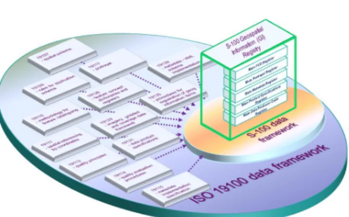
1. S-100 표준 개요
S-100(범용 수로 데이터 모델)은 차세대 전자해도 뿐만 아니라 수로 분야, 해사 분야, GIS 커뮤니티에서 필요로 하는 전자적 제품 개 발을 위한 데이터 프레임워크를 제공하는 표준 으로, 그림 1과 같이 ISO의 지리공간 표준인 19100 시리즈 표준을 수로 분야로 확장한 표 준이다. 국제수로기구(이하 IHO)에서 전자해도 제품인 S-57 표준이 가지는 문제점을 보완하 기 위해 다양한 요구사항을 반영하여 S-100 표준을 개발하였으며, 2015년 6월에 S-100 2.0 버전을 발표하였고(HSK, 2017), 2018년 11월에 4.0 버전이 마련되었다.
2. S-100 표준을 이용한 제품 표준
IHO는 S-100 4.0 표준을 기반으로 S-101 차세대 전자해도 표준을 포함하여 다양한 수로
분야 제품 표준개발을 진행 중에 있다. 또한 S-100 표준이 가지고 있는 해양정보 전송에 관한 우수한 특징을 높이 평가하여 국제항로표 지협회, 세계기상기구 등의 국제기구에서 S- 100 표준 기반의 제품 표준을 개발 중에 있다.
다음 표 1은 IHO에서 개발 주인 S-100 기반 제품 표준 목록이다(HSK, 2017).
우리나라의 항로 현황 및 항로정보 제공방법의 한계
1. 우리나라의 항로 현황
우리나라에는 교통안전특정해역 5개소, 통항 분리방식 3개소, 지방해양수산청 고시항로 26 개 등 총 34개의 항로가 지정되어 있다. 그림 2는 각 항로의 위치이다(MOF, 2015). 그림 2 와 같이 우리나라 항로의 대부분은 서해안, 남 해안의 연안에 위치해 있으며, 무역항을 입‧출항 하는 통로로 사용되고 섬이 많은 자연적 조건 으로 항로의 폭이 좁은 경향을 보인다.
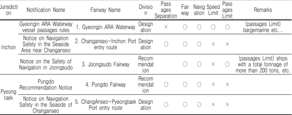
표 2는 지방해양수산청 고시항로의 현황이다 (MOF, 2015). 지방해양수산청의 고시항로의 FIGURE 1. Overview of S-100 profile conept from ISO
19100 data framework
Standard Implementation details Remarks
S-101 Electronic Navigational Chart(ENC)
S-102 Bathymetric Surface
S-104 Tidal Information for Surface Navigation
S-111 Surface Currents
S-112 Dynamic Water Level Data Product Specification
S-121 Maritime Limits and Boundaries
S-122 Marine Protected Areas
S-123 Radio Services
S-124 Navigational Warnings
S-125 Navigational Services
S-126 Physical Environment
S-127 Traffic Management
S-1xx Marine Servies
S-1xx Digital Mariners’ Routeing Guide
S-1xx Harbour Infrastructure
TABLE 1. S-100 based product specifications
FIGURE 2. The location map of routes in Korea
Jurisdicti
on Notification Name Fairway Name Divisio
n Pass ages Separation
Fair way Navig ation Speed
Limit Pass ages
Limit Remarks
Inchon
Gyeongin ARA Waterway
vessel passages rules 1. Gyeongin ARA Waterway Design
ation × ○ ○ ○ ○ (passages Limit)
bargemarine etc...
Notice on Navigation Safety in the Seaside Area near Changanseo
2. Changanseo-Inchon Port entry route Design
ation ○ ○ ○ × ×
Notice on the Safety of
Navigation in Joongsudo 3. Joongsudo Fairway Recom mendat
ion ○ ○ × ○ (passages Limit) ships
with a total tonnage of more than 200 tons, etc.
Pyeong taek
Pungdo
Recommendation Notice 4. Pungdo Fairway Recom mendat
ion ○ ○ ○ × ×
Notice on Navigation Safety in the Seaside of
Changanseo
5. ChangAnseo-Pyeongtaek Port entry route Design
ation ○ ○ ○ × ×
TABLE 2. Current Status of Regional Office of Oceans and Fisheries’s route notifications
Jurisdicti
on Notification Name Fairway Name Divisio
n Pass ages Separation
Fair way Navig
ation Speed Limit
Pass ages
Limit Remarks
Daesan (Ongdo Route) Notice on Navigation Safety 6. Ongdo Fairway Design
ation ○ ○ ○ × ×
Mokpo
(Navy Area near Mokpo) Notice on Navigation
Safety
7. Mokpo-gu/Sia
Sea/Jeong-dong Fairway Design
ation ○ ○ × ○ Cross voyage Banning in
vessel constrained by the draught When Visibility Is
Restricted 8. Deep water depth Fairway Design ation ○ ○ × ○
(Maemulsudo etc.) Notice on navigational
safety
9. North Maemulsudo
Fairway Design
ation ○ ○ ○ ○ × boundary waters,
navigational self-restraint, etc 10. South Maemulsudo
Fairway Design
ation ○ ○ ○ ○ ×
(Hongdo and Huksando shore region) Notice on
navigational safety
11. First Route of Hongdo Design
ation ○ ○ ○ × ×
12. Second Route of
Hongdo Design
ation ○ ○ × ×
13. Huksan Fairway Design
ation ○ ○ × ×
14. Huksan/Hongdo Fairway Design ation ○ ○ ○ × × (Wando Port) Notice on
navigational safety 15. Wando Port Access and Crossing Route Design
ation ○ ○ ○ Application of the
Customs Separation System
(The shore region near Wando) Notice on navigational safety
16. Hoenggansudo Fairway Recom mendat
ion ○ ○ × × Designating boundary
waters near other Huksando and
Hoenggando 17. Sodeok-Udo Fairway Recom
mendat
ion ○ ○ × ×
Masan
Notice on Navigation Safety in Jinhae bay and
near waters
18. Masan Fairway Design
ation ○ ○ ○ ○ ×
Include speed limit zones and caution areas (stable route) Restricting
access within a 1 km radius of the LNG carrier,
etc.
19. Tongyeong Fairway Design
ation ○ ○ ○ ○ ×
20. Jinhae Fairway Design
ation ○ ○ ○ ○ ×
21. Anjeong Fairway Design
ation ○ ○ ○ ○
Notice on Navigation Safety in the near waters
Nashan of district of Goseong Shipbuilding
Industry
22. Naesan Fairway Design
ation ○ ○ × ×
Notice on Navigation Safety in the near waters
of Jangjwa district in Goseong County
23. Jangjwa Fairway Design
ation ○ ○ × × Specify some
no-holdings areas (Geoje-Samcheonpo
Inlandseas Waterway) notice on navigational
safety
24. Geoje-Samcheonpo Inlandseas Waterway
Recom mendat
ion ○ ○ × ×
Recommendation for curfews, such as tankers,
and establishment of cautionary sea areas, etc.
Busan New Port Navigation and notice on navigational
safety
25. Busan New Port Entry and Exit and the Cautionary
Sea ara
Design
ation ○ ○ ○ ○ × Caution route speed limit
Pohang (Homigot) Notice on
Ship Navigation Safety 26. Recommendation for Homigot
Recom mendat
ion ○ ○ ○ × × Application to ships with
a total tonnage of 1,000
tons or more
TABLE 2. Continued내용을 살펴보면, 항로와 관련되는 정보는 항로 의 구분, 통항분리 여부, 항로의 위치, 각 항로 별 항법, 속력 제한, 통항 제한 등을 포함하고 있다. 그리고 각 항로에 따라 포함 내용이 다름 을 알 수 있다.
2. 항로정보 제공 방법의 한계
항해자에게 제공하는 해도 및 항해용 간행물 은 SOLAS 협약 제5장 제2조에 따라 IHO의 결의서 및 권고를 적절하게 참조하여 각국의
수로국 또는 정부기관을 대신하여 공식적으로 발행한“해도 및 항해용간행”이라고 정의되어 있다(KR, 2012). 항로정보를 제공하기 위해 해도와 항해용 간행물의 하나인 항로지가 사용 되고 있다.
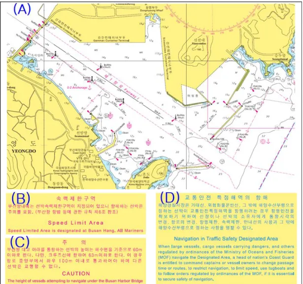
그림 3은 부산항 부근 해도에 수록된 항로정 보를 표시한 것으로 (A)는 항해에 직접 이용되 는 해상부분으로 항로 관련 정보는 항로의 위 치와 명칭이 표시되어 있다. (B)와 (C)는 속력 제한구역, 부산항 대교 통과 높이에 대한 주의
FIGURE 3. Route informations on the nautical chart
사항에 대한 내용이며, (D)는 교통안전특정해 역의 항해에 대한 설명이 표시되어 있다. 항해 에 이용되는 해도에는 여백이 많이 않기 때문 에 항로에 관한 정보를 수록할 수 없는 한계가 있다.
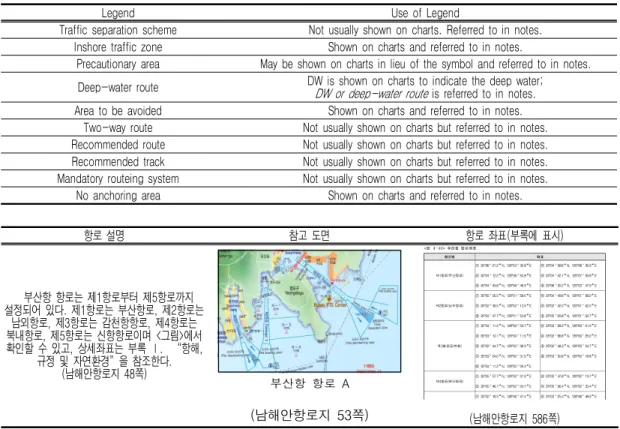
항로에 관한 정보를 해도에 표현하는 한계성 은 국제해사기구(이하 IMO)의 항로지정 규정 에도 반영되어 있는데, 표 3은 IMO에서 규정하 고 있는“해도 상에 항로정보의 표현”에 대한 권고내용이다(KHOA, 2017b). 이 권고 내용에 따르면 연안 통항대, 경계 해역, 깊은 수심 항 로, 피항 해역 등을 제외하고는 항로에 관한 정 보를 해도에 표시하지 않도록 권고 하고 있다.
이것은 해도에는 매우 제한적인 항로정보만을 표시할 수 있다는 것을 의미한다.
그림 4는 우리나라 남해안항로지의 내용 중
에서 항로에 관한 사항을 표시한 것으로, 항로 에 대하여 항로를 설명하는 부분과 항로 현황 을 파악할 수 있도록 참고도면이 수록되어 있 으며, 항로의 좌표는 부록에 수록되어 있다.
해도 상에서 항로의 위치를 파악하고 항로에 대한 세부적인 정보를 항로지에서 찾는 현재의 방법은 항로정보를 효과적으로 파악하는데 많 은 시간과 노력 그리고 정확한 정보파악에 기 술적 한계가 있음을 알 수 있다. 이러한 문제점 을 개선하는 방법은 위치정보와 속성정보가 결 합된 공간정보기술을 이용하는 것이 바람직하 며, S-100 표준을 기반으로 하는 항로정보 데 이터 모델이 개발된다면 S-100 전자해도인 S-101과 결합이 가능하고, 항로정보 통합 서 비스 환경이 만들어 질 수 있다고 판단된다.
항로 설명 참고 도면 항로 좌표(부록에 표시)
부산항 항로는 제1항로부터 제5항로까지 설정되어 있다. 제1항로는 부산항로, 제2항로는
남외항로, 제3항로는 감천항항로, 제4항로는 북내항로, 제5항로는 신항항로이며 <그림>에서 확인할 수 있고, 상세좌표는 부록 Ⅰ. “항해,
규정 및 자연환경”을 참조한다.
(남해안항로지 48쪽)
부산항 항로 A
(남해안항로지 53쪽)
(남해안항로지 586쪽)
FIGURE 4. Route informations on the pilot
Legend Use of Legend
Traffic separation scheme Not usually shown on charts. Referred to in notes.
Inshore traffic zone Shown on charts and referred to in notes.
Precautionary area May be shown on charts in lieu of the symbol and referred to in notes.
Deep-water route DW is shown on charts to indicate the deep water;
DW or deep-water route
is referred to in notes.
Area to be avoided Shown on charts and referred to in notes.
Two-way route Not usually shown on charts but referred to in notes.
Recommended route Not usually shown on charts but referred to in notes.
Recommended track Not usually shown on charts but referred to in notes.
Mandatory routeing system Not usually shown on charts but referred to in notes.
No anchoring area Shown on charts and referred to in notes.
TABLE 3. Legend of the expression of the chart and notes
항로정보 데이터 모델 설계
1. S-100 기반의 제품 표준의 개발 과정 S-100 표준을 기반으로 하는 제품 표준의 개발과정은 그림 5와 같이 6단계로 요약할 수 있다. 1단계에서는 사용자 요구사항을 파악한 다. 데이터와 데이터베이스에 대한 사용자 요구 사항을 수집하고 분석하여 2단계인 데이터 모
델링을 진행한다. 데이터 모델링의 과정은 ISO 19109 표준에서 정의한 데이터 변환 프로세스 에 따라 현실세계의 정보를 피처로 정의하고 피처 카탈로그를 만든다. 3단계는 피처 정보를 통해 UML로 표현된 응용 스키마를 작성하여 데이터 구조를 표현하며, 인코딩 과정을 거쳐, 4단계인 XML/GML 형태의 문서로 작성한다.
5단계는 IHO에서 관리하는 피처 레지스트리에 등록하고 6단계 제품 사양과 피처의 검증과정
FIGURE 5. 6 phases of development of S-100 based product specification
FIGURE 6. A mariners’routeing guide map made by UKHO
을 거친 후 표준이 만들어 진다(Kim et al., 2017).
본 연구에서는 S-100 기반의 제품 표준의 개발 단계에서 1단계 사용자 요구분석, 2단계 데이터 모델링, 3단계 인코딩 테스트까지를 수 행하였다.
2. 사용자 요구분석(항목 선정)
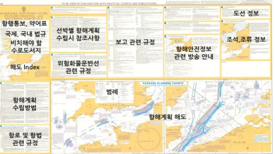
사용자 요구분석 단계에서는 항로정보 항목 을 선정하였다. 항로정보는 IHO에서 별도의 규 정으로 제공하고 있는 항해자용 항로지침 표준 인 S-49 표준을 참고하였다. S-49는 항해자 가 해도와 연계하여 항해계획 수립에 필요한 항로, 항법, 통항, 무선보고, 선박도선 등의 정 보가 수록된 도면에 대한 표준이다(KHOA, 2016b). 그림 6은 S-49 표준에 따라 영국 수 로국에서 제작한 도면이다. 표 4는 S-49 표준 에서 추천하는 항로정보 분류 기준이다.
항로정보 데이터 모델 설계를 위한 항목은 S-49 표준과 항로에 관한 고시 내용을 참고 하였으며, 항로정보 데이터 모델 설계를 위해 문헌 분석과 전문가 의견 조회를 통해 항로정 보 데이터 모델에 포함할 수 정보로 항로정보, 정박지, 금지해역, 항법정보, VTS 관련 정보를 구분하고, 표 5와 같이 항로정보 항목을 선정하 였다.
3. 데이터 모델링
항로정보에 대해 피쳐 및 정보 유형 식별 결 과를 토대로 데이터 모델을 설계 하였다. 본 데 이터 모델은 S-100 공통 피쳐 모델에 기반하 여 피쳐 기반 벡터 제품 개발을 고려하여 설계 하였다. 항로 데이터 모델의 모든 피쳐 및 정보 유형 클래스는 피쳐 및 정보 유형의 추상 클래 스(Abstract classes)에서 상속 받는데 이 추 상 클래스는 공통 피쳐 모델의 피쳐와 정보 유
Subject Essential information Useful information Not appropriate
information
Plan of the area (grahics)
Routeing measures Major Aids to Navigation Waring that plans Legend (key or symbols) Pilot boarding places Point where radio reporting Traffic surveillance stations
Selected depth contours All significant Aids to Navigation Positions and name of Rescue Center Ferry crossings
Traffic flow Heavy fishing Radar Surveillance
Soundings
Detailed of local Aids to Navigation
Coast radio stations
Passage planning (textual)
IMO-approved Rules Specific advice Underkeel clearance
General planning principles Verbatim wording
Routeing (textual)
IMO-adopted Special Provisions National rules and recommendations
Selected quotations Quatations (COLREG)
Two-way radio communications GMDSS Communica
-tions (textual)
Vessel reporting systems Broadcast information services
Maritime assistance service Maritime safety information Weather forcast areas NAVTEX areas Pilotage
(textual)
Compulsory pilotage information Contact and Boarding area information Helicopter boarding guidance
Natural environment
Tidal height
Currrents and tidal streams
Visibility Restrictions
Ice information
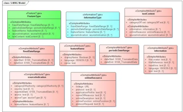
TABLE 4. Recommended contents of S-49형 클래스는 사용한 것이다. 항로정보 데이터 모델은 S-100 기반의 항해자용 항로 정보라는 의미를 담아 S-MRG(Mariner Routeing Guide)로 하였다.
그림 7은 항로정보 데이터 모델에 대한 기본
모델로서, S-100 공통 피처 모델에 상속받은 피처 유형과 정보 유형을 나타낸 그림이다. 항 로정보 데이터 모델은 여기에서 정의된 피처 유형과 정보 유형으로부터 상속 받아 세부적은 내용을 구성한다.
No Items Remarks
1 Two-way ship routing
Route Informations
2 one-way ship routing
3 Deep water route
4 Passage separation zones
5 Anchorage area Anchorage Areas
6 Restricted area navigational
Restricted Areas
7 Quarantine place
8 Speed regulation area
9 Cruiser flight prohibition
10 Traffic Safety Special Offshore
11 Oil tanker port forbidden zone
12 Navigation Regulations
13 Pilot boarding place Pilot boarding place
14 Vessel traffic control area Vessel traffic service areas
15 VTS Reporting Branch Radio calling-in point
TABLE 5. Items of route information
FIGURE 7. Route information data base model
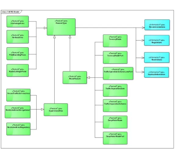
그림 8은 항로정보 데이터 모델의 전체 개요 도로서, 모든 피쳐 유형은 공통 피쳐 유형에서 상속받은 피처 유형과의 상속 관계를 가진다.
또한 각 피쳐 유형에 항법에 관한 정보를 포함 하기 위해 정보 유형과의 연계 관계를 설정하 였다. 항법 정보는 권고사항, 규정 사항, 제한사 항, 항해정보 사항으로 구분하여 정보 유형 형
식으로 데이터 모델에 반영하였다.
4. 인코딩 테스트
항로정보 데이터 모델에 대한 실험 데이터는 부산항을 대상으로 고시 내용, 전자해도, 항로 지 자료를 참고하여 제작하였다. 우선 부산항 FIGURE 8. A full overview of the S-MRG data model
Port name Route name Coordinats Remarks
Busan port 1
stFairway (Busan port)
The sea surface of a line that connects the points of each of the following subparagraphs sequentially:
1. N 35-06-21.2 E 129-03-39.8 2. N 35-04-38.6 E 129-06-35.9 3. N 35-04-12.2 E 129-06-50.8 4. N 35-04-42.1 E 129-07-09.8 5. N 35-04-45.8 E 129-06-46.9 6. N 35-06-30.2 E 129-03-47.9
TABLE 6. Coordinates of 1st Fairway in Busan port
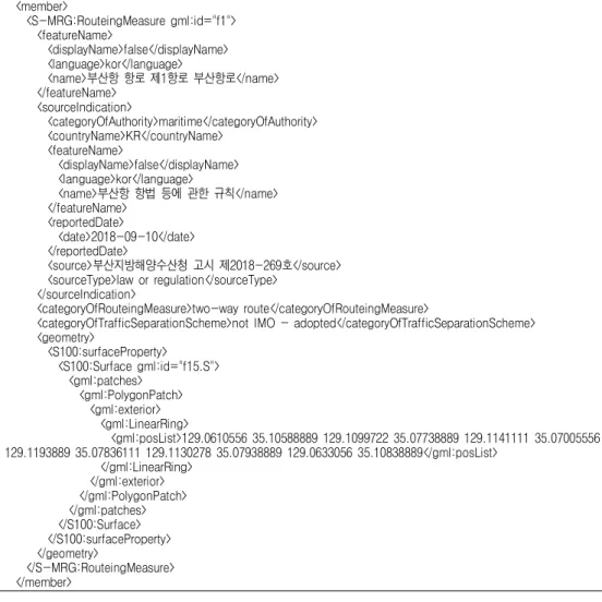
고시, 정박지 부분에 대한 자료를 구축된 데이 터 모델 포맷에 따라 단계별로 입력하며 시험 데이터를 준비하였다. 표 6은 부산항 제1항로 에 대한 위치 자료이며, 표 7은 GML 형식으로 제작한 인코딩 자료이다.
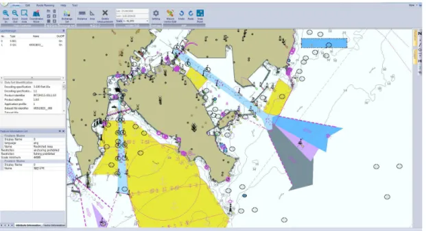
그림 9는 국립해양조사원에서 개발한 S- 100 뷰어를 이용하여 전자해도 자료에 항로정 보 인코딩 자료를 표시한 것으로, 전자해도 상 에 항로의 종류에 따라 색상을 구분하였으며, 항로를 클릭하면 각각의 항로별 정보사항을 정 보 창에서 확인할 수 있다.
5. 전문 사용자 검토
항로정보 데이터 모델의 설계 내용 및 인코 딩 테스트 성과에 대하여 부산항 등 국내‧외 항 로를 운항 경력이 20년 이상의 항해사 3명과 직접 인터뷰 방식으로 전문가 검토를 진행하였 다. 아래 표 8은 인터뷰 결과를 정리한 것이다.
항로정보를 전문적으로 사용하는 측면에서 항 로정보는 새로운 항만에 입항해야 할 경우 매 우 중요한 자료이며, 항로 고시내용을 확인하기 위하여 선사에 자료를 요청하는 경우도 있어서 현재의 항로정보를 쉽게 사용하지 못한다는 의 견이 있었다. 그리고 항로정보의 통합 서비스
<member>
<S-MRG:RouteingMeasure gml:id="f1">
<featureName>
<displayName>false</displayName>
<language>kor</language>
<name>부산항 항로 제1항로 부산항로</name>
</featureName>
<sourceIndication>
<categoryOfAuthority>maritime</categoryOfAuthority>
<countryName>KR</countryName>
<featureName>
<displayName>false</displayName>
<language>kor</language>
<name>부산항 항법 등에 관한 규칙</name>
</featureName>
<reportedDate>
<date>2018-09-10</date>
</reportedDate>
<source>부산지방해양수산청 고시 제2018-269호</source>
<sourceType>law or regulation</sourceType>
</sourceIndication>
<categoryOfRouteingMeasure>two-way route</categoryOfRouteingMeasure>
<categoryOfTrafficSeparationScheme>not IMO - adopted</categoryOfTrafficSeparationScheme>
<geometry>
<S100:surfaceProperty>
<S100:Surface gml:id="f15.S">
<gml:patches>
<gml:PolygonPatch>
<gml:exterior>
<gml:LinearRing>
<gml:posList>129.0610556 35.10588889 129.1099722 35.07738889 129.1141111 35.07005556 129.1193889 35.07836111 129.1130278 35.07938889 129.0633056 35.10838889</gml:posList>
</gml:LinearRing>
</gml:exterior>
</gml:PolygonPatch>
</gml:patches>
</S100:Surface>
</S100:surfaceProperty>
</geometry>
</S-MRG:RouteingMeasure>
</member>
TABLE 7. GML encoding data of 1st Fairway in Busan Port
FIGURE 9. Displayed S-MRG data on the S-101
Survey items Survey results
Q1. Do you use the ship routing information frequently when planning your voyage?
- ship routing information is very important if you have to go to a new port.
Q2. Do you think the ship routing information is sufficient?
- refer to the ship routing, but often see experience knowledge or cases.
* Port Entry is simplified, but it contains practical information such as water supply and refueling for each port required by the actual sailor Q3. How much do you use for navigation when there is
a local authority notice regarding shipping navigation and regulations?
- If you need a notice, you can check it separately from shipping company.
Q4. Would it be helpful if the ship routing information was provided in addition to the electronic chart?
- If ship routing information is provided separately, it will help to identify the routing.
* The ship route information is simple enough to be of practical use to the mate. The level of MRGs produced in Britain is also complex.
Q5. Do you think there is enough information to be included in the ship routing data model designed in this study?
- The prepared data model information appears to be sufficient.
Considering that it may seem complicated to the mate, consider sorting by area of interest.
* ex: port authorities, patrols, wire, fishing, etc Q6. Please suggest any additional information required
in the ship routing data model.
- I hope that the contents of the risk information(ex:dangerous depth) are added.
Q7. Do you think that the readability of ship routing information is appropriate when it is expressed by superimposing it on an electronic chart?
- Assessment that ship routing information is easy to understand * Explain that future technology development such as data interoperability
can be further improved Q8. Please suggest any improvement in the expression
of the ship routing information.
- The navigator should be able to quickly grasp the ship routing information and consider that it may be inconvenient if there is a lot of unnecessary information.
TABLE 8. Review report for professional users
환경이 구축된다면 항로 파악에 도움이 될 것 이라고 기대하였다. 본 연구의 내용 중에서 항 해사를 위한 항로정보는 최소로 하여야 하고 항만당국, 순찰용, 유선용, 어선용 등 관심분야 별로 구분하여 접근할 필요가 있다는 의견이 제시되었다. 이 밖에도 국제 기준과는 다르지만 위험요소가 될 수 있는 수심을 추가될 필요가 있다는 의견도 제시되었다.
결 론
우리나라에는 「해사안전법」에 따라 34개의 항로가 지정되어 있으며, 최근 항로 주변의 해 양사고가 증가하고 있다. 이러한 국내 실정을 반영하여 항로에 대한 안전한 환경을 만들어야 하고, SOLAS 협약에 규정되어 있는 항로정보 의 효과적인 제공이 필요하다. 그러나 해도와 항로지를 이용하여 항로정보를 제공하는 방법 으로는 신속한 항로정보 파악이 불가능한 실정 이다.
본 연구에서는 IHO에서 개발한 S-100 표준 을 기반으로 항로정보 데이터 모델의 설계를 수행하였다. 이를 위해 첫 번째, S-100표준 및 관련 제품 표준을 조사하였고, 우리나라의 항로 현황과 항로정보 제공방법의 문제점을 도출하 였다. 항로정보는 항로의 구분, 통항분리 여부, 항로의 위치, 각 항로별 항법, 속력 제한, 통항 제한 등 각기 다른 특성을 가지고 있어서 매우 복잡하고 특징을 가진다는 것을 알 수 있었다.
두 번째, 항로정보 제공 방법의 문제점을 조 사하였다. 현재 도면 형식의 해도와 책자 형식 의 항로지만으로는 항로정보를 쉽게 파악하는 것이 불가능하다는 것을 알 수 있었다.
세 번째, S-100 기반의 항로정보 데이터 모 델 설계를 하였다. S-100 기반의 데이터 모델 개발 단계는 일반적으로 6단계로 이루어지는데, 본 연구에서는 앞부분 세 개 단계인 요구 분석, 데이터 모델링, 인코딩 테스트에 대한 부분까지 를 연구하였다. 요구 분석 단계에서는 항로에 대한 IHO 표준을 분석하여 항목을 선정하였으 며, 데이터 모델링 단계와 인코딩 테스트는
S-100 표준의 절차에 따라 진행하였고, 인코 딩 테스트에는 S-100 뷰어 프로그램을 이용하 였다.
네 번째, 연구 결과에 대하여 국내외 항해 경 력이 많은 전문 사용자들을 대상으로 인터뷰 방식으로 전문 사용자 검토를 진행하였다. 인터 뷰를 통해 항로정보는 운항에 매우 중요한 자 료이며 이 연구를 시작으로 항로정보 표준이 마련되고 통합 서비스 방안이 강구된다면 항로 이용에 매우 중요한 자료가 될 것이라는 의견 을 얻었다.
본 연구는 항로정보에 대하여 IHO에서 구분 하고 있는 정보 중에서 중요 정보에 대해서만 항목 선정에 고려하였으며, 데이터 모델 개발의 6단계 중에서 앞부분 3개 단계에 한정하여 연 구하였기 때문에 기초단계의 연구 결과라고 할 수 있다. 향후 항로정보 데이터 모델에 관한 후 속연구가 진행된다면 항로정보 통합 서비스의 기반이 조성될 수 있을 것으로 판단된다.
주
1. 전국 무역항 입‧출항 선박 : 2016년 기준 407,655척(해양수산부, 2017 해양수산 통 계연보:363)
2. 개항 및 진입수로 해양사고 : 2012년 171 건, 2013년 126건, 2014년 145건, 2015 년 308건, 2016년 335건(중앙해양안전심 판원, 2016 해양사고 통계와 사고사례:14)
REFERENCES
HSK(Hydrographic Society of Korea). 2017.
An Introduction to Hydrogrphy : 410- 419 (한국수로학회. 2017. 수로학개론 : 410-419)
KHOA(Korea Hydrographic and Oceanographic Agency). 2016a. A Pilot Project to Establish the Safety Highway for Korean Routes. Result Report Chapter 1:1-6 (국
립해양조사원. 2016. 한국형 항로 안전하이 웨이 조성 시범사업 보고서. 제1장:1-6) KHOA(Korea Hydrographic and Oceanographic
Agency). 2016b. A Pilot Project to Establish the Safety Highway for Korean Routes. Result Report Chapter 4:1-77 (국립해양조사원. 2016. 한국형 항로 안전하 이웨이 조성 시범사업 보고서. 제4장:1-77) KHOA(Korea Hydrographic and Oceanographic
Agency). 2017a. South Coast of Korea Pilot (2017 Ed.):1-727 (국립해양조사원.
2017. 남해안항로지:1-727)
KHOA(Korea Hydrographic and Oceanographic Agency). 2017b. Ships’Routeing (IMO, 2015 Edition):1-30 (국립해양조사원. 2017.
항로지정:1-30)
Kim, H.S., C.H. Mun and, S.J. Lee. 2017. A Design of Data Model for Marine casualty based on S-100. Journal of Digital Contents Society 18(4):769-775 (김효승, 문창호, 이서정. 2017. S-100 표준 기반 해양 사고 데이터 모델 설계. 한국디지 털콘텐츠학회 논문지 18(4):769-775) KMST(Korean Maritime Safety Tribunal).
2017. 2016 Maritime Accident Statistics
and Accident Cases:14 (중앙해양안전심판 원. 2017. 2016 해양사고 통계와 사고사례:
14)
KR(Korean Register). 2012. SOLAS:787- 885 (한국선급. 2012. SOLAS:787-885) MOF(Ministry of Oceans and Fisheries).
2015. A Study of the Safety Evaluation for Ships Routes (Coastal Routes) Chapter 1:1-326 (해양수산부. 2015.
2015년 선박통항로 안전성평가 연구(연안통 항로) 제1편:1-326)
MOF(Ministry of Oceans and Fisheries).
2017. 2017 Statistical Yearbook of Oceans and Fisheris:363 (해양수산부.
2017. 2017 해양수산 통계연보:363)
Moon, J.S. and B.S. Kim. 2017. A Study on Issues and Reform Measures of Ship’s Routeing in the Maritime Safety Law.
Journal of Korean Association of Maritime Police Science Vol.7 No.3(15):
31-54 (문중식, 김병수. 2017. 「해사안전 법」상 항로지정방식의 문제점과 개선방안에 관한 연구. 한국해양경찰학회보 제7권 제3호 (통권 15호):31-54)