Journal of the Korean Society of Marine Environment & Safety Research Paper Vol. 24, No. 5, pp. 527-536, August 31, 2018, ISSN 1229-3431(Print) / ISSN 2287-3341(Online) https://doi.org/10.7837/kosomes.2018.24.5.527
1
1. 서 론국제해사기구(IMO, international maritime organization)는 해 양안전과 해양환경 보호를 목적으로 2019년 이내비게이션 도입을 추진하고 있다(An, 2015). 이내비게이션은 정보통신 기술(ICT, information & communication technology)을 활용하여 해상무선통신환경을 개선하고 선박에서는 전자해도, (ENCs,
를 기반으로 항법시스템을 자동화
electronic navigation chart) ·
표준화하며 육상에서는 관제와 모니터링을 통해 선박 안전운, 항을 원격지원하는 차세대 해양안전종합관리 체계이다(IMO
의 이내비게이션 전략 이행계획에 따라 세 MSC, 2008). IMO
First Author : [email protected], 02-6952-7251 Corresponding Author : [email protected]
계 각국에서는 ACCSEAS(Accessibility for shipping, efficiency advantages and sustainability), EfficienSea(Efficient, safe and sustainable traffic at sea), MONARISA(Motorways and electronic 등 이내비게이션 프로젝트와 navigation by intelligence at sea)
검증을 위한 테스트베드를 운영하며 국제 표준 선점 및 기, 술선도에 노력하고 있다(IALA, 2018).
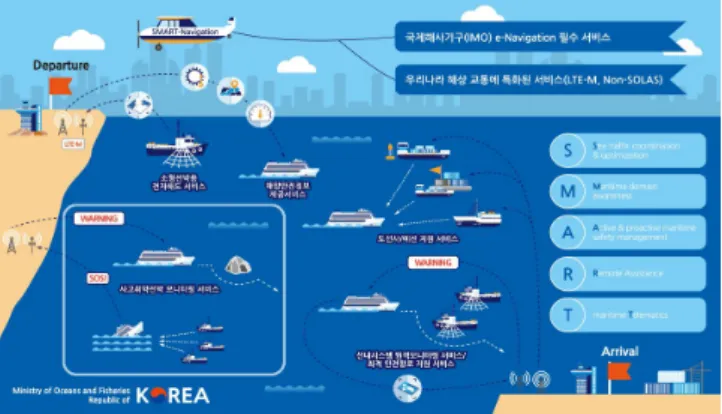
해양수산부도 이내비게이션 대응을 위해 Fig. 1과 같이 한 국형 이내비게이션인 SMART-Navigation 프로젝트를 운영하 고 있다(SMART-Navigation, 2018).
은 국제항행선박을 대상으로 하는
SMART-Navigation IMO
이내비게이션 개념을 어선과 연안 소형선 등 우리나라 해상 환경 특성에 맞도록 확대한 것으로, Table 1과 같이 IMO에서 지정한 이내비게이션 서비스(MSP, maritime service portfolio) 를 국내 해상환경에 맞추어 사고취약선박 모니터링 지원 ,
프로토타입 해사데이터 모델 개발
강남선 손금준 정유준 김혜진
마린웍스 주식회사 연구개발팀 한국선급
*, *** , **
Development of a Prototype S-100 Data Model
Namseon Kang* Gumjun Son** Yujun Jeong*** Hyejin Kim***
*, *** R&D center, Marineworks ltd., Busan 48792, Korea
** ICT center, Korean Register, Busan 46762, Korea
요 약 : 본 논문에서는 한국형 이내비게이션 프로젝트의 사고취약선박 모니터링 지원서비스 중 상황대응 및 상황관리 프로토타입 모 델을 개발하였다 프로토타입 모델 개발을 위해서 해사데이터 교환 표준 현황과 . S-100 표준 데이터 모델 개발 절차를 분석하고 개발 절차 에 따라 서비스의 요구사항 분석 및 관련 표준을 참고하여 상황대응 및 상황관리 모델에 대한 프로토타입 어플리케이션 스키마를 개발하 고, S-100 표준에 맞추어 프로토타입 피쳐 카탈로그와 프로토타입 포트레이얼 카탈로그를 제작하였다 개발된 프로토타입 데이터 모델의 . 검증을 위해서 광양항을 기반으로 테스트 데이터셋을 제작하고, S-100 기반 데이터의 유효성 검증을 위한 소프트웨어를 통해 검증한 결과 모든 데이터가 유효함을 확인하였으며, S-100 뷰어에서 정확한 위치에 지정된 심볼이 표출됨을 확인하였다.
핵심용어 : 공통 데이터 모델 프로토타입 해사데이터 모델, , S-100 표준 한국형 이내비게이션 프로젝트 상황대응 및 상황관리, ,
Abstract : In this paper, we developed a prototype model accident management SMART-Navigation project. In order to develop a prototype model, we analyzed the status of maritime data exchange standard and procedure. We developed accident management prototype application schema, feature catalog and portrayal catalog in accordance with S-100 standard data model development procedure by collecting requirements related services and referring to related standards. In order to verify accident management prototype model, we test data set based on Gwang-yang Port. The prototype model and test data verified verification software, and it was confirmed that the designated symbol was displayed at the correct position through the S-100 simple viewer.
Key Words : Common maritime data structure, Prototype S-100 data model, S-100 standard, SMART-Navigation project, Accident management
서비스 소형 선박용 전자해도 서비스 도선사 예선 지원 서, , / 비스 해안 선내 시스템 원격모니터링 서비스 최적 안전항, , 로 지원 서비스 안전정보 제공 서비스를 제공한다, (An, 2015;
SMART-Navigation, 2018).
가 이내비게이션 환경에서 해상과 육상 간의 일관된 IMO
데이터 교환과 활용을 위한 공통 데이터모델(CMDS, common 로 국제 수로기구
maritime data structure) (IHO, international
의 구조를 채택함에 따라
hydrograpic organization) S-100 SMART 서비스 제공을 위해서는 해사데이터 교환 표준인 -Navigation
구조에 따라 선육간 데이터를 교환해야 한다
S-100 (IMO MSC,
2008; Oh et al., 2012). 하지만 S-100 표준은 개발 진행중인 상 태로 2020년 개발 완료 예정인 SMART-Navigation 프로젝트에
적용이 어려우며 특히 , Table 1과 같이 우리나라 상황에 특 화된 서비스에 대한 국제 표준 개발은 예정되어있지 않기 때문에 SMART-Navigation 서비스에 적합한 해사데이터 교환 표준 개발이 필요하다.
본 논문에서는 SMART-Navigation 프로젝트의 프로토타입 테스트베드 검증이 가능하도록 각 서비스에 대한 프로토타 입 해사데이터 모델을 개발하였으며 구성은 다음과 같다. 2 장에서는 해사데이터 교환 표준 현황을 분석하고, 3장에서 는 한국형 이내비게이션 서비스 중 사고취약선박 모니터링 지원 서비스의 프로토타입 모델을 제시하고, 4장에서는 결 론을 제시한다.
해사데이터 교환 표준 2.
해사데이터 교환 표준 개발 현황 2.1
표준은 국제 표준인
IHO S-100 GI(Geospatial information)
의 시리즈 표준을 기반으로 하여 국제 해양지리정
ISO 19100
보 및 관련 데이터를 체계적으로 기술한 수로분야 공간지,
리 데이터를 위한 공통 데이터 모델에 관한 표준이다(Park, 2011; Park and Oh, 2014).
표준은 기존 수로데이터 표준인 이 가진 수로분
S-100 S-57
야에 제한된 범위 이미지 형태의 데이터 처리방법 등의 한, 계점을 개선하여 3D 데이터와 실시간 데이터 처리 및 웹서 비스가 용이하고 수로분야 뿐 아니라 육 해상 분야 데이터, 를 통합할 수 있는 Plug & Plug 방식의 목적지향관계형데이 터베이스(ORDBMS)로 설계되었다(Ward and Greenslande, 2011).
표준은 와 같이 기존 표준과 다른
S-100 Table 2 S-57 ISO
시리즈의 구조와 용어를 사용하며 특정 분야의 데이
TC/211 ,
터 구성 요소와 데이터 구조를 정하는 기준 모델 데이터 셋, 의 제작 및 배포 기준 등 데이터 규격 정의를 위한 데이터 모델과 절차를 포함한다 또한 . GI 표준에서 가장 중요한 분 야별 용어 데이터 구성 요소 데이터 규격 등의 저장 관리, , , 를 담당하는 저장소(registry)의 구성 및 등록 관리 절차에 관, MSP
No. Identified service SMART-
Navigation MSP 1 VTS information service (IS)
SV1/SV2/
SV3 MSP 2 Navigational assistance service (NAS)
MSP 3 Traffic organization service (TOS) MSP 4 Local port service
MSP 5 Maritime safety information service (MSI) SV5-2 MSP 6 Pilotage service
SV5-1 MSP 7 Tug service
MSP 8 Vessel shore reporting
MSP 9 Telemedical assistance service (TMAS)
MSP10 Maritime assistance service (MAS) SV1/SV2 MSP11 Nautical chart service SV4 MSP12 Nautical publication service SV4/SV5-2 MSP13 Ice navigation service
MSP14 Meteorological information service
SV5-2 MSP15 Real-time hydrographic and environmental
information service
MSP16 Search and rescue service SV1/SV2 Table 1. Comparison of IMO maritime service portfolio and
SMART-Navigation service (An, 2015)
Fig. 1. Project concept (SMART-Navigation, 2018).
S-100 S-57
registry/register no terms used
feature object
feature attribute attribute enumerated values attribute values feature concept dictionary object catalogue
curve edge
point node
surface face
application schema application profile Table 2. Difference between S-100 and S-57 (Ward, 2010)
한 규정을 포함한다(Park, 2011; Park and Oh, 2014; Ward and Greenslande, 2011; Ward, 2010).
표준은 의
S-100 IMO CDMS, IHO UHDM(Universal hydrographic
국제항로표지협회 의
data model), (IALA) IHDM(IALA harmonization
을 근거로 와 같이 기타 기관의
data model) Fig. 2 IHO, IALA, 도메인으로 구분된다(Yu, 2013).
Fig. 2. IHO Registry based on IHO standard S-100 and S-99 and underpinned by ISO 191xx series (Yu, 2013).
는 과 같이 전자해도
IHO Table 3 (ENC, electronic navigation 해사 간행물 등과 같은 해양지리정보 분야의 제품표 chart),
준을 개발하고 있으며, IALA는 e-Navigation technical services
에 데이터 프레임워크 채택을 명
documentation guideline S-100
시하고 해상교통과 관련된 VTS, AIS AtoN 등에 대한 S-20x 표준을 개발하고 있다 기타 도메인으로는 세계기상기구.
가 빙하정보와 해상기상정보에 관한 표준
(WMO/Inland) S-40x
을 개발하고 있다.
표준 데이터 모델 개발 절차 2.2 S-100
제품 표준은 과 같이 공간정보 저장소
S-100 Fig. 3 (Geospatial
일반 피처 모델
information registry), (GFM, general feature model), 제품 명세(Product specification)로 구분된다 공간정보 저장소. 는 피쳐(Feature)에 대한 이름과 정의를 표준화 데이터로서 관리하기 위한 FCD(Feature concept dicitionary), 화면 표시에 관련된 항목을 관리하는 Portrayal, Metadata 등의 독립적인 저 장소들이 존재한다(Park et al., 2012).
은 위치적 특성을 가진 정보단위인 피처에 기반한 데 GFM
이터의 개념 및 개념의 관계 요소를 정의하기 위한 메타 데 이터 모델이다(Park, 2011; Park et al., 2012).
제품 명세는 GFM과 같은 메타 데이터 모델을 바탕으로 특정 해양 데이터를 표현하는 기준을 정한 규격으로 피쳐카 탈로그 포트레이얼 카탈로그 메타데이터 데이터 셋의 구, , , 조 인코딩 포맷 등을 포함한다, (Park et al., 2012).
Fig. 3. Standard configuration of S-100 product (Park, 2011).
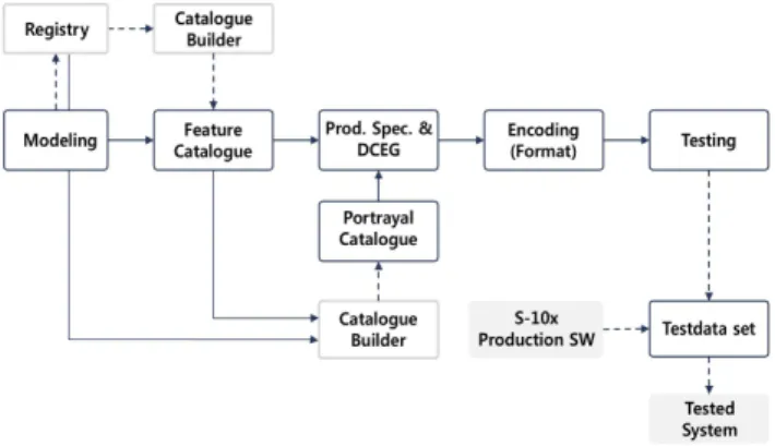
특정 S-100 제품 표준을 개발하기 위해서는 Fig. 4와 같이
사용자의 요구사항을 분석하여 분석된 정보가 GI 레지스트
리의 FCD에 등록된 경우 등록된 표준 데이터를 사용한다. MSP
No. Identified service SMART-
Navigation S-101 Electronic navigational chart(ENC) draft S-102 Bythmetric surface V1.0 S-10x Tidal product for surface navigation ongoing S-103 Sub-surface navigation ongoing
S-111 Surface currents draft
S-112
Meteorological and hydrographic data AIS application-specific message dynamic water level data product specification
draft S-121 Maritime limits and boundaries draft S-122 Marine protected areas draft
S-123 Radio services ongoing
S-124 Navigational warnings ongoing S-125 Navigational services planned S-126 Physical environment planned S-127 Traffic management planned
S-1xx Marine services planned
S-1xx Digital mariner routing guide planned S-1xx Harbour infrastructure planned S-1xx S-1xx (social/political) planned S-201 Aids to navigation information draft S-210 Inter VTS exchange format ongoing S-230 Application specific messages ongoing S-240 DGNSS station almanac draft
S-245 eLoran ASF data ongoing
S-246 eLoran station almanac ongoing
S-401 Inland ENC draft
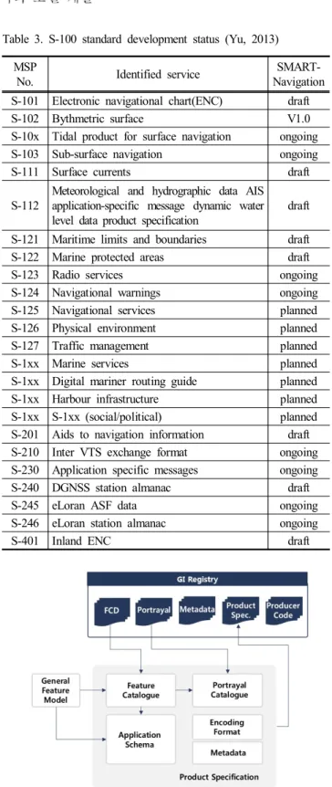
Table 3. S-100 standard development status (Yu, 2013)
Fig. 4. S-100 product development concept (Oh et al., 2012).
등록되어 있지 않은 경우 레지스트리에 등록한 후 GFM에 따라 Fig. 5와 같이 어플리케이션 스키마 피쳐 카탈로그 개, 발 포트레이얼 카탈로그 개발 데이터 명세서, , (DCEG, data
작성 테스트 데이터셋
classification encoding guide) , (TDS, test 제작 및 이를 이용한 검증으로 이루어진다
dataset) .
Fig. 5. S-100 product development procedure (Park, 2011).
Fig. 6. Application schema according to S-100 standard.
어플리케이션 스키마 2.2.1
어플리케이션 스키마는 모델링 대상 정보를 Fig. 6과 같이 위치적 특성을 가진 정보의 단위인 피쳐와 위치적 특성을 가지지 않는 정보의 단위인 인포메이션으로 구분하고 이에 대한 속성(attribute)과 정보들간의 관계(association)를 UML
로 표현한 것으로 피쳐 카탈로그 (unified modeling language) , , 포트레이얼 카탈로그와 데이터셋 개발을 위한 기준이 되는 문서이다.
피쳐 카탈로그 2.2.2
피쳐 카탈로그는 S-100 표준의 Feature Catalogue Schema를
기준으로 작성하며 데이터를 어플리케이션 스키마에서 정,
의된 모든 피쳐 및 인포메이션과 이에 대한 모든 이름 타입 목록 이름 타입에 관한 프로퍼티 목록 이름 타입과 프로퍼, , 티 목록간의 연결 방법에 관한 정보를 작성한다 피쳐 카탈.
로그는 XML 파일과 작업자가 해독 가능한 문서 형식으로
작성한다.
포트레이얼 카탈로그 2.2.3
포트레이얼 카탈로그는 어플리케이션 스키마에서 정의된 피쳐 및 인포메이션 중에서 화면에 표시가 필요한 정보에
대한 내용을 다룬다 포트레이얼 카탈로그는 화면에 표시하.
기 위한 모든 사항들의 정보가 작성된 XML 문서와 portrayal management concepts, portrayal parameters, colour definitions, 등 피쳐를 지도에 묘사하기 위한 파일로 구 symbol definition
성된다.
카탈로그 2.2.4
데이터 셋은 피쳐 카탈로그에 정의된 데이터를 어플리케이 션 스키마에서 정의한 구조에 따라 실제 전달되는 데이터이 다 데이터셋은 . S-100표준에 정의된 Table 4의 인코딩 방법을 사용할 수 있으며, GML이 가장 보편적으로 사용되고 있다.
Encoding
standard Contents
ISO 8211 S-57 Electronic chart data encoding standard GML Geographic information markup language XML Scalable markup language
GeoTIFF Geographic reference information TIFF extension standard for easy
HDF-5 Hierarchical data format version 5 JPEG2000 JPEG (joint photographic experts group) -
Common methods used for photo data compression Table 4. Dataset encoding method define in the S-100 standard
프로토타입 모델 개발 3.
한국형 이내비게이션 프로젝트에서는 Table 5와 같이 가6 지 서비스를 제공한다 본 연구에서는 . Table 5의 가지 서비6 스 중 선박과 육상간 데이터 교환에 , S-100 표준을 적용하는 서비스를 프로토타입 해사데이터 모델 개발 대상으로 하며,
의 서비스의 데이터 목록 상위설계서를 분석하여
Table 5 ,
과 같이 사고취약 선박 모니터링 서비스 선내시스템 원
Table 6 ,
격 모니터링 서비스 최적항로 서비스 도선사 및 예선지, , 원서 비스 가지 서비스에 대한 항해 위험도4 (Voyage risk), 취약성평가
상황대응 및 상황관
(Vulnerability), 리(Accident management), 선 박 알람(Ship alarm), 위기상황 가이드라인(Emergency guidance), 최적항로(Optimal route), 도선사 및 예선지원서비스(Pilot service) 7개의 프로토타입 모델을 선정하였다.
본 연구에서는 Table 6의 개 프로토타입 모델 중 상황대7 응 및 상황관리 모델에 대하여 논한다.
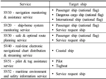
Service Target ship
SV10 - navigation monitoring
& assistance service
Passenger ship (national flag)
Dangerous cargo ship (national flag)
International ship (national flag) SV20 ship-borne system
monitoring service
Passenger ship (national flag)
Service request ship SV30 - safe & optimal route
planning service
Passenger ship (national flag)
Service request ship SV40 - real-time electronic
navigational chart distribution
& streaming service
Coastal ship SV51 - pilot & tug assistance
service
Pilot
Tugboat SV52 - maritime environment
and safety information service Service request ship
Table 5. SMART-Navigation service (SMART-Navigation, 2018)
어플리케이션 스키마 개발 3.1
상황대응 및 상황관리 모델은 선박의 주요 제원과 위치,
운항정보 항행계획 뿐 아니라 사고이력 해상교통 정보 등 , , 빅데이터 정보를 연계하고 사고 취약상황을 평가하고 지원 하는 사고취약 선박 모니터링 서비스의 가지 모델 중 하나3 로 해양사고가 발생한 그 시점에서의 해양사고 대응에 필요 한 정보를 생성하여 신속한 대응을 지원하는 해양사고대응 지원 서브시스템을 위한 모델이다.
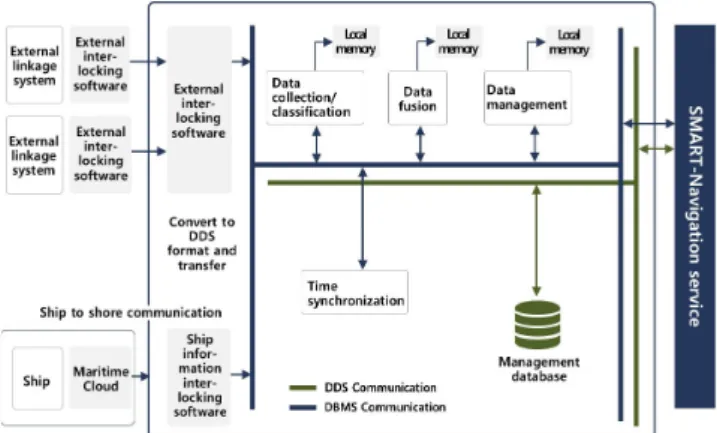
한국형 이내비게이션 프로젝트에서는 데이터 수집 활용/ / 관리를 위해서 Fig. 7과 같이 데이터 수집 분류 데이터 관리/ , ,
데이터베이스 어뎁터의 가지 서브시스템으로 구성된 대용3
량 데이터관리 시스템(DSP, data service platform)을 운영한다.
는 과 같이 통신 미들웨어를 통해 외부연동처
DSP Fig. 8 DDS
리 소프트웨어 선박연동 소프트웨어 및 서비스 소프트웨어,
의 데이터를 수집하고 송수신 데이터는 DDS의 Topic으로 관 리된다(SMART-Navigation, 2017).
따라서 상황대응 및 상황관리 프로토타입 모델 개발을 위하여 해양사고대응지원 서브시스템의 DDS Topic을 분석
하고 해사데이터 교환 표준은 선박과 육상간 데이터 교환,
에 적용되므로 해양사고대응지원 서브시스템의 DDS Topic 중 Fig. 7의 선박정보연동 소프트웨어에 해당되는 DDS Topic 을 Table 7과 같이 분류하였다.
Ser-
vice Model
name Contents
SV10 Voyage risk
[Risk of collision] To recognize the risk of collision and to minimize the risk by calculating and indexing the risk of collision between all combinations with neighboring ships based on charity in real time.
[Standing risk] Identify the risk of standing on the route of vessels in the control breakdown in real time.
Vulnerability
A variety of maritime environments and ship information are analyzed to identify the vulnerabilities of ships under sailing and to identify the marine accident in advance.
Accident management
After the initial information about the marine accident is recognized automatically or manually, it is possible to estimate the accident situation according to the type of accident based on all the initial situation information and initial information related to the marine accident occurred, ships, etc.
SV20
Ship alarm Sensor data is collected and managed by data of each ship's.
Emergency guidance
Based on the sensor information of the ship, it determines the risk of the ship and provides the emergency guidance for the ship.
SV30 Optimal route
Provide optimal safety routes using maritime safety information such as real-time vessel traffic, maritime environment, and weather information only for vulnerable vessels or service request vessels such as coastal passenger ships on land.
SV51 Pilot service
Safety information such as weather information and dynamic motion
characteristics of the traffic information line is provided to the pilot in the lead area.
When approaching the pier, information such as the distance to the pier, the speed of lateral movement, and the predicted travel position of the vessel are provided so that the pilot can safely berthing.
Table 6. Prototype model list
Fig. 7. Data service platform configuration (SMART-Navigation, 2017).
Fig. 8. Mass data management software diagram (SMART- Navigation, 2017).
Massage name Data identification
response support system for maritime distress
AccidentVesselResult
DATATIME ACCIDENTTIME lattitude
longitude
ACCIDENT_TYPE
PredictionResult
Time Longitude lattitude Heading Table 7. DDS Topic of accident management system
의 과 상위설계서를 분석하고 서비스의
Table 7 DDS Topic ,
모델링 요구사항을 반영하여 Table 8과 같이 S-100 표준에 맞추어 어플리케이션 스키마 개발을 위한 데이터를 정의하 였다.
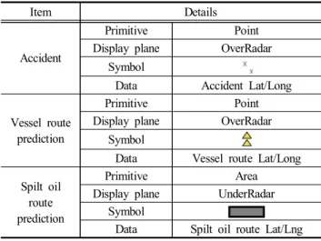
상황대응 및 상황관리 프로토타입 모델은 실제 지형지물 을 표현하며 위치정보를 가지는 , Feature type이며, Accident, Route prediction, Vessel Route prediction, Spilt oil route prediction
개의 피쳐로 구성된다 피쳐는 사고가 발생한 선박
4 . Accident
의 위치정보 등 선박사고 상황파악에 필요한 정보를 관리하 며, Route prediction 피쳐는 선박 사고 후 선박의 예상 이동경 로와 유출유의 예상 이동경로에 대한 공통적인 부분에 대한 정보를 관리한다. Vessel Route prediction 피쳐는 사고 선박의 예상 이동경로 위치정보를 관리하고, Spilt oil route prediction
Type Class name
Class
description Display Attribute name Attribute
description Type Multiplicity Range
Feature
Accident It describes the marine accident
Issue Date data creation date dateTime 1..1 Accident Date accident date dateTime 1..1
MMSI MMSI text 1..1
× Accident Lat location of accident
real 1..1
× Accident Long real 1..1
Accident Type accident type enumeration 1..1
1:Unknow 2:Collision 3:Grounding 4:Fire 5:Flooding Route
prediction
predict time of the
accident Predict Time predict time dateTime 1..1 Vessel
route prediction
It predicts the development of the accident
× Vessel Route Lat vessel Route lat real 0..1
× Vessel Route Long vessel Route long real 0..1 Vessel Route Hdg vessel Route Hdg real 0..1 Split oil
route prediction
It predicts the development of the accident
Split Oil Route Used spiltOilRouteUsed integer 0..1 0~200
× Split Oil Route Lat spiltOilRouteLat real 0..1
× Split Oil Route Long spiltOilRouteLon real 0..1 Table 8. Accident management prototype model data details.
피쳐는 유출유의 예상 이동 분포정보를 관리한다. Table 8의
개 에 대해 표준 문법에 따라 데이터 타입과 다
4 Feature S-100
중도를 결정하고 구조를 잡아 Fig. 9와 같이 상황대응 및 상 황관리 프로토타입 어플리케이션 스키마(Application schema) 를 개발하였다.
Fig. 9. Accident management prototype model.
Fig. 10. Accident management model – feature catalog.
피쳐 카탈로그 제작 3.2
Accident, Route Prediction, Vessel Route Prediction, Spill Oil
등 의 프로토타입 어플리케이
Route Prediction Table 8, Fig. 9
션 스키마에 제시된 피쳐에 대한 데이터 타입 데이터 사이, 즈 다중도 데이터 범위 우선순위 등을 , , , S-100 표준 Edition 3 에 따라 Fig. 10과 같이 XML 기반의 상황대응 및 상황관리 프로토타입 피쳐 카탈로그를 XML Spy 2017을 사용하여 제 작하였다.
포트레이얼 카탈로그 제작 3.3
포트레이얼 카탈로그는 Fig. 11과 같이 XML 문서와 colour
등 피쳐를 지도에 묘사하기 위한 definitions, symbol definition
파일로 구성된다.
상황대응 및 상황관리 프로토타입 모델의 포트레이얼 카
탈로그 개발을 위하여 서비스에 표출 여부를 확인하였으며,
표출이 필요한 Accident, Vessel route prediction, Spill oil route
피쳐의 표출방법을 와 같이 정의하였다
prediction Table 9 .
Fig. 11. Portrayal catalog configuration.
Item Details
Accident
Primitive Point
Display plane OverRadar Symbol
Data Accident Lat/Long
Vessel route prediction
Primitive Point
Display plane OverRadar Symbol
Data Vessel route Lat/Long Spilt oil
route prediction
Primitive Area
Display plane UnderRadar Symbol
Data Spilt oil route Lat/Lng Table 9. Accident management model – symbol
Fig. 12. Accident management prototype model – portrayal catalog.
와 은 선박단위로 시점에 따 Accident Vessel route prediction
라 하나의 위치를 가지기 때문에 Point , Spilt oil route 로 은 표현하고자 하는 대상의 특성상 면적으로 제시 prediction
되어야 하므로 area로 타입을 제시하고 서비스의 검토를 수, 행하였다 검토가 완료된 . Table 9의 심볼을 심볼에디터를 사 용하여 제작하고, Rule, Display Plane 및 Viewing group 등을 정의하여 Fig. 12와 같이
X
ML 기반의 프로토타입 포트레이 얼 카탈로그를 XML Spy 2017을 사용하여 제작하였다.테스트 데이터셋 제작 3.4
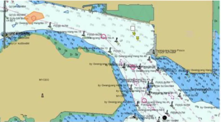
개발된 상황대응 및 상황관리 프로토타입 모델의 검증을 위하여 광양항을 대상으로 선박 사고와 사고선박의 예상경 로에 대한 테스트 시나리오를 Table 10과 같이 작성하고, Fig.
과 같이 기반의 데스트 데이터셋을 작성하였다
13 GML .
또한 Table 10의 테스트시나리오를 Fig. 14와 같이 전자해 도표시장치(ECDIS, electronic chart display and information
에 표시하여 상황관리 프로토타입 모델의 검증을 위 system)
한 참고자료로 제시하였다.
Fig. 13. Accident management prototype model – test dataset.
Accident 1 Accident 2
issueDate 20170912T050000 issueDate 20170912T120000 accidentDate 20170911T020000 accidentDate 20170912T050000
MMSI 111222333 MMSI 222333444 accidentType Unknown accidentType Grounding
Coordinate 34.900683
127.754100 Coordinate 34.903017 127.694950 Vessel Route Predict 1 Vessel Route Predict 2 predictTime 20170912T120000 predictTime 20170912T120000 vesselRouteHdg 180 vesselRouteHdg 180
Coordinate 34.898967
127.755150 Coordinate 34.897167 127.755617 Table 10. Accident management prototype model test scenario
Fig. 14. Reference picture for test scenario.
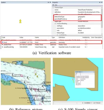
프로토타입 모델 검증 3.5
개발된 상황대응 및 상황관리 프로토타입 모델의 유효성 을 확인하기 위해서 한국선급에서 개발된 S-100 simple viewer
와 마린웍스에서 개발된 검증 소프트웨어를 활용하였다.
Fig. 15. S-100 simple viewer.
는 와 같이 기반 제품 표준
S-100 simple viewer Fig. 15 S-100
을 묘화할 수 있는 지원도구이며 검증 소프트웨어는 , Fig. 16 와 같이 해사데이터 표준 데이터를 화면에 표시하고 표준 , 정보에 일치되지 않은 데이터의 오류체크가 가능한 S-100
기반 데이터의 유효성을 검증을 위한 지원도구이다.
Fig. 16. Verification software.
상황대응 및 상황관리 프로토타입 모델의 검증은 Table
의 와 피쳐의 속성값과 심볼
10 Accident Vessel route prediction
을 Fig. 16의 검증 소프트웨어를 통해 확인하였다 또한 . Fig.
의 에 정상적으로 표출되는지 확인하고
15 S-100 simple viewer ,
표출된 화면을 Fig. 14의 참고 화면과 비교하였다.
각 피쳐의 위치 정보는 검증 소프트웨어에서 Geometry
에 따라 에서 표시 될 수 있는 정보인
type S-100 simple viewer
지를 확인하고 검증 소프트웨어와 , S-100 simple viewer의 세 부 정보창에서 값을 비교 확인하였다 각 피쳐의 화면 표시 . 여부는 검증 소프트웨어에서 해당 심볼을 확인하고, S-100
에서 와 같이 묘화되는지 여부와 피쳐의
simple viewer Fig. 14
세부 속성값을 비교 검증하였다.
(a) Verification software
(b) Reference picture (c) S-100 Simple viewer Fig. 17. Accident feature verification results.
의 피쳐 테스트 데이터를 검증 소프트웨
Table 10 Accident
어에서 확인한 결과 Fig. 17 (a)와 같이 issueDate, accidentDate,
이 정상적으로 확인되었으며 에서
MMSI, accientType , Table 9
지정된 primitives와 data, 심볼이 정상적으로 적용됨을 확인 하였다. Fig. 17 (b)와 비교하여 Fig. 17 (c)와 같이 S-100 simple
에서 정상적으로 피쳐가 표출되었으며 검증
viewer , Fig. 17 (a)
소프트웨어와 Fig. 17 (c)의 S-100 simple viewer에서 accident 피쳐 위치 속성값과 심볼이 동일함을 확인하였다.
의 피쳐 테스트 데이터를 검
Table 10 Vessel route prediction
증 소프트웨어에서 확인한 결과 Fig. 18 (a)와 같이 predictTime,
이 정상적으로 확인되었으며 에서 지
vesselRouteHdg , Table 9
정된 primitives와 data, 심볼이 정상적으로 적용됨을 확인하 였다. Fig. 18 (b)와 비교하여 Fig. 18 (c)와 같이 S-100 simple
에서 피쳐가 정상적으로 표출되었으며 검
viewer , Fig. 18 (a)
증 소프트웨어와 Fig. 18 (c)의 S-100 simple viewer에서 Vessel
피쳐 위치 속성값 의 데이터 값이 일
route prediction , Table 10
치하고, Table 9와 Fig. 18 (a) 검증 소프트웨어, Fig. 18 (c)의 의 심볼 등이 동일함을 확인하였다
S-100 simple viewer .
(a) Verification software
(b) Reference picture (c) S-100 Simple viewer Fig. 18. Vessel route prediction feature verification results.
결 론 4.
본 연구에서는 SMART-Navigation 프로젝트의 프로토타입 테스트베드 검증이 가능하도록 프로토타입 데이터 모델을 개발하였다.
프로젝트 서비스 중 상황대응 및 상황 SMART-Navigation
관리 프로토타입 모델 개발을 위해서 DDS Topic, 상위설계 서 요구사항 분석서 인터페이스 데이터를 분석하여 , , S-100 표준 문법에 따라 상황대응 및 상황관리 프로토타입 모델의 프로토타입 어플리케이션 스키마를 개발하고 피쳐 카탈로그 와 묘화를 위한 심볼과 포트레이얼 카탈로그를 제작하였다.
개발된 상황대응 및 상황관리 프로토타입 모델의 유효성 을 확인하기 위해서 테스트 데이터셋을 제작하여 해사데이 터 검증 소프트웨어와 S-100 Simple viewer을 통해 검증한 결 과 입력된 사고 정보와 심볼이 정상적으로 표출됨을 확인하 였다.
앞으로 수행될 연구에서는 프로토타입 모델 개발 결과를 바탕으로 SMART-Navigation standard model - contents model을 개발하고자 한다.
후 기
이 논문은 2017년 해양수산부 재원으로 한국해양과학기 술진흥원의 지원을 받아 수행된 연구임(IMO 차세대 해양안 전 종합관리 체계 기술 개발).
References
[1] An, K.(2015), A study on the improvement of maritime traffic management by introducing e-Navigation, Journal of the Korean Society of Marine Environment & Safety, Vol. 21, No. 2, pp. 164-170.
[2] IALA(2018), e-Navigation products & project, Available;
http://www.iala-aism.org/products-projects/e-navigation.
[3] IMO MSC(2008), Report of the maritime safety committee on its 58th session, Annex20 - Strategy for the development and implementation of e-Navigation, MSC 85/26/Add. 1.
[4] Oh, S. W., H. Y. Kim, S. H. Suh and S. Y. Kim(2012), Application of S-100 standard in the field of e-Navigation, Journal of Navigation and Port Research International Edition, Vol. 36, No. 2, pp. 105-112.
[5] Park, D. W and S. H. Oh(2014), “Information service of e-Navigation environment and S-100”, Autumn Annual Conference 2014, Korean Institute of Navigation and Port Research, pp. 230-232.
[6] Park, J. S., M. K. Moon and K. H. Yeon(2012), A feature concept dictionary registry for international hydrographic data based on S-100 standard, Korea Nest Generation Computing Society, pp. 49-59.
[7] Park, S. H.(2011), S-100 metadata conversion design of the OWL-based ontology, Journal of Korea Institute of Information and Communication Engineering, Vol. 15, No.
11, pp. 2334-2339.
[8] SMART-Navigation(2017), Annual report - SV10 results for 2017, pp. 3-20.
[9] SMART-Navigation project(2018), Available; http://www.smart- nav.org.
[10] Ward, R.(2010), IHO S-100 the universal hydrographic data model, The Norwegian Coastal Administration, Available;
http://www.kystverket.no/globalassets/e-navigation/iho-s-100.pdf.
[11] Ward, R. and B. Greenslande(2011), IHO S-100 The universal hydrographic data model, IHO, Available; https://www.iho.int/
mtg_docs/com_wg/TSMAD/TSMAD_Misc/S-100InfoPaper_
FinalJan2011.pdf.
[12] Yu, Y. H.(2013), Progress of IMO e-Navigation and trend of international standards - Focused on IALA e-Nav committee and IEC TO80, TTA Journal, Vol. 146, pp. 73-78.
Received : 2018. 07. 10.
Revised : 2018. 08. 22.
Accepted : 2018. 08. 28.