IEG 환경지질연구정보센터
13
0
0
전체 글
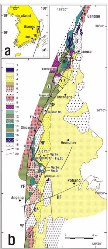
(2) 146. Pom-yong Choi. (Continued) to black mudstone, light gray sandstone and arkosic fine sandstone, and rarer conglomerate (Unit II). 16. Reddish mudstone and pebbly sandstone (Unit I, in the Ganggu-Jangsa area). 17. Jurassic (?) diorite. 18. Jurassic granite. 19. Fault. 20. Concealed or inferred fault. DF=Docheon Fault. DT=Daljeon Tunnel. GF=Gojusan Fault. HF =Hyongsan Fault (Lee et al., 1990). MF=Malgol Fault. M’F=Moa Fault. NF=Naengsu Fault. OF=Ogeum Fault. WF=Winmal Fault. YF=Yangsan Fault. Y’F=Yugye Fault. Fig. 1.. and lower limits of each formation within the group. Therefore, the various formation names are not used in this paper, but rather the sedimentary rocks are divided into several units using rock color and stratigraphic relationship (Fig. 1). The Cretaceous sedimentary rocks are divided as follows in an ascending order. (1) Unit I: reddish mudstone and pebbly sandstone (in the Ganggu-Jangsa area); (2) Unit II: dark gray to black mudstone, light gray sandstone and arkosic fine sandstone, and small amount of conglomerate (largely assigned to the Banyawol Formation; Chang et al., 1990); (3) Unit III: reddish mudstone, sandstone, and some conglomerate; (4) Unit IV: conglomerate, corresponding to the Chongryangsan Formation (Chang et al., 1990); (5) Unit V: dark gray mudstone; (6) Unit VI: tuffaceous sandstone, andesitic tuff and volcanic breccia.. Location (a) and geological maps (b) of the study area. 1. Quaternary deposit (excluding alluvium). 2-5. Miocene rocks. 2. Basalt. 3. Mudstone-dominant unit. 4. Conglomerate-dominant unit. 5. Granite wash. 6-7. Paleogene rocks. 6. Felsite or rhyolite. 7. Rhyolitic welded tuff. 8-11. Late Cretaceous to Paleogene rocks. 8. Granite. 9. Rhyolitic/andesitic tuff. 10. Andesite. 11-16. Cretaceous sedimentary rocks. 11. Tuffaceous sandstone, andesitic tuff and volcanic breccia (Unit VI). 12. Dark gray mudstone (Unit V). 13. Conglomerate (Unit IV; Chongryangsan Formation). 14. Reddish mudstone, sandstone, and conglomerate (Unit III). 15. Dark gray Fig. 1.. The Late Cretaceous - Paleogene andesite, rhyolitic/andesitic tuff, and (hornblende) granite, together with Paleogene rhyolitic welded tuff and rhyolite or felsite, intruded or covered the upper Cretaceous sediments (for the age dating results around Pohang, see Shibata et al., 1979 and Jin et al., 1989). The ‘felsite’ of older literatures variously corresponds to Late Cretaceous - Paleogene rhyolitic/andesitic tuff, Paleogene rhyolitic welded tuff and rhyolite/felsite. Here the so called ‘felsite’ is classified into three units as strictly as possible, because the three rock units play an important role in analyzing the displacements of faults. Andesite is distributed around Bogyeongsa temple and is displaced by the Yangsan Fault. Rhyolitic tuff is distributed widely in the study area, and in part, comprises the andesitic tuff. Hornblende granite crops out around Singwang and Moari, and is displaced by the Yangsan Fault and its branch faults. Conglomerate and pebbly sandstone, sandy mudstone, mudstone and marl were deposited in the Miocene Pohang Basin. The depositional systems along the western boundary of the basin are known as fan-delta systems such as ‘Doumsan, Malgol, Gohyun, Duksung and Yugye fan-delta systems (Chough et al., 1989; Hwang et al., 1995; see also Sohn et al., 2001; Sohn, 2004). The Miocene sediments have been divided into several.
(3) ‘Singwang strike-slip duplex’ around the Pohang Basin, SE Korea. 147. Outcrop photographs showing the various Miocene strata. (a) Foreset and topset of the Gilbert-type fan-delta (Doumsan Fan-delta System) along the road from Hakcheon-ri, Heunghae to Naengsu-ri, Singwang, that is, on the eastern side of Doeumsan Mountain (by the courtesy of Dr. I.G. Hwang, KIGAM). (b) Massive or crudely stratified gravelstone deposited near the basement at Naengsu-ri, west of the Doeumsan Mountain. (c) Outcrop of granite wash along the Gokgangcheon stream at Sajeong-ri, Singwang. (d) Loading structure composed of N-S and E-W trending normal faults in the mudstone dominant unit in a road-cut, east of the Doeumsan Mountain. Gravelstone and mudstone fill the depression in the mudstone dominant unit. (e) Mudstone dominant unit near the Daljeon Tunnel. (f) Calcareous mudstone (or marl) overlying gravelstone at Kkukkurim, Daljeon-ri. Locations of outcrops are denoted in Figure 1. Fig. 2.. formations (Um et al., 1964; Kim, 1970; Yoon, 1975; be rather affected by branch faults of the Yangsan Fault Yun, 1986; Choe and Chough, 1988). Because the distri- and related transfer faults, it is not easy to identify the bution of a formation ( ., the Chunbuk Formation) may formations in field and for the purpose of structural anale.g.
(4) 148. Pom-yong Choi. ysis, and so only three units are adopted in this paper; granite wash, conglomerate-dominant unit and mudstonedominant unit. In the study area, granite wash consists of the weathered granitic materials and exotic clasts. In other words, it corresponds to pebbly sandstone or gravelstone in which the matrix consists of quartzofeldspatic sand (Fig. 2c). Exotic clasts mainly comprise boulders originating from granitic masses and, less frequently, Cretaceous sedimentary rocks. Granite wash was deposited in the basal part of the Pohang Basin from place to place, and was underlain by or changed into the conglomerate-dominant unit. At Sajeong-ri (SJR; Fig. 4a), Singwang, granite wash outcrops well along the Gokgangcheon stream, and is in faulted contact (Gojusan Fault; Fig. 5c) with the rhyolitic tuff. The conglomerate-dominant unit consists largely of conglomerate (Fig. 2a, b), with some pebbly sandstone, sandy mudstone and calcareous mudstone (marl; Fig. 2f). Along a valley at Naengsu-ri, west of Doeumsan Mountain, massive gravelstone or crudely stratified gravelstone of subrounded to subangular pebbles deposited on the basement of rhyolitic and andesitic tuff can be observed (Fig. 2b). From Gojusan Mountain to Doeumsan Mountain, the boundary between the conglomerate- and mudstone-dominant units coincide roughly with the boundary between S4 (slope-apron conglomerate and hemi-pelagic mudstone) and S5 (submarine-fan conglomerate and hemipelagic/pelagic mudstone), or between SP IV (Gilbert-type foreset conglomerate) and SP V (hemipelagic mudstone with conglomerate/ sandstone lenses) suggested by Sohn (2004). In the other areas, the boundary rather depends on the grain size. Around the eastern entrance of the Daljeon tunnel (DT; Fig. 1b), mudrocks (sandy mudstone, siltstone and mudstone) are deposited just near the vertical discontinuity or fault escarpment located at the extension of the Malgol Fault and transfer faults (Fig. 2e). At the Kkukkurim valley, Daljeon-ri, reworked tuffaceous pebbly sandstone derived from the bedrock of Cretaceous rhyolitic tuff crops out, and then is underlain by, changes into, well-organized conglomerate. It should be noted that the distribution of the conglomerate-dominant unit is controlled by branch faults of the Yangsan Fault and related transfer faults in separate areas (Fig. 1). The Doumsan and Gojusan fan-delta systems (Sohn, 2004) are corresponding to two examples of those formed in the upper areas. Around Docheon-ri (DCR), northwest of Jangsa (Figs. 1 and 3), basalt intruded the Cretaceous sediments and Paleogene rhyolitic welded tuff. At Daljeon-ri, basalt also intruded Paleogene rhyoltic lapilli tuff and is underlain by the Miocene mudrocks (Figs. 1 and 4). The latter basalt was dated to be middle Miocene (Lee et al., 1992).. 3. GEOLOGICAL STRUCTURE 3.1. Ganggu-Yugye Area In the Ganggu-Jangsa area, the Jangsa Fault (Choi et al., 2004) is developed along the eastern boundary of the Pohang Basin (Fig. 3a), even though some authors have postulated it to the Yangsan Fault. According to older concepts, these two faults were treated as one fault, that is, the ‘Yangsan Fault’, but they are not the same one. In this study, the name ‘Yangsan Fault’ is retained for the former ‘Yangsan Fault’ in the Jangsa-Busan area. The Jurassic granites are also located from Ganggu to Jangsa, especially on the eastern side of the Jangsa Fault (Figs. 3a and 5a). At Yangseong-ri (YSR) and Hoe-ri, west of Jangsa, Cretaceous sediments were deposited on the Jurassic granite (Fig. 3a); this boundary is useful for identifying faults. In the area from Docheon-ri to Bogyeongsa temple, a fault branched from the Yangsan Fault, and then merges into the latter. This fault, named the ‘Docheon Fault’, displaced the Cretaceous strata and was intruded by the presumed Miocene basalt. The Yangsan and Docheon faults seems to form a strikeslip duplex (Woodcock and Fischer, 1986; Fig. 3c). The Winmal Fault at Hoe-ri, Songna-myeon, obliquely links these two boundary faults, and so is a relay fault (Woodcock and Fishcer, 1986) or a connecting fault (Cruishank et al., 1991; Ferill et al., 1999; Peacock and Parfitt, 2002). Along this fault, a palm-tree structure is developed (Fig. 3a, c). Around Bogyeongsa Temple, landform contrast between the volcanic mass and Cretaceous sediments forms a conspicuous lineament, which in part does not belong to a fault. Another NE-SW trending fault, named the ‘Yugye Fault’, displaces Jurassic granite, Cretaceous reddish mudstone and Late Cretaceous-Paleogene andesite at Daejeon-ri (DJR), south of Jangsa. This fault also deformed the Cretaceous conglomerate and late Cretaceous-Paleogene rhyolitic/andesitic tuff at Gwangcheon-ri (GCR; Fig. 3a). The Yugye Fault (Y’F) extends from Jangsa to Yugye-ri where its Quaternary reactivation is reported (Kyung and Chang, 2001). The Yugye Fault is an example of the fault that branches from the Yangsan Fault and are linked to the Jangsa Fault. It seems to be a connecting fault developed between the major faults (Fig. 3a). At south of Daejeon-ri (DJR), granite wash is deposited on the basement, and the throw of the Yugye Fault reaches about 60 m (Fig. 3a, e). It is worth noting that the vertical movement happened after the deposition of Miocene granite wash and conglomerate (Fig. 3e). The Yugye Fault was reactivated at least three times: 1) strike-slip fault, 2) a normal fault after the deposition of the Miocene basin and 3) a reverse fault in the Quaternary (Kyung and Chang, 2001). There are two NW-SE trending faults at Cheonggye-ri.
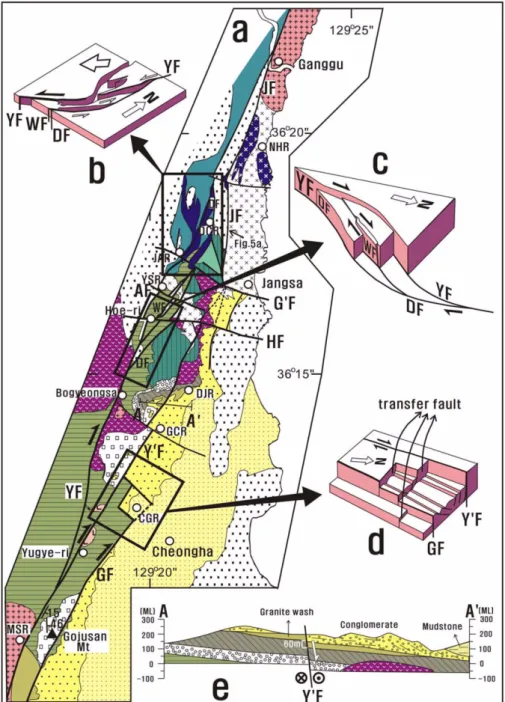
(5) ‘Singwang strike-slip duplex’ around the Pohang Basin, SE Korea. 149. Geological structure in the Ganggu-Singwang area. (a) Detailed map. (b) Emplacement of basalt and extension structure in propagation of sinistral fault. (c) Schematic diagram showing unequal elevation of fault blocks in strike-slip. The Yangsan and Docheon faults seem to form a duplex. (d) Transfer faults in the fault block between the Yugye and Gojusan faults around Cheonggye-ri (CGR). (e) Geological cross section of line A-A’. The dip slip of the Yugye Fault is about 60 meters. AF=Arimal Fault. G’F=Guragol Fanlt. HF=Hoeri Fault. CGR=Cheonggye-ri. DCR= Docheonri. DJR=Daejeon-ri. GCR=Gwangcheon-ri. JAR=Jaengam-ri. MSR=Manseok-ri. NHR=Namho-ri. YSR=Yangseong-ri. For the geological legend and abbreviations, see Figure 1. Fig. 3.. (CGR), northwest of Cheongha, and the extensions of these faults are closely related to the Yugye Fault. These faults, developed in extensional environments, are boundaries between normal faults (Fig. 3d). E-W or WNW-ESE trending faults are recognized around Jangsa such as the Guragol, Arimal and Hoeri faults (Choi et al., 2004; Fig. 3a), and they displaces the Yangsan and Jangsa faults as well as the basaltic masses in a sinistral sense. Note that the Guragol and Hoeri faults also bound the Miocene basin and are also transfer faults relative to the Jangsa Fault. The basaltic body along the Yangsan Fault at Docheon-ri displays a tension structure in the beginning tip of fault. propagation, which may be associated with the dextral block rotation of the Pohang-Ulsan Block (Fig. 3b; Choi et al., 2001).. 3.2. Yugye-Singwang Area The Yugye-Singwang area consists of Cretaceous sediments, Late Cretaceous-Paleogene rhyolitic (bedded) tuff and hornblende granite, and Miocene granite wash and conglomerate. Around the Gojusan Mountain, E- or SE-dipping rhyolitic (bedded) tuff, covering gray sandstone and black mudstone, is in contact with black hornfelsic mudstone that is overlain by the Miocene conglomerate (Fig. 3a)..
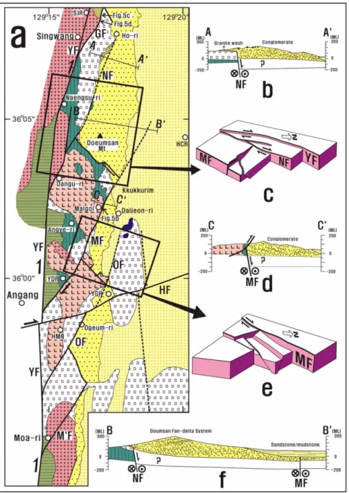
(6) 150. Pom-yong Choi. At Manseok-ri (MSR), granite blocks are mixed in the granite wash (Fig. 2c). At Sajeong-ri (SJR), north of Singwang, granite wash is present in the lower part of the Pohang basin fill and grades upward into Miocene conglomerate (Fig. 3a). Along the Gokgakcheon stream at Sajeong-ri (SJR), a fault contact with approximately 2m-wide gouge zone is observable between the Miocene granite wash (Mgw) and Late Cretaceous-Paleogene rhyolitic tuff (Prt; Fig. 5c). Downstream of the upper outcrop, more than 7 m-wide fault breccia zone is developed along the Gojusan Fault (Fig. 5d). At Ho-ri and Sajeong-ri (SJR), a NW-SE trending vertical fault is developed. The Gojusan Fan-delta System (Sohn, 2004) is developed in the area bounded by this fault and the Gojusan Fault.. 3.3. Singwang-Angang Area At Naengsu-ri, Late Cretaceous-Paleogene rhyolitic and andesitic lapilli tuffs are deposited on the reddish mudstone and dark gray well-laminated mudstone and sandstone (Fig. 4a). Andesitic tuff in faulted contact with the reddish mudstone by the Naengsu Fault. In a cemetery at Dangu-ri, west of the Doeumsan Mountain, reddish mudstone is intruded by felsite (or rhyolite) (Fig. 4a). On the southern side of the Doeumsan Mountain, three NW-striking vertical faults are developed. These three are parallel to each other and developed between the Naengsu and Malgol faults (Fig. 4a, c). During the dextral motion of the NNE-SSW or NE-SW faults, including the Yangsan Fault, the NE-SW compres-. Geological structure in the Singwang – Moa-ri area. (a) Detailed map. (b) Geological cross section of line A-A’. Miocene sediments are deposited on the Naengsu Fault. (c) Block diagram around the Doeumsan Mountain. (d) Geological cross section of line C-C’. (e) Block faulting between the Malgol and Ogeum faults. (f) Geological cross section of line B-B’ showing the Doeumsan Fan-delta System. WF=Winaml Fault. HCR= Hakcheon-ri. HMR=Homyeong-ri. SJR=Sajeong-ri. YDR=Yangdong-ri. YGR=Yugeum-ri. For the geological legend and abbreviations, see Figure 1. Fig. 4..
(7) ‘Singwang strike-slip duplex’ around the Pohang Basin, SE Korea. sion and NW-SE extension has exerted (Choi et al., 2001). Because the upper three vertical faults are nearly parallel to the extension direction, they seem to be transfer faults. In the geological cross section from Naengsu-ri to Hakcheon-ri (HCR; Fig. 4f), the boundary between the Miocene conglomerate and the basement is not easy to observe, and seems to be an unconformity on the basis of distribution of. 151. conglomerate around there. Topset and foreset of the Gilbert-type delta, belonging to the Doumsan Fan-delta System (Chough et al., 1989; Hwang et al., 1995; Fig. 4f), are observed on a road-cut (Fig. 2a). In the geological cross section at south of Ho-ri (Fig. 4b), nearly horizontal conglomerate bed is in faulted contact with rhyolitic tuff, which corresponds to the concealed. Outcrop photographs of major faults. (a) Trace of the Jangsa Fault between the Jurassic granite (Jgr) and Paleogene rhyolitic welded tuff (Prwt) between Docheon-ri and Jangsa. (b) Outcrop of the Malgol Fault showing that the Cretaceous conglomerate (Ks) thrusted over the Miocene conglomerate (Mcg) at Malgol, Dasan-ri, Gangdong-myeon. (c) Outcrop of the Gojusan Fault displaying two types of gouge zones between the Miocene granite wash (Mgw) and the Late Cretaceous - Paleogene rhyolitic tuff (Prt) along the Gokgakcheon stream at Sajeong-ri, Singwang. (d) Fault breccia zone along the Gojusan Fault in the upper stream. Locations of photographs are denoted in Figures 3 and 4. Fig. 5..
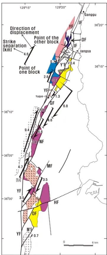
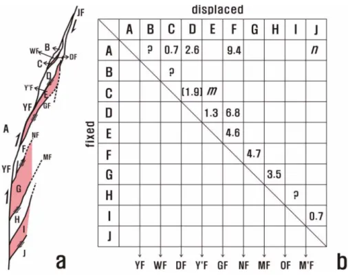
(8) 152. Pom-yong Choi. Naengsu Fault. The flat bedding in this area (Fig. 4b) is interpreted as a shoal-water-type delta (Sohn, 2004). The Malgol Fault is developed from Yangdong-ri (YDR) to Malgol (Fig. 4a). The fault is recognized between the felsite and rhyolitic tuff south of Angye-ri, and between the Cretaceous sediments and Paleogene felsite at Yangdong-ri (YDR). At Malgol, the Cretaceous reddish conglomerate contacts the Miocene conglomerate by a reverse fault (Fig. 5b). This outcrop lies in the extension of the Malgol Fault and indicates that the fault might have been reactivated later. Northwest of Yugeum-ri, conglomerate is also deposited in a depression bounded by the Malgol and Ogeum faults. The rhyotitic (lapilli) tuff, located on the eastern side of the latter fault, is uplifted by block faulting. There are two NEstriking faults that form another small depression between the NNE-SSW trending Malgol and Ogeum faults. The NESE trending Moa Fault developed around Moa-ri is the southernmost branch fault of the Yangsan Fault in the study area (Figs. 1 and 4a). The Hyongsan Fault (Yun et al., 1991; Lee et al., 1992), trending ENE-WSW, displaced the rhyolitic/andesitic tuff and felsite around Homyeong-ri (HMR) and Ogeum-ri (Fig. 4a).. 4. DISPLACEMENT ANALYSIS: A PRELIMINARY APPROACH Displacement is very important in studying the characteristics of a major fault. However, it is not easy to establish displacement markers (or indicators) especially in the basinfill terrain. In this paper, an attempt is made to deal briefly with the displacement problem to estimate the dimension or extension of the branch faults (or connecting faults), and then to reconstruct the linkage of the Yangsan and Jangsa faults. Chang et al., (1990), on the basis of the paleogeographic reconstruction of the Pyeonghae-Busan area along the Yongdok and Yangsan faults, estimated that the displacement of the Yangsan Fault reaches to 35 kilometers. Hwang et al. (2004), on the basis of the correlation of plutonic rocks along the fault, showed that the displacement of the Yangsan Fault of the Gyeongju-Busan area reaches to 21.3 kilometers. In that the Yangsan Fault is a strike-slip fault, one can postulate the displacement markers in terms of horizontal (or strike) separation even with vertical movement. Along the Yangsan Fault, one can find several strike (or horizontal) separation markers such as Paleogene rhyolitic welded tuff to the north of Bogyeongsa Temple, Late Cretaceous andesitic rocks around Bogyeongsa Temple, and Cretaceous hornblende granite around Singwang (Fig. 6a). These indicate strike separations along the Yangsan Fault of 0.7, 2.6 and 9.4 km, respectively, showing an increasing trend southwards. The strike separation between Jurassic granite and Cretaceous sediments along the Yugye Fault is 0.4 km, while a priori. Fig. 6.. Strike separations of faults (unit in kilometers).. that in rhyolite is 1.3 km (Fig. 6). The horizontal separation of the Gojusan Fault reaches to 4.6 km, and that of the Malgol Fault to 3.5 km. However, it is not easy to postulate the horizontal separation markers of the Naengsu and Ogeum.
(9) ‘Singwang strike-slip duplex’ around the Pohang Basin, SE Korea. 153. Results of preliminary displacement analysis. (a) Division of fault blocks in the Singwang strike-slip duplex. (b) Displacement matrix showing the displacement between fault blocks. In the matrix, m designates the displacement of block E (displaced) relative to block C (fixed). n corresponds to the cumulative displacement of the Yangsan Fault in the study area. For the abbreviations, see Figure 1. Fig. 7.. faults. If the lower boundary of the rhyolitic tuff is a good marker, the strike separation of the Naengsu Fault can be seen as 4.7 km (Fig. 6). The strike separation of the Moa Fault reaches 0.7 km. For better description, we establish a strike separation parameter, (X, Y), where X and Y designate the fault blocks (Fig. 7). In the diagram, the X block is fixed, while the Y block is displaced. In other word, (X, Y) is the strike separation of the fault or total strike separation of the faults between the X and Y blocks. We have divided fault blocks on the basis of the Yangsan Fault and eight branch faults. A to J designate the ten fault blocks (Fig. 7a). Here, block A corresponds to the western side of the Yangsan Fault (the boundary fault). The displacement of the northern segment of the Yangsan Fault is now noted as (A, B), that of the Docheon Fault as (C, D) and that of the Yugye Fault as (D, E), and so on (Fig. 7b). So, (A, C)=0.7 km. Assuming that the Yangsan, Winmal and Docheon faults are parallel, the displacement of the Docheon Fault can be roughly estimated: (C, D) ≈ (A, D) - (A, C) = 2.60.7 = 1.9 (km). The strike separation of the Cretaceous (hornblende) granite, (A, F) = 9.4 km, corresponds to the sum of that of the northern part of the Yangsan Fault (bounded by the Docheon Fault) and displacement components of the Docheon, Yugye and Gojusan faults relative to the Yangsan Fault. Designating the rhyolitic tuff masses, from north to south, as R1, R2, R3 and R4, respectively, the strike separation between the R2 and R3 masses is 4.6 kilometers corresponding to (E, F), and that between R1 and R2 marks 6.8 d. d. d. d. d. d. d. d. d. d. d. kilometers, corresponding to (D, F). The cumulative strike separation of the Yangsan Fault in the study area corresponds to (A, J). In order to determine this, the strike separation component of each fault relative to the Yangsan Fault should be determined. This, however, is beyond the scope of this paper, and will be presented in a further paper. Figure 7b summarizes estimated strike separations between fault blocks in a matrix. d. d. 5. LINKAGE OF YANGSAN AND JANGSA FAULTS As mentioned above, a connecting fault is developed between two boundary faults of a duplex and links the boundary faults. In this sense, the Yugye Fault seems to be a connecting fault between the Yangsan and Jangsa faults. The other branch faults of the Yangsan Fault may be linked to the Jangsa Fault, but this is difficult to prove directly; the eastern parts of these faults are covered by the Miocene basin-fill and by Quaternary alluvium, as is the southern extension of the Jangsa Fault. The strike separations of the Yugye, Gojusan, Naengsu and Malgol faults are 1.3, 4.6, 4.7 and 3.5 km, respectively as estimated above. The relationship between the maximum cumulative displacement on a fault, max and maximum linear dimension of the fault surface, , is given as (Kim and Sanderson, 2005); n , max= where the exponent value, , ranges largely from 0.5 to 2.0. d. L. d. cL. n.
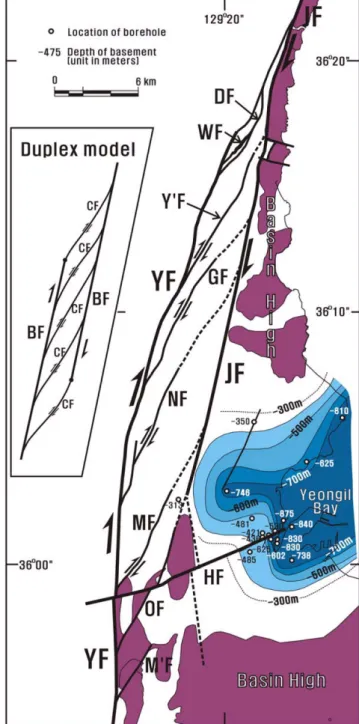
(10) 154. Pom-yong Choi. The fault lengths of the upper four faults are estimated on the basis of the plot of maximum displacement ( max) against fault length ( ) (Kim and Sanderson, 2005) approximately as 90, 360, 360 and 200 km, respectively. The Yugye Fault shows nearly whole extension between the Yangsan and Jangsa faults, and its length between the two major faults is eight to nine km. As to the other three faults, it can be argued that the fault length of branch fault of the Yangsan Fault is much longer than the presently exposed length (ca. 10 km). The southern extension of the Jangsa Fault may be inferred by considering the ‘basin high’ and ‘basin low’ in the basin. Basin high corresponds to the rhyolitic welded tuff distributed from Jangsa to Heunghae, and to the andesitic and rhyolitic tuffs in the inner part and southern border of the Pohang Basin (Fig. 1). Basin high suggests the southerly extension and eastern limit of the Jangsa Fault. The western border of the basin high in the area from Jangsa to Heunghae is roughly assigned to the Jangsa Fault (Fig. 8). The basin low is interpreted from the depth of Miocene basement obtained from boreholes (Han et al., 1986; Hong, 1991; A depth datum near Heunghae was obtained by the geothermal team of KIGAM). The depth of the basement in some parts reaches more than 800 m. Contouring of the depths of the basement displays a basinal form of depression, probably produced due to the extensional tectonics (Figs. 8 and 9a). For easier description, we name it as ‘Yeongil Bay Depression’. Figure 8 illustrates the model of linkage of the Jangsa and Yangsan faults. In the model, the Yangsan and Jangsa faults are boundary faults, and five or six connecting faults are developed between the two boundary faults and link them. Because the boundary faults and connecting faults are mainly strike-slip faults, they display a strike-slip duplex. It is named as the ‘Singwang strike-slip duplex’. In the model, the Ogeum Fault (OF) is the connecting fault extending directly to the southern tip of the Jangsa Fault, and the Moa Fault (M’F) is not linked to the Jangsa Fault (Fig. 8). The middle Miocene basalt was emplaced at Daljeon-ri, that is, in the triple junction of the Jangsa Fault and two faults near the wedge-shaped rhyolitic lapilli tuff (Figs. 4a and 8). d. L. 6. DISCUSSION In order to elucidate the structural characteristics of the Yangsan Fault, we have studied linkage phenomena between the Yangsan and Jangsa faults based on detailed mapping of the Ganggu-Angang area. According to the study results, several faults such as Winmal, Docheon, Yugye, Gojusan, Naengsu, Malgol, Ogeum and Moa faults are branched from the Yangsan Fault and, among them, five faults are linked to the Jangsa Fault (Choi et al., 2004). The linkage of the Yangsan and Jangsa faults produced several connecting faults. These connecting faults and related. Singwang strike-slip duplex. In order to illustrate the linkage of the Yangsan and Jangsa faults, we restored the state before the strike separation by the E-W to WNW-ESE trending faults. But we did not consider the dextral motion of the Hyongsan Fault in order to explain the basal depth of the Yeongil Bay Depression. Here, inferred parts of the connecting faults are noted in dashed lines. The Yangsan and Jangsa faults and connecting faults form an extensional ‘Singwang strike-slip duplex’. The southward extension of the Jangsa Fault, although covered, can be inferred in consideration of the basin highs of rhyolitic welded tuff or rhyolitic (lapilli) tuff. The basin low is drawn through contouring the basal plane depths of pre-Miocene basement. The inset figure illustrates a duplex model comprising boundary faults (BF) and connecting faults (CF). Fig. 8..
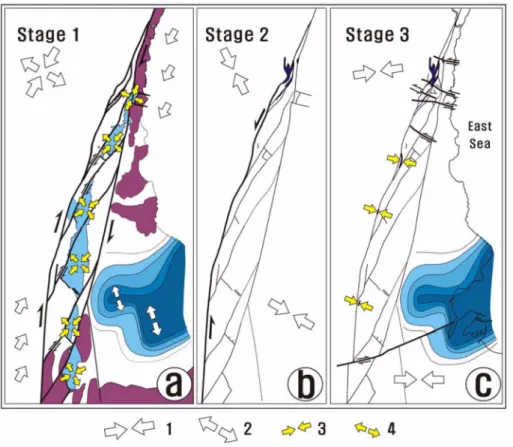
(11) ‘Singwang strike-slip duplex’ around the Pohang Basin, SE Korea. 155. Structural evolution of the study area. (a) Stage 1: Formation of the Singwang strike-slip duplex in the NE-SW compression. Block faulting produced transfer faults during the NW-SE or N-S extension. A deep basin was opened around Yeongil Bay. (b) Stage 2: Sinistral motion of the Yangsan Fault possibly related to the dextral rotation of the Pohang-Ulsan Block (Choi et al., 2001). Basalt was emplaced along the Yangsan, Docheon and Jangsa faults. (c) Stage 3: Sinistral motion of WNW-ESE or E-W trending faults and dextral motion of the ENE-WSW trending fault (Hyongsan Fault). 1 and 2: Regional compression (1) and extension (2) directions, respectively (Choi et al., 2001). 3: Presumed compression direction. 4: Extension direction inferred from the direction of transfer faults. Fig. 9.. transfer faults produced depressions, resulting in the deposition of the coarse-grained sediments in fan-deltas such as the Doumsan and Gojusan fan-deltas (Sohn, 2004). In the area from Gyeongju to Busan, the strike separation of the Yangsan Fault is 21.3 km as estimated on the basis of the correlation of plutonic rocks (Hwang et al. 2004). When comparing both the Ullyonsan Formation in Pyeonghae, Uljin and the Kyongjongdong Formation in Chuksan, Yeongdeok, the strike separation of the Jangsa Fault is estimated to be about 25 km. Chang et al., (1990) presented a paleogeographic reconstruction through the Yongdok and Yangsan faults from Pyeonghae to Busan, and suggested that the horizontal separation of the Yangsan Fault was 35 km. It should be noted, however, that this corresponds to the finite displacement in their reconstruction model. So the value 35 km is not the ‘displacement’ of the Yangsan Fault in the exact sense, but the cumulative strike separation of the Yangsan and Yongdok faults. In the Ganggu-Singwang area, the strike separation along the Yangsan Fault varies from place to place, from 0.7 to 9.4 km, as measured by markers (Fig. 6), displaying an increasing trend to the south. As mentioned above, the strike separation of the Cretaceous (hornblende) granite, (A, F) = 9.4 km, corresponds to the sum of that of the northern part of the Yangsan Fault and strike separation components of the Docheon, Yugye and Gojusan faults relative to the Yangsan Fault. In consideration of the displacements of the Naengsu, Malgol, Ogeum and Moa faults, the cumulative displacement of the d. Yangsan Fault may approximately equate to the horizontal separation determined in the area from Gyeongju to Busan (21.3 km). Branch (or connecting) faults divided the Yangsan Fault into about nine parts in the study area. Each part or each branch fault corresponds to a fault segment. One can take the Yangsan and Jangsa faults for different segments of a large-scale fault. However, the two show different aspects in Quaternary faulting activity; there exist some evidence for the Quaternary reactivation of the Yangsan Fault (Chwae et al., 1998; Ryoo et al., 2000; Kyung and Chang, 2001), but little evidence along the Jangsa Fault. To this respect, the Yangsan and Jangsa faults may be treated as different faults. It should be noted that compressional (or strike-slip) tectonics prevailed in the Singwang strike-slip duplex area, while extensional tectonics was dominant in the southern Pohang Basin area including the Yeongil Bay Depression (see also Son, 1998). Provenance analysis of clasts acceding to the fan-delta systems showed that the “strike-slip movements along the basin margin were inactive during the deposition of the fan deltas and each system was self-sustained” (Hong et al., 1998). Then, did the Singwang strike-slip duplex have strikeslip movements during the sedimentation of Miocene Pohang basin fill?. In the first place, the displacement of the Yangsan Fault varies from place to place as mentioned above. In the area of a small displacement, discrepancy (strike separation).
(12) 156. Pom-yong Choi. between the provenance and sedimentation area can be tri- tion to the block rotation of the Pohang-Ulsan Block (Fig. 9b). fling. In the second place, normal (or block) faulting may have (5) At the recent stage (Fig. 9c), sinistral motion of WNWhappened after the major strike-slip motion of the Singwang ESE or E-W trending faults and the dextral motion of the strike-slip duplex, although the extensional strike-slip duplex Hyongsan Fault occurred. also produced depressions along the connecting faults. As mentioned above, several transfer faults are formed in the Jargon Box fault blocks. Transfer fault is formed in the extensional tectonism as the boundary between the normal fault systems 1. Transfer fault: a boundary fault between rifting or (Woodcock and Fischer, 1986; Milani and Davison, 1988). extensional fault systems (Gibbs, 1990). It is parallel to Northwest of Yugeum-ri (YGR) in the Magol Fan-delta the extension direction. The motion of a transfer fault area, NE-SW trending normal faults are developed (Fig. 4a, e). may display a strike slip, normal slip or oblique slip. This supports the supposition that normal faulting happened 2. Branch fault: a fault branching from a major fault. during or after major strike-slip motion of the Singwang The branch faults developed around the tip of fault corstrike-slip duplex. In the third place, one can consider the respond to splay faults. order of formation of the connecting faults. For instance, 3. Relay fault: a fault connecting two different (prethe northernmost one is produced first and the southernmost existing) faults in linkage (Marchal et al., 2003; Belone in the last. One may suspect it, because the cumulative lahsen and Daniela, 2005). displacement of the Yangsan Fault displays southward 4. Boundary fault: a fault bounding a sedimentary increasing trend as mentioned above. Now, however, the basin (especially used in the pull-apart basin; Sheridan, order of their formation is not detectable and so is inap- 1976) or duplex system. In this paper, the term is also propriate to explain the relative chronology between the applied to the major (parallel or sub-parallel) faults of sedimentation and faulting. a duplex system. 5. Connecting fault: a fault linking two (parallel or 7. CONCLUSION sub-parallel) faults or fault segments (Cruishank et al., 1991; Ferill et al., 1999; Peacock and Parfitt, 2002). In This paper has described three branch faults of the Yang- this paper, the term designates a fault linking the san Fault (including the Winmal, Docheon and Moa faults), boundary faults in a duplex system. more than five connecting faults (Yugye, Gojusan, Naengsu, Malgol and Ogeum faults) and two boundary faults (Yang- ACKNOWLEDGEMENTS: The research was supported by the san and Jangsa faults). Basic Research Project of the Korea Institute of Geoscience and MinAccording to the study results and their discussion, the eral Resources (KIGAM) funded by the Ministry of Science and Techfollowings are concluded (Fig. 9): nology of Korea: ‘Research on crustal evolution of NE Asia’ and (1) In the study area, more than eight branch faults such ‘Neotectonic survey around the nuclear power plants.’ The paper owes as the Winmal, Docheon, Yugye, Gojusan, Naengsu, Mal- much to G.O. An, I.S. Ko and T. Lee of KIGAM who in part helped author’s fieldwork, and to Drs. U. Chwae, W.S. Kee and S.R. Lee gol, Ogeum and Moa faults are developed from the Yang- the from and Prof. Y.S. Kim of Pukyong University who dissan Fault. In consideration of displacement, the extension of cussedKIGAM some detailed parts with the author during preparing the manueach fault is much larger than the apparently exposed fault script. Thanks are dedicated to Prof. Kwon of Yonsei University, Prof. length. In the reconstructed model, the majority of the branch Ree of Korea University and an anonymous reviewer who read carefaults of the Yangsan Fault are linked to the Jangsa Fault, and fully the manuscript and gave constructive comments. The author also they eventually produced an extensional strike-slip duplex, acknowledges Dr. A.J. Reedman for his corrections and comments for improvements to the English manuscript. that is, the ‘Singwang strike-slip duplex’ (Fig. 9a). (2) The Yangsan Fault consists of a minimum of nine seg- REFERENCES ments. (3) Block faulting occurred along the connecting faults Bellahsen, N. and Daniela J.M., 2005, Fault reactivation control on and related transfer faults, resulting in the deposition of the normal fault growth: an experimental study. Journal of Structural coarse grained sediments in fan-deltas such as the Doumsan Geology, 27, 769 −780. and Gojusan fan-deltas. In other word, normal faulting of Chae, B.G. and Chang, T.W., 1994, Movement history of the Yangsan Fault and its related fractures at Chongha-Yongdok area, Korea. fault blocks is believed to postdate the strike-slip motion of Journal of the Geological Society of Korea, 30, 379 −394. the Singwang strike-slip duplex. That is why at this stage, Chang, K.H., Woo, B.G., Lee, J.H., Park, S.O. and Yao, A., 1990, dextral strike-slip component of the duplex is trifling and Cretaceous and Early Cenozoic stratigraphy and history of eastdoes not seem to produce spatial discrepancy in the proveern Kyongsang Basin, Korea. Journal of the Geological Society nance and deposition area of clasts in the Miocene basin-fill. of Korea, 24, 194 −205. (4) As seen in the basalt masses around Docheon-ri, a sin- Choe, M.Y. and Chough, S.K., 1988, The Heunghae Formation, SE istral motion of the Yangsan Fault occurred possibly in relaKorea: Miocene debris aprons in a back-arc intraslope basin..
(13) ‘Singwang strike-slip duplex’ around the Pohang Basin, SE Korea. Sedimentology, 35, 239−255. Choi, P.Y., Kwon, S.K., Hwang, J.H, Lee, S.R and An, G.O., 2001, Paleostress analysis of the Pohang - Ulsan area, Southeast Korea: Tectonic sequence and timing of block rotation. Geosciences Journal, 5, 1 −18. Choi, P.Y., Lee, S.R, Ko, I.S. and An, G.O., 2004, Movement history of the Gaeum Fault System. In: Lee et al. (eds.), Cenozoic stratigraphy and tectonics of SE Korea. The 3rd and 4th Symposiums on the Geology of Korea, Special Publication No. 2, Korea Institute of Geoscience and Mineral Resources, 211−228. Chough, S.K., Hwang, I.G. and Choe, M.Y., 1989, The Doumsan Fan-delta System, Miocene Pohang Basin (SE Korea). Woosung Publication Company, Seoul, 95 p. Chwae, U., Lee, D.Y., Lee, B.J, Ryoo, C.R. Choi, P.Y., Choi, S.J., Cho, D.L., Kim, J.Y., Lee C.B., Kee, W.S., Yang, D.Y., Kim, I.J., Kim, Y., Yoo, J.H., Chae, B.G., Kim, W.Y., Kang, P.J., Yu, I.H. and Lee, H.K., 1998, An investigation and evaluation of capable fault: southeastern part of the Korean Peninsula. KR-98(C)-22, KIGAM, 301p. Cruishank, K.M., Zhao, G. and Johnson, A.M., 1991, Duplex structures connecting fault segments in Entrada Sandstone. Journal of Structural Geology, 13, 1185−1196. Ferrill, D.A., Stamakatos, J.A. and Sims, D., 1999, Normal fault corrugation: implications for growth and seismicity of active normal faults. Journal of Structural Geology, 21, 1027−1038. Gibbs, A.D., 1990, Linked fault families in basin formation. Journal of Structural Geology, 12, 795−803. Han, J.H., Kwak, Y.H. and Son, J.D., 1986, Tectonic evolution and depositional environments of the Tertiary sedimentary basin. KIER Report KR-86-(B)-8, 76 p. Hong, S.W., Chough, S.K., and Hwang, I.G, 2001, Provenance of coarse-grained detritus in the fan-delta systems, Miocene Pohang Basin, SE Korea: implications for boundary fault movements. Geosciences Journal, 2, 46−58. Hong, Y.K., 1991, Petrogenetic modeling of the vertically zoned Cretaceous Pohang epizonal intrusive rocks, SE Korea. Journal of the Geological Society of Korea, 27, 64−86. Hwang, B.H., Lee, J.D. and Yang, K., 2004, Petrological study of the granitic rocks around the Yangsan Fault: lateral displacement of the Yangsan Fault. Journal of the Geological Society of Korea, 40, 161 −178. Hwang, I.G., Chough, S.K., Hong, S.W. and Choe, M.Y., 1995, Controls and evolution of fan-delta systems in the Miocene Pohang Basin, SE Korea. Sedimentary Geology, 98, 147−179. Hwang, J.H., Kim, D.H., Cho, D.L. and Song, K.Y., 1996, 1:250,000 Geological map and explanatory note of the Andong Sheet. KR96 (S)-1, KIGAM/MOST, 67p. Jin, M.S., Kim, S.J., Shin, S.C. and Lee, J.Y., 1989, K/Ar Fission track dating for granites and volcanic rocks in Southeastern Korea. KIER Report, KR-88-6D, 51−84. Kim, B.K., 1970, A study on Neogene Tertiary deposits of Korea. Journal of the Geological Society of Korea, 6, 77−96. Kim, J.Y., 1993, Fault zone and fracture system of the Yangsan Fault. Journal of the Korean Earth Science Society, 14, 281−299. Kim, Y.S. and Sanderson, D.J., 2005, The relationship between dis-. 157. placement and length of a fault: a review. Earth-Science Review, 68, 317 −334. Kyung, J.B. and Chang, T.W., 2001, The latest fault movement in the Yangsan Fault Zone around the Yugye-ri area, Southeast Korea. Journal of the Geological Society of Korea, 37, 563 −577. Lee, H.K., Moon, H.S., Min, K.D., Kim, I.S., Yun, H. and Itaya, T., 1992, Paleomagnetism, stratigraphy and geologic structure of the Tertiary Pohang and Changgi basins. Journal of the Korea Institute of Mining Geology, 25, 337-349. Marchal, D., Guiraud, M. and Rives T., 2003, Geometric and morphologic evolution of normal fault planes and traces from 2D and 4D data. Journal of Structural Geology, 25, 135−158. Milani, E.J. and Davison, I., 1988, Basement control and transfer tectonics in the Recôncavo-Tucano-Jatobá rift, Northeast Brazil, Tectonophysics, 154, 41 −50. Peacock, D.C.P. and Parfitt, E.A., 2002, Active relay ramps and normal fault propagation on Kilauea Volcano, Hawaii. Journal of Structural Geology, 24, 729 −742. Ryoo, C.R., Lee, B.J. and Chwae, U., 2000, Quaternary fault and its remote sensing image in the southeastern Korea. CCOP Technical Bulletin, 29, 5−28. Sheridan, R.E., 1976, Sedimentary basins of the Atlantic margin of North America. Tectonophysics, 36, 113−132. Shibata, K., Uchimi, S. and Nakagawa, T., 1979, K-Ar age results-1. Bulletin of Geological Society of Japan, 30, 675−686. Sohn, Y.K., Rhee, C.W. and Sohn, H., 2001, Revised stratigraphy and reinterpretation of the Miocene Pohang basinfill, SE Korea: sequence development in relation to tectonism and eustacy in back-arc basin margin. Sedimentary Geology, 143, 265 −285. Sohn, Y.K., 2004, Structural and stratigraphic evolution of the Miocene Pohang Basin, SE Korea. In: Lee et al. (eds.), Cenozoic stratigraphy and tectonics of SE Korea. The 3rd and 4th Symposiums on the Geology of Korea, Special Publication No. 2, Korea Institute of Geoscience and Mineral Resources, 83 −106. Son, M., 1998, Formation and evolution of Tertiary Miocene basins in Southern Korea: Structural and paleomagnetic approaches. Ph.D. thesis of the Pusan National University, 233p. Um, S.H., Lee, D.W. and Park, B.S., 1964, Geological map of Korea: Pohang Sheet (1:50,000). Geological Survey of Korea, 21p. Woodcock, N.H. and Fischer, M., 1986, Strike-slip duplexes. Journal of Structural Geology, 8, 725 −735. Yoon, S, 1975, Geology and Paleontology of the Teriary Pohang district, Korea. Journal of the Geological Society of Korea, 11, 187−214. Yun, H., 1986, Emended stratigraphy of the Miocene formations in the Pohang Basin, Part I. Journal of the Paleontological Society of Korea, 2, 54−69. Yun, H., Min, K.D., Moon, H.S. and Yi, S.S., 1991, Biostratigraphic, chemostratigraphic, paleomagetostratigraphic and tephrochronologic study for the correlation of Tertiary formations in the southeastern part of Korea: Regional tectonics and its stratigraphical implication in the Tertiary basin, Korea. Journal of the Paleontological Society of Korea, 7, 1−13. Manuscript received July 12, 2005 Manuscript accepted May 31, 2006.
(14)
수치

+6

관련 문서
Key words: Early Miocene Haseo basin, Hyodongri Volcanics, Sinseori Formation, Hwanseori Formation, Bimodal volcanism Sang Won Yoon, Min-Cheol Kim, Cheol Woo Song and Moon
ABSTRACT : The potential of petroleum generation was investigated by clay mineralogical changes of illite-smectite on the sedimentary basins: Tertiary Pohang basin and
Five clear tectonic events can be found in West Goseong, The earliest E-W compression, is characterized by mode I E-W trending joints, dykes and left-lateral NW strike-slip
Key words : Duho Formation, Hagjeon Formation, Ophiuroidea, Pohang Basin, Tertiary 신생대 제3기 포항분지의 두호층과 학전층으로부터 총 40점의 거미불가사리
(1993) Evolution trends of biotite and hornblende in granitic rocks from Yonghae-Yongdok area, northeastern Gyeongsang basin, Korea. Journal of Korean Institute of
Geosciences Journal Vol 9, No 2, p 145 − 160, June 2005 Major geodynamic and sedimentary constraints on the chronostratigraphic correlation of the lower middle Cambrian transition in
Geosciences Journal Vol 9, No 2, p 117 − 127, June 2005 Eustatic versus tectonic control on the development of Neoproterozoic and Cambrian stratigraphic sequences of the Lublin
An evidence of effects of Miocene igneous intrusions known as diorite sills appears several wells in the study area... Characteristics and tectonic evolution of the East China Sea,
